Diary Entries in English

Recent diary entries

Just a question, when searching for any substation. As an example, here is Pembroke Substation:

osm.org/relation/13110367

However searching using the words “Pembroke Substation” returns significantly wrong results ie: in Bristol, Dublin, and even Florida!

The Name field is spelled correctly as “Pembroke Substation”, copy/pasting these exact words from the Name field into the search bar still can’t find it.

I have only been researching substations in South Wales so far, and they all have had good accurate naming, and are wither a Way if a single entity, or a Relation if more than one Way is used.

Is there a setting somewhere to enable this search? Maybe someone could drop me a message.

Many thanks, Scott

Posted by SLMapper on 12 May 2022 in English.

Introduction

Hi, this is my first osm blog post :-)

Recently I stumbled upon some large areas that where mapped as forest, but Bing aerial imagery showed just a bleak, empty space. I was irritated first, shocked right after - having some thoughts about the earth climate in mind. Only some time later recognized: “Ok, wait. What do you think where your furniture comes from? This kind of thing has to happen. These are actually reneable resources.”

bing

Album, comparing Bing, Esri and Esri Clarity imagery

Checking sources

See full entry

Location: Dumfries and Galloway, Scotland, United Kingdom
Posted by Zverik on 11 May 2022 in English.

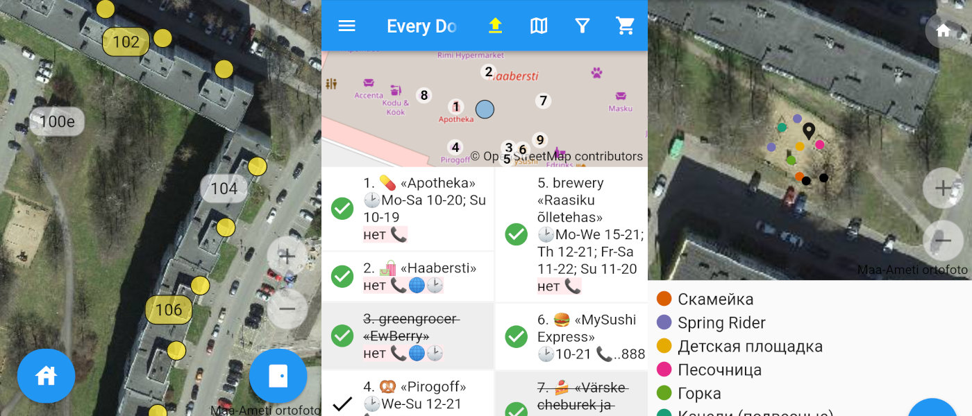
Three screenshots of the editor

Today I’m proud to present my new OpenStreetMap editor. It’s called Every Door and works on both iPhones and Androids. I shared the idea last Summer at a State of the Map, but started writing just late October. In the last month and a half thirty people made ten thousand edits with the editor and helped make it much better. Now I’m launching the open testing.

The official website has links to TestFlight and Google Play, a short video, and a FAQ.

I’ve got just one feeling: at long last. One way or another I was suggesting something like that for OSM since 2013. Made a failed attempt with OpenSurveyor. Watched with hope for big company projects with paid developers — but all these have disappeared. In this time we’ve got one amazing StreetComplete, which I like a lot, although it’s not for me.

See full entry

Now that the weather is more welcoming, i.e. dry, I’ve gone back to mapping walking and hiking trails in my area. I had done that before, either added the trail completely new as a relation with all that’s included, sometimes just added the trail markers, where the trail was already mapped. Most times, I try to do mapillary as well, sometimes just with the phone, sometimes with a 360° camera.

Today, I went to map the O’Gorman’s Lane Loop which is only a 4km walk (that is if you don’t get lost…), but it meets another, longer trail which was already mapped. But anyway, I ran into an American couple, Don and Kim who are exploring Ireland on rented motorbikes, but are also avid hikers and have hiked across the Czech Republic, Germany, Switzerland etc. Don was telling me that he has this app maps.me which shows all the trails and it’s free! And I said, well, it’s people like me who add those trails to OpenStreetMap which in turn adds it to your app. We parted ways, but I had a suspicion that I would run into them again after in the only café in the village. And I did. I walked up to them and gave him an openstreetmap.ie sticker (always handy in any bag I carry around). Once I had taken off my backpack, he could see the “OpenStreetMap surveyor” on my high viz vest, and the penny dropped. He had loads of questions and all the right ones, so I joined their table and chatted away with him.

He said that he wanted to map all the benches along the Camino. :D (We had noticed earlier that there are never enough benches along hiking trails in Ireland.) He also wants his name on one of those benches, and I explained that those little plaques can be added to OSM as well. He was very impressed, I think. They wanted to pay for my scone, but I had already paid. But we decided to share a taxi back, even though I would have been fine on the bus, and had told them about the bus as well.

See full entry

Posted by Allison P on 8 May 2022 in English. Last updated on 22 May 2022.

Cartography is an artform. Besides being used for art, it is a practice rooted in subjectivity. For most people, it may be only a means of navigation, but any cartographer acknowledges that they make decisions based on their own opinions when making maps. OpenStreetMap is one of the more objective maps out there, but it’s still not always clear how to map things. As a community, we’ve had to make numerous decisions on the “best” way to map something. Sometimes, we don’t have a singular answer. Users of OpenStreetMap data must interpret these decisions as best they can. Tagging is usually what comes to mind when considering what comes into dispute here, but scope is important as well. And this is where privacy comes in.

Privacy status quo

We have some privacy standards. Besides GDPR compliance, the Data Working Group redacts edits that introduce personal information, such as annotations intended for an individual that may link their account to a real person. It generally isn’t acceptable to map features inside private residences either, like rooms or toilets. These may come as common sense to most, but others still could have counterpoints. The level of detail most are comfortable with is what is visible from street level or the sky. I think this is a good standard, but some are still left uncomfortable. There’s the occasional new mapper who deletes driveways leading to single-family homes. It may not even be their own driveway, but some may be unfamiliar with OpenStreetMap’s tagging system that makes it clear when a driveway is private and that it is, indeed, a driveway. One cannot fault a person for wanting privacy; the concern then is about damaging data (digital vandalism). At least where OpenStreetMap is based, there is no law against making a map of someone else’s property. Legal concerns about cartography are a separate matter not related to individual privacy, which is my focus here.

See full entry

Location: Anchorage, Alaska, United States
Posted by xrisnik on 7 May 2022 in English.

I got tired of adding addresses to hundreds of houses, so reluctantly decided to research custom presets. What a pleasure it turned out to be - I recommend it. Here is all it took:

<?xml version="1.0" encoding="UTF-8"?>

<!--
* Put this file in ~/snap/josm/common/  [This is specific to Ubuntu Linux]
* Add to JOSM by selecting  Edit / Preferences / Tagging Presets
* and then press '+' on the top-right, then specify the path to this file.
-->

<presets 
  author="xrisnik" 
  version="1.0" 
  shortdescription="Presets File" 
  description="Setting residential building and address in JOSM">

  <item name="Residence + address" type="closedway">

    <label text="Edit"/>

    <space />

    <combo key="building" text="Residence type" values="detached,terrace,semidetached_house,apartments" display_values="Detached,Terrace,Semi,Apartments" default="detached"/>

    <text key="addr:housenumber" text="Number" default="" delete_if_empty="true"/>

    <text key="addr:street" text="Street" default="" delete_if_empty="true"/>

    <space />

  </item>

</presets>

Hey world! I’m Osinachi and this is my first diary entry. I am a beginner mapper and the map my village campaign is the first project I am engaging in. I have found it really exciting for the five days I’ve mapped so far. I am thrilled by the opportunity to make my village globally accessible. I have been able to map a lot of buildings so far with the ID editor. As magnificent as it has been, I have also encountered some issues with the images. I will really appreciate it if they were clearer but all in all, it’s been great. I hope you all will contact me if there are any campaigns. I enjoy doing volunteer activities. They make me feel like my life has been worth living. Thanks so much for this space OSM! Happy mapping

Opening up streetlevel imagery

With OpenStreetMap Belgium and our umbrella Open Knowledge Belgium, we have been lobbying to get governments to collect their street level imagery in the open.

While there are many projects to collect images, almost allways the government does not retain ownership of the imagery. Instead of paying for data collection, they pay for access to the data. This means the price is low for the individual governement organization, but in our complicated political landscape of federal, regional, provincial, intercommunal, or communal organizations, many are buying access individually. In the end, the total cost for the tax payer is higher, without there being any open products that can benefit the rest of society.

We believe payment for the data collection should happen only once, and ownership of the imagery should be transferred to the government. This would result in the lowest cost overal. By releasing the imagery as open data, its value for society is increased even more. Access to extra services can incentivise governements to pay up for the base data collection.

Slow progress

While the intercommunal organization WVI (Dutch text) has contributed open 360° imagery for most of the industrial areas in West-Flanders, and three Flemish municipalities have shared 360° imagery taken by Vansteelandt, the vast majority of projects that we hear about do not result in open data.

This is why in 2022 we are launching the Open StreetLevel Imagery Project. We are scaling up our efforts to crowdsource open street level imagery at a low cost. We are investing a very small budget which we expect to have a significant impact.

The OpenStreetMap Belgium role

See full entry

Location: Nil-Saint-Vincent-Saint-Martin, Walhain, Nivelles, Walloon Brabant, Wallonia, 1457, Belgium

Opening up streetlevel imagery

With OpenStreetMap Belgium and our umbrella Open Knowledge Belgium, we have been lobbying to get governments to collect their street level imagery in the open.

While there are many projects to collect images, almost allways the government does not retain ownership of the imagery. Instead of paying for data collection, they pay for access to the data. This means the price is low for the individual governement organization, but in our complicated political landscape of federal, regional, provincial, intercommunal, or communal organizations, many are buying access individually. In the end, the total cost for the tax payer is higher, without there being any open products that can benefit the rest of society.

We believe payment for the data collection should happen only once, and ownership of the imagery should be transferred to the government. This would result in the lowest cost overal. By releasing the imagery as open data, its value for society is increased even more. Access to extra services can incentivise governements to pay up for the base data collection.

Slow progress

While the intercommunal organization WVI (Dutch text) has contributed open 360° imagery for most of the industrial areas in West-Flanders, and three Flemish municipalities have shared 360° imagery taken by Vansteelandt, the vast majority of projects that we hear about do not result in open data.

This is why in 2022 we are launching the Open StreetLevel Imagery Project. We are scaling up our efforts to crowdsource open street level imagery at a low cost. We are investing a very small budget which we expect to have a significant impact.

The OpenStreetMap Belgium role

See full entry

Location: Nil-Saint-Vincent-Saint-Martin, Walhain, Nivelles, Walloon Brabant, Wallonia, 1457, Belgium

It was amazing and exiting to have our Unique mappers community joining again for the 1-week Mapathon Webinar #mapmyvillage . Good to have Raph-the HOT Global Validation Team lead joining us to handle the validation training room.And thanks to Kingsely and Chiosm Okwuchi for amazing job in the beginners room and advance mappers room. We had maore participants joining to learn how to map thier villages in OSM

I live in the country of Jordan and I was excited as soon as I heard of this project from a youtuber called Sebastian Lague.

Until now my modest contributions consist of the following: 1. I fixed residential area lines. 2. Fixed local features and public buildings such as mosques and churches and defined their outlines respectively. 3. Added more building tags and outlined many buildings and attractions with schools and parks.

Location: Rabyeh, Al-Jami'ah Sub-District, Al-Jami'ah District, Amman, 11182, Jordan
Posted by lucku on 3 May 2022 in English. Last updated on 4 May 2022.

I discovered this site a week or two ago. It seemed awesome! I definitely never knew there was a map wikipedia, where people all around the world have poured probably thousands of hours to detailing!

I discovered the project from a youtube video and it instantly caught my attention. These days cartography is mostly looked down at because with a click of a button you can pull up google maps, but this project can help others + more.

I wanted to help, so I turned to my hometown of San Diego. It definitely isn’t small, but the neighborhood I lived in for the longest time (La Jolla) is. I only recently moved away!

I have begun at northern La Jolla Village. Working my way down every little detail. I’d say I’ve done quite well so far! I look forward to mapping when I’m bored or feel like it, it’s kinda calming just drawing shapes and lines over a map for some strange reason.

Lucku signing off.

PS. I edited the original first diary because I wrote it too quickly.

Location: Beach Barber Tract, La Jolla, San Diego, San Diego County, California, 92037, United States