Diary Entries in English

Recent diary entries

If you want to import OpenStreetMap data to PostgreSQL (+ PostGIS) database two popular tools are osm2pgsql and imposm3.

Both were designed to prepare data for rendering although some time ago osm2pgsql was upgraded with scripting capabilities that go beyond simple mapping files that specify what tables to create and what objects should be inserted there (filter by tags).

There is also osmosis if you want a - more or less - copy of OpenStreetMap database.

imposm3 development was put on hold due to lack of funding while osm2pgsql is actively developed. This makes it questionable choice to use imposm3 but it does have some nice qualities that can make it better for some projects.

In my opinion it’s a very good tool that is useful when:

  • you have a webapp and want to use OSM data but Overpass API is too slow/limited
  • you want to use OSM data for spatial analysis and keep it updated

** The rest is of the text including instructions how to import data is in my github page: https://ttomasz.github.io/2022-04-08/osm-import-data-with-imposm **

Posted by jmapb on 8 April 2022 in English. Last updated on 29 May 2023.

[continued from part 1]

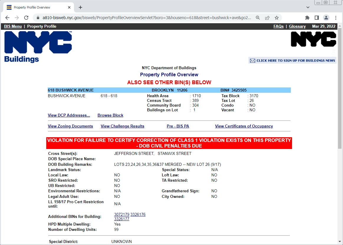
Carrying on with my Brooklyn survey… In the Bushwick neighborhood, I’ve found another new building to map, and a good opportunity to show a little more of NYC’s Building Information Search tool (aka BIS.). Like last time, we’ll start by finding the building’s BIN and height using BIS’s search option 1, with borough Brooklyn, housenumber 618, and street Bushwick Avenue. Here’s the resulting Property Profile Overview page:

BIS Property Profile Overview of 618 Bushwick Avenue

(That exciting red bar means this development is currently in trouble with the Dept of Buildings, but that’s none of my business.) We find the BIN, 3425505. Note the “ALSO SEE OTHER BIN(S) BELOW” message and the “Additional BINs for Building” field – these are older obsolete BINs that this new building has supplanted. The “DOB Building Remarks” note about multiple lots being merged tells the same story, which is a very familiar one in Brooklyn: A large new building has replaced several smaller buildings.

See full entry

Location: Brooklyn, Kings County, New York, United States

Hi all,

MapComplete has been (partially) translated in 21 languages by now - an amazing feat that I could never have done alone (for starters, I don’t speak 21 languages).

(For those that don’t know MapComplete - it is an easy-to-use map viewer and map editor. It shows POI on the map and when clicking something, shows the known information and asks questions about it)

Translating MapComplete started by manually editing the translation files, making a pull request, … A next step was moving over to Weblate, where there is more support for translations.

However, one has to know where to find this translations and translating can be tricky, figuring out which piece of text goes where.

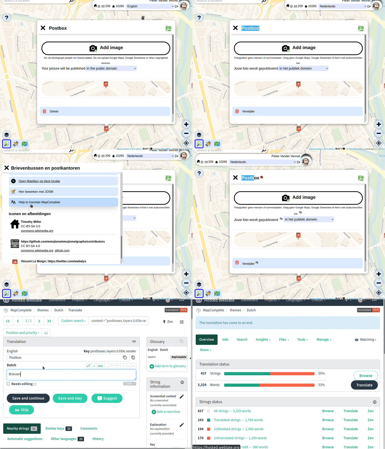
That is why I launched a new feature today: toggling ‘translators mode’ (in the copyright tab) will add little buttons, taking you directly to the page to translate the string (or to fix some typos):

So: please help to translate MapComplete in your favourite language!

Some remarks:

See full entry

Posted by Skunkman56 on 6 April 2022 in English.

I am really glad Cad-Man are rendering- WC still seems to have a problem. I did have it as administrative boundary for a bit with the admin_level tag, but I think the admin_level tag was throwing me off- that tag seems to be specific in the US for certain values (=6), regions(=5), etc. Scrubbing the admin_level tag seems to help.

There are still a few national forests kicking around with the boundary=national_park tag to clean up, and there are probably national parks mapped as such that have private inholdings within them not depicted- only the outer boundary is mapped. Case in point, though not a national park, is Adirondack Park- osm.org/relation/1695394. Adirondack Park is a stretch since there is no national designation for that, unlike National Forests and National Parks. I agree the green line render is a bit much if we used the boundary=national_park tag, and the consensus from the mailing lists seems to be a strict literal interpretation of national “park”, if anything to keep people getting confused- best to stay conservative with the interpretation.

I also made some progress on the Mackinaw State Forest - Gaylord Unit late yesterday and should be done with that one. Then back to fix up the Lake Superior State Forest units. The fix for Tahquamenon Falls State Park seems to be rendering when zoomed in. The Newberry Unit is rendering also- osm.org/relation/13993909. Shingleton and Sault Ste. Marie still seem to have problems. I would have liked to move on to the Pere Marquette but a little detour to the UP was a nice change.

When I was a kid, my dad relied on an over-sized atlas depicting roads, towns, public lands, lakes and streams at the county level. He used this on road-trips, consulting it while exploring to determine if uncertain just which way to go. Signs were important- the signs marking the corners of state game areas. Road signs. County boundary signs. They were a navigational aid. When I got old enough, he gave me my own atlas. By that time however, the internet provided a bevy of informational maps at much smaller scale- letter-size maps showing individual public lands, trail maps, and much more. Updated and more accurate than the old atlas often based on commercial data sources and the 24,000-scale series of USGS topographic quadrangle maps. Today, we can make our own paper maps using online mapping applications, consult a digital map on a cellular-connected smartphone pocket computer or wristband computer, create our own spatial data using high-accuracy GNSS or heads-up digitizing from remotely sensed products, or even contribute to the public world-wide map of OpenStreetMap. There are so many options in this new digital environment to explore and find uses for. It’s wonderful today when we still have our over-sized paper atlas or folded maps available at any outdoors store, but also so many more options to access, create, and share maps. So whether you have a paper map in your pocket, or a mobile remote connection to the world-wide digital map, or a window onto the world from your home computer, I hope you find great experiences exploring and learning more about the world.

I have no answer as to whether it is useful. Now I am not talking about real benefits, but about intentions

They did nothing useful for Ukraine map before. They do not worry, about OSM data, even if they talk about it. They want the Russian army to do the same to us as in Bucha. They are passive supporters of Putin. I think that such guys have no place in OSM

https://community.openstreetmap.org/t/country-based-authorizations/838

Posted by Skunkman56 on 5 April 2022 in English.

The ways representing the Manistee and Cadillac ranger districts now are split out into separate relations. For the Manistee National Forest super-relation, I added a way to represent the administrative Forest boundary, snapped to the adjacent outer edges of the ownership ways. This gives some geometry for the relation when you search for and pull it up. To avoid confusion over actual ownership/extent of protected_area / leisure=nature_preserve, I scrubbed those from the Manistee relation and they are only on the district subarea relations. Manistee is tagged boundary=administrative, the subareas tagged boundary=protected_area. We will see how the tagging savants respond to this strategy. I did add an admin_level=6, the equivalent of the county level, to help show the Manistee admin boundary at a wide zoom level. Maybe it will work. I thought about adding a government=forestry tag as well to show that it’s not a civil\municipal admin boundary, but didn’t add it:

osm.org/relation/11565336

Splitting Cadillac and Manistee resulted in some simpler geometry. Previously the ownership extent protruded out into Hodenpyl dam pond, so I brought that back to the shoreline (snapped to edge of natural=water). Still need to add an admin_centre node for the Cad-Man office in Manistee and the Forest HQ in Cadillac.

In other news I added in the 5000-acre Dunbar experimental forest in the eastern UP, it’s a MSU property, I tagged it with the university as the operator and leisure=nature_reserve. I saw a Notre Dame school Forest somewhere in the W UP already in OSM and I know UofM and MTU have school forests too. And there are county forests too- Marquette has a big one near the old Air Force base. I Still need to get back in and finish up the Mackinac State Forest, Lake Superior State Forest, start on the Pere Marquette. And sometime or another see what’s wrong with the Ottawa NF. Gotta fill in the northern lower and UP!

Andy

Posted by Yabba on 5 April 2022 in English. Last updated on 7 April 2022.

By this following scipts you get the “gmapsupp.img” for a lot Garmin devices and another file “OSM map.gmap” for the Garmin BaseCamp Application on macOS and Windows. I’m on macOS, for Windows use your own creativity or ask other competent people, please. The Linux way is very similar.

You need the latest Splitter from “http://www.mkgmap.org.uk/download/splitter.html” Get the latest Snapshot of mkgmap from “http://www.mkgmap.org.uk/download/mkgmap.html” If you like, choose a *.typ file of your choise or create your own. Some samples are in the downloadable files included.

And finally you need osmconvert. Get it from Gitlab:

#!bin/bash
wget -O - https://gitlab.com/osm-c-tools/osmctools/-/raw/master/src/osmconvert.c | cc -x c - -lz -O3 -o osmconvert

Get your desired regions from GeoFabrik http://download.geofabrik.de like:

#!bin/bash
wget -t0 -c http://download.geofabrik.de/africa/canary-islands-latest.osm.pbf
wget -t0 -c http://download.geofabrik.de/europe/poland-latest.osm.pbf
wget -t0 -c http://download.geofabrik.de/europe/spain-latest.osm.pbf
wget -t0 -c http://download.geofabrik.de/europe/germany-latest.osm.pbf

Check the GeoFabrik Website for the latest updates.

See full entry

Обращение к сообществу OSM и к его участникам!

Россия вероломно напала на Украину 24 февраля 2022 года, нанося ракетно-бомбовые удары по аэропортам, воинским частям и объектам гражданской инфраструктуры. Это явилось очередной эскалацией военных действий, начавшихся в 2014 году с момента захвата Крыма и частичной оккупации Донецкой и Луганской областей.

Мы, сообщество OSM Украина, в связи с продолжающимся военным вторжением России на территорию Украины обращаемся к людям, которые вносят свой вклад в развитие и улучшение данных OSM.

Мы призываем всех воздержаться от какого-либо маппинга на территории Украины в данный момент!

Российско-украинская война идет на многих фронтах, в том числе и на информационном. Возможное использование российскими захватчиками открытых данных для планирования атак на военные и гражданские объекты является одной из важнейших причин, по которой мы просим не предпринимать каких-либо действий по маппингу объектов на территории Украины.

В случае обнаружения случаев маппинга, касающегося военных объектов или объектов критической социальной инфраструктуры, мы будем их корректировать (удалять, видоизменять, откатывать к предыдущему состоянию и т.д.), а также обращаться в DWG и в другие рабочие группы OSMF для блокирования участников, которые систематически вносят подобные изменения (больше одного).

Такая просьба (требование) перекликается с положениями статьи 114-2 Криминального кодекса Украины, согласно которой “Распространение информации о перемещении, движении или расположении Вооруженных Сил Украины или других образованных в соответствии с законами Украины военных формирований, при возможности их идентификации на местности, если такая информация не размещалась в открытом доступе Генеральным штабом Вооруженных Сил Украины, совершенное в условиях военного или чрезвычайного положения, наказывается лишением свободы на срок от пяти до восьми лет” (https://zakon.rada.gov.ua/laws/show/2160-20#n10).

Источник: osm.wiki/RU:Russian-Ukrainian_war

An appeal to the OSM community and its members!

Russia treacherously attacked Ukraine on 24 February 2022, striking with missiles and bombs at airports, military bases and civilian infrastructure. This was another escalation of hostilities that began in 2014 with the annexation of Crimea and the partial occupation of Donetsk and Luhansk Regions.

On behalf of the OSM Ukraine in connection with Russia’s ongoing military invasion of Ukraine we are turning to people who are contributing to the development and improvement of the OSM data.

We urge everyone to refrain from any mapping of the territory of Ukraine at the moment!

The Russo-Ukrainian War is unfolding on many fronts including the information one. The possible use of open data by Russian invaders to plan attacks on military and civilian objects is one of the most important reasons why we ask you not to perform any mapping of objects in Ukraine.

We shall take action to amend (delete, modify, revert to the previous state etc.) any found cases of mapping related to military or critical social infrastructure facilities as well as contact the DWG and other OSMF working groups to ban the users who systematically make similar changes (more than one).

Such a request (demand) echoes the provisions of the Article 114-2 of the Criminal Code of Ukraine according to which “Dissemination of information on redeployment, movement or location of the Armed Forces of Ukraine or other military formations established in accordance with the laws of Ukraine, if it is possible to identify them on the ground, if such information is not published by the General Staff of the Armed Forces of Ukraine, committed under martial law or state of emergency, shall be punishable by imprisonment for a term of five to eight years” (https://zakon.rada.gov.ua/laws/show/2160-20#n10).

From osm.wiki/Russian-Ukrainian_war

I love mapping botanical gardens. So when State of the Map US wrapped up last weekend, I was excited to make a return trip to Tucson Botanical Gardens for some serious micromapping. I had already spent hours adding buildings, garden spaces, and trails. Now I could work on benches, fountains, artwork, etc. Here’s how it looks after a few more hours of micromapping:

Tucson Botanical Gardens on OSM.

The garden currently has an augmented reality exhibition called Seeing the Invisible. Users download an app, and it overlays 3D images of artwork over the plants you view through your phone. Any time I use an app like this, my first question is “What map are they using for navigation?” In this case it was very unclear because there was no attribution on the map or on the Credits page. You can view the map here.

See full entry

Location: Palo Verde, Tucson, Pima County, Arizona, 85716, United States
Posted by DeBigC on 4 April 2022 in English.

I have put the following item on the Irish mailing list. I will put it here to widen out the inputs. If you have some time, and some experience of adding this landuse. Rather than repeat all my concerns I will simply post visual some examples of the issues I am talking about here.

Example of an urban landuse=residential which is gigantic.

Example of a landuse=residential interpreted at running along a roadway to incorporate ribbon(roadside) developments. This landuse connects a huge number of disconnected places.

Example of a landuse=residential residential where the landuse is trimmed back from the public highway and walkway, and doesn’t extend beyond the collective block of properties.

Posted by JamJar II on 4 April 2022 in English.

Over the last few weeks I have been looking at 3D rendering of OpenStreetMap data. Much of the focus has been on the old town of Dunkeld in Perthshire, Scotland.

I learn iteratively combining trial and error with reading documentation. Different rendering options like demo-f4map.com and Kendriz3D plugin in JOSM provide my informational feedback loop. The former is easier to use but the Kendriz3D plugin is quicker to see the updates I make.

I went house number surveying with StreetComplete yesterday in Callan, Co. Kilkenny. They have some very strange house numbering there, I can tell you.

One case, where whoever screwed the numbers on the door got them mixed up, so the sequence goes 34, 35, 63, 37 etc. But that’s what’s on the door, so that’s how I mapped it.

Another case, where the sequence is out of order, but presumably, because the houses got their number in the order they were built in.

Then I continued along Mill Street into what would eventually become Collins Park with a sign of the name in English and Irish in a wall (mapillary), so at least, I had some idea of the street name. However, the numbering continued from Mill Street (with ridiculously high numbers for Ireland, if I may add). I decided to ask the resident of no. 462 what street he lived on, and his answer was “The sat nav says Collins Park.” Very likely (everybody I know who isn’t a mapper uses it), that means GoogleMaps. So, what street do I put under addr:street? Do I follow the logic of the sequencing and give his house addr:street=Mill Street, yet adding “Collins Park” as the name to highway=street or do I follow the local’s information which in this case is very, very likely taken from Google? And which could easily lead to duplicate numbers for the same street?

I’ve done it the other way around for now, but I’m not happy with it.

A similar problem occurred elsewhere, where the name of the street “Green Lane” presumably continues from where I saw the only sign (sorry, no photograph, but it’s the street that led/ leads to the Fair Green), but the sequence on one side of the road continues from Mill Street, but across the road, one of the houses had “2 Kingscourt” (mark the different spelling from the actual street name - Kings Court - , FFS, isn’t anything easy in Callan?!). After my tagging, the houses on either side belong to different streets which they are not physically on.

See full entry

Location: Bolton, Callan Rural, The Municipal District of Callan — Thomastown, County Kilkenny, Leinster, Ireland
Posted by ExpresswayDave on 3 April 2022 in English.

I know it’s been about two years since I’ve written an entry in here. Truth is that I haven’t been mapping as much as I used to and inclined to write about it even less.

That said I haven’t been completely idle:

  • Added more details to Vermillion Regional Airport in Danville, Illinois. Having been a member of the Illini Glider Club allowed me to do that since I was going there pretty much every weekend. Unfortuntely I had to give it up when I became unemployed in November of 2020, but I’ve been at my new job for almost 6 months now and I plan on rejoining sometime between mid-July and early August.
  • I added the bike lanes and sharrows along Main Street in Urbana from downtown to the Kickapoo Rail Trail. I did this over a year ago and was surprised no one else had done it since it’s the main connector between the rail trail and the rest of the bike routes in the Champaign-Urbana area.
  • Cleaned up/added the bike lanes and sharrows in downtown Champaign. I added the bike lane along Walnut Street (which unfortunately doesn’t have one going in the opposite direction on one of the adjacent streets, unless you count State Street, which I don’t), added the bike lane along Clark St/Logan St, removed the bike trail marking along Clark St west of Randolph since it’s not marked with signs or pavement markings (it’s marked as one in the Champaign County Bikes map only)
  • Added more maxspeed and minspeed tags in Iowa and Illinois. Besides the motorways I’ve been paying attention to US 30 in and east of Cedar Rapids, IA 38, and IA 130. A hint for other mappers who want to add maxspeed tags for highways that go through small towns: like Pennsylvania the speed limits in Iowa tend to change in or near the city limits of these towns, though Iowa’s a bit more flexible than Pennsylvania is. Also, adding minspeed tags to the Interstates in Iowa and Illinois is easy since you can just download and select all the members of the route relations for them and add them that way.

See full entry

Posted by Minh Nguyen on 1 April 2022 in English. Last updated on 3 April 2022.

Recently there have been well-reasoned calls to give users blunt feedback when they have strayed. It came to my attention that the wiki has no built-in feature for this social interaction, only the reverse. I have implemented a user script that allows you to chide another user for an edit. For example, I stridently disapprove of this edit from a year ago:

See full entry

Location: Darré Peyrahitte, Lies, Bagnères-de-Bigorre, Hautes Pyrenees, Occitania, Metropolitan France, 65200, France
Posted by unen on 1 April 2022 in English. Last updated on 2 April 2022.

The OSM Help Desk of the Open Mapping Hub Asia-Pacific is slowly and steadily continuing while we discuss different matters with different people every week, both online and offline, when scheduling and connectivity doesn’t allow us to meet online. And I am also personally enjoying these discussions since I am too, refreshing or expanding my knowledge on some topics along the way. So please keep the appointments coming via this online form.

Discussion Topics:

  • ”I am part of an organization and we want to be advanced OSM contributors.”

There are lots of entry points to get to know about Openstreetmap: Wiki being the main one and LearnOSM another very good resource for this purpose.

But if you’re also aiming to gain expertise and become trainers in your community, or planning high-impact mapping projects and activities and want to build capacity on those, please let HOTOSM or the Open Mapping Hubs in Asia-Pacific, Eastern and Southern Africa, Northern and Western Africa or Latin America to learn how they could help you achieve these goals.

  • ”I would like to learn how to map properly. Especially on Tasking Manager.”

Again, the Tasking Manager section of LearnOSM is going to provide almost everything you need to know on how to properly contribute to OSM using Tasking Manager.

Additionally, please feel free to use and distribute this little cheat-sheet we’ve recently put together at the Hub. Squeezed in and packed up knowledge for you, bragging rights for us :)

You can access the cheat-sheet here

Location: 40.946, 29.107