Diary Entries in English

Recent diary entries

Recently, I added a new category, which shows all heritage protected items (at least those, which are tagged correctly in OpenStreetMap). Additionally, I created a web-application which helps tagging heritage protected items in Austria (and Berlin, Germany). I blogged about this here.
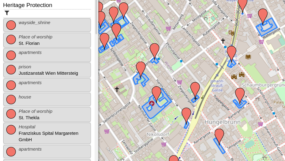
Screenshot of OpenStreetBrowser, showing the "Heritage Protection" category.

On 11 December 2012 LionMapperTeam Nsukka, in collaboration with UniqueMapperNetwork Nigeria, hosted a webinar on Volunteerism and Membership, Talking about Volunteerism a person who works for an organization without been paid for it, because they want to do it. A volunteer is someone who offers to do a particular task or job without been forced to do it. A volunteer Member is a person who is or has been designated by the governing board of an organization and who is faithfully and actually performing volunteer service in that organization. example of a Volunteer Member@ UniqueMapperNetwork, LionMapperTeam, YouthMapperNetwork etc. THE BENEFIT OF VOLUNTEERISM can never be overemphasis it opens opportunities, it Connect you to friends and experts, Create networking, Resume and CV advantage, improve professionalism and develop skills(Soft and Hard skills) expose individual to different skills, give one the advantage of presenting at different summit, workshop, training and seminar.

See full entry

Today been 27 November 2021, I lead a talk with a team of Lion Mapper Nsukka, Nigeria. on the discuss of OpenStreetMap and HOT Tasking Manager as a tool for free open data mapping and it is free user approach for individual and organizations. OSM and HOT came into existence as an open data source due to lack of data availability about a location, on how to solve environmental issue was a challenge in the 80s. Created in 2004 by Steve Coast in the UK, who initially focus on mapping United Kingdom to help in free and widely distribution of data for everyone to use. OSM is a community owned and supported by OpenStreetMap foundation located in England and Wales. OSM provides geographic data with over 2 million users across the world. OSM and HOT Tasking Manager is open for volunteerism, were Mappers and individual can team up to contribute to open data mapping of their community by providing information about an unknown location via mapping (Mapathon) to be known. Volunteers here in OSM and HOT Tasking Manager help to contribute in open data mapping about disaster management and response of a location, were in turn aid disaster response team and organization to have access to that particular location. Data is save in OSM and HOT Tasking Manager database for future use by Government, NGOs and private organization who are thrilled and concern about the human and natural environment in response to any disaster or environmental challenge about a place which require a location based information.

Posted by John Stanworth on 22 December 2021 in English.

Strava has recently published its annual report. Like last year it reports a huge increase in users - globally 2 million people join every month, here in the U.K. 17% of the population now use the app. I can’t find a thank you to OSM mappers in the report but nevertheless I think we can take a lot of the credit for its success. The app and all its runners, walkers and cyclists are dependent on the paths and roads that we have mapped and are still mapping. They must surely be one of the biggest groups of OSM users.

Posted by bo_hot on 16 December 2021 in English. Last updated on 17 December 2021.

Hi all,

Some of you may remember earlier this year we conducted an experiment to compare traditional mapping with ai-assisted mapping. Below is our summary of findings and the full report for those who may be interested. We hope this experiement will be the start of the conversation of how we can ethically and responsibly introduce AI augmented mapping workflows into HOT’s work in 2022.

Humanitarian OpenStreetMap Team, comparison of traditional digitizing of building features in OpenStreetMap of machine learning assisted building digitization

Key findings:

  • Although most participants were new to AI-assisted mapping, the majority of participants were open and likely to integrate it into their workflows.
  • For beginner mappers, AI-assisted mapping drastically increased their mapping speed, but had no significant effect on their quality
  • For advanced mappers, after a small mapping slow-down, AI-assisted enabled more efficient mapping without impacting their quality
  • Open models offer significant potential impact and value for humanitarian response
  • More data created through AI-assisted mapping may exacerbate the ‘validation bottleneck’

In the last 10 years, the use of AI/ML in the geospatial sector has boomed. Private sector, academic and nonprofit organizations alike have been investing significant thought, time and resources into exploring and testing the potential and possibility of how AI/ML can augment and amplify current GIS workflows.

Unfortunately for the open mapping community, a ‘go fast and break things’ approach has done exactly that, often coming at significant cost to the project and the community. As a result, open mapping communities are reluctant to allow unchecked AI/ML to roam free in the world that is OSM - created and crafted by countless hours of dedicated human mapping.

See full entry

Location: Le Mont Gosse, Monnetier-Mornex, Saint-Julien-en-Genevois, Upper Savoy, Auvergne-Rhône-Alpes, Metropolitan France, 74560, France
Posted by imagico on 15 December 2021 in English.

Today the OSMF board made the expected decision to formally roll out the behavior control regime that has been in the making for quite some time on the talk and osmf-talk mailing lists. Nothing surprising here - i have commented on the larger topic before.

As i have written in my previous commentary, creating communication channels where participants are protected from being exposed to cultural and personal communication style diversity beyond what they are able and willing to deal with is fine - and actually desirable. That for this purpose existing communication channels are repurposed is a bit rude, but that is something we can deal with.

The news is that the board in their decision also includes the intention to extend the behavior control regime to all international communication channels hosted by the OSM Foundation. While this has been the expressed desire of those pushing for community management and behavior control in OSM all along, this is the first time the OSMF board has actually indicated they intend to adopt this idea of a totalitarian behavior control system - not only creating spaces for those who are unwilling or unable to tolerate behavior diversity outside their personal and cultural standards, but projecting these standards on everyone and declaring them to be binding for everyone, everywhere within the domain controlled by the OSMF. This is not unexpected, given past articulations and actions from the board, but it is still sobering to see that becoming definitive - in the form of a formal decision - without any critical discussion or reflection on what that means.

For me it has been clear from the beginning that i will not subordinate myself to the behavior standards of someone else when contributing to what is an endeavor of egalitarian cross cultural cooperation like OpenStreetMap. Especially not if the codifications of those standards are written down in a way that is as vague as what has been adopted by the OSMF board now.

See full entry

Posted by kolunga_m on 14 December 2021 in English.

First of all what a great set up by the state of the map committee.

I must say, before the conference I wasn’t quite aware of all the partners OSM was in collaboration with, it seems like it all goes well beyond just mapping.

Of great interest was the content density of OSM in Africa and the lack of map content that has resulted over the years and that can be particularly attributed to the lack of technological advancements especially for Africa.

Great idea by Isla from the use of offline spaces and technology to sort of overcome the lack of internet connectivity when one seeks such services.

The importance of free and open source software is indeed an important aspect of mapping, from the presentation it’s quite clear why open source software is essential in an effort to overcome some of the already existing challenges that mappers face.

Well I’ve used some of these open source software like QGIS, and ArcMap which was unfortunately not free and open source software. Great innovation from the OSGeolive where users can change the user language making it usable to most mappers irrespective of their language.

Quite an eye opener from the use of AI generated buildings and manual tracing. To share a personal opinion, data quality is key in all these aspects to ensure quality analysis by any user who wishes to use this OSM data

From the presentation on the journey towards building a sustainable OSM community in Malawi, I was particularly concerned about my country of origin (Eswatini formally known as Swaziland) as from browsing on the OSM website, it seems like very few Eswatini mappers contribute to this initiative.

The challenges highlighted in the presentation including disaster and risk management were pointed out on their solutions including population data which can help locate people at risk in cases of such natural disasters such as volcanic eruptions. At last I saw a somehow familiar face, Geoffrey😇

See full entry

Posted by Kelah on 14 December 2021 in English.

I am Lineekela and I am quite new to the OSM community but I have GIS experience and background as I am a GIS graduate. I started OSM this year (2021) where I took part in the Mapathorn here in Namibia and later was part of the team that facilitated the mapathorns.

This is my first time attending the “State of the Map Africa 2021” event. I could only attend the first day but I watched the recorded sessions on YouTube so I could update myself on what I have missed out on.

From the videos I have watched, I have learned quite a lot about the open source software and their tools that can be use when it comes to spatial data. I have learned about OSGeoLive and the tools that are available like GeoNode which is an SDI for sharing and managing spatial data. QGIS whas also talked about, but I have already known about it as it is the software I use when creating maps and cleaning GPS data. Another thing I found interesting was the journey towards building a sustainable OSM community in Malawi as we here in Namibia are currently busy trying to establish a community here in Namibia aswel. We have started in April 2021 with Mapathorns where we trained community members how to digitize their respective settlements that they were familiar with. I am looking forward to the next State of the Map Africa event so I can share my experiences and learn from my fellow mappers as well.

Location: Windhoek Central, Windhoek, Khomas, 10005, Namibia
Posted by François2 on 13 December 2021 in English. Last updated on 14 December 2021.

For those who have never heard of indoor=, you may want to read the introductory blog post. In short, it is a map that displays the indoor data of OpenStreetmap with a level selector.

Indoor= has always aimed to facilitate the work of contributors by having the most up-to-date data possible with the hourly update of OpenStreetMap data. Despite this frequency, it was frustrating to wait several tens of minutes for the rendering to realize an error.

To avoid this hassle and to reduce the time of feedback, you can now preview your changes on indoor= before sending them to OpenStreetMap.

The easiest way to use it is to use JOSM. You save your changes in GeoJSON format, and send them to indoor=.

Demo

View the demo video

As you can see, once the file is selected, a specific user interface appears, and it is easy to choose a new version to correct or improve the modifications.

Note that the GeoJSON rendering is a preview, it will not be a perfect reflection of the final rendering:

  • the management of latin and non-latin characters of POIs is not managed

  • contiguous area/corridor surfaces are not merged

  • some POIs are not correctly managed

  • the performances are less good

  • it is not possible to click on POIs yet

Give it a try!

If you find big differences or for any other feedback, feel free to create a ticket on GitHub.

My name is Choolwe Hamama, i am an OSM enthusiast based in Zambia. I had the opportunity of attending the 2021 OSM Africa state of the map Conference. This conference provided me with the opportunity to learn about various Open Street Map projects that have been implemented across Africa, as well as to gain new knowledge about Open Street Mapping technologies and to meet and connect with other mappers from across the continent.

The workshops were divided in sessions which helped me better understand various concepts and use of OSM in Africa ranging from different categories such as uses in Local Governments, schools, use of JOSM to Map, use in the Health sector as well as how to contribute to OSM using JOSM.

The meeting went off without a hitch and was a huge success. However, some sessions were a bit long for a virtual conference considering some challenges that we face in Africa, such as load shading and Internet connectivity issues. As result of some of the technical challenges that I faced in my country, I was unable to attend all the sessions of the conference. Furthermore, the technical team has taken a bit long to upload all the recorded session on the YouTube channel, this has made it impossible for people who did not attend the conference because of reasons beyond their control to learn from the conference. It would be preferable for future virtual conferences to look into ways to shorten online meetings as well as to directly record sessions and promptly upload them on YouTube so that participants can review them even after the conference has ended.

Location: Chipata, Kitwe, Kitwe District, Copperbelt Province, 1001, Zambia
Posted by Branko Kokanovic on 11 December 2021 in English.

OSM Serbia community is having its first “official” tasking manager task. We are mapping small city of Mladenovac:

https://tasks.osm-hr.org/project/21

Tasking manager instance was kindly borrowed by Croatian community. Why Mladenovac? Well, we took Mladenovac as it had worst ratio of population/building at disaster.ninja:) If this is succesful, we thought that people who contributed the most choose next city:)

This is great as this will be good reference of what we can pull together and how many local people we can attract! We already took some nice “before” pictures, so it should be nice comparasion once we are done:) Feel free to drop by or ping here if you want to help out! Everyone is welcome:)

More details in Serbian here: https://openstreetmap.rs/mapirajmo-mladenovac/

Location: 44.443, 20.694
Posted by rebekah24 on 11 December 2021 in English.

Good Morning dear fellow mappers ! It has been always a pleasure to share the exciting story from State of The Map Africa 2021 . in 2017 I attended in person conference in Kampala Uganda it was awesome and great we interacted , learned, shared experience, as well as connecting with different communities , and that is the only state I had in my mind.

I never new that an online virtual conference would be super great as this one we had this year after Pandemic slowing dawn , and of course because of the pandemic , a lot of challenges was there in some communities , some were no longer really active as before , in some local communities were no skills to be able to attend virtual meetings because of different reasons , for some of the Local community members it was not easy to cope with the virtual big conference Platform.

Nevertheless all the challenges , But also This conference opportunities included most of us , The fact that organizes could support everyone who showed interest to participate, as well as data reimbursement and most all , the way program were organized talks, Presentations, Testimonies as well as Mapping Marathon Increased our motive about OSM in general. This marks the social Interesting part of 2021 State of The Map Africa I would love to share with everyone. Have a good day.

Location: Kiyovu, Nyarugenge District, City of Kigali, Rwanda

I was privileged to attend the just concluded State of the map Africa 2021 held online on the 19th – 21th November 2021. I registered for the conference with the objectives of knowing more about the OSM community in Africa, see and learn more about how OSM data is used in Africa, and meet my fellow African mappers. I must say these objectives were achieved and more and I learnt a lot from various sessions in the conference.

I learnt about the OSGeoLive is a self-contained bootable DVD, USB thumb drive or Virtual Machine based on Lubuntu, that allows one to try a wide variety of open source geospatial software without installing anything. It is composed entirely of free software such as QGIS, GeoServer, JOSM, PostGIS, etc, allowing it to be freely distributed, duplicated and passed around in one of the first sessions titled Beyond mapping! Reusing OpenStreetMap Data and FOSS4G by Enock Seth Nyamador.

It was particularly interesting to hear how OSM data is used in Nigeria. One was about how OSM is used in mapping of flood vulnerable Building Footprints in Nigeria in a session titled The Emerging Flood Vulnerable Building footprint in OpenStreetMap Nigeria: Metrics by Victor N. Sunday. It was great to hear how far they have gone, the number of communities mapped (as I am also a contributor). Another was a session titled Community mapping to improve Flood preparedness in Nigeria by Taiwo Ogunwumi and Opeyemi Olatunde which shows how the Geohazard Risk Mapping Initiative (GRMI) which is a group of indigenous volunteers who contributes to the mapping buildings and other critical infrastructure of various flood-prone communities in Nigeria.

I also learnt about the GeOsm which is the first mapping data-based Social network. I learn many other thing from various sessions in the conference. It was really an interesting experience for me.

Posted by ben-z on 9 December 2021 in English.

It was my first time when I participate in The State of the Map Africa (SotM Africa) conference which is a bi-annual regional conference that celebrates the culture of open mapping, open data, GIS, and its impact across Africa. This year the conference was built on a new strategy envisioned for OpenStreetMap Africa as a renewed, strong, and growing network, and as part of the global open mapping movement. especially on the theme of leaving no one behind and underrepresented communities as well as emerging from a global pandemic. I could say the conference explored the topics Beyond mapping and Reusing OpenStreetMap data/FOSS4G. where I learned how the community can make use of available Geodata for personal and institutional development.

See full entry