Diary Entries in English

Recent diary entries

Posted by hfs on 11 November 2021 in English.

A great team effort to map missing residential buildings in Germany was recently concluded. Many motivated mappers worked together to add 360,000 buildings all over Germany.

If you’d like to take part in the next round, come join the party at

➡️ MapRoulette: Add buildings in Germany!

Background

This mapping effort began when populated areas in Germany were identified that had neither buildings nor residential land use mapped. A MapRoulette challenge was set up and 14,330 new land use areas and 17,440 buildings were mapped in only 43 days. You can read about the details in my previous blog post MapRoulette: Unmapped residential areas in Germany.

This blog post is about the second round that started afterwards in January 2021.

Procedure

The idea was to find residential or farm yard areas without any buildings. These should contain buildings for sure, or the land use information should be corrected. (Later it turned out that farmyards without fixed buildings are legitimate.)

To this end I imported the Germany dump of OSM into a PostGIS database while already filtering for the desired land use and building types. In PostGIS I spatially intersected the buildings with the land use polygons and removed all land use areas which touched any building.

See full entry

Location: Holterfehn, Ostrhauderfehn, Landkreis Leer, Lower Saxony, 26842, Germany
Posted by goldenkingohfive on 10 November 2021 in English.

I copied the outline of another roundabout on bass and put it on where it is. Sadly, I cannot yet get accurate GPS tracks. I implore anyone who can get those tracks and post them publicly or trace them out yourself. There are also some other need items like advised speed limit, join and exit roads, give way signs, and lane attributions as the minimum. But for the time being, I just want it to be mapped at least.

Location: Ansley Acres, Allen County, Indiana, 46804, United States

Local Community Building at OSM

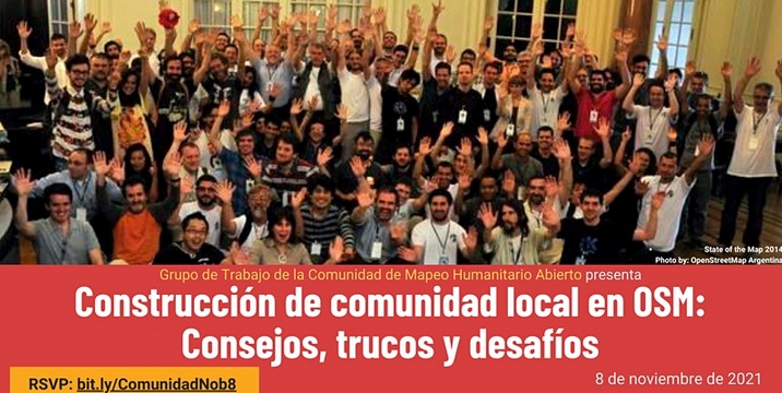
Yesterday, November 8, the event Local Community Building at OSM: Tips, Tricks and Challenges was held, organized by the Hotosm Community Working Group for Spanish-speaking OpenStreetMap communities.

As in any event worth its salt, there is a Document -in Spanish- with the notes on the presentations, conversations and chats, in addition to the video, of course (the video is -again- in Spanish).

I used the aforementioned document to make a live tweeting of the event from the @esopenstreetmap Twitter account, and then it occurred to me to make a thematic summary of the event based on the same notes, in order to facilitate the generation of future actions by the leaders of the communities. That summary is what I present in this post.

Topic Brief: Building Local Community in OSM

See full entry

Location: Unidad Vecinal del Rimac, Rímac, Lima, Province of Lima, Lima Metropolitan Area, Lima, 15025, Peru
Posted by Nicxon Piaso on 8 November 2021 in English.

It’s great to see Users doing OSM editing for Humanitarian use. I live in a Highlands area prone to Frost, and droughts for longer period causing havoc to communities.

I hope to see Relief agencies using our OSM Maps for providing assistance during time odf disaster. Thankyou you OSM, if it hadn’t been your key role in providing open-sourced maps, I don’t think Government agencies will be willing to provide maps to its citizens during times of great need.

Government agencies and Departments don’t provide maps readily and would often come at cost which some can not really access it readily for their use.

I really appreciate the effort by the Developers of OSM and the selfless devotion in creating new features for all Mappers around the world to work on this vital platform for common good for humanity.

Thanks all and happy mapping form Papua New Guinea.

Location: Rungutenges, Kandep District, Enga, Highlands Region, 657, Papua New Guinea
Posted by O J on 6 November 2021 in English.

TrackExplorer

TrackExplorer is a solution based on the idea of RaceDirector. The difference is that with TrackExplorer you can use any GPX file - with or without timestamps. You can choose different activities and no matter where on earth you have recorded GPX data, the data can be displayed in an 3D environment.

TrackExplorer Quick Overview

Via the website TrackExplorer Upload you can easily upload any GPX file. If your GPX file does not have a timestamp, you can decide during the upload the speed your data should be displayed in TrackExplorer. This is necessary if you create the GPX file with a route planner – in most cases there are no timestamps available. TrackExplorer offers different activity categories. Depending on your selection, your uploaded GPX data will be displayed with your chosen activity.

TrackExplorer Activities

Bild

See full entry

Location: Katastralgemeinde Innere Stadt, Innere Stadt, Vienna, 1010, Austria
Posted by Komadinovic Vanja on 4 November 2021 in English.

create new app ( osm.org/oauth2/applications/new )
set callback url ( must be https if not 127.0.0.1 )
client id and secret will be presented ( secret only once )

to obtain authorization code from browser go to
https://www.openstreetmap.org/oauth2/authorize?client_id=<Client ID>&response_type=code&redirect_uri=<Callback url encoded>&scope=write_api%20read_prefs%20write_notes

when user authorize access callback will be called like
https://localhost:7077/oauth2/callback?code=<Authorization Code>

exchange Authorization Code for access token, POST
curl -d "" 'https://www.openstreetmap.org/oauth2/token?grant_type=authorization_code&code=<Authorization Code>&client_id=<Client ID>&redirect_uri=<Callback url encoded>&client_secret=<Client Secret>'

access token will be returned as json, use it for API calls
curl -H "Authorization: Bearer <Access token>" 'https://api.openstreetmap.org/api/0.6/user/details'

resources to read:
https://aaronparecki.com/oauth-2-simplified/
osm.wiki/OAuth

Posted by grin on 3 November 2021 in English.

Real Time Kinetics (RTK)

For half a year now I’m walking, biking and generally moving accompanied by an uBlock F9P unit, which is a precision multichannel GPS receiver board with an external antenna and bluetooth connection to my mobile phone. The phone receives correction stream (NTRIP) by mobile net and uploads it to the unit, which in turn uses the correctional data to fix up atmospheric noise in the GPS signal.

The result is a GPS position way more precise than a phone.

There are 3 usual states:

  • RTK - or “Real Time Kinetics”, when there is both satellite and internet data is available, and the base station of the stream is near. It means precision between 50 centimeters up to 5 centimeters! Imagine it like not only it’s visible when I go to the other side of the path but the track even show when I turn around, since my backpack makes a 30 cm circle around. :-)
  • FloatRTK - is when the precision “floats” from a known-good position, which in practice mean 1.5 meters up to about 90 cm (on average 1 m). When I am within 100-300 km of a base station and I’m moving in a forest this is the most usual state.
  • DGPS - when there is no RTK fix (usually due to no mobile network or blocked satellite receiving) the “normal” differential receiving mode is active, which means 3m - 1m precision, closer to 1.5 m on average, thanks to the external antenna and multichannel receiver.

When I am on FloatRTK or RTK it’s amazing: it can get back to the same position everytime, later on the day, or on a different day, which basically mean that the position is exact. I can draw a track with 50 cm precision and try not to draw that much detail on OSM (not to make anyone mad seeing fixes of centimeters along :-)).

See full entry

I’m editing OSM with JOSM for many years now. After so many years, the UI of it is still something that kinda throws me off, it feels quite clunky at times, not all icons do make as much sense, and it’s not consistent with other editor tools.

But what kinda grinds my gears, is that after so many years, it still can’t do hardware acceleration.

Yes, I’m an nVidia pleb, but it’s something I feel like I must roll my eyes round every time I use this. Given a fast enough CPU it at least still works, but having more complex graphical things work better in a browser, is kinda saddening.

On one hand I feel kinda entitled to tell people to “fix it”, but then again, I should probably look into it myself, I don’t know. I think it’ll be next to impossible to fix anything in JOSM. Last time I’ve checked, the codebase is a little all over the place. That, and it’s also just too big. But there are a bunch of things that I’d like to have changed, I guess. On the other hand, iD is also quite annoying at times, but fixing tags presets with it, is whole lot more convenient than in JOSM.

Perhaps one day, the Java gods will have mercy and fix JOSM for us…

In San Francisco, several roads are marked as having sidewalks, which is normal and good. But I notice some (like Van Ness Avenue here) are marked with foot=yes as well. Even though you clearly shouldn’t be walking around in the actual busy street.

This seems pretty wrong? Being marked as having a sidewalk should be enough for routers. As a bonus, the sidewalk is double-mapped, and Van Ness should be marked sidewalk=separate, I think.

I see a lot of this in SF, which is why I’ve been hesitant to fix it. But I can fix this, right?

Location: Nob Hill, South of Market, San Francisco, California, 94109, United States
Posted by DUGA on 29 October 2021 in English. Last updated on 10 July 2022.

Maybe someone is trying to steal the name here by deleting and readding things at the same time. They have similar profile descriptions almost can be identified as fake/illogical. They share similar behaviors and may even be able to write a diary.

However, they have received blocks in the history:

osm.org/user/NorthwestPAmapper (we caught this account churning in Maryland by deleting a whole shopping mall with surrounding area and failed to readd back after 3 days).

osm.org/user/theurbanexploringman

osm.org/user/buildingroadfixer12

osm.org/user/ZenithTheFox

osm.org/user/Jakethedog2004

I assume that some laymen residing in that area are willing to join and improve the project, but the repeated similar behaviors prompt me to believe that it is abnormal.

If anyone above thinks that you are being offended, please reply and tell us why you keep churning. Seriously speaking, I wish to know the benefits as well!

Location: Waterford Township, Erie County, Pennsylvania, 16441, United States
Posted by Kento Kei on 29 October 2021 in English.

For months now I’ve been wanting to properly do the Zoning and Land use of Madison county, but I’ve finally got around to doing it. I plan on beginning with farmlands around the northern half of the county in order to fill up a lot of the empty space. I do hope that once I begin to add in residential, commercial, industrial, and retail areas into the metro east, More people would begin to add things in the region, seeing I want to get the region to be more active by adding things that people would not really know how to do first thing.

For folks who would want to add some road names in Klang Valley, we have an interesting maproulette challenge for you! These are for mappers who are a little experienced. Here’s where you can get started: https://maproulette.org/browse/challenges/23131

image

Put your mapping hats on and let’s do some mapping!

We would love to hear your suggestions and feedback on these tasks so that we could better next time.

PS: Can’t wait to see who is going to be on top in this challenge (psst.. We have some goodies for you) 😉

Happy Mapping!

Posted by SK53 on 26 October 2021 in English. Last updated on 7 November 2021.

A few weeks ago TrekClimbing asked on talk-gb about tagging various types of vegetation. He has documented some of the more problematic ones on the wiki.

The usage of natural=heath in the UK has not been particularly consistent, and his examples confirmed this. The situation is not helped because large swathes of natural=heath were added by a single mapper. Although doubts were expressed at the time, no-one was confident enough to say that such mapping was wrong.

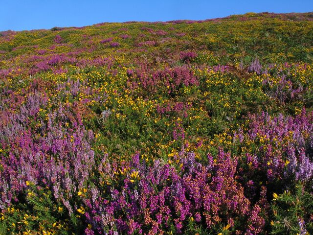
Classic dry heath at South Stack, Anglesey Colourful late summer heath at South Stack

I have been aware that in upland areas of Great Britain natural=heath includes things I would describe differently. Notably these include : upland acid grassland used for rough grazing (mainly of sheep) and blanket bog.

It occurred to me that by comparing OSM data with another source would quantify this impression. Fortunately, a suitable source exists for Wales: Phase 1 habitat data.

See full entry

Location: Betws Garmon, Gwynedd, Wales, United Kingdom
Posted by Mordechai23 on 26 October 2021 in English. Last updated on 4 July 2022.

This is a collection of gifs illustrating the process of me and other mappers redrawing landuse, buildings, paths and other objects in my home city - Wrocław

Most gifs represent the state of OSMcarto immidiatelly before and after the main bulk of my edits in the area and thus may not include later changes made by me or other contributors

Current goal is to revise the core city centre of Wrocław and then possibly other densely populated areas. I focus on realigning and correcting the geometry of existing buildings and adding missing footways, driveways, green areas and landuse, while ignoring the City’s street grid and POIs

Those edits are mainly based on areal photos from 2018 and 2021, complimented by photos from fotopolska.eu and of course my own observations made while strolling around ;)

Why?
  • First of all, before my edits there was next to none landuse in the city centre and not much more in the suburbs.
  • Secondly, most of buildings here are remnants of an old, poorly executed import and are often misaligned, crossing each other or were simply demolished since 2011. Some buildings were broken down into small parts without using building:part tagging
  • But most importantly, we’re observing a big influx of new users contributing via StreetComplete and other similar tools. Those users often edit the old, problematic buildings, with huge issues with geometry, potentially causing problems later. By replacing those, I try to provide more meaningful challanges for those users to complete ;)
Progress (finished 04.07.2022): 149/149 areas, 100% done 🎆

See full entry

Location: Four Denominations District, Stare Miasto, Wrocław, Lower Silesian Voivodeship, 50-073, Poland