Diary Entries in English

Recent diary entries

Posted by syntex on 13 July 2021 in English. Last updated on 27 July 2021.

Origins:

Since the 31st of August 2020 a huge polish government database BDOT10k, which contain a lot of useful data is publicly available and also can be used for the purpose of OpenStreetMap. The quality of the data varies depending on the region. Nevertheless, the quality of the buildings in this database, especially in the city of Warsaw is quite astonishing. That is why I decided, that we should make use of this data and implement it, especially that the existing buildings in OpenStreetMap in some districts of the city are just awful, made 5 or more years ago on Bing satellite imagery.

The process:

This is not an automated process, every building is reviewed one by one MANUALLY and that is why it takes so much time. I also turn on the EGIB database in JOSM, to verify the shapes of buildings and also to add smaller ones like sheds, because the BDOT10k does not contain buildings smaller than 40m2. Some detached houses, that are abandoned, also do not appear in the BDOT10k base. I do not delete building that are almost ideal, it doesn’t make any sense. I only copy the data about the purpose of the building and the amount of floors from the BDOT10k and I add it to the existing object. It makes this entire process even longer, because you have to be also a quality controler : )
And the most important, a huge thank you to tomczk known on discord also as Tomek | budynki for creating this incredible tool budynki which made the process so much easier, than manually downloading the BDOT10k data from the polish government websites. It enables downloading objects from a particular region, you do not have to download data package that contain for example the whole city or the whole “gmina”. This tool also translates all these objects from the governmental language to a OSM tags language : )

Reasons why?:

See full entry

Location: Żelazna Brama, Śródmieście Północne, Midtown, Warsaw, Masovian Voivodeship, Poland

My intention

It is what it is. This is some feedback for the organizers, speakers and community at large. I’m just picking out my main impressions and experiences. I sat through about 80% of it except for a couple of the Sunday things. The conference, being the second remote one had a dead atmosphere about it, even judged by the remoteness yard-stick. I have always been remote, for various reasons, and I enjoyed Japan, Milan, Heidelberg, and even the shell of Cape Town last year from afar. In those years small glitches occured, but despite these things did improve and did get better with the passage of time.

My intention is to give positive feedback, without being a cheerleader because cheerleading is just noise, not specific and not credible. Positive feedback is honest, and helpful with its honesty.

The content

I think the speakers, their topics, the content decisions, the preparation, the enthusiasm and the concern for the rest of the community and the project shown by the speakers was exemplary. As a viewer of several SOTMs I can certainly see interests in the community maturing, specializing and upping its game in terms of evidence behind ideas, and explanation of these ideas, and calls for engagement. I don’t dare to pick out my favourites as I have 4 friends who presented, but there were talks that were surprisingly interesting, beyond how they were billed. This needs to be preserved, firstly by naming it for what it is, and maybe the process of selecting and focusing talks is working well.

The format

See full entry

Posted by moithil on 12 July 2021 in English.

Dholburu is located near the Gajaburu hills in Purulia, Bengal.

Drinking water: Parkidi village. There are ponds around the camping ground. Food: Parkidi village has people to offer food other other catering services, inlcuding cooked food, water, tent house equipment, etc.

The place is suitable for rock climbing and hiking. Hikers can get into the Ayodhya range from this location.

How to reach Esplanade - Jhalda route buses pass through the nearest point to this place.

Perfect place for camping if you get catering support and permission from parkidi.

Location: Arsha, Purulia, West Bengal, India

Hello everyone! I would like to make an update on my project “Nominatim QA Analyser Tool” which is progressing very well.

As a recap, this project aims to have a tool capable of analysing the Nominatim’s database to extract suspicious data from it. Then, these data should be presented to mappers through a graphical interface so that they can correct them.

Github repository

The tool is still under development, it lacks of tests, documentation, configuration etc. However, you can access the github repository there if you are interested: https://github.com/AntoJvlt/Nominatim-Data-Analyser

Suspicious data public visualization

We chose to use Osmoscope as the main visualization tool for the data we extract with the Nominatim QA Analyser.

I have setup up an instance of Osmoscope on the development server which was provided to me for this GSoC project. This instance is publicly available there: https://gsoc2021-qa.nominatim.org/osmoscope You are free to look at it and start fixing some data errors around you!

/!\ Here are some important informations to know about this public instance /!\

  • The OSM data on the development server are not regularly updated. The current OSM data were imported around May 24th 2021.
  • This is the osmoscope instance that I use for the development, this means that it can be down or data can be under some tests at some point so it is not fully trustable.
  • If you want to follow the evolution of this Osmoscope instance throughout the development, dont forget to refresh your browser’s cache for this webpage to get the latest evolutions.
  • The QA rules are not definitive, if you find data that you think are not wrong or if you want to discuss about the QA rules, please come to the Nominatim’s github page in the discussions section. QA rules suggestions are also welcomed.

How does the Nominatim QA Analyser tool work

See full entry

Location: Cité Emile Zola, Orléans, Loiret, Centre-Val de Loire, Metropolitan France, 45000, France
  • Over the course of June, I came out 🏳️‍⚧️. 😊😊 Everyone’s been really great about it. In OSM, we map things as they really are, regardless of how they were used in the past, or what the government assigned it at the start. But, you know how much work is involved in deprecating a previously used tagging scheme. You need to find all data users, and update them to the new scheme.

  • CWG
  • Debugged an issue why someone couldn’t post to the diversity-talk@ list (which I co-mod)
  • OSMF Board
    • Possible relocation of OSMF from the UK
      • Ireland?
        • ½hr phone call with Irish lawyer about Irish legal structure
      • Advisory board
        • email AB to ask if can move to your country
        • emailed AB about what type of corporate structure would help them give us money.
    • Attribution Guidelines
    • AOSMFBAAAoAAAA
      • email osmf-talk & board@ to tell them
    • Bank account
      • posted signed forms to again
    • Advisory Board Meeting
      • created doodle & emailed AB
    • trademark grant request (OpenSnowMap)
      • Recieved, but we probably need a board resolution

Previously:

2021: Jan. Feb. Mar. Apr. May 2020: Jan. Feb. Mar. Apr. May June July Aug. Sept. Oct. Nov. Dec.

Posted by mariotomo on 10 July 2021 in English. Last updated on 13 July 2021.

Speaking of inclusion and participation, I do have an idea why nobody from rural Panama participates to OSM. Mind you, I’m not saying “almost nobody”, but “absolutely nobody” . . . the point is, as most Third World countries, Panama has a failing . . .

I hear voices calling to order, you say that calling Panama a “Third World country” is offensive? Oh, the very use of the concept? I should say “Developing Country”, right, nice, very politically correct. But calling it as you suggest, that’s not political correctness, it’s a lie, in my opinion it’s a lie needed when we don’t want to accept the fact, and to deal with it. So please let me insist:

. . . in this Third World economy, infrastructure suffers from low or absent public investment. We have here a long lasting rain season, from May to November, and in the rural area power fails generally a couple of days per week, may last a couple of hours, or more often until the next morning. In such condition, I still assumed I would be able to follow if not participate to the venueless SotM-2021, as I did last year from a hammock, on a 10 years old tablet, using solar power and a couple of batteries.

We are at this hotel, a beautiful place, in the middle of their own land recovery project, and because of the cloud cover their “high speed” link disappeared (one of the towers must have a power failure, not compensated by solar power), so we went to a different location within the recovery project, a higher located building where you put the phone on the roof, in a waterproof bag, and have “3.5G” from an antenna at 10km. With high humidity and low hanging clouds it may drop to 2.5G, “waiting for network” half of the time. This was less convenient than last year, mostly because I could not use my hammock.

See full entry

Posted by Kilkenni on 10 July 2021 in English.

I rarely visit the forums these days. Between real-life issues, activism, studying and work, on the case when I have a few minutes to map I do exactly that. Silent mapping. Probably what many of us do.

Apparently, this was not meant to last.

Recent events with bans of Ukrainian users seem to clearly violate the Ban Policy, and from what I’ve seen, DWG can’t (or doesn’t want to) provide a reasonable explanation. It remains a “closed circle” with zero transparency. Usually I’m fine with that. I can’t fix all the things in the world, so it’s about priorities. However, this particular case seems serious enough to break my seclusion.

I could present it as bias or discrimination (as I probably should), but as the discussion about the issue in our Ukrainian community progresses, I came to understand it had more serious implications than merely suppressing people from a certain group.

From what it currently looks, DWG is currently trying to play thought police and persecute people for the content of their OSM profiles based on personal opinions of DWG members. In doing so, DWG is overstepping their borders and misusing their power.

We came to think that OSM is community driven, and all the overarching structures are in place for our convenience. However, if anyone can be expelled and permabanned (to be more precise, banned for 10 years) from the platform without clear ramifications and rules of dispensing these bans, it is the beginning of the end. This threatens the future of OSM project as a whole, a tangled community I am fond of.

I will try my best to spare time and go into details as we struggle with finding a reasonable solution that will benefit OSM and hopefully prevent any future issue of this kind from happening. I will also try to avoid calling names at this time as I’m still studying the situation. I am hesitant to point fingers unless having solid understanding first.

Introduction

Hi everyone! As the first evaluation period is closing in, I am writing this diary entry as an update on the progress of my GSoC project for OSM, the OpeningHoursEvaluator.

Using the test-driven development approach (which, by the way, works wonderfully with this project), suggested by one of my mentors, Simon Poole, my project OpeningHoursEvaluator, an evaluator for the opening hours tag defined by OSM, is progressing fairly well, with the evaluator supporting almost all the syntaxes defined by the specifications, ranging from something as small as time and a wider range such as year, except for certain syntax where the OpeningHoursParser have yet to cover, variable time (dawn, sunrise, sunset, dusk), and also country-specific public holidays and school holidays (PH, SH). This is something I intend to complete in the second period of GSoC.

Current project location

GitHub repository: https://github.com/goodudetheboy/OpeningHoursEvaluator

Timeline

See full entry

Posted by Yunzhi on 7 July 2021 in English.

At Facebook, we’ve been releasing our Daylight Map to the public since March of last year. Daylight is a version of OSM that has been quality checked and validated to ensure that the resulting map is safe and of high quality. It is the map data that is used on Facebook maps. Our goal is to make OSM easier and safer to use which will then expand the use of OSM.

When building Daylight, we employ automated validation processes to find bad data. That bad data is then either deleted from the map or corrected in the OSM database. This diary will go over the map validation efforts we’ve made to the map to make Daylight safe to use.

The map validation efforts includes three parts: vandalism and profanity cleanup, relation repair, and Atlas Checks fixes.


Vandalism and Profanity Cleanup

In the last couple years, our engineering team has spent a lot resources to research how we can identify vandalism and profanity more systematically and more accurately. With these improvements to our detection tools, we were able to fix over 360 examples of vandalism and 16 instances of profanity on feature names all over the world.

See full entry

Posted by xyzl on 7 July 2021 in English.

A number of areas in the UK (and the world) have painted crossings in LGBT+ pride rainbow colours to support LGBT+ rights.

In the UK at least, these are often referred to as ‘rainbow crossings’. They don’t always look the same, with some using different colours/pride flags.

Image of two rainbow pedestrian crossings next to each other with a pedestrian island separating them, the lines of colours are oriented so that they are horizontal, similar to an LGBT flag, from the point-of-view of a driver, or vertical to someone crossing the street Image of rainbow crossing by Matt Brown used under Creative Commons CC-BY-2.0 license.

Here’s a recent example from Bristol, a city in the South West of England: https://www.bristol247.com/lgbtq/news-lgbtq/bristol-gets-its-first-rainbow-crossing/ .

Here’s two in a London borough: https://www.richmond.gov.uk/first_rainbow_crossings_unveiled

and another: https://www.bbc.co.uk/news/uk-england-london-51446121

one at Surrey University: https://my.surrey.ac.uk/news/introducing-our-new-rainbow-crossing

And here’s one in New Zealand - https://en.wikipedia.org/wiki/Cuba_Street_rainbow_crossing

See full entry

Posted by PkBuzios on 7 July 2021 in English.

Seale-Hayne Seale-Hayne is a former university located in Devon, UK. It was one of the first purpose-built agriculture colleges in the country, the foundation stone was laid back in 1914 and the construction finished in 1918 when the site was lent for the army to treat shell shock victims from the first world war and in 1920 it would finally receive it’s first agriculture student. The university functioned until 2005 when it was closed and the site was sold. Today it functions as a business centre, hosting different business and charities offices, artists studios, a well-being centre with a pool and a café. It still has a active alumina community which maintains a Heritage Room with objects from the university’s time.

I spent last months slowly mapping the place, adding buildings, names, paths and a few of the business. With the help of StreetComplete I could add a lot of detailed info such as number of steps, building floors, surfaces, etc.

See full entry

Location: Seale-Hayne Business Campus, Newton Abbot, Teignbridge, Devon, Devon and Torbay, England, TQ12 6NQ, United Kingdom
Posted by Kento Kei on 7 July 2021 in English.

I’m about to begin working on mapping out every building, Business, and missing information to Wood River and Bethalto.

Currently I’m going to switch between working on Wood River, and Bethalto, mostly focusing my efforts on getting zoning areas and buildings in place. Thus I will follow those by adding the smaller details, like shop names, addresses, and trees.

Posted by matheusgomesms on 6 July 2021 in English. Last updated on 7 July 2021.

Visualization of vaccination posts in Fortaleza

(original post in Portuguese here)

Introduction

In the last weeks I focused my efforts on adding vaccination facilities in Fortaleza/Brazil. At the moment of writing, there are in Fortaleza exactly 113 vaccination sites, being (if I’m not mistaken) 100 clinics and 13 other places (such as shopping malls and huge infrastructures like a stadium and convention center).

The method I used for this was to use the open data of the Fortaleza City Council (don’t worry, dear warrior of licenses, we have explicit permission for this) for the locations and details of the clinics, along with the other 13 locations that have been manually updated.

Methodology

Preliminary Step

See full entry

Location: Meireles, Fortaleza, Ceará, Northeast Region, Brazil

My April 2021 in OSM

(Sorry for the delay, I’ll try to catch up, which might result in less detail for this month)

Previously:

2021: Jan. Feb. Mar.

2020: Jan. Feb. Mar. Apr. May June July Aug. Sept. Oct. Nov. Dec.

Posted by sjorford on 6 July 2021 in English.

Things I’ve done recently:

  • Renamed a couple of new roads in Congleton - the new “Back Lane” is now Somerford Lane, and what was labelled “Viking Way” is actually Barn Road all the way to the bypass, confirmed by a new road sign at the north end (Viking Way is actually just the short road leading to the Airbags plant)
  • Surveyed some of the shops in the town centre to see what has changed in the last year
  • Named a couple of localities, namely West Heath, Mossley and Hightown - I’m not entirely clear where they should be placed but they’re on the map at least
  • Extended the Mersey Valley Timberland Trail between Runcorn and Warrington - this was partially mapped as two separate relations which I have merged
Posted by DeBigC on 5 July 2021 in English.

This diary post is a follow up on the one I did last week here where I was looking at how much, and for what the Ireland OpenStreetMap community uses the StreetComplete(SC) app.

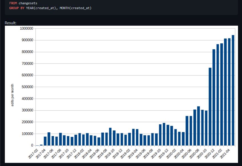
The StreetComplete creator Tobias replied showing an interesting worldwide trend for SC usage. The trend here shows that there has been an upturn in SC usage worldwide in the last couple of years in terms of the users and edits contributed:

changesets.jpg

In particular Tobias shows that co-incidental with the Covid-19 months that there was a big upturn in the changesets contributed, starting gradually in May 2020 with a doubling on the previous month, but continuing to rise until the changesets remained at about 4 times the normal level for the forthcoming year. Most users are in the Northern hemisphere, so to see the higher level of changesets sustained through the Northern Hemisphere’s winter months is impressive.

In Ireland the changes, as in the big upturn are also reflected in a little bit of analysis done here.

See full entry