Diary Entries in English

Recent diary entries

Posted by c tito young on 22 March 2021 in English. Last updated on 10 April 2021.

A geoglyph of a straight snake (100m long x 5m wide) oriented from northeast to southeast shows it in a side view and an open mouth with its belly facing north. It is unclear why the snake is there or why its mouth is open .

14°48′36″S, 75°20′51″W -14.8100834, -75.3476308 Changuillo, Province of Nasca, Ica, Peru

Location: Las Brujas, Changuillo, Province of Nasca, Ica, Peru
Posted by bo_hot on 22 March 2021 in English.

So, over at HOT_tech we’ve we’ve been working hard, so you can work easy. Our number one priority is hearing and helping, so we’ve made some changes to make it easy for you to notify us of bugs, issues and support requests.

All roads lead to…’hot_tech_requests’

We know that everyone likes to communicate in different ways; slack, email, online forms etc and we don’t want to change this. We want to meet you where you are. However, we also want to make sure that no request is left behind. As such, we have established a service desk that brings your request from where you are, to where we are - the hot_tech_requests desk.

So how does it work?

  1. You send us a message however you want.
  2. That message gets added to our service desk backlog (and you get a nice message to say ‘thanks’)
  3. We work to resolve it
  4. You get updates on how it’s progressing and when it’s done.

Raise your voice by raising a ticket and make sure that your voice gets heard and your ticket attended to.

So how do I do it?

Well, glad you asked, I was just about to mention. Everything can be done in three steps or less.

The hot_tech_requests desk (rapid response, requires email for updates)

  1. Go to hot_tech_requests desk >
  2. Select your issue and complete the form >
  3. Done >

You will be automatically updated via the email address you provided

Shout out on Slack (regular response, requires slack membership)

  1. Go to this channel in hotosm slack > #hot_tech_requests
  2. Type a message related to your issue.
  3. Done!

Issue updates will be posted directly to this channel so everyone can see the progress.

Send an email (regular response, no sign-up required)

  1. Email this address techsupport@hotosm.org
  2. Done

You will be automatically updated via the email address you used to send the request

GitHub (regular response, included in backlogs, github account required)

See full entry

Location: Naz, Esserts-Salève, Monnetier-Mornex, Saint-Julien-en-Genevois, Upper Savoy, Auvergne-Rhône-Alpes, Metropolitan France, 74560, France

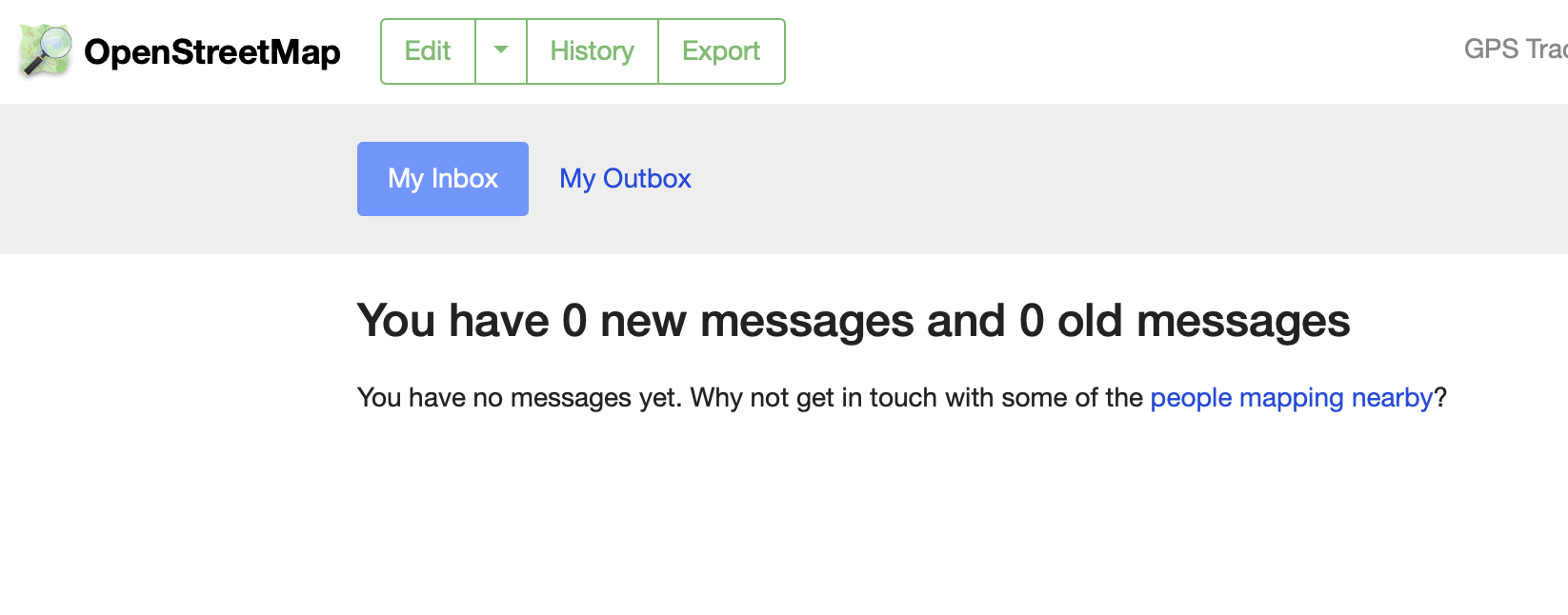
If you’ve ever wanted to help build the OpenStreetMap website but found our codebase intimidating, you’re in luck. With the recent addition of Jamie Alessio’s Docker support in pull request #2409, it’s now easier to contribute well-tested changes to the OSM site. I’ve never been comfortable with Rails, Chef, or other Ruby code like the kind we use to build OSM.org. Many helpful changes to the site can be made with small front-end tweaks in just HTML or CSS. The new support for Docker provides a quick way to install a working version of the OSM site on your local computer and preview changes before you contribute.

Here’s a recent change I made to implement Andy Allan’s suggestion for improved inbox/outbox navigation, using Bootstrap navigation tabs in place of plain links. This small design tweak is now live on OSM.org My Messages:

new Inbox image

Contrast this with the old look, with simple HTML links in the page header that don’t quite look like usable navigation:

See full entry

Location: Downtown, Downtown Oakland, Oakland, Alameda County, California, 94612, United States
Posted by c tito young on 22 March 2021 in English. Last updated on 10 April 2021.

A geoglyph pointing southwest is of a bird in flight (50m x 50m). The sideview shows the body with a tail, one wing and one eye, and a beak. Below the bird is another geoglyph (25m x 5m) but very hard to tell what it is, pointed in the same direction. He is drawn on the tip of a bluff and likely visible from the ground or sky.

14°44′24″S, 75°12′27″W -14.7400748, -75.2074830 El Ingenio, Province of Nasca, Ica, Peru

Location: El Ingenio, Province of Nasca, Ica, 11350, Peru

The Proposal

In late 2020, I drafted a proposal to introduce a common format for the name=* tag in the Republic of Srpska, a territorial subdivision of Bosnia and Herzegovina (BiH). The reasons were mainly general data inconsistency and recurring edit wars. There are two official scripts in the Republika Srpska, Latin and Cyrillic, both of which are in active use. Moreover, some mappers (as well as members of the general public) consider the usage of either or both of the two scripts a political tool and/or an instrument of nationalist propaganda. This means that it is hard to reach a consensus as to what the name=* format should be. It can be argued that a tag like name=Бања Лука is violating the On-the-Ground Rule because both scripts - not just Cyrillic - are official. It can also be argued that a tag such as name=Banja Luka / Бања Лука violates the OTG Rule because the city is not called “Banja Luka Slash Banja Luka” or because one of the scripts is “more official” than the other and should therefore be listed first. Therefore, I included several possible name formats in my proposal and invited the members of the OSM community in BiH to vote for the most suitable one with the intention to propose the winning format “officially” to the worldwide OSM community. The voting took place on the proposal’s discussion page.

The Response

I have contacted 55 mappers in total, most of whom were my saved private message contacts with whom I have corresponded over more than 4 years of consistently reaching out to BiH users, others were top-ranking mappers recently active in the country. As you can see on the proposal discussion/voting page linked above, the response was rather underwhelming, with many of the most active users ignoring the communication and the vote completely.

See full entry

Posted by SekeRob on 20 March 2021 in English.

After doing this intensely for 8 months, constant COVID-19 lockup, it’s depressing how poor the quality, but foremost the tag completeness is. At times it’s like boxcars. There’s many who never seem to follow up on their issues left behind, unconnected ways, routers, they don’t understand 2 end nodes 1 meter apart… there’s no way for them to go from one to the other. We plod on though and keep witteling away at it. Both the navigators I use are OSM data based so whatever I can resolve along the ways I traverse, helps me plotting the next long distance cycle tours in particular… is it up or down, the angle, what quality is the surface, yes here in Abruzzo it’s not a given, many cracks and potholes… cost me 2 wheel rims already so recently switched to 2.5 inch wide rubber wheeled bike… much more conformable. Keep going.

HOT is setting up a new regional hub structure globally (see previous posts), and with the two new hub directors Nama Budathoki (Regional Director: Asia-Pacific) Monica Nthiga (Regional Director: East Africa), and Head of Community Pete Masters we’ve been pondering what they should be called.

Why is this important?

  • We want to signify some of the values of what the hubs should be in the name, to signal what a hub stands for. The name should indicate that it is an open and participatory space for communities to engage with. More on hub principles here.
  • We also need to communicate what the hubs do not stand for; that this is not a HOT country office, nor do we want it to be.
  • The hub work is only just beginning; now is a great time to choose a name which indicates what the hub could be for communities that have not yet engaged with OpenStreetMap at all. The name should help connect these communities with what to expect from the hub.
  • The word “humanitarian” is not applicable to all of the locations and contexts the hubs serve, and does not resonate with many OpenStreetMap communities globally. Using HOT’s acronym could be useful to signal that the hubs are related to HOT, but the word humanitarian may be less so.
  • Building awareness is really hard, and so it would be easier if the hubs share a commonality in their naming, that is, we don’t have four different hubs with four completely different names

What’s not possible?

  • Several people have suggested we could use OpenStreetMap hub or OSM hub - unfortunately that’s not allowable under the current trademark agreement that’s coordinated between the HOT & OSMF Boards.

Idea for a formula:

What do we need to include?

  1. The region (Asia Pacific, East Africa, West Africa, Latin America & Caribbean)
  2. A link to HOT; how do we identify these open mapping spaces are supported by HOT?
  3. Something about the nature of the space; what is it?

Some examples of ideas (using Asia Pacific region as an example):

See full entry

Location: Crystal Palace, London Borough of Bromley, Greater London, England, SE19 2GA, United Kingdom
Posted by joost schouppe on 16 March 2021 in English.

The reason I’m writing this post is that my first MapComplete theme got merged into the official version. Yay! But first, an introduction.

Introduction

Having been freed from most OSMF duties, I got a bit of an OSM reboot as of late. I became more active in Belgium, where OSM seems to be booming. More people want to be involved, many more people care about what is on the map.

One of the projects that have made this a fun time, is MapComplete. I was always very enthused by projects like MapContrib - because they make it easy to create detailed thematic maps, while also being an editor for that specific theme.

I really believe thematic editors are the way forward for OpenStreetMap. Most of us here are people who care about “the map in general” (or at least a wide range of mappy topics). But most “normal” people don’t care enough about OSM data to invest in learning to use a fully fledged editor. Yet they might care more about data they really need - like whether they can store their bicycle safely, or if the power outlet is right to charge their car. Or they might be passionate about certain topics, like accessibility of paths in their neighborhood, public fruit trees, handicapped parking spots.

MapComplete is built to bring those people to OSM, instead of the plethora of POI databases that exist today. If you want to introduce MapComplete to non-OSM people, have a look at the project page on OSM.be (en, nl, fr). The project was started by PieterVDVN for a project to map the accessibility of neighborhood nature. During Open Summer of Code we expanded on it for the Brussels Region. Flemish municipalities are interested in it as well.

See full entry

Posted by ottwiz on 16 March 2021 in English. Last updated on 25 March 2021.

Rákospalota sometimes has dumb addressing like

Sződliget utca 30, 34, 32, 36

or Mátyás utca 64/a 64/b 64 64/c

Aporháza utca 13-15, 13, 17, 17-19, 19, 29 (i mean, what the hell)

and i could list it all the way along, but it wouldn’t make any sense. Also, the area has outdated imagery, today I discovered there is a dog park behind Énekes utca 19-35 apartment block, which is not on neither of the imageries available here, because it’s so new. I mean, I made a lot of photos for surveying purposes but I wish there was a 2020 imagery in my area. I think i’m mostly done with my area, it was a VERY hard work, and there is still housenumbers missing in the 15th district, but because of me, i did around 25-30% of it, and I’m proud of it. :)

Location: Rákospalota Öregfalu, Rákospalota, 15th district, Budapest, Central Hungary, Hungary

Ride sharing for “Mapillary Street Level Imagery” & “KartaView” in Shkoder County (Albania)!

Data Collection - Data Processing - Data Presentation

OpenStreetMap is a community project which requires so much time to invest in the mapping process from OpenStreetMap. Nowadays, with the rapid change of the cities, people are demanding more and more for digital information. Digital cartography plays an essential role in various areas of digital cities.

Even though many of us use directly and indirectly the data from OpenStreetMap, there are still people that do not know where the data come from. Without this community, OpenStreetMap cannot exist.

I chose Shkodra and the surrounding area of it as the first area to develop this project. Why Shkodra? Because Shkodra is my hometown and I still live there. Some years ago, I started editing a very detailed OpenStreetMap in Shkodra.

In attempting to provide different grant projects for OpenStreetMap and HotOSM and etc., I have not been successful. For a couple of months I have been trying to create mapillary imagery photos myself using mobile phones.

Data collecting by “Mapillary Street Level Imagery” & “KartaView” is a simple process that simplifies editing in OpenStreetMap with JOSM from anywhere. Here I am now. To the next step of data collection. “Mapillary Street Level Imagery” & “KartaView” is a service available to the community.

I am askin everyone in my area, in Albania / Kosovo and everyone who is on the road in Albania, if you want to contribute to using your mobile phones for mapillary/kartaview imagery, please send me a text message. Almost every weekend, I choose a route in and around Shkodra.

ps. OpenStreetCam is now KartaView!

Posted by landscapemapper on 16 March 2021 in English.

I pretty recently started to play table tennis, about weekly against my mate Roman. It is only then I noticed that table tennis tables TTT’s are a real ubiquity, especially on school-yards. Thus whenever you need a break, proceed to the nearby TTT and have fun. :-)

How to find? - I composed a umap containing all OSM mapped TTT’s in Switzerland. ( to date: 1081 TTTs)

See full screen

You can contribute to the collection mapping TTTs and tagging the nodes with leisure=pitch + sport=table_tennis. Here is the according OSM Wiki Page.

These tags are btw. the key to get your own data-set of TTTs over your region from overpass-turbo.eu.

Good spin!

Location: Escher Wyss, Industriequartier, Zurich, District Zurich, Zurich, 8010, Switzerland

I’ve never written a diary post, and for my first, why not write about a quick intro to my first experience of using the Mapillary app?

I’ve always been interested in contributing street-level imagery. I’ve always thought that you would need a lot of different and expensive equipment to do it. Little did I know that there was an app!

Using the app is super easy. I downloaded the app from the google store. I opened the app and chose the “Capture” option. Then, pressing record is all you’ll need to start capturing!

I use a magnetic phone mount on the windshield of my car, so all I had to do was point my phone’s camera towards the road. Now, before you start capturing, you have to make sure that the point of view with your phone’s camera free of obstruction like your dashboard or speedometer. I had to adjust my camera angle a bit to get the best view possible with my setup.

What’s great is that the app automatically pauses, capturing when you’re at a stop. I believe the capture frequency is dependent on GPS signals. You can also tap the stop capture button when you’re all done.

See full entry

Posted by DeBigC on 15 March 2021 in English.

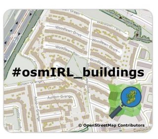
As a Director of OSM Ireland (osmIRL) chapter I occasionally get to do nice jobs for the community. Our chapter received a microgrant from the OpenStreetMap Foundation which we are using in conjunction with the agreed community task to map all 5+ million buildings on the island. With the support of this microgrant the chapter deployed the concept of rewarding mapping landmarks with a small token of appreciation for reaching the landmark of 10,000 buildings.

In this case we are giving our contributors a handy mouse mat, which is made with foam and nylon and carries a nifty design. Bias declaration: I designed it! mouse-matt.jpg

The background image is simply one part of suburban Dublin, showing the importance of adding buildings to the map. It also shows the campaign name #osmIRL_buildings. We have a task manager here to co-ordinate all this work.

See full entry

Location: Kilmore Big, Kilmore A Ward 1986, Dublin, County Dublin, Leinster, Ireland

this is small village near Saleh Bhambro station 🚉 having about 20 houses and well educated people are living. https://goo.gl/maps/hmQZahYWKzLNXBJp6 this is the actual location of this village

Location: Village Bhagat Gajo Kolhi Parmar, Samaro Taluka, Umerkot District, Mirpur Khas Division, Sindh, Pakistan

A geoglyph of a man’s head appearing to be eating a snake (100m x 100m) on relatively sloped land. The man is in profile, facing west and seems to be swallowing what looks like a snake whole. It is unclear what kind object he appears to be swallowing. None the less, this image is rather disturbing.

In very close proximity to this geoglyph is near a flat plateau of what appears (hard to see at this current aerial resolution) of hundreds of images that look like a mosaic of geoglyphs ranging from 3m - 15m. Some look like faces while other looks like animals.

14°46′5″S, 75°11′4″W -14.7681516, -75.1844319 El Ingenio, Province of Nasca, Ica, Peru

Location: El Ingenio, Province of Nasca, Ica, 11350, Peru

As part of figuring out how to best process standard tile layer logs I had a chance to generate some charts for usage of the OpenStreetMap Standard tile layer on the day of 2021-03-14, UTC time. This was over a weekend, so there are probably differences on a weekday. I’m also only looking at tiles delivered and not including blocked tiles from scrapers and similar usage. All traffic is in tiles per second, averaged over the day.

Countries

I first looked at usage of the layer from users on openstreetmap.org and all users, by country.

See full entry