Diary Entries in English

Recent diary entries

Posted by DeBigC on 15 March 2021 in English.

As a Director of OSM Ireland (osmIRL) chapter I occasionally get to do nice jobs for the community. Our chapter received a microgrant from the OpenStreetMap Foundation which we are using in conjunction with the agreed community task to map all 5+ million buildings on the island. With the support of this microgrant the chapter deployed the concept of rewarding mapping landmarks with a small token of appreciation for reaching the landmark of 10,000 buildings.

In this case we are giving our contributors a handy mouse mat, which is made with foam and nylon and carries a nifty design. Bias declaration: I designed it! mouse-matt.jpg
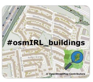
The background image is simply one part of suburban Dublin, showing the importance of adding buildings to the map. It also shows the campaign name #osmIRL_buildings. We have a task manager here to co-ordinate all this work.

See full entry

Location: Kilmore Big, Kilmore A Ward 1986, Dublin, County Dublin, Leinster, Ireland

this is small village near Saleh Bhambro station 🚉 having about 20 houses and well educated people are living. https://goo.gl/maps/hmQZahYWKzLNXBJp6 this is the actual location of this village

Location: Village Bhagat Gajo Kolhi Parmar, Samaro Taluka, Umerkot District, Mirpur Khas Division, Sindh, Pakistan

A geoglyph of a man’s head appearing to be eating a snake (100m x 100m) on relatively sloped land. The man is in profile, facing west and seems to be swallowing what looks like a snake whole. It is unclear what kind object he appears to be swallowing. None the less, this image is rather disturbing.

In very close proximity to this geoglyph is near a flat plateau of what appears (hard to see at this current aerial resolution) of hundreds of images that look like a mosaic of geoglyphs ranging from 3m - 15m. Some look like faces while other looks like animals.

14°46′5″S, 75°11′4″W -14.7681516, -75.1844319 El Ingenio, Province of Nasca, Ica, Peru

Location: El Ingenio, Province of Nasca, Ica, 11350, Peru

As part of figuring out how to best process standard tile layer logs I had a chance to generate some charts for usage of the OpenStreetMap Standard tile layer on the day of 2021-03-14, UTC time. This was over a weekend, so there are probably differences on a weekday. I’m also only looking at tiles delivered and not including blocked tiles from scrapers and similar usage. All traffic is in tiles per second, averaged over the day.

Countries

I first looked at usage of the layer from users on openstreetmap.org and all users, by country.

See full entry

Posted by c tito young on 13 March 2021 in English. Last updated on 14 March 2021.

Geoglyph of a man with a beard (50m wide x 75m long) is of what appears to be a man wearing a cape and poncho traveling east to west. He has and starkly appears to trudge forward. He is drawn from the waist up, but there is suggestions that he is sitting on an animal, but not confirmed.
In front of the man is some kind of etchings, which are evident but indistinguishable at the resolution from this aerial scans. He is drawn on moderately steep land, in a valley between two peaks. It is unclear what he is doing or where he is going.

14°44′58″S, 74°56′32″W -14.7495465, -74.9423362 Nazca, Province of Nasca, Ica, 11401, Peru

Location: Nazca, Nasca, Province of Nasca, Ica, 11401, Peru

Andy Townsend wrote to me “we’d ask you to step back from your self-appointed role as “OSM gatekeeper” in Panama”

now, I have no idea how to stop caring for quality.

only option I see is to stop even looking at what is being added to the database.

someone please shows some support in public, or as said I am short of options.

https://forum.openstreetmap.org/viewtopic.php?id=72158

Posted by qeef on 12 March 2021 in English. Last updated on 15 March 2021.

I’ve been refactoring the Divide and map. Now. last two months. (No surprise, I’ve plan it.) The most beautiful work was done on the server and the database. I will cover that in more technical diary later.

In this diary, I want to summarize how the clients look like now.

Client + panel

Lightweight
client

The (lightweight) client keeps with the common mapping workflow: Map -> Review -> Done. It’s meant to load fast with the minimum data transfer. It tries to avoid rushed clicks of newbie mappers by putting the phrases of “needs more mapping”, “is ready for review” or “split the square” into the sentence. Newbie mappers may click “let reviewers know” as I’ve already wrote.

See full entry

Posted by Supaplex030 on 12 March 2021 in English. Last updated on 25 February 2023.

This post is also available in German / Dieser Post ist auch in deutscher Sprache verfügbar.

OSM parking space data can be a great source of information for the debate around urban development and the transition towards a more sustainable transport system. In many places, there is still no systematic knowledge of where and how much parking is avaliable along the road and beyond. Right now, this data is usually only collected as a part of expensive studies, which are usually not available to the public once they are done. In contrast to this, OSM is an environment in which such data can be freely collected and analysed.

Using the Berlin district of Neukölln as an example, we have demonstrated how urban parking spaces can be systematically mapped using OSM as a basis. We then analysed the collected information at high resolution using geoinformation systems (here: QGIS) and incorporating other open data. This blogpost will give you an overview of the methodology and share some important results and experiences for OSM practice.

You can take a look at the results and data in the Neukölln parking map, where different parking information is visualised, the underlying data is available for download and more detailed information on the approach and methodology can be found (in German).

See full entry

Location: Neukölln, Berlin, Germany
Posted by CloCkWeRX on 12 March 2021 in English. Last updated on 16 March 2021.

I just spent a little while writing a feature extractor for water tanks; having come across a well mapped dataset on Kangaroo Island, SA.

While not the easiest, fighting windows 10 to get a working dev environment - vagrant, busted; python on windows lack dependencies, etc; finally some success with the windows linux subsystem…

… robosat is actually pretty simple!

I cant be the first to think this - is there a model zoo equivalent for OSM trained models?

Posted by CoyKoi on 11 March 2021 in English. Last updated on 12 March 2021.

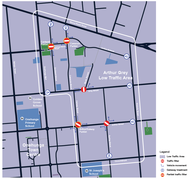
The Arthur Grey Low Traffic Area is a series of modal filters and other traffic interventions in Onehunga, Auckland. These filters are changing the routing network for cars, whilst maintaining access through the existing network for pedestrians and bicycles. Link to detailed intervention designs.

Schematic of the interventions

The interventions are being installed for a trial/pilot period, and are likely to take a different form in their final form (if they are made permanent at all). It is important to map these so that routing is up to date, especially for cars which are significantly affected.

Because the interventions are likely to change in future, it will be useful to keep track of the changesets I have made, in order to quickly access them for review in future. I am using the hashtag #arthurgreylowtrafficarea for relevant changesets, and will maintain the list below.

Changesets

Arthur/Galway Street intersection:

  1. Installed 8/03/2021

Arthur/Spring Street intersection:

  1. Installed 11/03/2021

See full entry

Location: Te Papapa, Onehunga, Maungakiekie-Tāmaki, Auckland, 1061, New Zealand

My February 2021 in OSM

Last few months have been weird. Those of us in more northern latitudes (I’m at 49° North) are just coming out of winter, with much shorter days. The coronavirus lockdowns make most regular social life is cut off. I (& most people I care about) have been lucky enough not to catch corona, but I’m noticing everyone is more snappy than normal.

See full entry

I just added a new query to OSM queries called Mapping Bench Inscriptions.

It illustrates how even a simple OverpassQL query coupled with some conditional MapCSS styling can produce a nice map that can guide a local survey.

In this case its focused on mapping public benches and adding inscriptions and photos to OpenBenches.

There’s a more detail in the query description, but in brief it highlights benches that:

  • don’t have a backrest tag (I see Street Complete also features this as an improvement)
  • have a backrest but no inscription - some benches do and in some locations, particularly along the UK coastline, many do
  • those that have inscriptions but aren’t linked to OpenBenches
  • ..etc

Hopefully both a useful query and an nice illustration of MapCSS at the same time.

Posted by c tito young on 10 March 2021 in English. Last updated on 17 April 2021.

In a geoglyphic area of 50m x 50m two elliptically oiled snakes connected by a third snake, oriented east to west. The snake bodies, of long, medium and short lengths are etched inside a Nazca Trapezoid shape connected by nearby adjacent Nazca Lines. These three snakes are not identical and lay on flat land. The etching suggests one head is located in the center of the spiral, and a second head is located at the spiral’s 4’o’clock position on the outside of the circle and a third head located towards the 3 o’clock position of that spiral. 30m away, connect to this three snake ensemble but yet another snake is another snake in coil, also all in the east west coordinates.

14°40′49″S, 75°6′10″W -14.6803188, -75.1028690 El Ingenio, Province of Nasca, Ica, Peru

Note Must view with Maxar Premium Imagery (Beta).

Location: Ventilla, El Ingenio, Province of Nasca, Ica, Peru
Posted by c tito young on 10 March 2021 in English.

A 150m x 50m twelve point start on relatively flat ground is on the border of Nazca Lines and the nearby hillside. The points radiate from a central location 10m and the rays (about 1m in thickness) and will stretch away from the center as much as 120m.

14°41′27″S, 75°8′41″W -14.6909499, -75.1447104 El Ingenio, Province of Nasca, Ica, Peru

Location: entrada al ingenio, San Miguel de la Pascana, El Ingenio, Province of Nasca, Ica, 11350, Peru
Posted by c tito young on 10 March 2021 in English.

A 50m x 50m geoglyph of a spiral coils from the outside towards the inside. The path is averages about 1m wide and starts from the edge. The Spiral is located on relatively flat ground and is bordered between Nazca Lines and a hillsides.

14°41′23″S, 75°8′17″W -14.6898290, -75.1380800 El Ingenio, Province of Nasca, Ica, Peru

Location: entrada al ingenio, San Miguel de la Pascana, El Ingenio, Province of Nasca, Ica, 11350, Peru

This is a transcript of the conversation that Steve All and I had in private messages, published with his permission.

I believe that this conversation contains some valuable information for those who want to map bicycle routes and mountain bike routes in countries other than USA.

From broadway_lamb 9 March 2021 at 18:33

Hello,

I can see that you are the one who created the GDMBR route relation.

I was wondering whether that route is somehow marked, and if it’s not, what is the policy regarding mapping non-marked mountain bike routes? I can’t find any info on the wiki.

The thing is that I was going to map a similar mountain bike route in Russia, but the local community members told me that only those routes that are somehow marked should be mapped.

Could you please give me some advice?

From stevea 9 March 2021 at 19:06

On 2021-03-09 18:33:14 UTC broadway_lamb wrote:

I can see that you are the one who created the GDMBR route relation.

Thank you for reaching out to me, that is very polite in OSM!

The route known as GDMBR has a long and storied history in OSM. As you can see by its cycle_network tag (US:ACA), it is a route by ACA, the Adventure Cycle Association, a bicycle advocacy organization in the USA which promotes long-distance bicycle touring. ACA has developed a national-scope bicycle network of about two dozen named (not numbered) routes. These route data are private (proprietary / copyrighted by ACA), so their entry into OSM violates our ODbL. However, some cyclists captured GPS data while riding, so for a very few of their routes (3 or so) pieces of these routes (or in the case of GDMBR, the whole of it) are in OSM, and so far it’s “OK” for us to do this, although we shouldn’t make a habit of it, lest we anger ACA.

I was wondering whether that route is somehow marked, and if it’s not, what is the policy regarding mapping non-marked mountain bike routes? I can’t find any info on the wiki.

See full entry