Diary Entries in English

Recent diary entries

I’ve been doing some log analysis on requests to the OSMF-hosted standard tile layer on tile.openstreetmap.org. To do this I downloaded two hours worth of logs and loaded them into PostgreSQL to run some queries. The logs start at ###, and total 11GB compressed starting at 1600 UTC on 2021-02-25.

My main concern has been backend server load, so to analyze that I looked at cache misses - requests where the cache has to request a tile from the OSMF-operated backend servers. Typically the number of tiles requested is going to be five to ten times higher than the number of misses, but it will vary by zoom.

Total cache misses were 3437.4 per second.

The top five referers, as well as some interesting ones are

Referer domain Cache misses per second
None 1254.3
www.openstreetmap.org 418.7
www.openrailwaymap.org 16.0
apps.sentinel-hub.com 15.0
m.turkiye.gov.tr 13.1
localhost, on various ports 30.7
10.* IPs 14.2
Other 1675.4

The top sites vary by time and what parts of the world are awake, but most of the traffic is from the long tail of small sites, OpenStreetMap itself, or an app which should be sending a custom user-agent instead of a website with a referer.

For user-agents, I grouped different versions of some apps together. Like before, I’ve got some of the top ones, then a few interesting ones.

See full entry

Location: 0.000, 0.000
Posted by migurski on 26 February 2021 in English.

OpenStreetMap’s 2021 survey wrapped up just over ten days ago, and the Board has posted summarized results on the Wiki. The geographic survey responses are aggregated to preserve anonymity, in some cases grouping dozens of countries under a single region. The maps below show simple survey results using the Board’s country-to-region mapping to make the responses easier to interpret.

All maps below should be considered “No Rights Reserved,” CC0, or public domain.

Mappers

Let’s start with the mappers. The majority of survey respondents worldwide agreed that the term “mapper” described their involvement with OSM:

“Optional Demographic: Are you a mapper?”

To re-create the map above, and all other maps in this post, source tabular data, region GeoJSON, and a QGIS file are available in a Github gist.

Jennings Anderson posted earlier today with a view of worldwide mapping behavior to put the above results into context. He provides a simple methodology for determining who’s a local mapper for each survey region:

See full entry

Location: Downtown, Downtown Oakland, Oakland, Alameda County, California, 94612, United States
Posted by LucGommans on 25 February 2021 in English. Last updated on 26 February 2021.

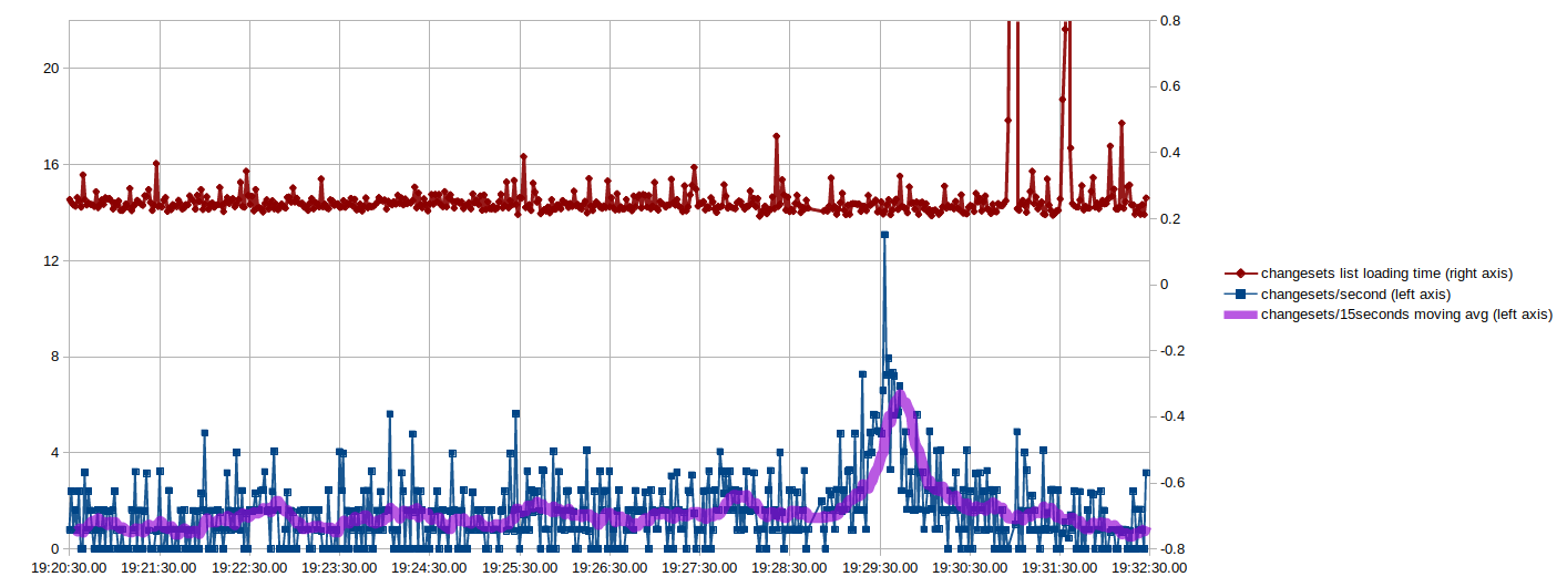
osm.org/changeset/100000000

How many people tried to get that milestone changeset?

How did the server cope with the load?

What was the peak number of changesets per second?

To monitor the changeset count and make my own attempt at getting the hundred millionth changeset, I had a bash oneliner running in a terminal that refreshed the count every 2 seconds and, after changeset 99 999 878, every second. These are the resulting graphs (click to enlarge):

Changesets per second and page loading time plotted per second

The X-axis here is the time, which I think makes the most sense. Another interesting way of looking at it, though, is to plot the changeset number on the X-axis so you can more easily see where the 100 000 000th was and what happened before vs. after:

See full entry

Posted by c tito young on 25 February 2021 in English. Last updated on 11 April 2021.

A manmade 50m x 50m geoglyph resembling a diamond with unequal sub- divided lines intersect and intercross a wedged shape geoglyph forming a diamond. The diamond shape is oriented north to south and placed to be highly visible by anyone approaching the canyon. Other than possible mines located up in the canyons, it is unclear what the diamond shape represents or its purpose.
In measuring the shape in terms of distances and angles, the shape is irregular and does not perfectly reflect distances or angles equally.

14°41′42″S, 75°16′42″W -14.6950575, -75.2784267 Changuillo, Province of Nasca, Ica, Peru

Location: Vicente, Cabildo, Changuillo, Province of Nasca, Ica, Peru

Cartogram

Cartogram showing the number of OSMF survey responses per country

Per Country Editing Activity Since 2020

The OSMF just released the results of the 2021 Community Survey. To normalize the survey results by country, I computed per-country editing counts going back to January 1 2020. This post shares these results, if you’d like to see the analysis notebook and the queries used to do this, you see that here.

Identifying a Mapper’s Home Country

See full entry

Location: Helena, Lewis and Clark County, Montana, United States

This story may be aired as a #Mapping101 Thursdays episode via DP24 General TV

Overview

You might be aware of the mapping overhaul wherein certain features are fixed in almost real-time, especially on the changes that the governmental agencies have executed the plan on bicycle lanes (regardless of separation), city bus routes, MRTs, highways where the changeset 99876939 and its follow-up changesets prove the separation of the bicycle lane from the rest of the highway by any available barriers (i.e. bollards, jersey barrier or block, rope), coupled with the MRT-7 construction updates.

Separating the route relation by direction

Upon adoption to most City Buses, like the one in City Bus E: EDSA Carousel (direction)[1], it is hereby adopted on AH26, select Philippine National Highway routes (including the Metro Manila Radial Road system), and local/regional/national Bicycle Lane routes for easier identification and routing effectiveness, thus preventing the server overload. Likewise, highway routes are needed to be separated to deter ‘duplicated way on relation’ warning on certain highways without median (traffic island or center island) while on mapping validation.

Updates on Buses, Jeepneys

See full entry

Location: Sampaloc 2, Sampaloc, Dasmariñas, Cavite, Calabarzon, Philippines
Posted by c tito young on 25 February 2021 in English. Last updated on 11 April 2021.

A 150m x 150m geoglyph shows a figures head, shoulders, part of a poncho, and two arms/two fists wearing a crown and heavy ear jewelry.
(A thumb portion of the fist appearing on her right hand, seems to have resulted in erosion thus making that part of the hand appearing unfinished.) The positions of both fists on the figure makes the figure look like its boxing, making it unclear of its gesture, but one can assume her hand gestures have a lot to do with that person’s facial gestures. It is important to point out that this geoglyph face and its very dramatic expressions is very hard to “un-see” once noticed its there. It could be suggested that some of the layered terrain features might have been enhanced to reveal a manmade shape. The figures mouth, teeth, nose, head shape, cheekbones, eye and what appears to be an elaborate headdress is undeniably visible, Just south of the geoglyph are multiple line geoglyphs both large and small that seem to frame this figure.

14°41′18″S, 75°15′57″W -14.6882937, -75.2658387 Changuillo, Province of Nasca, Ica, Peru

Location: Cabildo, Changuillo, Province of Nasca, Ica, Peru
Posted by c tito young on 24 February 2021 in English. Last updated on 31 March 2021.

A large 10m x 5m rock and an area of over 50m x 50m have a trail run right through it. It is hard to determine, what this area is for, but it has been suggested for certain ceremonies. TBD

15°17′33″S, 74°32′25″W -15.2925184, -74.5402115 Acarí, Province of Caravelí, Arequipa, Peru

Location: Acarí, Province of Caravelí, Arequipa, Peru

“A challenged world is an alert world. Individually, we’re all responsible for our own thoughts and actions - all day, every day. We can all choose to challenge and call out gender bias and inequality. We can all choose to seek out and celebrate women’s achievements. Collectively, we can all help create an inclusive world.

From challenge comes change, so let’s all choose to challenge.” from the International Women’s Day 2021 website

The theme for International Women’s Day 2021, which is officially celebrated on 8 March, is “Choose to Challenge”. The Community Working Group has chosen to challenge all forms of gender bias and inequality within the OSM ecosystem across the month of March by organizing events featuring community members, activists, and experts.

If you are interested in participating in one of these virtual events or can recommend a person or organization to potentially serve as a speaker, panelist, facilitator, or in another capacity, please comment on this post or contact me directly (info below). We hope to co-create the format and content of the events in collaboration with our speakers.

We welcome all questions and recommendations!!

Contact info:

  1. courtneyclark8@gmail.com

  2. HOT Slack: Message me @courtney_clark or post in the Community WG channel.

Location: Downtown, Columbus, Franklin County, Ohio, 43216, United States

March 10-11 I will present a series of three Big Blue Button video conferences open to the OSM community 8 hours apart to answer questions about results of the OSMF community survey, at noon UTC and 2000 UTC March 10, and 0400 March 11 UTC (these correspond to 0700, 1500, and 2300 EST). I will present some summaries of the data in graphic form, then take questions. I will use my Big Blue Button home room at https://osmvideo.cloud68.co/user/all-3t3-ekg

I also plan to open an instance of Microsoft Translator and to speak into it in English, and will share the access code for the instance at the start of the presentation, so that anybody with Microsoft Translator’s app (on desktop, notebook, tablet, or smart phone) can follow my oral narrative in the language of their choosing. I will also use the Power Point 365 facility for rendering speech to text so that anyone who can read English can read subtitles as I speak. Anyone planning to view the video conference should download the Microsoft Translator app in advance and become familiar with it first.

Posted by ottwiz on 23 February 2021 in English. Last updated on 2 March 2022.

I think i’ll be short about how I map addresses in Rákospalota. I once got some addresses from a document to OSM but didn’t notice it that it’s just for reference, so lot of addresses were inaccurate in it.

Because I’m now a university student (actually a freshman), studying in my 2nd semester, I have to register for P.E. classes (in the 2nd and 3rd semester as suggested). That’s what I did in January, when registering for subjects started. The problem is that university is closed because of COVID-19, so nobody can enter the area of the university without written permission from the rector.

Every student who now are completing P.E., have to track 100 kms (62 miles) of walking/running or rowing (or 200 km by bicycle, 20 km/trip and 40 km max a week) in the semester totally with Strava application on smartphone, minimum 5 km (3.1 miles) per trip, and 15 km (9.3 miles) can be signed a week.

So because of that, I started walking in my area, but I was like “Hey! I don’t wanna get bored, I want to survey my area, because OSM is still lacking lot of addresses and some are inaccurate, let’s fix this!”

In Budapest every district has their street signs at each street corner to show where you are and what are the interpolations between the two ends of the street segment. I started to write down the interpolations into my phone, and then when I arrived home, I put the data on OSM.

But also, we Hungarians have a different address reference than the one I was using, and it seems a bit more accurate, even if it’s not a map, but it has some false addresses(I gotta know this because I know where a street starts and where it ends), so at least I can report to the maintainer that there is an issue (https://osm-gimmisn.vmiklos.hu/)

I usually use this website to check out what “/A” “/B” etc. addresses to look for when I’m surveying on the spot, because my neighborhood is full of those divided plots, like Sín utca for example.

See full entry

Location: Rákospalota Öregfalu, Rákospalota, 15th district, Budapest, Central Hungary, Hungary
Posted by c tito young on 22 February 2021 in English. Last updated on 15 April 2021.

A 100m x 100m geoglyph resembles a figure wearing a cap and poncho, and looking over its shoulder. The figure with an open mouth, one ear visible, and wearing large cap with a v-neck poncho has one arm tucked and other extended. Oriented north to south its extended arm points east while its head points west. The figure’s cap appears to be textured elaborately.

Directly south of this geoglyph (300m) based only on proximity, are several complex geoglyph lines that seem to bring attention and frame this geoglyph.

14°40′4″S, 75°14′2″W -14.6678238, -75.2338494 Changuillo, Province of Nasca, Ica, Peru

Location: Chiquerillo, San Juan, Changuillo, Province of Nasca, Ica, Peru
Posted by mapmyplanet on 22 February 2021 in English. Last updated on 13 April 2021.

Although I am a Pennsylvania resident, I spend a good deal of time in Delaware, exploring natural areas such as parks, State Forests, and Preserves. My hobby is to record the GPX traces for my hikes in order to add hiking paths to OSM. I use OSMAnd for tracking and edit OSM using iD and JOSM.

In the course of recording these map features, I’ve noticed some of Delaware’s public lands in OSM do not conform to the standards expressed in the United States/Public Lands wiki.

I have started a discussion on the Delaware wiki page in an effort to expand the Delaware wiki to specify tagging standards for Delaware’s public lands. My starting point is to work on the State Forests.

I’ve also noted that the outlines some (many?) of the State Forests don’t match the data that can be pulled from PADUS. I am working to resolve this discrepancy.

After the State Forests are corrected, I will move on to address other public lands in Delaware. I invite collaborators.

Location: Downingtown, Chester County, Pennsylvania, 19335, United States

The OSM Foundation started publication of the results of the The 2021 OSMF Community Survey where we can download a spreadsheet with the Comments received in the survey.

In the second section, you will find extracts of individual comments that I interpret as being related to the Question F1 about Diversity and Inclusion Special Committee and complaints about Systematic Offensive behavior in the OSM Community.

But first, if we look at all comments listed, my perception from the comments is that many participants to the survey are looking at the various actors and politics that are played and want to insist on various challenges facing OSM and often concern about the dynamic with the various actors and the various agendas. Note that this is anonymous data, and that comments below are my interpretation reading these.

The participants comment on the various actors and their actions, plus the impact on OSM. We can observe how they are seing political actions and the various actors and they perceive actions including from volunteers, Data Working Group (DWG), Influencers on Tagging discussion, paid and Corporate contributors, local communities and the usage of AI tools, Tagging of Disputed territories, Mechanical edits and Imports and even Non-OSM-Attribution by dominant Corporate actors. The OSM ecosystem creates great possibilities of collaboration and innovation for various products and answers to various needs.But with such dynamics, there are actors that are more in position of power like the Corporate actors, Software developpers or even small groups that control tagging schemes. Contributors like «tagkeepers» using mechanical edit tools have important capacity of action. Democratic play inside OSM means informations, discussions, and way to progress to concensus. But like any other political play, it is not easy to simply establish the facts, and accept to find solution, share powers with others, or accept that others have power they dont want to share.

See full entry

New

Posted by ucnwangwu on 22 February 2021 in English.

Hello! I am new here and happy to become one of you. I was introduced to OSM by Victor Sunday who happened to be my map making mentor and we have done some great mapping work together. I am a member of Unique Mappers Network Nigeria.

uniquemappersteam

#uniquemappersnetwork #uniquemappersteam202

Posted by Stereo on 21 February 2021 in English. Last updated on 22 February 2021.

The raw results of the 2021 OSMF Community Survey have now been posted. One of the questions asked people to rank seven choices for what the board should work on:

In 2021, what do you think should be the priority order of tasks the Board of Directors has set for itself?  Please rank the tasks in order of relative importance to the OSM project.

A vote counting method that’s relatively easy to implement in a spreadsheet on a Sunday evening is the [Borda count]. I’ve done a slightly modified one - an option at first rank gets 7 points, second rank 6 points, etc., until 7th rank gets one point.

The results actually match the results if you rank by first preference. Fund-raising gets high ranks in subsequent preferences, but because it’s not high in the first preference, it ends up in the middle of the final count.

Choice Borda score
Stability of the core infrastructure (hardware, software, human capital) 16591
Takeover protection 11179
Outreach to Local Chapters and Communities 9799
Fund-raising 9529
Attribution guidelines 8307
Recruitment for Working Groups 8299
Brexit 4330

Does anyone want to try a Condorcet ranking?

I mostly agree with that list of priorities.

I hope that I find enough free time to work on hiring our Senior Site Reliability Engineer very soon.

Board members don’t agree on how much a threat takeover is, and how to protect against it - this is definitely something where the members need to make their voices heard. Message me, email the board, post in the comments below.

See full entry

Location: Hollerich, Luxembourg, Canton Luxembourg, Luxembourg
Posted by c tito young on 21 February 2021 in English. Last updated on 11 April 2021.

A geoglyph of a 100m x 100m is of a salmon seemingly leaping out of the water. Drawn as a “side view” the geoglph reveals its long curved body, wide open mouth, eye and tail. The drawing is oriented north to south. The head of the fish points itself north and the tail points to the south.

15°17′13″S, 74°30′37″W -15.2868127, -74.5103940 Acarí, Province of Caravelí, Arequipa, Peru

Location: Acarí, Province of Caravelí, Arequipa, Peru