Diary Entries in English

Recent diary entries

Posted by c tito young on 12 February 2021 in English. Last updated on 10 March 2021.

Twenty two geoglyph head shapes in two groups are situated sided by side and oriented north to south. The heads have sizes ranges of 10m wide x 150m long. Included the group of figures, there is also an etching of a cat laying sideways oriented east to west. The laying cat is approximately 15m x 50m and can be located as the 3rd figure from the right of the group of geoglyphs. All the figures lay on a low slope that rises 20m height in 150m of length. Also suggested in the geoglyph etchings is a large leaf (face?) and another etching of a tree (something else?). To the southwest of the valley there is at least five other valleys, that possibly other additional visible shapes might be recognized there.

In the immediate area, within 200m of the string of figures are multiple triangular shaped geoglyphs of either shapes or lines.

There will be an additional follow up in this area in the near future.

Location: Santa Elena, Changuillo, Province of Nasca, Ica, Peru
Posted by Casey_boy on 11 February 2021 in English.

Intro

One of my current hobbies is mapping Public Rights of Way (PRoW) routes in Lancashire.

This hobby came about after walking various routes in the beautiful Lancashire countryside, with my canine companion, only to find that they weren’t all showing up in OSM.

PRoWs, such as public footpaths and public bridleways, are core components of our right to enjoy the countryside and so I feel that it’s incredibly important to get them mapped in OSM. After all, if you don’t know a PRoW is nearby then you’re unlikely to ever make use of it.

Every local authority is required to keep a record of the PRoWs in their area - known as the definitive map and definitive statement. Most councils (though not all) have made this data set available for re-use (see list here).

The best way to map a PRoW is, of course, to do a ground survey. But, given the sheer number of routes in Lancashire (and most other authority areas), this has meant that the majority of routes have gone unmapped.

So I’ve taken to armchair mapping when visiting the PRoW just isn’t practical for me.

Sources

I use the Lancashire County Council’s PRoW GIS data, under the OGL v3 licence, through a MapBox layer to trace the PRoW route in OSM. I then also cross-check the route with mathmos.net to ensure I get the designation (e.g. public footpath, public bridleway) and prow_ref tags correct.

The mathmos.net site is also great as it allows me to check on the progress of the mapped routes in Lancashire - so I can see where routes are missing from the map and add them as necessary.

Of course, I can’t add tags such as surface or always know about obstructions on the route (e.g. stiles). And it’s important to note that the data provided isn’t always entirely accurate or up-to-date.

My editing of existing routes

See full entry

What I WANT to do is take Mapillary photos with my phone’s wide angle lens. If I could find a way to easily do this, Mapillary would be a productive way to have fun and adventure! Maybe even a good excuse to buy a GoPro.

However, I have an Android phone and Android tablet. I don’t have a traditional desktop computer. I’ve found that Mapillary’s support for users without an Apple nor Windows device has been…completely minimal. And it’s frustrating me to the point of burnout.

In terms of editing OSM, images taken with the standard lens on the Mapillary Android app can be nearly useless sometimes. I’ve had plenty of instances where I’ve been unable to verify street names, other signage, etc. Gathering house addresses, names of businesses, and other features not DIRECTLY near the road is often impossible. By the time something is close enough to see well, it’s out of frame or blocked by the vehicle ahead of me.

Plus, aesthetically, having imagery that only looks straight down roads is super-unappealing. It squanders Mapillary’s ability to stitch nearby photos together.

The last few days, I’ve instead been taking pictures with my wide angle lens on OpenCamera. The results have been REALLY useful for OSM editing, and creating pleasing Mapillary image collections.

The problem is, the only option for uploading is the Web uploader – I can’t use the Desktop uploader.

So EVERY sequence I submit, I need to personally, MANUALLY hunt down duplicate images (from standing still at intersections) AND normalize the sequence. And make sure no sequence is too big. AND the web uploader behaves frustratingly when you’re using a touch screen instead of the mouse it expects you to use.

Anyone got a straightforward fix for this?

Posted by ebt12 on 10 February 2021 in English.

My latest project has been mapping the features in the Pittsburgh Renaissance Festival and the Great Lakes Medieval Faire (GLMF). Examples are the jousting areas, the live chess match board at GLMF, and vendors. I have been using the maps of the faires available online and my own experience from attending these faires for many years. Not everything can be mapped because some of the features are obscured by trees, and the pixilation of the images when zooming in.

Location: Mendon, South Huntingdon Township, Westmoreland County, Pennsylvania, 15695, United States
Posted by cwUL23 on 10 February 2021 in English.

The Mapping Project in Celbridge in County Kildare commenced about three weeks ago. It has probably been one of the most interesting tasks of my internship and an excellent learning opportunity for me.

My mentor, DeBigC presented the project to and explained that a Local County Councillor was keen to have Celbridge mapped to an exceptional extent. The locals seemed enthusiastic and were aware that a high quality mapped Celbridge would bring many benefits to the town.

My first duty was to go out and find mappers who had a knowledge of Celbridge or locals who would be more familiar with the town. I reached out to those I could find, approaching them with a friendly message explaining we needed urgent help to improve the town. A total of four people showed interest and were happy to help. DeBigC and Vanessa, the CC who initiated the project attracted more locals and, in the end, we had 13 members involved.

As soon as we gathered the group, the next step was to plan the stages of the project. After a few discussions with my mentors, I drafted a brief plan to aid one of the OSM board members with the wiki page for the project.

Subsequently to the plan being published we could finally be mapping Celbridge! My mentor created a task for the town which split Celbridge into squares, making it easier for both beginner and advanced mappers to have a go at it! I used OSM analytics to create a visualization of what buildings in Celbridge were tagged ‘buildings = yes’. That current images shows the remaining buildings and will hopefully be tagged accurately in the second task!

So far, the progress of the project has been unbelievable! Without the enthusiastic locals, the board members of OSM putting in great efforts or Vanessa’s eagerness and motivation, the project would not have advanced so far in such little time. There is still a little bit to go, adding the finishing touches to Celbridge to ensure it is of high quality once it is completed.

See full entry

Posted by c tito young on 10 February 2021 in English. Last updated on 10 March 2021.

Multiple geoglyphs sizes ranging from 50m to over 300m on a slight slope of of land express on a ridge trail animals, shapes and supernatural. If there is a story in regards to these etches on this mountain side, there seems to be a relationship between natural and supernatural. There also seems to be a cycle of themes, and recurring dreams or other explanation to gods.

Several of these geoglyphs define fire, ruling, war, underworld, spirituality and even other cosmic or astronomical situations, including the supernatural and the life beyond.

Location: La Primavera, Vista Alegre, Province of Nasca, Ica, 11401, Peru

crosspost on medium

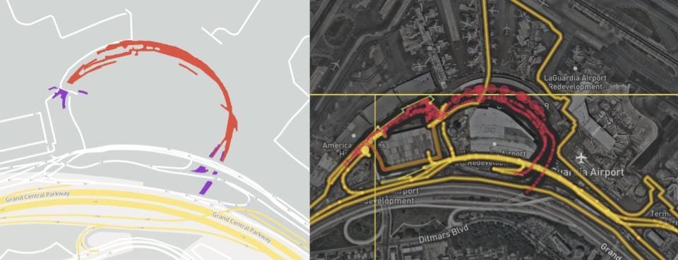
Mark Huberty & Clare Corthell, Lyft Mapping Roads to the new terminal at LaGuardia Airport opened in July 2020, evidenced by aggregate Lyft traffic (left). OpenStreetMap data had been updated (right) shortly after opening, faster than many other maps.

Lyft Mapping study shows crucial OpenStreetMap road attributes are fresh and high quality in 30 North American cities, as compared to groundtruth.

Lyft moves people — from home to work, work to play, play to rest, through cities and beyond. Maps play a critical role, helping Lyft figure out where drivers and riders are, how best to connect them, and estimate how long it will take to get to the destination.

See full entry

Posted by c tito young on 9 February 2021 in English. Last updated on 10 March 2021.

Geoglyph of an Incan Warrior 75m Wide x 150m long, is an etching of a man with a helmet, sword and shield from the waist up. There are no indications of his legs and feet. Etched as a geoglyph on a slight slope oriented north to south and its figure is facing forward. This Incan Warrior appears that it is actively giving a speech or a war cry while raising his fist as some sort of expression. He wears body protection, with a facemask that has pointed horns and a chin guard with eye/face protection. He seems to be part of an organized warrior with traits and customs related to protection and attack. He is etched on rock, holding a sword (machete), that is almost 50m long. It is unclear as to why he had been drawn on the rock. A long forgotten hero?

To his immediate right, is what looks like a geoglyph of a ghost, possibly suggesting the death of an opponent. On his immediate left is another ghost like feature. This second ghost had been etched upside down and over some previous etchings that will requiring better resolution to better understand this geoglyph.

Location: La Primavera, Vista Alegre, Province of Nasca, Ica, 11401, Peru
Posted by c tito young on 9 February 2021 in English. Last updated on 10 March 2021.

Spanish: Geoglifo de Dieu Incas con Serpiente

The geoglyph of the Dieu Incas with Serpent is over 100m wide x 200m long. Oriented north to south, it sits on a moderate slope surrounded by other geoglyphs telling a themed story. Its profiled head, body and snake headwear faces east and the figure of this subject becomes less and less distinguishable below its waist. The depiction is a man, carrying a backpack, with a large python snake coiled on its headdress. It looks down staring at its hand. Both the snake and him are directing their view to the same place, but its difficult to determine exactly what. He has long hair, wears a thick coat and one can see his backpack is tightly bundled with what appears as ropes. In its backpack it carries the head of a cadaver, and helmet and some other stowed items.

Location: La Primavera, Vista Alegre, Province of Nasca, Ica, 11401, Peru

I want to share a community investment initiative HOT Is piloting in collaboration with OMDTZ (OpenMap Development Tanzania).

Over the next five years, HOT aims to support a movement of individuals and communities who create and use OpenStreetMap data to improve local lives and livelihoods in places vulnerable to crisis or experiencing multidimensional poverty. The strategy for using the Audacious project funds to achieve this centres around moving decision-making, resource allocation, support and engagement closer to these places. Partly, this is through the launch of four regional mapping hubs, but we also want to try and innovate in other ways.

HOT’s microgrants programme has proved successful over the years but we know that our reach in many places is limited and that, despite a diverse community panel for selecting winners, we cannot have a deep understanding of the context (and therefore the challenges, opportunities and constraints) in every one of 94 countries.

For this reason, we are piloting a devolved community investment programme, where we can pass on the budget for multiple grants to a trusted partner (in this case, OMDTZ) to design and implement a programme at a national level. With a few caveats (around principles, objectives, diligence and reporting requirements), we want OMDTZ to be free in designing a programme of community support and investment that works for Tanzanian contributors, communities and organisations.

We hope that by doing this the funds will be more accessible and have greater local reach, that the funded work will have greater local relevance and impact and that we (HOT) and others can learn from OMDTZ’s successes and failures and improve our own programme.

We also hope that, if the pilot is successful, we are able to replicate or adapt a similar strategy in other countries with strong OSM community organisations. In fact, if you think this is something that could work where you are, we’d love to hear from you.

See full entry

Posted by Rob Lanphier on 9 February 2021 in English. Last updated on 14 February 2021.

I think I’m getting the hang of OSM editing again. Back when I lived in West Seattle, I did a lot of OSM editing of the really-poorly aligned maps of my neighborhood. Once I moved to West Portal, I found OSM didn’t seem to need as much help in my neighborhood. I’m in a different neighborhood of San Francisco now, which the maps aren’t as good, but I’m hoping to improve them.

I’ve created a grouping (a “road route”) for Guadalupe Canyon Parkway: https://www.openstreetmap.org/relation/12291160. My hope is that I’ll learn how to do this correctly by editing a portion in an area that many editors know well, so that I can do things correctly when I’m in an area that most other folks don’t know well.

UPDATE: I created an item in Wikidata for this road (https://www.wikidata.org/wiki/Q105488967) and linked relation/12291160 to it.

Location: San Mateo County, California, United States
Posted by c tito young on 8 February 2021 in English. Last updated on 11 March 2021.

A side view of an octopus geoglyph 25m long x 20m wide shows an etching of eight arms and two eyes, facing east on a moderate sloped land. Its arms loosely coil with one of its eight arms appearing to be holding on to some sort of object. It is unclear what is the purpose or what was intended by drawing of this octopus

There is another geoglyph to the east of the octopus, It is unclear what if there is any relationship this octopus geoglyph has to that object. .

Location: La Primavera, Vista Alegre, Province of Nasca, Ica, 11401, Peru

Traduction fr : Un système d’exploitation Ubuntu 20.04 virtualisé / léger sur Windows 10

We dont all have access to a Linux OS, but note for Windows 10 users, that you can easily install a virtualized Ubuntu 20.04 OS. It will work simultaneously with Windows and will require little ressources. See this tutorial on how to install WSL2 and Ubuntu 20.04 https://alessio.franceschelli.me/posts/windows/wsl2-upgrade/

As said in the tutorial :

« WSL2 is the second iteration of the Windows Subsystem for Linux which finally allows running linux virtualized inside Windows. This new version brings real  virtualization using a real linux kernel, but, compared to a traditional virtual machine, it runs on a lightweight hypervisor getting close to bare-metal performance.»

You can even communicate with you Windows PostgreSQL server, replacing localhost by samenet

ie. psql -h samenet -p 5432

If you have problems to communicate through internet, look at your firewall to assure it does not block ougoing links from your linux OS.

Good solution to tests / Develop. While writing test scripts for changesetMD Replication scripts, I was able to use this solution to test easily on my laptop.

The humanitarian OpenStreetMap Community Working Group has taken the decision to revisit our scope and purpose.

We want to better serve…

  • OSM communities in places vulnerable to humanitarian crisis or experiencing multidimensional poverty
  • Communities or orgs that use (or want to use) OSM for social impact
  • People that want to show solidarity with these communities through collaboration and support.

…and be less focused on the Humanitarian OpenStreetMap Team (HOT) specifically.

Draft community definitions

In order to work out how to evolve, we would like to invite interested people to join us in one hour workshops to try and understand what scope, principles and objectives will serve this new purpose. We would love to have a diversity of people and perspectives inform this work.

The insights from these workshops will be used to inform a draft of the working group’s new terms of reference, which will be published in advance for consultation.

See full entry

Posted by c tito young on 8 February 2021 in English. Last updated on 11 March 2021.

The 60m wide x 70m long front facing geoglyph of the Sun God is oriented close to northeast to southwest. This representation shows a stern jawline and stern mouth, two piercing eyes, and prominent nose lays on a moderate slope. The artwork has shoulder length hair and feather headdress like crown. The face depicts high cheekbones. There is no references to a torso arms or legs. The head faces straight forward, with little understanding on how it related to other nearby geoglyphs.

To the left of this geoglyph (5m) is a 25m x 25m geoglyph, It seems to be oriented in the same direction as the geoglyph of Sun God, but how its related is not clear.

Location: Vista Alegre, Province of Nasca, Ica, Peru
Posted by c tito young on 8 February 2021 in English. Last updated on 15 April 2021.

The Geoglyph of the Groove Bill, 210m long x 100m wide is of a flying bird heading pointing in the westerly direction. The etching shows a side view of a body, and extended wing is propped over its body, with a long tail fluttering behind. Situated on a land surface of moderate slope along with many other geoglyphs might suggest this flying bird depiction might be part of an story. Other geoglyphs near this animal image, might or might not be necessarily related.

Location: Vista Alegre, Province of Nasca, Ica, Peru
Posted by SomeoneElse on 7 February 2021 in English. Last updated on 14 June 2022.

The OpenStreetMap Community Index is designed to show people what community groups there are within OpenStreetMap, in any part of the world. If I look near me I see a local pub meeting (sadly on hold during the pandemic), some country-level resources, and then international resources.

On a couple of occasions I’ve seen things that are missing or need updating, and this diary entry is designed to complement the existing documentation to describe what needs to be done to fix that.

Creating a local copy

In my case I already have a fork of https://github.com/osmlab/osm-community-index at https://github.com/SomeoneElseOSM/osm-community-index. There’s a “fork” button in the top right of Github’s UI that allows you to do this.

Next, I’ll create a local branch to work on. The default branch at https://github.com/SomeoneElseOSM/osm-community-index is “main” and the UI will say “This branch is even with osmlab:main.” because (in your case) you’ve only just created it. In github’s branch selector just type the name of the new branch to create. In this case I created “add_forum_at_world_level”, because I noticed that there wasn’t a link to the OSM Forum at the international level, although there are many links to country-level forums from the community index.

Next, “git clone” your repository wherever it is you want to work. I’m working on a completely new virtual machine to do this, so I have to take a slight detour first - see “setting up ssh access to github” below. Once that’s done:

mkdir ~/src
cd ~/src
git clone git@github.com:SomeoneElseOSM/osm-community-index.git
git checkout add_forum_at_world_level

Note that I’ve used a version of “git clone” that is designed to work with ssh. Github is (rightly) moving away from password-based verification and will send you a warning email if you try and use a password during the transfer period.

See full entry

Location: 21.871, 33.737
Posted by c tito young on 7 February 2021 in English. Last updated on 11 March 2021.

The geoglyph of the emu 75m wide by 150m long and oriented north to south on a moderate sloped terrain depicts an emu feeding from the ground. The bird is facing the viewer but also turned towards the east. There are suggestions of heavy feathering for the animal, but the current sat image is unclear if suggestions of repeated coloration changes that might be representative of long plumes of feathers were intentional for the animal. Look along of the animal’s head, neck and back. The artist rendition of the animal gives it ergonomic stature and gives the feeling this animal is a survivor. It is unknown at this time whether or not this image is related to other nearby geoglyphs. The three toed, long legs, body, long neck head and beak are etched wonderfully. It is unclear if the animal is related to the other nearby geoglyphs and exactly if there is additional stories to be told regarding this artwork.

Location: Vista Alegre, Province of Nasca, Ica, Peru