Diary Entries in English

Recent diary entries

I first contributed to OpenStreetMap in 2014 in a small town in rural Italy where I briefly lived/worked after finding it wasn’t mapped on any platform. After seeing the small town appear on the map I was hooked. Since 2017, I have led a monthly OpenStreetMap meetup, MapABQ, in Albuquerque, New Mexico focused on contributing to OpenStreetMap in New Mexico, an often overlooked area in the United States. Since the group’s inception we’ve engaged with existing mappers around New Mexico and recruited a number of new mappers, while greatly increasing data coverage in New Mexico on OpenStreetMap. Professionally I am a software engineer focusing on geospatial data. I’ve developed tools around OpenStreetMap with Humanitarian OpenStreetMap Team (HOT) and use OpenStreetMap data in my current role with SharedStreets.

I am running for the OpenStreetMap US board of directors for 2021-2022 and I have the following priorities:

Support of local communities

I believe OpenStreetMap thrives best in local communities and supporting the growth and sustainability of local groups is mutually beneficial to OpenStreetMap US. Scholarships to State of the Map US and microgrants for specific projects are great ways to increase participation and engagement from often overlooked regions in the US.

Sustainability of the organization

To ensure the success of the executive director role additional paid positions within OpenStreetMap US may assist in the administration and operations of the organization. Paid roles require consistent funding and long term planning to be fully effective. I seek to promote diverse funding, increase membership, and further cultivate existing donors to ensure financial sustainability.

Increased engagement

See full entry

Location: Barelas, Albuquerque, Bernalillo County, New Mexico, 87190, United States
Posted by apm-wa on 24 January 2021 in English.

The OSM Foundation Board of Directors needs your feedback on actions it took in 2020 plus your sentiments regarding controversial questions, and asks for some demographic data (optional) so we can understand better both the survey data and the structure of the community. Coincidentally, the survey is divided into “Feedback”, “Community Sentiment”, and “Demographic Data (optional)”.

After seven days, the OSMF 2021 Survey of the OSMverse has received 1,918 responses in total, of which 1,424 are “full” responses (that is, they include the optional demographic data).

A sum of 1,918 total responses means the survey features a 2.24% confidence interval at the 95% confidence level, and a 2.95% confidence interval at the 99% confidence level. The survey features a confidence interval under 3%! This is good validation of the sample, though I suspect it still suffers from a European and North American bias. Male respondents also dominate the sample quite heavily. Therefore: please spread the word, especially to colleagues in Africa, Asia, and Latin America, and to women and non-binary mappers! And data users! And software developers! And systems folks! Everyone in the OSM community!

We are shooting for a 2% confidence interval at the 95% confidence level, for which we need a minimum sample of 2,401 “full” respondents, and preferably they will be distributed geographically. Since about a quarter of respondents so far have declined to provide demographic data, this implies we need to hit 3,201 “total” responses or thereabouts.

See full entry

Posted by DW2515 on 24 January 2021 in English.

Who am I?

Hello, My name is Daniela Waltersdorfer, although in the OSM Community I’m known by some of you as Dani. I had the pleasure of serving as a OSMUS Board member for this past, and very difficult, year. I work in the Transportation Industry and run, with my awesome two co-hosts, Maptime Boston. In 2019 I joined in on the OSM US Code of Conduct Committee, developed to lead efforts to foster a diverse and inclusive OSM US community and this past 2020 we published the first ever OSMU US Code of Conduct (you can find more information here: osm.wiki/Foundation/Local_Chapters/United_States/Code_of_Conduct_Committee/OSM_US_Code_of_Conduct#OpenStreetMap_US_Code_of_Conduct )

Why am I running?

If you’d like to read my Manifesto for 2020, you can find it here: osm.org/user/DW2515/diary/392037 As you probably read, I am passionate about making this awesome community more welcoming, regardless of your technical skills. 2020 proved difficult to make these connections in-person- we didn’t have our beloved and biggest event of the year, State of the Map. However, although discouraging at times, this did not stop the Board in brainstorming with Maggie ways to increase grow our community. For more transparency, something I really value, I’ll share about my big expectation. I had hopes of creating a bigger connection between the transportation world and OSM US, especially with the private sector. You see, I work for a transportation consultant firm, meaning I work closely with cities, MPOs, States, and sometimes federal agencies in making transportation planning and engineering decisions. For various projects, OSM data has proven to be quite exquisite and impactful. So why not give back to this awesome project? Unfortunately, the pandemic slowed down some of my goals of creating a more connected community, especially when it comes to sponsorships and funding, for it has impacted many individuals and companies negatively in the economic realm.

See full entry

Posted by c tito young on 23 January 2021 in English. Last updated on 11 March 2021.

I may have proved a point. Elaborate geoglyphs equal elaborate ground etching and the two go side by side. To the southwest of the valley of the elongated heads is an array of geometry of accuracy that cannot be of chance. Lines tangent and alignments set up a series of geometry. More and more these geometries were created so that a culture can do anything and everything it can to appease gods for crop growing or better weather. Not always are these glyphs of recent times but rather it seems to be built upon each other through generations. Could it be a marking of success, or failure like the stock market? Could these represent navigation points? Could these lines be part of a machine? Could these lines point to shapes that tell a story? In some areas, shapes are surrounded by lines, some finished while others unfinished. There is some of the lines that obviously connect, and others that are close, near misses or that the terrain fails to give much clues as to what used to be there, and ALL seem intentional. .

2nd Entry:
How exciting to find additional geoglyphs to the east of the valley of the elongated heads. Finding it substantiates the overall importance that these glyph geometries are part of symbols that start to unlock the Nazca geometric efforts. I am taken by yet the fresh and very different types of lines and how the geometric shapes interlock. Surprisingly, I didn’t see them before, but as I am identifying each one by one, some of the line escape the other lines and shapes giving way to a brand new area. Are they doing this as a desperate way to save their crops or are they after something else. Why is the secret so difficult to understand? The more dive into these weird and obscure lines, knowing they have been created over a period of around 2000 years at least, the more questions they have. What is their secret? Why are they really doing this? Why is the geometry so precise?

Location: Santa Elena, Changuillo, Province of Nasca, Ica, Peru

Une connaissance cartographe m’a récemment transmis ce lien, d’un article daté de 2013 sur la cartographie participative et l’évolution récente de la cartographie en tant que discipline.

Il y a un paragraphe sur OpenStreetMap qui vaut la lecture. Et qui apporte sans doute un regard extérieur sur notre communauté (ce qui est rare). Voilà notamment un extrait:

“(…) le terme d’amateur peut difficilement être accolé au « mappeurs » d’OSM ! L’entreprise reste dominée par les développeurs informaticiens ou les geeks, passionnés du Web et des nouvelles technologies”

Même si l’accessibilité à OpenStreetMap s’est améliorée depuis 2013, je pense que ce jugement est toujours vrai. Bien sûr il y a probablement une majorité de contributeurs qui n’ont pas le profil “développeur” mais j’ai l’impression que plus les contributeurs sont impliqués dans OSM, plus ils correspondent à ce profil.

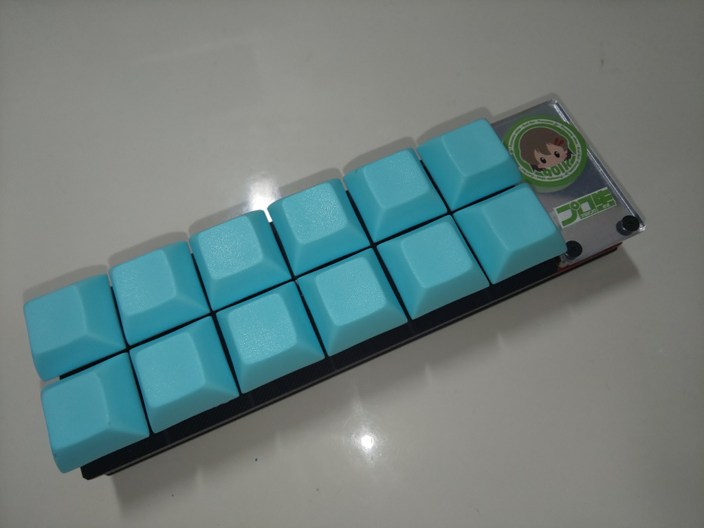
Mapbox has a document for using a gaming mouse to increase mapping. I build a custom keyboard and assigned JOSM’s shortcut keys, because unfortunately, I couldn’t find easy to use multi-featured trackball.

I built a keyboard is custom keyboard kit called “Dozen0” with 12 keys.

dozen0

The shortcuts assigned to the 12 keys are follow image.

See full entry

Posted by apm-wa on 22 January 2021 in English.

At the moment, after 5-1/2 days, we have 1496 responses, of which 1116 are “full”, meaning they include demographic data that will allow us to do some cross-sectional analysis (almost 29% of respondents decline to provide demographic data). But keep spreading the word. We have 16 languages available: (English, Chinese (Traditional; Taiwan), French, German, Indonesian, Italian, Japanese, Korean, Persian, Polish, Portuguese (Brazilian), Russian, Spanish, Turkish, Ukrainian, Vietnamese). If you know of a group that needs another language and can link me with someone to translate the questionnaire, please do so! I have become adept at copying and pasting languages I don’t understand into Lime Survey.

We needed 1067 respondents to achieve a 3% error term at the 95% confidence level, but now I’d like for us to push for a 2% error term. As you all know, the larger the sample, the more accurate the estimates, and the wider we cast our net, the less the selection bias. For that we need 4160 respondents. We have three weeks left in the survey so it is possible if we continue to spread the word. Please help! The URL is https://osmf.limequery.org/281662 Please spread the word in whatever other languages you can, please encourage OSMers to participate, please use all available communication channels to reach as many corners of the OSMverse as you can!

Posted by c tito young on 22 January 2021 in English. Last updated on 23 January 2021.

I have been noticing the Nazca Lines and triangle shapes are generally “large, clear and easily” visible. I have been raising the questions on the lines that are small, old looking and barely visible. I think its for more important to record these before they get grown over or washed away, so I have been making a conscience effort in recoding them. One of the lines I placed down crossed the entire valley, but it wasn’t as clean looking as earlier lines. I think if its clear to you that these lines are visible, but old, worn or even tiny, record them.

I am still looking for patterns on these shapes. Its important to recognize the ends of the line point, aim or circle around.

The most important thing one can do on these Nazca lines is get them recorded.

The NGO HOT US Inc organizes an election to replace one of its directors for a 6 months term.

Details of the election read on a wiki page

Below reads my electoral platform.

Summary

My OpenStreetMap journey is two fold. First, I co-founded the Humanitarian OpenStreetMap Team (HOT) concept in 2008, I co-founded of HOT US inc in 2010, I served the org as a Board member (2010-2014) and as its de facto Operations Manager for Haiti and Sub-Saharan Africa (2010-2013). Second, I co-founded the French associations Projet Espace OSM Francophone (ProjetEOF) and Les Libres Géographes (LLG) which supported technically and organizationally at grassroot level the growth of autonomous OSM collectives in Haiti and French-speaking Africa from 2014 to date. I developed a span of skills and experiences fit to serve 6 months at the HOT US Inc Board and help the organization in its willingness to reflect, change, localize, decentralize and implement its activities in a way more respectful of the OSM way and especially OSMF policies, jurisprudence and practices. Through the inner human, technical and organizational knowledge I had built over time in these Francophone countries whose language is, by the way, not currently represented at the Board, I think I can help the organization through its willingness to change described by Tyler by serving at its Board for the next 6 months.

Detailed version

Given the tight timeline for this election, this diary nots is work in progress and likely to be expanded at a later stage.

See full entry

Posted by TreeTracks on 21 January 2021 in English. Last updated on 30 January 2021.

UPDATE: Version 2 of the following draft was added to the Australian Tagging Guidelines on 30 Jan 2021. A short note and link to the Australian page was also added to the the international wiki highway=rest area.

The following notes provide a summary of comments on tagging roadside rest areas in Australia, based on a discussion on the OSM Australian mailing list in January 2021. Pending feedback on this draft, these notes will be incorporated into the Australian Tagging Guidelines and/or the international wiki highway=rest area.

Suggest adding a new section in the Australian Tagging Guidelines after the current section: ‘‘3.1.7 Tunnels and bridges and layers”, as follows.

Version 2: after comments received before 26 January

3.1.8 Roadside rest areas

A wide variety of rest areas are common on regional roads. Some parks on major roads in regional towns are signposted as rest areas. These parks are often managed by local councils rather than road boards and may be well used by local residents. These are best tagged using leisure=park (not highway=rest_area), name = “XXX Rest Area”. Features such as toilets and playgrounds can be added as separate features.

Roadside rest areas may be mapped using either a single node or a closed way (or area). Some small roadside stops directly adjacent to the roadway have been mapped using amenity=parking (with additional tags) rather than highway=rest_area. However, most roadside rest areas have been mapped using highway=rest_area, as described in the international wiki highway=rest area.

In larger rest areas, parking bays may be mapped separately to the broader boundaries of the rest area by mapping and tagging parking bays with amenity=parking. Alternatively, in small rest areas or where rest areas are mapped as a single node, both tags (highway=rest_area and amenity=parking) may be used on the same node.

See full entry

I’ve come to notice (and it wasn’t a surprise) that rural areas and especially the historical features there (castles, churches, standing stones, dolmens) in Ireland are somewhat poorly tagged. Now, to be fair, I haven’t compared with other countries, but I think a lot needs to be done there. The main reason is probably that OSM is still not known enough in Ireland amongst the demographic that is interested in this area of history, but I’m trying to tackle that with my YouTube series.

Another reason is maybe simply the lack of appropriate keys and values in Ireland, which results from too few people trying to map them. I will try to propose several keys/ values which I think are both essential for tagging historical places and features and will also entice new mappers to use them in their locality.

The first one are guard stones, which are by no means limited to Ireland, but there happen to be dozens in Kilkenny and it was suggested by a non-mapper that they could be included. The voting process is open now.

The next one will be ogham stones for which the proposal is open and the voting will start within the next couple of days.

I would also like to tag former building uses like creameries and RIC barracks which are now often re-used or derelict. Creameries were the social hub of the village or town where everyone would meet and exchange the latest gossip, so they played a vital part for the locality and have historical value through that.

I have used castle_type=towerhouse wherever I knew from having been there or could see on the satellite view it was one. There is no official tag, but castle_type=userdefined is allowed.

Another feature worthy of tagging is sheela-na-gig (see on Wikipedia), I’m just not quite sure if it should have its own icon. :D

Posted by Chetan_Gowda on 19 January 2021 in English. Last updated on 21 January 2021.

You can plot simple Stamen map (© OpenStreetMap contributors) in R using below steps:

Install below packages in R Studio:

install.packages("sf")
install.packages("ggplot2")
install.packages("ggmap")

Once you installed, do load them using below code:
library(sf)
library(ggmap)

Next go to Geofabrik Tile calculator and copy the desired location co-ordinates.

Example: I copied Bengaluru co-ordinates using Coordinate Display tab under Osmosis copy and stored in bengaluruCoords like below:

bengaluruCoords <- c(left=77.17, bottom=12.59, right=78.05, top=13.34)

Finally run below code to generate map tiles:
get_stamenmap(bengaluruCoords, maptype = "terrain") %>% ggmap()

Here is the output: Screen Shot 2021-01-18 at 11 07 50 PM

Happy mapping & coding!

Location: Brundavana Nagara, Bengaluru North City Corporation, Bengaluru, Bangalore North, Bengaluru Urban, Karnataka, 560054, India
Posted by cwUL23 on 19 January 2021 in English.

Two weeks into my internship with OSM and so far I have learned a lot. Prior to have been offered this placement I actually had never heard of the company so I knew I had a lot to learn! The most interesting thing I think I have discovered so far about OSM is the amount of areas it contributes to, for example, humanitarian purposes, i.e. earthquakes, engineering and construction purposes and even aids the prevention of climate change. The HOT tasking manager highlights important tasks with areas in need of mapping, in my opinion this gives a purpose to why you are mapping.

I have also learned many new skills even with the ID editor, for examples mapping the basics such as trees and walls to mapping complex houses. I have been watching videos on how to map relations and will hopefully be confident at mapping them soon! I am looking forward to progress with my mapping and start mapping with the JOSM editor as well as learning more about the significance mapping has on so many external areas.

Posted by imagico on 18 January 2021 in English. Last updated on 19 January 2021.

The OSMF board started a survey of the OSM community and in tradition from previous surveys i wanted to publish my answers here. However as the title indicates already i did not actually participate in the survey this time because in most of the eight main questions i did not feel like the form of the survey gave me the ability to accurately answer the question. And answering the questions is mandatory, i could not participate in the survey without answering them. Therefore i decided to refrain from submitting answers which would in the majority of the question not have correctly represented my view on the question.

I will explain why that is the case and what my answers actually are in the following.

Just to avoid any misunderstandings - just because i did not submit the survey does not mean i suggest to anyone else to not do so either. On the contrary, if you feel like you can articulate your view on the questions in the survey in a meaningful manner then you should do so.

For reference - the full survey in English can be read without registration on https://imagico.de/files/survey_osmfboard_2021.png

Question F1:

I already commented at length on the so called Diversity Statement issued by the OSMF board and the Committee created in that context. But the question is not about the Diversity Statement (which is not even mentioned in the notes for the question) but about the creation of the committee and about tasking the LCCWG with recommending a response to a recently published pamphlet critical of the OSM community.

See full entry

Posted by c tito young on 17 January 2021 in English.

So this one I think is very odd.. coincidental? But here it is, on a hillside. at least 10 figures, side by side, in plain view.. All ten have elongated heads which includes a mother with child. I tried to be as faithful as I could be simply tracing but when I got the the mother, I saw an etching, positively a bearing hand and a lower hand. There are at least two Sharman and an Alien. I am reviewing the site again, as I think there are at least three more hidden elongated heads tucked along side.

There are a few trails leading up to the side from the south. Ill be indicating those as well. .

{Text](osm.org/edit#map=18/-14.66903/-75.22582)

Location: Santa Elena, Changuillo, Province of Nasca, Ica, Peru
Posted by apm-wa on 17 January 2021 in English. Last updated on 21 January 2021.

The 2021 OSMF Survey of the OSM community has been activated. It will be open for participation until February 14th. Please surf to the following URLs to register for the survey. You will receive an email in return with a single-use token that can be used to take the survey.

Please be aware that the Persian (Farsi) translation is 100% machine translation, via Microsoft Translator. I apologize in advance for any mistakes, since this is a language I do not know, and I could not find volunteer translators to edit and correct the machine translation. There will be errors, but I hope not serious mistranslations that make the survey impossible to understand. If you can help with editing the Persian translation, please message me.

Please amplify this message throughout the OSM community–spread the word! Please use your preferred communications channels to encourage everyone in the OSM community worldwide to participate in this survey! I thank you in advance for that.

English (Base language): https://osmf.limequery.org/281662?lang=en

Chinese (Traditional; Taiwan): https://osmf.limequery.org/281662?lang=zh-Hant-TW

French: https://osmf.limequery.org/281662?lang=fr

German: https://osmf.limequery.org/281662?lang=de

Japanese: https://osmf.limequery.org/281662?lang=ja

Korean: https://osmf.limequery.org/281662?lang=ko

Persian: https://osmf.limequery.org/281662?lang=fa

Polish: https://osmf.limequery.org/281662?lang=pl

Portuguese (Brazilian): https://osmf.limequery.org/281662?lang=pt-BR

Russian: https://osmf.limequery.org/281662?lang=ru

Spanish: https://osmf.limequery.org/281662?lang=es

Turkish: https://osmf.limequery.org/281662?lang=tr

=== UPDATE ===

Indonesian (Bahasa) https://osmf.limequery.org/281662?lang=id

Italian: https://osmf.limequery.org/281662?lang=it

Ukrainian https://osmf.limequery.org/281662?lang=uk

Vietnamese https://osmf.limequery.org/281662?lang=vi

Very best regards, and happy mapping!

Posted by c tito young on 17 January 2021 in English. Last updated on 11 March 2021.

So what do you do when you are carefully floating around the Nazca valleys, and you see a horse head, then the horse, and with much surprise an upside down rider is seemingly being thrown from it. After then drawing it, as remarkable as it might be, you then see a beak.. pointing north, connected to birds head and then a bird, with a claw.

Deep down you think its a coincidence, but then, is it? The shapes reflect that discovery you’ve been kind of watching for the last few months following these.

Geometric trapezoids near any area, some conspicuous others not so much. Not all have to be razor sharp, and even that might unlock yet another glyph.

osm.org/edit#map=17/-14.80695/-75.07324

Location: El Milagro, Nasca, Province of Nasca, Ica, Peru
Posted by c tito young on 16 January 2021 in English. Last updated on 1 March 2021.

The location of the Lounging Cat is on a hill, graphically pinpointed by Nazca lines. On the eastern side of the hill lays a figure of a cat, semi incomplete and approximately 75M long by 30M high. The cat is positioned in a north / south orientation.

Due to much of this geoglyph being washed away, the shape of the lounging cat object was drawn in using framed in landmarks and then through interpolation worked in.

UNESCO has recently built a viewing platform which includes foot paths to parking areas.

Location: El Ingenio, Province of Nasca, Ica, 11350, Peru
Posted by VIPINDAS K on 16 January 2021 in English. Last updated on 7 June 2022.

Naksha 2021

"Real View of the World " 

OSM Wiki Page

Naksha 2021

Organized by: APJAKTU NSS Cell Programme Coordinator: Prof. Ratheesh S, Vipindas K

Number of OSM Contributors: 209, Number of Map Changes: 48116, Total number of Changesets: 4467, Displayed Changesets : 4467

Naksha 2021 - a national level Mapathon organized by the APJ Abdul Kalam Technological University’s NSS Cell, is a one week mapping party that aims at the learning and understanding of the OpenStreetMap (OSM) among people and at creating a free editable map with data that all can access. Programme is organized by Government Engineering College Wayanad (Unit no: 168 & 263), Lal Bahadur Shastri College of Engineering Kasaragod (Unit no:179 & 683), College of Engineering and Management Punnapra (Unit no:558 & 630).

With open source maps providing access to map data, The Future of Maps is Open!

Date : 10 - 16 January 2021

Time : 7pm - 9pm

Place : Virtual - YouTube, Google Meet, Facebook Live

Hashtag : #Naksha2021

See full entry

Location: Thaira, Kasaragod, Kerala, 671545, India