Diary Entries in English

Recent diary entries

Posted by qeef on 1 January 2021 in English.

Divide and map. Now. helps mappers by dividing some big area into smaller squares that a human can map.

It’s been a year already since I announced the damn project, so it’s time to summarize the first year of development.

For mappers

I finally managed to make the manager manager-friendly. There is news for the client, too. Along with mapping random or recent squares, a mapper can choose to map the nearest square. Moreover, reviewers can review a newbie square.

I added background OpenStreetMap for the squares. When you click on a square, you may lock that square manually. When you lock multiple squares, you can merge them.

A mapper can share the link to an area or a square. A mapper can download the client and open it on the computer (saving 96KB of bandwidth next time.)

I fixed bugs of the damn plugin reported by #OSMWorldDiscord guys (Thanks again!) and added the “lock & open in JOSM” link to the client.

I wrote a new client. Wondering, how the integration without integration to iD editor looks like? Open the panel and check it out.

For communities

Divide and map. Now. has a separate repository for the deployment. You need to change seven rows in the config files (five rows with security and OpenStreetMap OAuth tokens, one row with the domain, one with the email address) and create one empty file. And you are ready to go.

I was wondering what is missing in the basic setup. I mean – the minimum you need to run is the server. You probably want a client and manager, too. That’s all. You know – the damn project helps mappers …

However, you are part of a community changing the world. The client and manager are OK, but you probably want to tell others about the community.

See full entry

Deja Vu, again :)

This is now the 3rd annual instalment of a crazy naval-gaze about my mapping. Blame it on whoever called this part of the osm space a diary. If there is a chance to speak about my personal reflections I’m grabbing it. And what better time of year than now, since I see other people reflecting and goal setting.

My Targets

I wrote about measuring my own commitment to mapping in 2019 and then again in 2020 for the years ahead. It was fun to see my objectives shift around and good for me to test myself against them. In 2020’s diary I then had to be like the Roman God Janus; to look to the previous year by way of review, and to the coming year by way of promising some targets.

My Hot Spot

Last year I undertook to have my hot spots look less like the measles and more like a large boil, and for that boil to be in Ireland. This is definitely the case now, as the graphic shows (use the slider to see the expansion of mapping in Ireland). Having achieved this I’m not concerned with continuing to make a target for this in 2021.

My Ireland Contribution Rank

Again, the target was to stay in the top 10 mappers in Ireland. It was sustained in 2020, but there was one occasion in July where I dropped out of the top 10. I am presently the 5th biggest, without too much effort. Since I technically didn’t keep this one I will go forward with it and try to stay in the top 10 in 2021.

In the past year I realised that Pascal Neis’s “Ireland” is in fact only the Republic of Ireland. A lot of my mapping is in Northern Ireland, and as a consequence shows up in the UK. This about 20% of my present mapping.

As an extra kick I’m going to try to develop a tool that shows all the mapping on the whole island of Ireland, and this itself can be a target since it would be of benefit to everyone involved in mapping Ireland.

Map on the move

See full entry

Posted by Richard on 31 December 2020 in English.

As many of you will be aware, Flash Player is about to be disabled in web browsers.

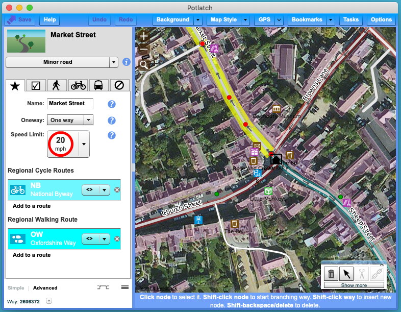
I’m pleased to announce that Potlatch continues to be available, now as a desktop application. You can download it for Mac and Windows at

https://www.systemed.net/potlatch/

Potlatch 3 screenshot

Potlatch 3 includes OAuth login, support for Remote Control, and other features to ease desktop editing. Other new features include support for Overpass API queries in the Tasks palette, and there’s some exciting stuff to come soon… but more of that in due course. As yet we haven’t found a way of reliably running it on Linux but investigations continue.

Potlatch is of course open source. You can get the source and report issues at https://github.com/systemed/potlatch3.

Thank you to the OpenStreetMap Foundation for supporting this work and to Potlatch’s many users for their edits.

Location: Potlatch, Mason County, Washington, 98548, United States

Over the past months, I have spoken to a few different people about the friction that can exist when groups of new contributors engage with OpenStreetMap in areas where there is already existing and active community. Whilst the prompt for writing this diary entry has been recent issues in Panama (between a local YouthMappers chapter and a small group of active local mappers), the content isn’t specific only to that situation and has been informed by multiple people across multiple continents (as well as my own experience).

The issue in itself is also not at all new - I remember if from 2014 when we started the Missing Maps project. What is new is that I now work in HOT’s community team and it’s actually my job to try and work out how to grow the OSM community in a way that respects the past and the future of the project and the community.

You may wonder what the situation in Panama has to do with HOT and I think there are two answers to this.

Firstly, we run the HOT instance of the tasking manager (TM). We see the TM as a community asset and, whilst we don’t originate every project on there (for example, in 2020, HOT originated 17% of all published projects), we do develop and maintain the technology as well as providing the workflows and onboarding for people that want to create and manage specific projects. For example, a majority of YM chapters contribute by mapping through the TM (including the Panama chapter who organised local projects to be set up in collaboration with the global YM team).

Secondly, it is HOT’s mission to radically increase quality local map contributions and contributors from across 94 countries in Africa, Asia and Latin America / Caribbean over the next five years as part of the Audacious project. We need to be good at making sure that new mappers build on what already exists in collaboration with people and communities already actively engaged in the OSM project and that they are welcomed into those same communities.

See full entry

Posted by bo_hot on 31 December 2020 in English. Last updated on 1 January 2021.

To do good, you actually have to do something - Yvon Chouinard

Well today is the day, straightup hackfest. The team will spend the day developing a prototype ready to be tested tomorrow.

We break from the daily structure on this one and the team will break out into smaller groups/pairs to hack together a prototype based on our decision yesterday. This all has to happen in one day, so this is an exercise in effort estimation and making sure we don’t bite of more than we can chew. The goal isn’t to have a refined product, rather something we can use to test our Big Question…

Want us to prototype a solution for your biggest problem? tell us about it here »

away we go

Location: Zetland, Sydney, New South Wales, 2017, Australia
Posted by b-unicycling on 30 December 2020 in English.

The historical society I am a member of does surveys of their main shopping streets about every ten years and I suggested they do one after Covid, because it will affect and has affected the high streets already. They’re not the fastest to realize projects, so I just started already, because OSM will benefit anyway. I’ve done High Street, Kieran Street, parts of Patrick Street and today Rose Inn Street. I’m using a combination of StreetComplete and osmtracker, because StreetComplete doesn’t allow for adding shops etc. But it allows to add housenumbers, which is about time. I’ve noticed that very few shops have their opening hours on the door, so if they’re still open, I usually go in (all masked up, of course) and ask. Sometimes, I have to do that for house numbers as well. I’m looking forward to the streets being less busy (the advantages of lockdown and shops being closed, ironically), because the sidewalks are often very narrow in Kilkenny and surveying takes a lot of time and I don’t like being in the way.

Location: Dukesmeadows, Kilkenny Rural, The Municipal District of Kilkenny City, County Kilkenny, Leinster, R95 P77E, Ireland

2020 is coming to an end and we are all taking a moment to appreciate on the past twelve months. The HOT-Philippines Mapping Team members are hard at work to provide the best quality of data in our field operations and our remote mapping and training activities. To help you look back, we prepared a year-end report that summarizes our accomplishment for the year.

PhilAWARE Project

HOT-Philippines started the PhilAWARE Project last July 2019 which is a local installation of DisasterAWARE, a disaster risk reduction and integrated early warning and decision support system that also incorporates many data layers form OpenStreetMap.

Part of the activities of the project included remote mapping in the province of Pampanga and municipalities of Quezon City and Marikina City. Remote mapping and validation activities for Pampanga and Quezon City have been completed with the help of volunteers, organizations, partners, and other stakeholders while Marikina City is still in progress.

Aside from the remote activities, we also began collecting the data from the ground in the municipalities of Pampanga last August. Our field operations was made possible through the support of the local government offices and volunteers in Pampanga despite the restrictions of COVID-19.

OSMaPaaralan

Alongside the PhilAWARE Project, we supported OSM Philippines’ OSMaPaaralan Project which is an initiative to collaboratively map public schools (paaralan) in the Philippines using OpenStreetMap. Our team is validating location of schools in Pampanga and updating information related to emergencies. If you want to contribute and learn more, head over to the MapRoulette task and help OSM-PH complete the project!

Mapping in a Pandemic

See full entry

Posted by bryceco on 30 December 2020 in English.

The latest version of Go Map!! is now available on the iOS App Store featuring:

  • A new modern look.
  • Updated presets drawn from the recently-independent iD Tagging Schema and Name Suggestion Index projects.
  • Support for a number of languages beyond English (finally!): Russian, Japanese, French, Croatian, Traditional and Simplified Chinese, Norwegian, Finnish and German.
  • Support for Dark Mode.

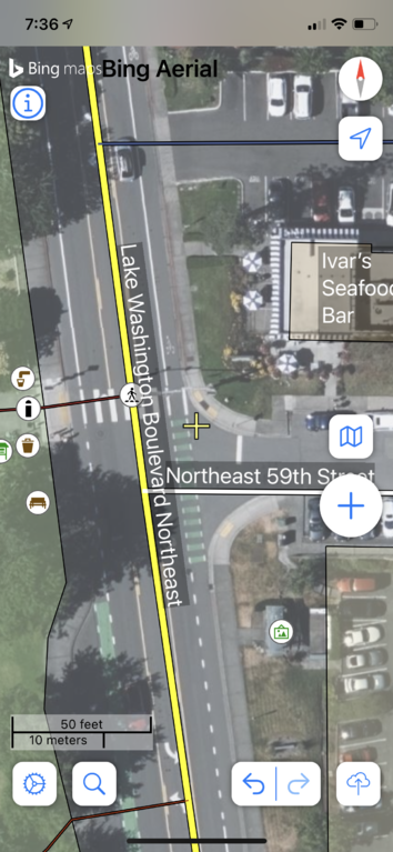
Screen shot

Unfortunately the current tagging of capacity on campsites is ambiguous at best. While on backcountry and scout sites capacity is often seen a the maximum number of persons allowed, on tourist sites mappers often tend to tag the number of pitches available for tents or caravans using this tag.

Thus following a recent discussion on the tagging mailinglist I changed this to be more consistent and similar to existing tags (caravans, tents).

I also changed the bugs view on https://opencampingmap.org/ to warn about the now obsoleted tags capacity and maxtents.

Now mappers should use the following tags instead:

capacity:persons for the maximum number of persons allowed to stay at a site if limited.

capacity:tents for the number of tent pitches available or maximum number of tents allowed.

capacity:caravans for the number of caravan pitches available or maximum number of caravans allowed.

I already changed this in the Wiki for German and English Language.

Please help me changing this in the Wiki for other languages as well.

I also need some help for fixing the localization of https://opencampingmap.org/ for French, Spanish an Russian language. Please contact me if you are a native speaker and can help me with a couple of sentences. Or just send a pull-request for the sourcecode at https://github.com/giggls/opencampsitemap

Posted by bo_hot on 29 December 2020 in English. Last updated on 12 January 2021.

You cannot make progress, without making decisions - Jim Rohn

So, are you sick of reading me yet? Well, the good news is only two days to go. If you’ve been following along or read this far hopefully it’s been useful, or at the very least, tolerable.

Today we decide

I’m going to start by showing an image of how decisions are typically made by consensus.

Decisions

The problem with this approach, is that all the regular voices are heard (typically also the loudest or most relentless ones), if you’re lucky, most people are ok to let the decision move forward (even if they don’t love it) and you end up most probably with a camel (a horse designed by a committee).

See full entry

Location: Zetland, New South Wales, 2017, Australia
Posted by Gustavo22Soares on 29 December 2020 in English. Last updated on 8 June 2021.

I’d like to start giving thanks to everyone who participated in our Mapathons, specially Qeef for developing the DAMN project and Karl Prieb for being that incredible person that keeps mapeia.space working!

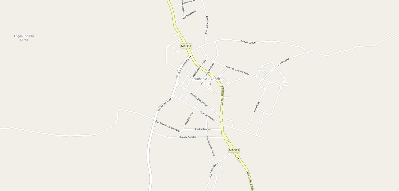
Since the beginning of the year I wanted to map entire cities, starting researching fields, adding unclassified highways of my city and rural buildings, and, of course, I had plans, as some may know, to take this to another level but it turned out that the COVID-19 came. So I started to focus more on what I could do remotely and inf 4 months through our DAMN instance we managed to improve the map considerably, I wouldn’t say that it can be used for projects that need precision, besides the lack of data, satellite images are not the best way to map.

Before

senador-alexandre-antes.png

After

See full entry

Location: Centro, Timon, Maranhão, Northeast Region, Brazil
Posted by SomeoneElse on 29 December 2020 in English. Last updated on 30 December 2020.

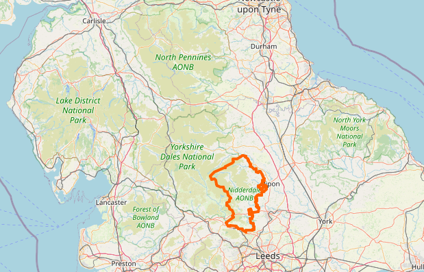
National parks and AONBs in northern England

Occasionally, I (like other people I’m sure) have noticed that things “disappear” from maps they should appear on. In the case of “national parks” and “areas of outstanding natural beauty” in the UK, they’re mapped as multipolygons. This might be simple, like Nidderdale or more complicated, like Ynys Môn. What usually happens is that someone accidentally “breaks” the multipolygon, for example by creating a gap in an outer edge, so that rendering software sees it as invalid and ignores it.

What I’ve typically done in the past is, whenever I’ve noticed a problem tried to find the problem using something like the OSM Relation Analyzer or JOSM’s validator. The “area” view at Geofabrik’s OSM Inspector is also useful.

That works, but “happening to notice a problem” as a first step is not ideal. This map does show national parks / AONBs and not a lot else at zoom 7, but those tiles only typically get updated every 4 days, so it can lag behind problems.

See full entry

Location: Craswall, Herefordshire, England, United Kingdom
Posted by bo_hot on 29 December 2020 in English. Last updated on 12 January 2021.

Drawing is exercise for a restless imagination - Tim Burton

Finally, it’s time to put some pen to paper and start to turns problems into solutions. I can almost hear a collective sigh of relief from some of the hot_tech members, ‘finally time to get hands on’.

Do you want us to sketch a solution to a problem you’re facing? Hit us up here »

For the sole search today, each of us will be undertaking a redux session. Basically a redux session is us o’oking further afield to collect ideas that inspire us toward our solution. We will then prepare these ideas to be shared in the remix session thought ‘Lightning Demos’.

Remix
In our remix session today we will be conducting Lightning Demos. IThrough a three minute tour, each member will share their sole search inspirations and focus on what’s cool and what’s the big idea that may be useful for our Big Question.

And then, for async action we will be putting pencils to paper (yep, actualy paper) and starting to sketch out our individual ideas for our end. Sketches can be simple or sensational, weird or wordy. The main goal is to get an idea into an easy to understand ina structured process for even the least artistic amongst us. It’s a simple as 1, 2, 3…ok, 4.

  1. Notes - You collect notes on all your inspirations and insights.
  2. Ideas - You turn those notes into ideas
  3. Crazy 8s - You sketch like crazy 8 images in 8 minutes
  4. You then choose the one you want to ‘sketch’ for the group and give it (or them) a cool name (which will be important later).

And then today we’re done, for tomorrow we decide!

See full entry

Location: Zetland, Sydney, New South Wales, 2017, Australia
Posted by bdon on 28 December 2020 in English. Last updated on 29 December 2020.

Vector Map Bundles are the follow up to Minutely Extracts which I posted about previously.

map bundle create

You can download map bundles for up to 500,000 nodes at protomaps.com/bundles.

Self-Contained, Batteries Included

Map Bundles are cartographic basemap tile pyramids built from a minutely-updated snapshot of OpenStreetMap. That means within sixty seconds of uploading your changeset, you can download a new Map Bundle and have a self-hostable or offline-friendly zoomable map with those changes.

A Map Bundle includes example HTML and JavaScript code to serve and render the vector tiles in the browser - just run python3 demo.py after you’ve unzipped the ZIP archive. You can even interact with individual elements on the map to view their tags or OSM identifiers.

See full entry

Location: Station Front, Taipei, 10018, Taiwan
Posted by bo_hot on 28 December 2020 in English.

Plan your work, then work your plan - Napoleon Hill

w2, already! And awayyy we to go. We’ve had time to rest, relax and reflect on our insights and surprises. So now what? Now we gotta actually do something…

Which brings us to week 2One of the main reasons I thought a design sprint would work for our team is everyone’s work ethic tuned to tangible, practical solutions. I knew a full 3 months of user research and no building might make the team go something something…

crazy

The great thing about the design sprint is the focus on putting something in the hands of our users.

So let’s start at the very beginning, the very best place to start…the end.

In Monday’s sole search, we have two goals.

See full entry

Location: Zetland, Sydney, New South Wales, 2017, Australia

Hello, everyone!

It’s my first OSM Diary post; please allow me to introduce myself. My name is Jikka and I just joined the mapping community some time during the second half of 2020 through Humanitarian OpenStreetMap Team - Philippines. I’ve long wanted to write an OSM diary entry (I’d already thought about writing something regarding AWS and PhilAWARE) but I wasn’t so sure if my thoughts (a newbie’s!) would be welcome. But, seeing the push for openness and inclusivity made me feel more confident in expressing myself. I’m sure there are people who share this sentiment. 🤗

Anyway, I am writing this just in case any newbie here reads the OSM diary entries. That’s what I did when I joined, and I learned so much from just being a #lurker lol. I’m sharing three trips for any newbie who wishes to contribute:

  1. If you are a newbie (welcome!), please add the hashtag #newbie when making changes and explicitly state in your comments that you are a newbie so that other mappers can guide you. (I’d like to thank arnalielsewhere for this tip!)

  2. That being said, please don’t be discouraged when other mappers add comments or send you direct messages to ask about your recent edits. Whenever they ask questions (usually about data that you ~unknowingly~ changed), just be honest and say you’re learning.

  3. Please join mapathons. It’s always good to have someone answer your questions real time. Lessens the chances of us newbies uploading changes that don’t necessarily improve the map.

The reason why I’m posting this is because we can’t really claim to be making OSM a free and inclusive community when we’re being discouraging to new mappers. Likewise, for newbies, we can’t cement ourselves in the discussion and the movement in general if we’re always discouraged by comments or if we’re intimidated by the system we want to improve.

See full entry

Posted by nickjohnston on 27 December 2020 in English. Last updated on 14 February 2024.

For months I’ve been mapping addresses in Cheltenham, England. I recently discovered the JOSM “Coloured Streets” style. It has improved my address mapping and might help you too.

The style shows streets and all the buildings and address nodes “on” them in the same colour. This makes it easy to spot buildings tagged with the wrong addr:street at a glance. It also clearly shows buildings with addr:housenumber or addr:housename (you must enable the latter in the settings) but no addr:street. (The JOSM validator checks for this too, but with Coloured Streets you can see the problem immediately.)

In this example, Ashcombe House, Outwoods, and Beechwood are in pink and therefore have an addr:street of Stanley Road, when they should be on Ashley Road. The mistake would not be obvious otherwise.

Screenshot of JOSM with the coloured streets style

If you look near the bottom right of this screenshot, you can see Windsor Street shown in orange:

See full entry

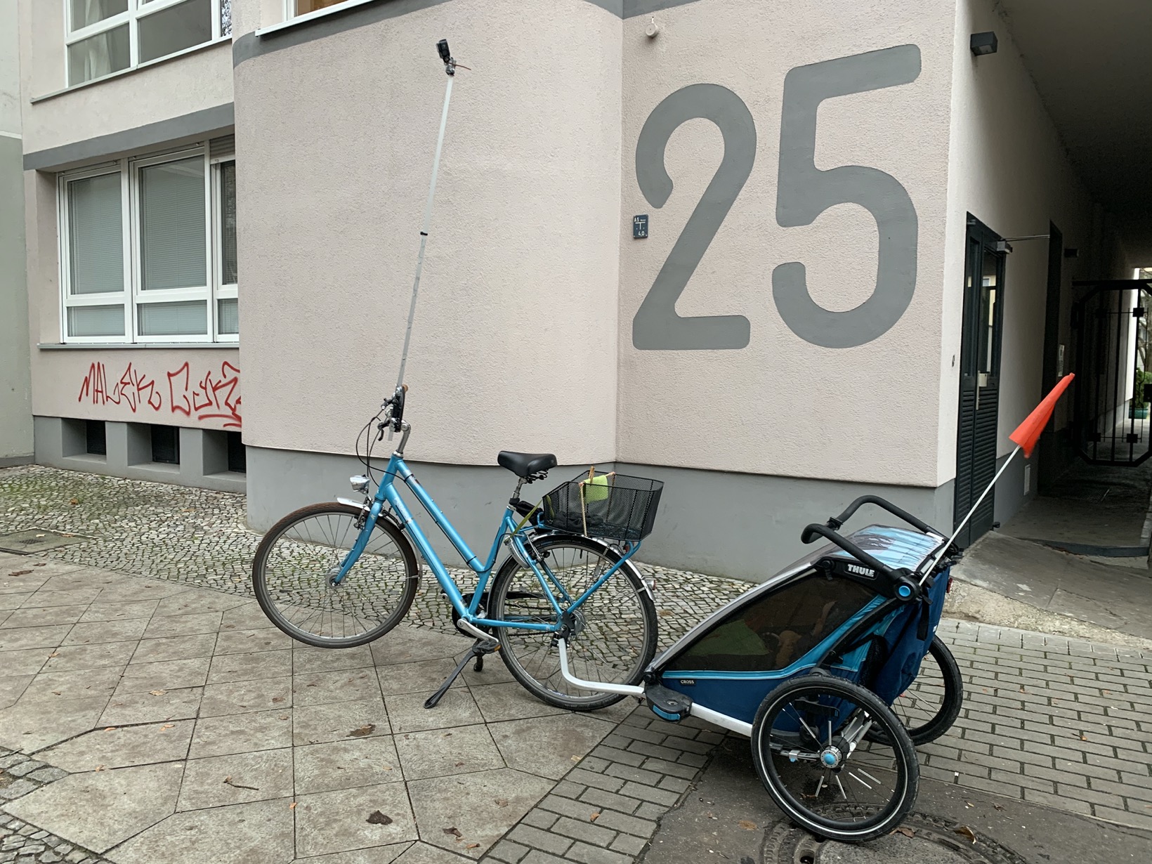
A year ago I started doing a lot of walking and cycling with my stroller. Naturally, I had to look for new ways to contribute to OSM. More on the go mapping – thank you GoMap! – and more passive contributions by providing street level images.

With this post, I want to share my prototype of a bike tripod to take great Mapillary images.

It looks like this:

Picture

Goals of my tripod prototype:

Goal 1: Elevation – Take pictures from as high up as possible

My goal is to create images that allow to map bicycle and pedestrian infrastructure. For Berlin, this requires the pictures to be taken either on the sidewalk itself or from high above on the lane. Otherwise, all you see are parked cars.

Goal 2: Field of view – Look ahead with privacy in mind

No 360°

See full entry

Location: Neukölln, Berlin, Germany
Posted by bo_hot on 26 December 2020 in English.

share

everyone you will ever meet knows someting that you don’t - Bill Nye

So given that it’s Friday and a cultural holiday for many, it seems only fitting that today is share day.

So, I thought that I should take a few minutes out to share a bit about this part of our RaDs.

This day is all about bringing together everything we heard through our conversations. We want to uncover the…
‘the things we don’t know,
the things know that just aint so that just gotta go.

What we do know know is confirmation bias exists so we want to use this as an opportunity not to solve but to surprise.

As we go through our share day we will be undertaking an exercise similar to a Johari Window.

See full entry

Location: Naz, Esserts-Salève, Monnetier-Mornex, Saint-Julien-en-Genevois, Upper Savoy, Auvergne-Rhône-Alpes, Metropolitan France, 74560, France
Posted by bo_hot on 24 December 2020 in English.

enagage

we need to turn up the volume in the silent spaces - Lily Cheng

One thing we really want to focus on during these engage days is to find out a whole lot of things. Summed up by meyrecent foray into poetry.

Hello, I’m Bo,
I know what I know,
But not what I don’t know,
But it’s what I know that just ain’t so,
That’s gotta go.

This is what excites me about engaging and exploring. To question everything I know and be surprised. I want my assumptions to be challenged and my beliefs to disrupted.

So come and make hot_tech question itself, by signing up here.

Location: Naz, Esserts-Salève, Monnetier-Mornex, Saint-Julien-en-Genevois, Upper Savoy, Auvergne-Rhône-Alpes, Metropolitan France, 74560, France