%20by%20Vince%20Emond.jpg)
OSM if full of different characters and identities, so I want to know…
- Who are you?
- What is OSM to you?
- What are you here to do?
 OpenStreetMap
OSM if full of different characters and identities, so I want to know…
Today we have organised a training workshop on OpenStreetMap from Khulna University. Respected, Sawan Shariar ( Regional Ambassador, YouthMappers) conducted this training.
A group of HOT voting members, from across four continents) met on Tuesday evening as part of the HOT board’s strategy committee to discuss perspectives on community definitions and what we mean when we talk about community sustainability. These conversations are really pertinent at the moment as HOT begins to develop and implement the Audacious project, which provides a real opportunity to support local communities to power up as well as generate high quality OSM data in 94 countries.
It was acknowledged that HOT is many different things to different people. It was thought to both be a network or community (including volunteers and contributors, staff, humanitarian data users) and a node in other networks (where it was felt that HOT sometimes plays an important facilitation role). It was also suggested to be a (niche) social network, used for finding and developing information, knowledge, tools and relationships.
It was also perceived as a sub-community of the OpenStreetMap and as an NGO.
Whilst there were many positive attributes associated with HOT (diverse, collaborative, oriented to social good), it was also felt that HOT was sometimes a label applied too easily to contributors and communities in its networks, without thought for how they might define themselves. For example, the use of the phrase ‘HOT community’ to encompass any group doing humanitarian work involving OSM (or ‘HOT edits’ for any OSM contributions through the Tasking Manager) can be perceived as HOT staking an undeserved claim over the work of others and not indicative of a collaborative node in a network.
This afternoon I did front & left camera Mapillary capture around the block in Bandar Bukit TInggi near Healthlane Pharmacy. Unfortunately the usual afternoon rain intervened just after I started capturing. Don’t know whether the images are useable, but I’m uploading it first.
I had trouble using the existing libraries with OAuth. I first started Implementing the methods I directly needed. The size increased and I thought I would be easier to make that a separate Project. Now I’m done Implementing all of the OSM API 0.6 the you find the project at Github or on PyPi I would love to hear some Feedback from you, either here via PM or on github open an Issue.
You can now download a development version of Potlatch 3.0 to run on your desktop.
At https://www.systemed.net/potlatch/download/ , you can download a Mac native app, or an AIR file for use on Windows or (possibly) Linux.
Potlatch 3.0 includes desktop-editing features such as Remote Control support, overview zoom levels, and an OAuth login flow for saving. Rendering is faster and there’s now Overpass API support in the tasks palette.
Installation on Linux is likely to be complex and I’d welcome reports from anyone who has successfully achieved it.
There’s much more to come in future weeks so watch this space. You can report issues at http://github.com/systemed/potlatch2/issues pending the creation of a dedicated 3.0 repository.
Just tested and uploaded streetview of Persiaran Batu Nilam 16 to Mapillary. Looks great and should be able to get more streetviews for improving pedestrian paths mapping. ;-)
Every year during State of the Map, starting in 2016, there has been a Local Chapters Congress session where representatives and members of Local Chapters that have been recognised by the Foundation and other local mapping communities meet together to talk about experiences and challenges in starting, building up, and growing enthusiastic local communities of OSM mappers.
Due to the pandemic, we unfortunately could not hold the Local Chapters Congress this year during the virtual State of the Map 2020 last July. However, the Local Chapters and Communities Working Group, or LCCWG, has decided to push through with a separate virtual event at the end of this year’s OSM Geography Awareness Week! (Trivia: the LCCWG was in fact formed as a result of the Local Chapters Congress 2019.)
_
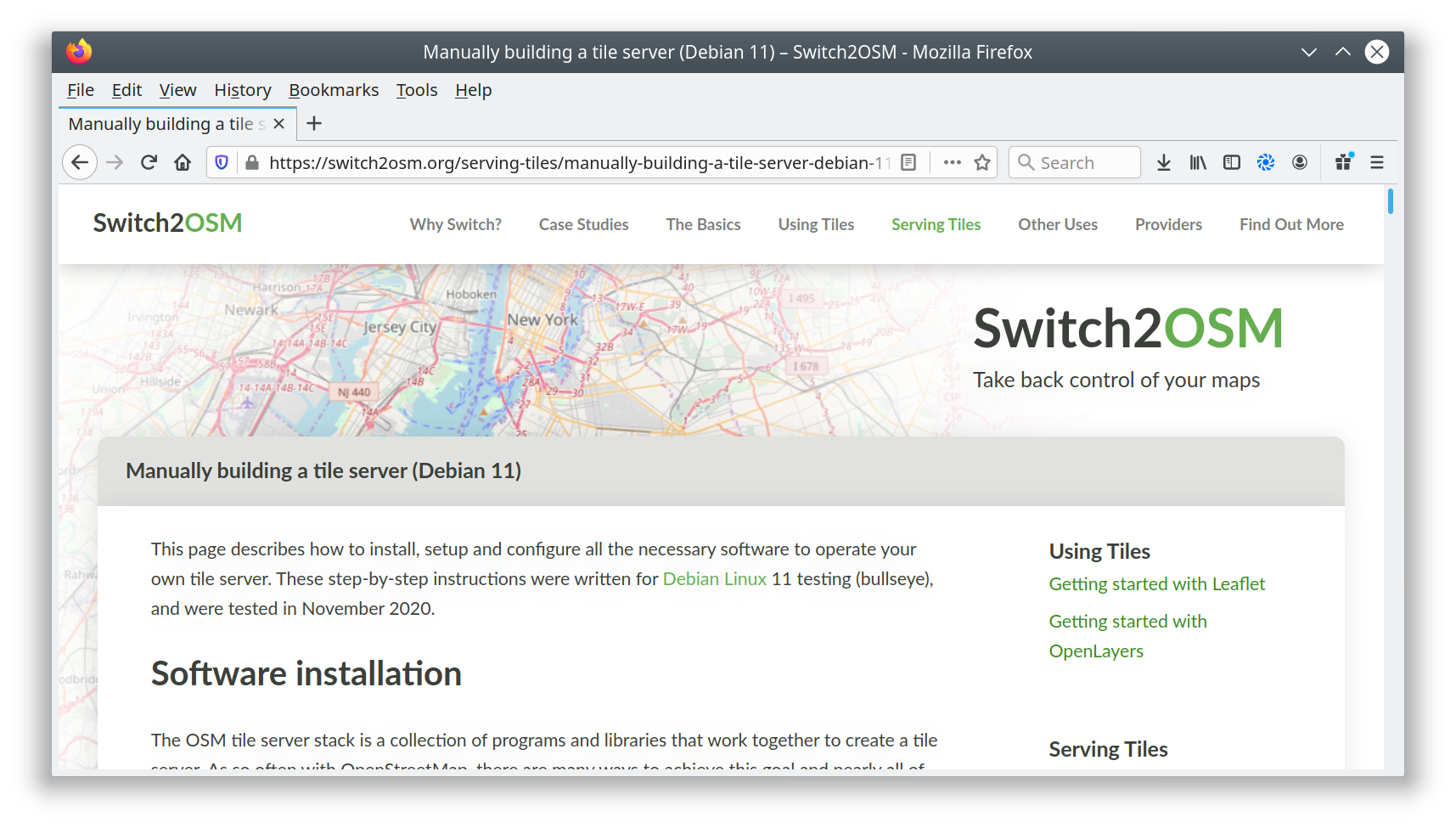
I’ve added a new page to the switch2osm guide: “Manually building a tile server (Debian 11)”. The Debian developers have worked to include the required software inside Debian 11, so there’s actually less setup work needed than in previous versions.
Debian 11 has not yet been released; it’s still “testing”, so there may be minor changes along the path to release. Also, there’s currently a temporary problem with the Natural Earth download site that requires a workaround, but that’s documented in the guide. When that is resolved I’ll update the notes.
I’ve not yet linked the new page into the menus because I want to give people a chance to test it and identify any problems first. Once that’s happened, I’ll add it to the “Serving Tiles” menu.
The difficult 3rd post is here with little to say. I am sitting in a little flat in Bellingen looking out at the hills and trees. I am on holiday. I am enjoying this moment.
Fossgis is sponsoring the CMS and Mattermost Server for the weeklyOSM Editorial team for several years now. Last week they sponsored a server update (a 4GB server).
As OSMBC is keeping history similar to OSM, the number of managed article has increased to nearly 24k articles. Currently 70 users are listed as editors and nearly 700 are guest users. With the update Fossgis supports the weeklyOSM team in their work.
But my main thanks goes to the weeklyOSM team, which now serves the their news in 14 languages.
Christoph
My previous smartwatch, a Fitbit Ionic died after swimming. While I have used it to log walks it really wasn’t suitable for navigation.
I replaced it with a Garmin Instinct. It is very oriented (see what I did there) for navigation on top of the regular fitness and as a wearable device to interact with a smartphone. It turns out that Garmin makes extensive use now of Open Streetmap for planning routes (or courses as they refer to it for the watch) and waypoints (or saved locations). It incented me to help fill in some gaps in my local area after doing a bushwalking and re-exploring areas after the terrible 2019 bushfires.
Task done today. Got back login access on OSM and OSM-wiki. ;-)
Here’s some of the things I’ve been doing in OpenStreetMap in October 2020.
Added detail from my Mapillary photos and imagery
Did you know that OSM data is available as an open dataset on Amazon Web Services? Updated weekly, the files are transcoded into the .orc format which can be easily queried by Amazon Athena (PrestoDB). These files live on S3 and anyone can create a database table that reads from these files, meaning no need to download or parse any OSM data, that part is done!
In this post, I will walk through a few example queries of the OSM changeset history using Amazon Athena.
For a more complete overview of the capabilities of Athena + OSM, see this blog post by Seth Fitzsimmons. Here I will only cover querying the changeset data.
From the AWS Athena console, ensure you are in the N. Virginia Region. Then, submit the following query to build the changesets table:
CREATE EXTERNAL TABLE changesets (
    id BIGINT,
    tags MAP<STRING,STRING>,
    created_at TIMESTAMP,
    open BOOLEAN,
    closed_at TIMESTAMP,
    comments_count BIGINT,
    min_lat DECIMAL(9,7),
    max_lat DECIMAL(9,7),
    min_lon DECIMAL(10,7),
    max_lon DECIMAL(10,7),
    num_changes BIGINT,
    uid BIGINT,
    user STRING
)
STORED AS ORCFILE
LOCATION 's3://osm-pds/changesets/';
This query creates the changeset table, reading data from the public dataset stored on S3.
To get started, let’s explore a few annually aggregated editing statistics. You can copy and paste this query directly into the Athena console:
SELECT YEAR(created_at) as year,
      COUNT(id)        AS changesets,
      SUM(num_changes) AS total_edits,
      COUNT(DISTINCT(uid)) AS total_mappers
FROM changesets
WHERE created_at > date '2015-01-01'
GROUP BY YEAR(created_at)
ORDER BY YEAR(created_at) DESC
I will break down this query line-by-line:
City of Yathrib
.jpg)