Diary Entries in English

Recent diary entries

8925 COVID-19 - YELIMANE CERCLE 3 - KAYES REGION, MALI

HOT has been requested by OpenStreetMap Mali and the Mali Red Cross to map areas in Mali susceptible to, or identified as impacted, by the COVID-19 outbreak. Please join our global effort to help control this disease by mapping on this project.

Globally HOT is committed to fighting COVID-19 by providing 3 critical services:

Helping government agencies and responders with basic data needs: we’re providing this through the UN’s Humanitarian Data Exchange, among other ways. Helping to Identify populations living in places most at risk: prioritizing our existing queue of mapping projects to get volunteers immediately mapping areas with high proportions of COVID-19 cases, or of greater vulnerability. Creating new mapping projects in highest risk places; which is what this project does. Every feature you map will help in this objective! The goal of this project is to digitize the buildings using MAXAR Premium Imagery.

Spent 1 hour mapping buildings and roads.

Posted by katpatuka on 26 June 2020 in English.

I think I was really 6 months busy in Sichuan adding missing towns, townships and subdistricts with their English name and wikipedia/wikidata tags. Not only on osm but also on zhwiki and wikidata I added lots of stuff…

China’s administrative infrastructure is crazy! In urban regions a lot changed in December 2019: townships were upgraded to towns and towns in subdistricts. Some counties became districts or county-level cities. Sometimes places get a new name even. And that wasn’t necessarily immediately reflected in zhwiki because zhwiki is still blocked in China! So you are always playing catch-up…

China is developing very fast and the biggest problem for us mappers is: missing up-to-date imagery ! Sometimes I had to use 10 year old imagery from one provider because imagery from other providers were cloud covered. No usable GPS traces - only maybe for main trunk or primary roads. At least there are more Chinese users now editing on OSM…

I stopped checking Chengdu urban centre - too tiring - and I hate big cities ;)

Location: Kuailong, Dachuan, Lushan County, Ya'an, Sichuan, China

Greetings!

Please, find a link to an archive with my code, inputs and resulting “open_in_JOSM_and_upload.osm”-file below: https://drive.google.com/file/d/14ECmeyQN8HMrITfcsa3Nw3BfAv8Fi687/view?usp=sharing

Despite the name of the resulting file – “open_in_JOSM_and_upload.osm” – this file has attribute [upload=’never’] which should prevent accidental upload of it. But, just in case, let me make it explicit: THE FILE “open_in_JOSM_and_upload.osm” IS PRODUCED ONLY FOR REVIEW BY OSM COMMUNITY, IT MAY CONTAIN SERIOUS ERRORS, PLEASE, DO NOT UPLOAD IT!

The archive also includes a README .pdf-file that describes in simple language my approach to matching address points with OSM buildings.

The script file, “import_sf_addresses.py”, should run in a standalone mode (like “python3 import_sf_addresses.py”) if you have all required libraries installed, but I ran it step-by-step.

Should you have any questions, I’d be happy to reply. Looking forward to receiving your feedback!

With kind regards, Yury Yatsynovich

Phew, I think I’ve finally finished off the highways and significant residential areas this subdivision of East Timor. It’s really taken some time, partly because I’ve had time away from mapping, and partly because it was a massive job. It would look better with more forests, mountain peaks, rivers and other geographic features marked as much of it is quite high inaccessible land, and that would make it clearer (as always). Still, this is counter mapping for me, missing maps, putting people who aren’t on any map, never mind digital maps onto an open source one that they have even the possibility of adding to or correcting.

Location: Tukarocoiloeo, Hatu-Builico, Ainaro, East Timor

The category “Construction” under Infrastructure has been split into three sub categories:

  • Construction sites: landuse=construction, highway=construction, building=construction, railway=construction and all items with a tag prefixed with ‘construction:’.
  • Proposals: landuse=proposed, highway=proposed, building=proposed, railway=proposed and all items with a tag prefixed with ‘proposed:’.
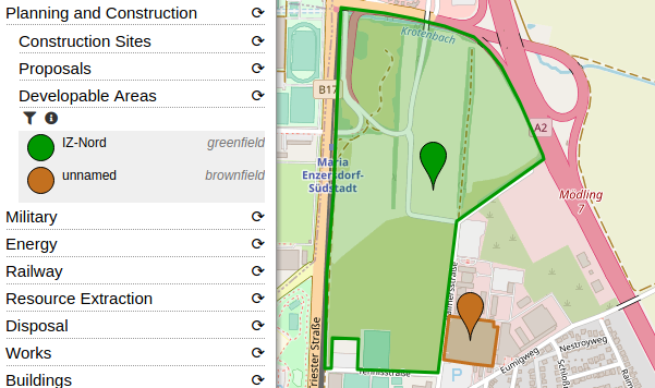
  • Developable areas: landuse=greenfield and landuse=brownfield.

Further updates:

Example of the “Developable Areas” category: Image showing a screenshot of OpenStreetBrowser with a greenfield and a brownfield highlighted

Posted by GoodClover on 23 June 2020 in English. Last updated on 4 July 2021.

The school near me was rebuilt a few years ago, and it was bugging me how it shows on maps as the old one, or both overlapped. I’ve now fully updated it on OSM :)

Update: Seems this got me into OSM! I’ve micromapped the school now, and am glad that I decided to start mapping.

Location: Willerby, East Riding of Yorkshire, Hull and East Yorkshire, England, United Kingdom

Note: this is an English version of my article in French here.

I’m a long time contributor of Mapillary and probably one of the top contributors in Wallonia. I have uploaded 59,7 k images to Mapillary, covering +1000 km. I have contributed of course with road imagery taken from my car, but also on the train and on several hundreds km of tracks and paths. While Mapillary has a good coverage in cities, it is usually poor in rural areas and I was happy to contribute on hiking trails, where I thought it has some potential for tourism applications. Beside Mapillary, I’m actively promoting OpenStreetMap as a hobby but also with my company as a GIS professional. With my colleagues or as OSM contributor, I made several trainings on OpenStreetMap to various publics: tourism agencies, urban planners, students, environmental agencies. At almost every OSM training / mapping parties, I also advocated for Mapillary, as an alternative to Google Street View, just as OSM is an alternative to Google maps. Two years ago, my colleague and I were invited as “open-source geo experts” to a meeting at the Walloon road administration to speak about the potential use of OSM and Mapillary for monitoring the 10k’s of signposts in the Walloon region (17,000 km²). So I was a also a advocate of Mapillary just like I’m a strong advocate of OSM, both in my local mapping community and professionally.

Was. Then I saw this news: Facebook acquired Mapillary. I had first mixed feelings. I took some days to think if I should stop contribute to Mapillary or not. I even still uploaded some guidepost images taken this weekend. But finally I took the decision to download all my images and delete my Mapillary account. Why?

See full entry

map note and comments June 20 2020:

Resolved note #2189641 Description

Il sentiero finisce li, per piacere rimuovete le segnaletiche e sulla mappa please. è molto pericoloso…. Created by Enzo Trekking guide about 1 month ago Resolved by jaimemd less than a minute ago

Report this note

See full entry

Location: Sanza, Salerno, Campania, Italy

8921 | Médecins Sans Frontières (MSF)

MISSING MAPS: NIZI REGION, DEMOCRATIC REPUBLIC OF CONGO

MSF is assisting in an Indoor Residual Spraying (IRS) campaign in the Nizi region in Ituri in the Democratic Republic of Congo. During this campaign insecticides will be applied on the inside of dwellings where malaria infected mosquitos rest. As a result the number of mosquitos will go down, which prevents the transition of Malaria.

Spent 1 hours mapping buildings, road and paths.

Posted by Joe Bucket on 21 June 2020 in English.

so my Grandad was born in Den Amstel and it’s where his remains are now but uppon looking there’s nothing there! in fact there’s not at all in Guyana and even less of has been mapped

So I took it upon myself to start mapping as many villages as possible along the river starting with Den Amstel due to the link with my Grandad

I have completed an overhaul of Turkmenistan’s municipalities in the OpenStreetMap database. All cities are identified, plus all but four towns (those pesky four are still hiding), and 256 out of 481 “village councils” are now on the map, as well as 504 out of 1,717 “villages” known to exist. If anybody knows offhand where the four missing towns (şäherçeler) are located, please drop me a line.

Each geolocated village now also has addr:city tags so we know to which municipality it is subordinate (this is important because so many village names are used over and over again), as well as addr:district tags to aid in identification.

Misnamed municipalities or those with obsolete names have been corrected or updated, and old_name tags have been added where appropriate. Mapillary key numbers for images of signs have been added in several cases to assure positive identification.

On the wiki, the “Turkmenistan Geoname Changes” page features a list of cities and towns with hyperlinks to their respective nodes and ways on osm.org, and “Districts in Turkmenistan” features a list of villages with the same for them, wherever a village has been geolocated. This will ease finding specific municipalities by province and district.

I spent a bit more than four years mapping Turkmenistan en situ and did not want the accumulated knowledge to go unused, hence this effort to get everything I learned into the database..There is still more to do: 1,213 villages remain unidentified, and those four towns are out there somewhere. But this is a good start, and the map is in much better shape than it was in 2015.

Location: Ak bugday District, Ahal Region, Turkmenistan
Posted by floridaeditor on 20 June 2020 in English.

Just 6 months ago, Florida was absolutely littered with incorrectly tagged trunk roads (i.e. US and state highways tagged as trunk rather than primary). The rendering of Florida looked like a bloodshot eye, and correctly tagged trunk roads (i.e. Pineda Causeway, US 27 in Everglades) were mixed with incorrect ones. The problem was made even worse by an editor who mainly edited the California area, by tagging correct primary roads as incorrect trunk roads[a].

To standardize the tagging of trunk roads in a general ‘east’ location[b], a general ‘trunk road in the East US guidelines’ was agreed upon:

  • Road must have very few to no at-grade intersections (about 5 per county/parish);
  • Road may or may not be divided (contrary to motorway);
  • Road may be any speed;
  • Road may have any designation;
  • Road may or may not allow foot traffic, cycle traffic, etc.

Following the agreement of these guidelines, I set off to change Florida’s trunk route scheme. First I started with US 192/CR 15 (now tagged as primary/secondary) and just kept going, until finally Florida was clean[c]!

But it wasn’t done.

No, sir, we need a general tagging scheme in place for county, state, and non-designated streets. Putting guidelines in place (mainly following California’s with tweaks), I set off with Brevard and Orange counties in mind to fix. I am currently working on those projects.

Of course, this is not the only thing I do. If I go geocaching, I might add some park features at the park it was in. I might improve waterways[d], other businesses, etc. But my main focus continues to be on CR/SR/non-designated roads.

  • [a] Standards differ between California and Florida.
  • [b] TODO: east of Mississippi or straight down the center?
  • [c] Fixing such a large state wasn’t easy, but it took about 3 months.
  • [d] One of such edits turned out to be controversial, but it was cleared up.
Location: Oak Ridge, Orange County, Florida, 38209, United States
Posted by krahulreddy on 18 June 2020 in English.

Comparison:

For indexing the nominatim data, we have two major contenders- Solr and Elasticsearch. Both are based on the Apache Lucene library and provide a wide range of search options. As a part of my GSoC project, a comparison of both of these has been done. A small project was set up to compare the functionality offered.

We have listed a few requirements for this project:

Required

  • Indexing: Name, Postcode fields.
  • Handle multiple names -> eg:- OSMNames
  • Handle postcodes
  • Scoring based on importance(0-1).
  • Handle data update
  • Store but do not index: Type, Class, id
  • Avoid copy fields

Desirable

  • Normalization
  • Tokenization for suggestion improvement
  • Consider browser defaults for language
  • Typo tolerance

The following table is a brief description of the results of the comparison of Solr and Elasticsearch for our requirements. This table also contains brief information about how different parts will be implemented.


See full entry

Posted by asturksever on 18 June 2020 in English. Last updated on 1 August 2022.

According to IBB Municipality dataset, Istanbul has 183.10 km cycleways and 37 km shared cycleways. Only 46 km cycleways were mapped on OpenStreetMap. These 183.10 km cycleways are in pretty good condition however it is only a drop in the ocean in for metropolitan city to become a cycling-friendly.

I’ve created a Maproulette task to complete cycleways in Istanbul. 142 tasks needed to be mapped on OpenStreetMap. I’ve collected street-level imagery alongside cycleways around old town and enjoy the nice weather.

Alt text

Mapping Cycling Paths in Istanbul is completed on Mmaproulette . Thanks, IBB Municipality datasetsharing data. Big kudos to @OpenstreetmapTr and especially Nesim helped a lot for completing this project. Check his OSM profile out: osm.org/user/Nesim/

Maproulette task: https://maproulette.org/admin/project/4518/challenge/13639

See full entry

Today we announced that Mapillary has joined Facebook with our missions to map the world converging. This is a significant step forward in the Mapillary journey which many of you have been an instrumental part of. Our decision to join Facebook allows us to build upon our efforts to map the world. We’ll have the resources and scale to help support the collection of street-level imagery while applying computer vision that will greatly increase the quantity and quality of map data available for OpenStreetMap.

The OpenStreetMap community has been an integral part of Mapillary since we began, so I’d like to share our perspective on what this change means for OpenStreetMap and why we’re so excited for the next step in Mapillary’s journey.

A collaborative model

Since Mapillary began in 2013, we have sought to build a collaborative platform where images and computer vision are used to map the world. The OpenStreetMap community was quick to embrace Mapillary and see the potential street-level images have to build better maps. Here are just a few examples of the community has been using street-level imagery:

  • Ballerup, Denmark: neogeografen has uploaded millions of images in Ballerup and surrounds which he uses to map cycle paths, street-lighting, and points of interest.
  • Dar es Salaam, Tanzania: The Humanitarian OpenStreetMap Team and the Ramania Huria project made use of Trimble’s advanced 360º camera to collect imagery and map flood resilience characteristics.
  • Xayaboury, Laos: The World Bank has been working with Laos’ Department of Transportation to build and monitor roads in Xayaboury province. Imagery helps ensure the roads are mapped in OpenStreetMap during and after the construction phase.
  • Padova, Italy: The state of urban accessibility was mapped using 10,000 images and meetings with citizens and associations. This project proved the viability of data collection, analysis, and policy advocacy with OpenStreetMap and Mapillary as primary tools.

See full entry