Diary Entries in English

Recent diary entries

OpenStreetMap and Linux are pretty similar in a lot of ways. The licences are both copyleft, require attribution, and allow modification and re distribution. Both projects have a foundation to look over them, but are relatively hands of on day to day operations. Both foundations have corporate sponsorship to fund them.

However when it comes to edits, the projects differ. Linux is now hugely dominated by paid developers, OSM is almost exclusively volunteers. One reason for this may be because most downstream users of OSM use it exclusively as a base map, they use there POI data on top and then almost laughably link to Google Maps for directions. They are only using a tiny portion of OSM. (And they are missing out!)

Lots of Linux contributors are paid employees of a business, usually tasked with fixing or implements a specific thing. As far as I know only Amazon does this in OSM, paying employees to fix routing issues. Sometimes this is closer to having a benefactor, where the business pays the employee to work on what ever they want and the benefactor trusts it’s in the best interest over all. Mark Shuttleworth ran Ubuntu as a loss for a long time, they contributed to the whole ecosystem during that time. I guess Mapbox might have the finances to be able to be a benefactor, but other than them there doesn’t seem to be a lot of money around.

Some developers are founded directly through other people on platforms like Patreon. I don’t think this is a massive in the kernel space, although a few high profile developers for other projects do it. You would then get the freedom to spend your time how you wanted, working on projects that interest you. This is similar to having a benefactor although you have to spend a significant amount of time and effort marketing yourself, and being your own PR. I don’t know if OSM has a big enough crowd to support this.

See full entry

Posted by OpenBrian on 7 June 2020 in English.

What’s Microcosms

Microcosms is a upcoming feature in the OpenStreetMap website to support local communities of mappers. Each microcosm is focused on a city and has a team of mappers working on improving OpenStreetMap in that city. The microcosm can organize their upcoming events and track RSVPs.

microcosm
noun
mi·cro·cosm | \ ˈmī-krə-ˌkä-zəm \
Definition
1. : a little world
2. : a community or other unity that is an epitome of a larger unity
source: Merriam-Webster

Development

Work started last year and is picking up lately. During development, microcosms is a fork of OSM called osm-microcosms. There’s a PR for early feedback from the website team.

The website team has a high standard for quality and I appreciate that. I continue to write automated tests for all the new code I create.

A design document is available to get an idea of what’s done and what’s to come.

Community

The Local Chapters and Communities Working Group has taken an interest in Microcosms and I’m glad to provide something to support them. Check them out on Matrix.

I’ll be giving a talk in the OSM US series of Mappy Hours. I’m scheduled for June 9th. And I’m talking to Austin about being on his podcast Nodes and Ways.

User Feedback

Thanks to Tom on the OSMF Operations Working Group we have a beta website for user feedback.

I’d love to hear what you want in Microcosms. What’s working well? What’s working poorly? What features are missing? Please file your issues and I’ll work on them.

OSM Testing Site: Microcosms


Brian DeRocher is the organizer of MappingDC.

Posted by apm-wa on 7 June 2020 in English.

As of this morning I hit 15,000 edits. I am methodically plowing through the wiki’s “Districts in Turkmenistan” list of villages, identifying them on the map wherever they are, and adding a link to the node or way of the village on OSM. That will make it easier for me to identify which villages remain to be mapped as I seek to complete the map of Turkmenistan from my armchair.

Posted by AmeliaMap on 7 June 2020 in English.

HOT is mapping Cusco region in Peru at the request of regional government to support their COVID-19 response efforts. The maps will be used to provide cash transfers to families who are prevented from working by the quarantine and State of Emergency in Peru, and to provide nutrition and sanitation assistance.

Additionally, in parts of Cusco, over 75% of children under 3 years old suffer from anaemia. This means that their brains will not develop as quickly as other children, and once they start going to preschool and later school, they will often be tired, unable to concentrate or to learn effectively. The regions which suffer most from anaemia are usually the most remote, hardest to reach areas, where data available to local authorities and NGOs is minimal and access to health services for women and their children are limited. The Regional Government in Cusco wants to combat this by geo-locating where children under 3 live in order to improve the medical attention that they receive.

Spent 1 hour mapping Buildings and Roads

Thank you OpenStreetMap for bringing mapping into the open source copyright free domain. I live on the coast near Half Moon Bay California. I am going to use open street maps as part of a project to reduce the amount of fossil fuel CO2 burned during the daily commute.

Question for the OpenStreetMap community. Can a mapper show me how to draw directional arrows or simple vector fields driven by numerical weather data? One component of this project is to measure local atmospheric Carbon Dioxide concentration and see if I can estimate the quantity of fossil fuels being burned locally. Thanks OpenStreetMap I

Question for the OpenStreetMap community, Has anybody got some working Python code for generating turn by turn driving directions? A second part of the same project is to do ride matching so a small number of electric vehicles can enable a great reduction in the CO2 emitted during the daily commute. OpenStreetMap is a no charge map and it can be annotated with ride share information. Thanks again.

Location: Princeton-by-the-Sea, El Granada, San Mateo County, California, 94019, United States
Posted by Wynndale on 4 June 2020 in English.

During lockdown it’s been difficult for me to go long distances to map; instead I’ve tried to fill in every house in the SW14 postal district, consisting of East Sheen and Mortlake, where only about half of them had been mapped before; I realised I could fit ground surveys into the allowed daily exercise. I have also tidied Mortlake station, which had been a complete mess, and completely redrawn the landuse polygons northeast of the level crossing, which had previously put retail in the wrong place.

Location: 51.465, -0.267
Posted by qeef on 4 June 2020 in English.

I run load testing with locust.io on the damn server, and I think it’s usable for mapathon with 100 mappers.

The damn server is part of the Divide and map. Now. – the damn project I have published at the beginning of the year. And I am still interested in the performance. I was wondering if I can simulate a mapathon event.

Setup

I run the damn server on $5 per month VPS of do.co. The server runs Debian 10.2 x64, 1 vCPU, and 1GB / 25GB Disk. There is nothing special about the deployement I described in the last diary.

For load testing, I prepared the area. I uploaded a big area (JOSM measurement plugin says it’s 42 852 square km) with the damn manager, that split it to 654 squares.

Then, I simulated a mapathon in the locust file. The “participating” test mapper can choose from:

  1. Get the area and all its commits. (In fact, all commits wouldn’t be used in a real client twice, since since for an area is implemented.)

  2. Request a random square for mapping. If the square is available, work on it for between 1 and 5 seconds and then stop with need more mapping (30 %), split the square (10 %), or ready for review (60 %). (In the brackets, there is a probability of stop reason used.)

  3. Request a random square for review. If the square is available, work on it for between 1 and 5 seconds and then stop with need more mapping (30 %), please, review again (10 %), or done (60 %).

When (1), (2), or (3) finishes, wait for between 1 and 2 seconds and choose again. (2) and (3) are chosen five times more often than (1).

Testing 100 mappers

I tested for ten minutes. There were ten new mappers per second until a maximum of 100 mappers.

  • Median Response Time: 2900 ms
  • Average Response Time: 6052 ms
  • Min Response Time: 177 ms
  • Max Response Time: 70272 ms
  • Requests/s: 12.10

The total request count was 7 310. And there was no error!

Testing 500 mappers

See full entry

Before, only manually configured websites would be recognized by OSM Smart Menu.

Now, any map website within a set of common patterns will be recognized, even if they are not within the current list of configured/supported websites.

For example, the parameters from https://opengeofiction.net/#map=4/-15.13/-53.19 are recognized, even though this website is not available as an option in the menu.

PS: This is a new feature, so you may find some bugs. Please tell me if you want a specific bug to be fixed soon.

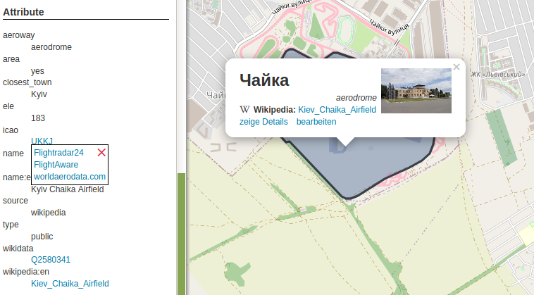
The latest feature update brings links to tag listings of an object. There are a variety of tags which will be converted to links: first of all website, url, phone and similar, but also wikipedia, image and wikidata. Finally the “Tag2Link” rules (JOSM also uses this under that name) are imported from Wikidata and OSM Sophox. In some cases there are multiple possible links, which will be presented in a small popup to let you choose an appropriate provider (as you can see in the screenshot for the ‘icao’ tag). OpenStreetBrowser listing tags of an aerodrome

Posted by n76 on 3 June 2020 in English.

I have been a fairly avid hiker for decades would like to make sure that the trails that I use are properly mapped in OpenStreetMap. As I render my own maps this is doubly important to me.

But there is some ambiguity in how this should be done.

First, the OSM terms/tags of footway and path are not really used in my dialect of English. Second, OSM tag names and values are more code words, somewhat based on UK English, with OSM.specific meanings. It might be easier if something like “h1” were used as a value rather than, say, “trunk”. Then the baggage of your own local dialect of English would not get in the way.

We have sidewalks or walkways and we have trails. While we do use the word path we don’t use footway. At least not in everyday usage.

  • Sidewalks and/or walkways are usually in urban or suburban areas. They are generally hard surfaced with concrete being the most used surfacing material though compacted crushed rock bound with an acrylic binding material may be used in more “park like” areas. They are level and smooth enough that you can easily walk on them with flip-flops while pushing a stroller.
  • Trails are almost always multipurpose. While hiking may be the predominant use most trails are also open to bicycles and equestrian use. Within US Federally designated wilderness bicycles are not allows but trails are usually still shared use between equestrians and hikers. Note that while bicycles are allowed on most trails, it would be folly to try to ride them with anything other than a mountain bike. In addition there are trail systems specifically set up for “off highway vehicle” (OHV) use. They are called trails but you will find dirt bikes and other ATVs rather than hikers, equestrians and bicyclists.

OpenStreetMap Wiki

With that in mind we look at the various tagging defined in the OpenStreetMap Wiki that might be appropriate.

See full entry

Halo saudara/i semua , perkenalkan saya Dwi Fanny, saat ini saya melakukan penelitian tentang mapper aktif yang menggunakan OpenStreetMap sebagai platform dijitasi peta.

Saya sangat berharap kesediaan Saudara/i meluangkan waktunya sebentar untuk mengisi kuisioner dibawah ini: https://bit.ly/Kuisioner_Mapping_OSM

Atas segala perhatian dan waktunya saya mengucapkan terimakasih banyak.

Best regards Dwi Fanny

Posted by Linus Wolf on 1 June 2020 in English.

Charles de Foucauld’s Dictionnaire abrégé touareg-français de noms propres “Abridged Tuareg–French dictionary of proper names” is not only a valuable gazetteer of the Tuareg-inhabited central Sahara, but also a historical source capturing a time when European understanding of Tuareg toponymy had not yet taken on a life of its own.

One example of this divergence between traditional usage of local native speakers, and European reception, is the name and possibly the extent and nature of the Ăhaggar.

The Ăhaggar, clearly and unanimously, is a mountain range or mountain massif. In the early 1900s, Ăhaggar is also attested as the name of a country containing the Ăhaggar mountains. To my knowledge, the usage continues today (in the sense of a land, perceived as culturally or socially distinct, though not politically independent).

In Europe, it’s also known by the name Hoggar, a form which came about through contact with Arabic. Besides, the central part of the mountain massif is often introduced to tourists as the Atakor, apparently also giving rise to the geologically defined area of the Atakor volcanic field. Some overlapping area is now also protected as the Ahaggar Cultural Park.

I’d like to first and mainly look at the historical explanations given in Foucauld’s Dictionnaire, which are interesting as approximations to the local usage prior to major European (or other foreign) influence. After that, I’ll also go over some representations of the Ăhaggar in online databases.

The historical usages

The mountains

According to a first entry in Foucauld’s gazetteer, the Ăhaggar is …

la région appelée proprement Ăhaggar est le massif montagneux central du pays des Kel-Ăhaggar, massif de forme ovale, […] qui est compris entre 23° et 23° 30′ lat. N. et 2° 50′ et 3° 40′ long. E.

See full entry

Location: Tamanghasset, de Tamanrasset District, Tamanrasset, Algeria
Posted by jgpacker on 31 May 2020 in English. Last updated on 1 June 2020.

Now you can disable/enable specific websites in OSM Smart Menu.

How can you access the configuration page?

  • In Google Chrome, right-click the OSMenu button, and select “Options”;
  • In Firefox Desktop, right-click the OSMenu button, select “Manage Extension” and go to the “Preferences” tab;
  • In Firefox Mobile, go to “Extensions”, and then select “OSM Smart Menu”.