Diary Entries in English

Recent diary entries

Thank you OpenStreetMap for bringing mapping into the open source copyright free domain. I live on the coast near Half Moon Bay California. I am going to use open street maps as part of a project to reduce the amount of fossil fuel CO2 burned during the daily commute.

Question for the OpenStreetMap community. Can a mapper show me how to draw directional arrows or simple vector fields driven by numerical weather data? One component of this project is to measure local atmospheric Carbon Dioxide concentration and see if I can estimate the quantity of fossil fuels being burned locally. Thanks OpenStreetMap I

Question for the OpenStreetMap community, Has anybody got some working Python code for generating turn by turn driving directions? A second part of the same project is to do ride matching so a small number of electric vehicles can enable a great reduction in the CO2 emitted during the daily commute. OpenStreetMap is a no charge map and it can be annotated with ride share information. Thanks again.

Location: Princeton-by-the-Sea, El Granada, San Mateo County, California, 94019, United States
Posted by Wynndale on 4 June 2020 in English.

During lockdown it’s been difficult for me to go long distances to map; instead I’ve tried to fill in every house in the SW14 postal district, consisting of East Sheen and Mortlake, where only about half of them had been mapped before; I realised I could fit ground surveys into the allowed daily exercise. I have also tidied Mortlake station, which had been a complete mess, and completely redrawn the landuse polygons northeast of the level crossing, which had previously put retail in the wrong place.

Location: 51.465, -0.267
Posted by qeef on 4 June 2020 in English.

I run load testing with locust.io on the damn server, and I think it’s usable for mapathon with 100 mappers.

The damn server is part of the Divide and map. Now. – the damn project I have published at the beginning of the year. And I am still interested in the performance. I was wondering if I can simulate a mapathon event.

Setup

I run the damn server on $5 per month VPS of do.co. The server runs Debian 10.2 x64, 1 vCPU, and 1GB / 25GB Disk. There is nothing special about the deployement I described in the last diary.

For load testing, I prepared the area. I uploaded a big area (JOSM measurement plugin says it’s 42 852 square km) with the damn manager, that split it to 654 squares.

Then, I simulated a mapathon in the locust file. The “participating” test mapper can choose from:

  1. Get the area and all its commits. (In fact, all commits wouldn’t be used in a real client twice, since since for an area is implemented.)

  2. Request a random square for mapping. If the square is available, work on it for between 1 and 5 seconds and then stop with need more mapping (30 %), split the square (10 %), or ready for review (60 %). (In the brackets, there is a probability of stop reason used.)

  3. Request a random square for review. If the square is available, work on it for between 1 and 5 seconds and then stop with need more mapping (30 %), please, review again (10 %), or done (60 %).

When (1), (2), or (3) finishes, wait for between 1 and 2 seconds and choose again. (2) and (3) are chosen five times more often than (1).

Testing 100 mappers

I tested for ten minutes. There were ten new mappers per second until a maximum of 100 mappers.

  • Median Response Time: 2900 ms
  • Average Response Time: 6052 ms
  • Min Response Time: 177 ms
  • Max Response Time: 70272 ms
  • Requests/s: 12.10

The total request count was 7 310. And there was no error!

Testing 500 mappers

See full entry

Before, only manually configured websites would be recognized by OSM Smart Menu.

Now, any map website within a set of common patterns will be recognized, even if they are not within the current list of configured/supported websites.

For example, the parameters from https://opengeofiction.net/#map=4/-15.13/-53.19 are recognized, even though this website is not available as an option in the menu.

PS: This is a new feature, so you may find some bugs. Please tell me if you want a specific bug to be fixed soon.

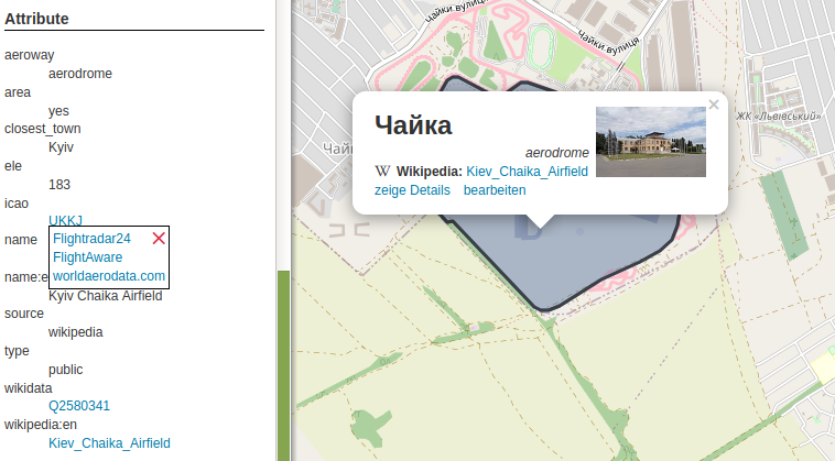
The latest feature update brings links to tag listings of an object. There are a variety of tags which will be converted to links: first of all website, url, phone and similar, but also wikipedia, image and wikidata. Finally the “Tag2Link” rules (JOSM also uses this under that name) are imported from Wikidata and OSM Sophox. In some cases there are multiple possible links, which will be presented in a small popup to let you choose an appropriate provider (as you can see in the screenshot for the ‘icao’ tag). OpenStreetBrowser listing tags of an aerodrome

Posted by n76 on 3 June 2020 in English.

I have been a fairly avid hiker for decades would like to make sure that the trails that I use are properly mapped in OpenStreetMap. As I render my own maps this is doubly important to me.

But there is some ambiguity in how this should be done.

First, the OSM terms/tags of footway and path are not really used in my dialect of English. Second, OSM tag names and values are more code words, somewhat based on UK English, with OSM.specific meanings. It might be easier if something like “h1” were used as a value rather than, say, “trunk”. Then the baggage of your own local dialect of English would not get in the way.

We have sidewalks or walkways and we have trails. While we do use the word path we don’t use footway. At least not in everyday usage.

  • Sidewalks and/or walkways are usually in urban or suburban areas. They are generally hard surfaced with concrete being the most used surfacing material though compacted crushed rock bound with an acrylic binding material may be used in more “park like” areas. They are level and smooth enough that you can easily walk on them with flip-flops while pushing a stroller.
  • Trails are almost always multipurpose. While hiking may be the predominant use most trails are also open to bicycles and equestrian use. Within US Federally designated wilderness bicycles are not allows but trails are usually still shared use between equestrians and hikers. Note that while bicycles are allowed on most trails, it would be folly to try to ride them with anything other than a mountain bike. In addition there are trail systems specifically set up for “off highway vehicle” (OHV) use. They are called trails but you will find dirt bikes and other ATVs rather than hikers, equestrians and bicyclists.

OpenStreetMap Wiki

With that in mind we look at the various tagging defined in the OpenStreetMap Wiki that might be appropriate.

See full entry

Halo saudara/i semua , perkenalkan saya Dwi Fanny, saat ini saya melakukan penelitian tentang mapper aktif yang menggunakan OpenStreetMap sebagai platform dijitasi peta.

Saya sangat berharap kesediaan Saudara/i meluangkan waktunya sebentar untuk mengisi kuisioner dibawah ini: https://bit.ly/Kuisioner_Mapping_OSM

Atas segala perhatian dan waktunya saya mengucapkan terimakasih banyak.

Best regards Dwi Fanny

Posted by Linus Wolf on 1 June 2020 in English.

Charles de Foucauld’s Dictionnaire abrégé touareg-français de noms propres “Abridged Tuareg–French dictionary of proper names” is not only a valuable gazetteer of the Tuareg-inhabited central Sahara, but also a historical source capturing a time when European understanding of Tuareg toponymy had not yet taken on a life of its own.

One example of this divergence between traditional usage of local native speakers, and European reception, is the name and possibly the extent and nature of the Ăhaggar.

The Ăhaggar, clearly and unanimously, is a mountain range or mountain massif. In the early 1900s, Ăhaggar is also attested as the name of a country containing the Ăhaggar mountains. To my knowledge, the usage continues today (in the sense of a land, perceived as culturally or socially distinct, though not politically independent).

In Europe, it’s also known by the name Hoggar, a form which came about through contact with Arabic. Besides, the central part of the mountain massif is often introduced to tourists as the Atakor, apparently also giving rise to the geologically defined area of the Atakor volcanic field. Some overlapping area is now also protected as the Ahaggar Cultural Park.

I’d like to first and mainly look at the historical explanations given in Foucauld’s Dictionnaire, which are interesting as approximations to the local usage prior to major European (or other foreign) influence. After that, I’ll also go over some representations of the Ăhaggar in online databases.

The historical usages

The mountains

According to a first entry in Foucauld’s gazetteer, the Ăhaggar is …

la région appelée proprement Ăhaggar est le massif montagneux central du pays des Kel-Ăhaggar, massif de forme ovale, […] qui est compris entre 23° et 23° 30′ lat. N. et 2° 50′ et 3° 40′ long. E.

See full entry

Location: Tamanghasset, de Tamanrasset District, Tamanrasset, Algeria
Posted by jgpacker on 31 May 2020 in English. Last updated on 1 June 2020.

Now you can disable/enable specific websites in OSM Smart Menu.

How can you access the configuration page?

  • In Google Chrome, right-click the OSMenu button, and select “Options”;
  • In Firefox Desktop, right-click the OSMenu button, select “Manage Extension” and go to the “Preferences” tab;
  • In Firefox Mobile, go to “Extensions”, and then select “OSM Smart Menu”.

Luckily, I’m well connected with the right people (at least in this case), and people know my obsessions about benchmarks and field names. I had been surveying Cramersgrove in Co. Kilkenny and a friend said that “we” (in this case Kilkenny Archaeological Society) had a c 1815 Coghill Estate map in our archives with field names on it. Again luckily during lockdown, I have a key to the archives, because I was doing some work there at the beginning of lockdown, so I had a root around. The problem with those maps is that they are all rolled up and you don’t know what’s on them until they’re unrolled and not all of them are labelled. But I found the right one! And it does have field names on it and some match the ones I got from the farmer who lives there now. His great-grandfather must have been purchasing that land about the time that map was made. That should be well out of copyright and I should be allowed to add the historical names. If there is a tag…

The field with the pin is Bonnahilla on the 1816 map. A bit of a different spelling to Bawn na haille.

Location: Grove or Cramersgrove, Kilkieran, The Municipal District of Castlecomer, County Kilkenny, Leinster, Ireland

It occured to me today that when “we” are out inquiring about field names from farmers, we usually only get the names on the farm we are on or maybe neighbouring farms. I think what is very important to consider is asking the wife in the house (if she’s not already the informant) about her homestead. It’s likely that she grew up on a farm as well. And she could be from some remote area that the surveyor (“we”) is not likely to get to any time soon.

Of course you have to be prepared for that eventuality. Going out to the farm with FieldPapers of that farm won’t be any use for the wife from further afield (pun not intended). Taking a laptop, praying for good broadband and using OSM there and then might be the better strategy. If she doesn’t remember, she might still have a brother or nephew on the home farm. Once the contact is established, a FieldPaper atlas could be sent to him. She will be able to explain it to him in their own words rather than in our mappers’ lingo.

This is all academic so far; I haven’t had a chance to try it. Yet.

I’ve added a couple of short but interesting scripts to github. They fetch and sort posts from an OSM mailing list from some time in the past. For example, here are the topics on the talk list at the height of the licence change furore:

listtopics.sh talk 2012 May

 35  OSM : It's a shame !!!
 24  Edit review: ele=0
 22  Worst of OSM
 21  TomTom is thumping us
 17  Import of buildings in Chicago
 17  Edit review: intermittent waters
 16  OSM cycle map - ?excessive focus on long-distance routes
 15  Edit review: "building"="levels=N"
 14  Cycleways and Access tags: Left, Right, Forward, Backward?
 10  OpenSeaMap
 10  Cycle lanes & cycle tracks - my findings and a proposal
  7  Changing capitalization (Lima)
  6  OWL down
  6  OSM data density - top regions
  6  Old versions of OSM?
  6  Copy-and-paste remapping
  5  TTTracklog and TomTom core 9.4
  4  OSMCoastline / OpenStreetMapData.com
  4  Mapnik rendering issue with *_link roads
  4  (dis)Honesty and Copyright

and here’s the tagging list today:

See full entry

Posted by eneerhut on 28 May 2020 in English. Last updated on 1 June 2020.

Hi everyone,

There have been conversations in the OSM community about creating a more formalised group to coordinate OSM activities in the region. This would be important step to getting recognition as a local chapter of the OpenStreetMap Foundation which would in turn allow us to collaborate more closely and potentially be eligible for grants and support going forward.

By formalised group, we were thinking of a working group that would be part of OSGeo Oceania. An initial discussion was initiated here. Please note that this application relates to the application we made to the OSMF to have OSGeo recognised as a local chapter.

FOSS4G SotM Oceania 2019 in Wellington, New Zealand FOSS4G SotM Oceania 2019 in Wellington, New Zealand

Some of the objectives of a working group we discussed include:

See full entry

Location: Melbourne, Victoria, Australia