Posted by PhysicsArmature on 1 April 2020 in English.

(Subject says it all) If the GPS that got uploaded was accurate, I would be running off road, across driveways, on sidewalks that are not yet built.
 OpenStreetMap
(Subject says it all) If the GPS that got uploaded was accurate, I would be running off road, across driveways, on sidewalks that are not yet built.
I drive a Tesla Model 3 around Canberra suburbs. When it uses Traffic Aware Cruise Control, it apparently relies on OSM data rather than the speed limit signs. This can lead to situations where TACC will use an incorrect speed limit (eg. 80 km/h in a 60 km/h zone). See osm.org/way/668268353#map=19/-35.24389/149.13545&layers=TD How can such speed limit data be kept accurate and up to date? This is what I aim to find out.
The Frei-Otto-Straße of Munich, 80797, Germany has been operational for the last couple of weeks. Please find the addresses here: Straßen-Umbenennung in Frei-Otto-Straße_2020-01-16.pdf
Hi All,
I thought it was about time I started my diaries and put some public thoughts out into the world of OSM.
I recently joined HOT to take on the role of Director of Technology and couldn’t be happier to be a part of it. I am by no means replacing my predecessor, Nate, rather doing my best to carry on and evolve the astounding legacy (and huge shoes to fill).
In the spirit of openness, you can look up my background here > https://www.linkedin.com/in/bopercival/
My HOT profile is here > https://www.hotosm.org/people/bo-percival/
the tldr; I’ve always worked in non-profit, NGO and community development and have worked over the past 7 or so years specifically on digital development, ICT4D or whichever turn of phrase you’d prefer. Over the last 5 years, I also worked alongside a couple of OpenSource projects in this space namely DHIS2 and Moodle. Things I care a lot about; design, inclusive technologies, gender & LGBTQI+ groups, transparency and universal access.
I’ve been a long time user of OSM in a recreational capacity (finding and contributing mountain bike and hiking trails while living in and around Asia), but I’m new making contributions in a professional capacity.
I have two personal mottos. i) ‘support the superstars’ and ii) ‘the best opportunities in the best interests of others’. My main goal is to facilitate and support the team at HOT as well as everyone in the OSM community to ensure all voices are heard for HOT’s contributions.
This article sums up me and combines my work life with my non work life > https://www.linkedin.com/pulse/leadership-development-backcountry-guide-way-bo-percival/
Feel free to reach out to me on slack or email, I’m always open for a chat, feedback, ideas, anything you’d like :)
One of the main feature I love to map while hiking are abandoned houses/isolate dwellings. It’s full of them in the parks I usually go around and they are more often than not in a good state. Leaving aside the fact that after a few years I’m STILL not sure what the exact tag should be (locality? isolated_dwelling? abandoned:isolated_dwelling?) the main “problem” I have is with the one I don’t reach: there are so many abandoned places marked on OSM that have no road/path leading there. I suppose most of them come from mass import from public data-set or maybe someone copying data from other maps, but it baffles me how many un-mapped way are there in the mountains. I love exploring and I would love to complete some zone, but it seems like an effort so huge that feels impossible.
South and east of Torsetvannet a new diagonal was opened winter 2019/20 that is not currently in opensnowmap. This now added. It does not yet have a name so noe has been added. The track is groomed with classic tracks on both sides and a narrow skat section in the middle, thus taged as classic and skate.
I saw a tender put out for new aerial imagery for Regina. It looks like the city is keeping with their recent pattern of re-imaging the city every 2 years. The images are usually acquired early to mid April before the tree leaves open.
Should be available for JOSM editing in a few months to add buildings constructed in the past year.
Many places around the world right now are experiencing community lock downs to help mitigate the spread of CoVid-19. Non-essential travel is restricted or banned, including even exercising outdoors.
That’s our new normal here in the Philippines, especially those villages, towns, and cities in Luzon under “community quarantine”, or the more restrictive “enhanced community quarantine”, in other words we are staying at home as much as possible, and most us are online doing many other things, trying to keep our minds of from worrying.
In fact, I recently enrolled to an online language course, to brush up on my Nihonggo, which I took up many years ago, but never really got to use except, for my perfect “Wakarimasen” replies. 😉
Last week, the OSM community in the Philippines kicked of a re-formatted MapaTime initiative. In our previous normal, MapaTime events are mapathon sessions held in venues where people physically gather to contribute, learn, map, exchange ideas about specific themes, or initiatives. It’s a term we use, instead of the jargon “mapathon” which many people may not understand, based on feedback we received from past sessions.
This initiative is referred to as “WeMap”, a portmanteau of “Wednesdays MapaTime” , where we plan to organize sessions every Wednesday night, hoping to reach out to online volunteers who are keen to contribute to positive efforts, with tangible outcomes during the lock down.
HOT is mapping Cusco region in Peru at the request of regional government to support their COVID-19 response efforts. The maps will be used to provide cash transfers to families who are prevented from working by the quarantine and State of Emergency in Peru, and to provide nutrition and sanitation assistance.
Additionally, in parts of Cusco, over 75% of children under 3 years old suffer from anaemia. This means that their brains will not develop as quickly as other children, and once they start going to preschool and later school, they will often be tired, unable to concentrate or to learn effectively. The regions which suffer most from anaemia are usually the most remote, hardest to reach areas, where data available to local authorities and NGOs is minimal and access to health services for women and their children are limited. The Regional Government in Cusco wants to combat this by geo-locating where children under 3 live in order to improve the medical attention that they receive.
Spent 1.5 hours mapping buildings, roads and paths.
Labeled Meridian Kennels.
Labeled and described 4870 Will-T RD. -SM
Praying for the world !! Hope everyone is safe out there .. God Bless
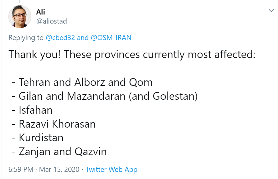
I recently reached out to the OSM Iran community on Telegram, who are normally writing in Farsi and have made some incredible map improvements lately. I first came across their work in 2019 when I noticed the community on Twitter showcasing incredible detail on pedestrian paths and gardens in Iran. I’ve always wanted to visit Iran, but found myself instead getting second hand stories about the landscape and culture, and frequenting Persian restaurants when living in places like California.
In the recent weeks, I began reading about the extreme strain on the medical system in Iran in reaction to COVID-19, and I asked a fellow user who was relaying information from his family and friends there if he could tell me what areas appeared most affected. His tweet response set me off on a mission.
In these days of social isolation, at least here in Belgium, we’re still allowed to wander in our neighborhood. One way to make that a little more interesting: collect all the paths! I mentioned this on Twitter, and was asked to make a tutorial. So here goes.
The general idea: make a map showing all the paths in your neighborhood. Then go and visit them all, and visualize which ones you have visited. Over time, you’ll see what direction you should be heading to add more paths to your collection.
No dataset contains as many paths as OpenStreetMap. You can see them on your smartphone (e.g. on Osmand, on the main OpenStreetMap website, or on whatever style of map you like.
For this project, we want to download the data itself. Assuming we’re just downloading a little area, we can use the awesome Overpass Turbo for this.
I’ve prepared this sample query for you. Just move the map to your neighborhood, and click Run. Don’t zoom out too much, as loading all this data might crash your browser. Here’s a lighter query (in case you get a timeout; this one doesn’t exclude private roads).
Now you have a clear map of your data. But you can’t edit it here. So first, let’s download the data. Just click “Export”, then “Download as GeoJSON”.
Above is the link to a recent Diary from CjMalone with info on using osm.mathmos.net to obtain a list of all the UK schools mapped in OSM within a particular Postcode, ordered by how well they correspond to the UK gov.uk site.
I’m a pensioner and am supposed to slowly rot within my home without any socialisation with any other human. So, no change there. However, whilst we are in that Lockdown state — I’m over 70, and therefore have been instructed by the government to stay isolated at home — I may as well do something useful. I’m currently working my way through NG, and have just completed the 28 Nottinghamshire schools that osm.mathmos.net could not match up with a school at all. That has taken me 3 days. Phew! I’m either superb in my coverage or (far more likely) just very slow.
If using JOSM, then a useful shortcut is to enable Remote Control (Preferences: f12|Remote Control (LHS vertical column icon)|click in tick-box for 'Enable Remote Control'). Within your Web Browser, be sure to disable all Script restrictions for OSM, else there can be no inter-connection. Then, with JOSM launched, and whilst logged in to your OSM account in a browser, and with the relevant part of the map active (for me at this instance: osm.org/way/55316126), click on the browser Edit drop-down and choose Edit with Remote Control. You can now switch to JOSM and that Way is waiting for you to edit it. Be sure to disconnect the Remote Control facility after use unless you want your computer to (possibly) be open to the internet.
I have realized people map what is important to them in higher quantities than other things. Thus you find the areas they have mapped over the areas they don’t map. People map the areas the know more about than the areas they don’t, thus looking at edit clusters can show where people live. Finally the tag local knowledge as a source shows where someone has been. Combining these all together can be used to track people down.
Since July 2019, Jongole State of Upper Nile region in South Sudan has experienced devastating flooding, which has led to millions of people displaced from their residential areas and moving to refugee camps in the neighbouring countries and within the country in search for safety and clean environment for human life.
Spent 1 hour 15 minutes mapping buildings and paths.
In the UK, the brand “Carphone Warehouse” is closing all of its standalone mobile phone branches, and only having concession stands / counters inside “Currys PC World” stores.
When it comes to adding / updating Carphone Warehouse to OSM, is there any OSM tag that can be included with a Carphone Warehouse node that’s placed on or within a Currys PC World, that indicates it is actually inside a Currys PC World? e.g. ‘is_in:Currys PC World’, ‘inside:Currys PC World’ or ‘location:Currys PC World’?
Or would placing a node on / within a Currys PC World be enough to indicate it’s inside the building?
Alternatively, would it be better to tag Currys PC World with a particular tag that indicates it contains a Carphone Warehouse inside, or even updating the name tag to “Currys PC World Carephone Warehouse”, rather than having a separate node for Carphone Warehouse?
After updating lots of opening_hours changes, as well as adding new delivery options and takeout only tags, I realized that I was missing a subset of food resources: food banks and soup kitchens.
With so many people likely not able to get to work, these resources may be more heavily relied upon than normal and knowing where these resources are, and when they are open, will be very important to people. I even added the free bag lunch, snack, and breakfast for kids from the school system.
If these resources are available in your area, but aren’t on the map, I encourage you to do the research and put them on the map!
-> https://www.openstreetbrowser.org/
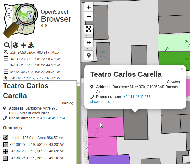
The toolbar in the sidebar now includes a globe symbol. It will show information about the current view and highlight the view center with a crosshair.
When activating GPS location, your location will be highlighted. Also, details will be included in the toolbar panel.
The details of map features show geographic information about the object: coordinates, length and area (when applicable).
In the Options you can configure coordinate formats and unit systems.
Also, in the Options you can select which editor will be used, when clicking the ‘edit’ button in a map feature popup.
For all translators: there are quite a few strings which need translation in the User Interface category.


%20by%20Vince%20Emond.jpg)


