Diary Entries in English

Recent diary entries

Posted by Supaplex on 30 January 2020 in English. Last updated on 31 January 2020.

I want to talk about the things of tagging of OpenStreetMap multilingual name that was not convenience to mention about when I give a talk.

The first thumb of rules is do not mechanical edit place where there is a active community, place like Europa. Your edit might got rolled back if in serious condition due to the nature of mass modification, some one report that some problem occur. I use the CC0 license Wikidata item that does not include coordinate data, just the sitelink of different language version of Wikipedia. Sometimes the Wikipedia article name and the name previous added on OpenStreetMap is quite different, if you just replace with the Wikidata data, you are in trouble when European community found out.

Compare to Europe, editing in China or the US does not encountering much obstacle. The former one community is much small, there are so much place and administrative relation has not been edit of multilingual, even has the form of Chinese name plus English name in parentheses of name field, which usually stands for local name. The latter one is due to the fact American are mostly monolingual people, not doing so much on add multilingual. If you want to go to a trip to the US, you might spending time to add the language you familiar. So it is a easy task to using Wikidata multilingual data as a source, adding it on OpenStreetMap in the US and China.

See full entry

So I had two helpful commenters on my journal offer two pieces of advice from my last entry. In addition, there’s also one other avenue I’m going to try.

1. User Traces

  1. There is this thing called “User Traces”. When enough users add traces, it gives you a rough mean of where the roads are in relation to the imagery.

image

What I was able to find was a couple lines on First, which is expected for a small town.

2. Strava

Strava is a social network for runners and the like. I’m not terribly familiar with them, but apparently, they have offered permission for their heat map of users to be overlaid on ID and JOSM. Possibly. Don’t quote me. However, like anything web, these alliances are short and fleeting. Here is a quick summary of the two tickets which offer the current state of affairs:

https://github.com/openstreetmap/iD/issues/4896 https://josm.openstreetmap.de/ticket/16100

See full entry

Location: Ladysmith, Cowichan Valley Regional District, British Columbia, Canada
Posted by Minh Nguyen on 27 January 2020 in English. Last updated on 5 February 2020.

I’m running for reelection to the OpenStreetMap U.S. board. I’ve been contributing to the OpenStreetMap project as a volunteer since April 2008, mostly as a mapper and an advocate for the project. (My day job, writing iOS software at Mapbox, also intersects with OSM to some extent.) Last April, you elected me to the board to fill Maggie Cawley’s seat after she became our executive director. Thank you for taking a chance on me – I’d be humbled to continue to serve the community in this capacity.

I like to think I left things a little better than I found them. By the time I began nine months ago, board meeting minutes hadn’t been published publicly for over two years. As secretary, I’ve published minutes of each monthly meeting as soon as the board approves them at the following meeting. It may be some of the least exciting stuff I’ve ever written for the Internet, but published minutes are an important way for the OSMUS organization to stay in touch with its members. In conjunction with the monthly newsletters that I can’t take credit for, you know what’s on our radar and – just as importantly – can find out if something isn’t. Whoever wins this election, I hope the board will keep up the momentum. (If you have any feedback about the contents of these minutes or know of something else the board should take up, please let us know.)

Robert’s Rules aside, I could tell you about my work to train new mappers, improve documentation, advise on tagging proposals, and moderate thorny disputes, each of which have picked up to some extent over the past year. But the truth is that none of these activities strictly requires a seat on the board. What a seat on the board affords is a platform to steer the organization and use it to promote a vision for the broader project.

My ongoing priorities for OSMUS, which I outlined in my previous position statement, can be summed up as building=yes bridge=yes. (Building bridges, get it?)

See full entry

Location: Farmington Hills, Oakland County, Michigan, United States

Spent 1 hour and completed mapping all buildings in several sectors.

Project Details #7772 - Missing Maps: Delta Amacuro, Venezuela

A worrying consequence of the decline in Venezuela’s health system is the rise in preventable diseases such as malaria. Especially the coastal areas of Venezuela are extremely vulnerable. The data you contribute will help MSF respond better to health needs in the area.

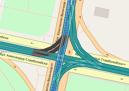
A current update allows symbols to use the scale of the current map view for parameters (e.g. for width or offset of lines). To demonstrate these features, the “Railway gauge” category now shows the rails with the correct offsets (although the exact configuration for multi-gauge rails is neither mapped nor evaluated) (available from zoom level 18). Code.

Map showing single and dual gauge tramway tracks in Sofia, Bulgaria Map showing single and dual gauge tramway tracks in Sofia, Bulgaria

Details: * The value map.metersPerPixel, which measures the size of the pixel at the viewport center in meters, is now available for twig templates. From this you can calculate the width or the offset of a line in meters. E.g. you could use {{ max(5, 3 / map.metersPerPixel) }} as value for width: 3 meters, or at least 5 pixels. * Related to the first feature, you can now also specify the value of certain style parameters (width, offset, …) with a unit: ‘px’ (for screen pixels) and ‘m’ (world meters).

See the README.md for details.

Posted by Heather Leson on 26 January 2020 in English.

Over the past years, we’ve hosted sessions at State of the Map, we had some online discussions, and the diversity mailing list provided a space for some discussion and planning. The work of Geochicas has done tremendous headway on what might be possible.

Here are some of the ideas around Diversity that were collected from a small group that met between 2016 - 2018:

Opportunities

  • OSM Women Chapter- space, mailing list
  • Code of Conduct, guidance for OSM
  • Consultation spaces - SOTM global, SOTM Asia, Digital
  • Co-Created Draft - what is needed in it
  • Implementation - How to get there
  • Timeline between 2 - 3 years

Programmes

  • Gender-sensitivity training for men / coaching & mentoring for male allies
  • Focus on recognition / celebration of women’s accomplishments (versus just opening up positions that have “duties” associated for example)
  • Review and revise historical narrative of how OSM / HOT came to be to be sure to include the contributions of women who helped pioneer it but have been overlooked (OSM wiki page?)
  • More mapping campaigns around issues of women & girls
  • Talking points, recipes for diversity to assist supporters
  • Ambassadors to help guide the tone to positive and inclusive [HOT resolution process(osm.wiki/Humanitarian_OSM_Team/Working_groups/Community/HOT_Resolution_Process)
  • Promote more leadership by women and individuals from underrepresented places

Challenges

  • Tone of the mailing list
  • Backlash
  • History of the community / momentum
  • Bureaucracy of OSM, Working Groups
  • Vote approved?
  • Enforced how?
  • Cultural differences / communication, language
  • Lack of familiarity with gender and inclusion best practices
  • Timezones
  • To keep evolving as the challenges that OSM faces continuously change, along with the challenges that women face change too

Actions

See full entry

Location: Plainpalais, Geneva, 1205, Switzerland
Posted by Antoine Logean on 25 January 2020 in English.

Hi,

The satellite image of the place where I am born (Wallis in Switzerland) is cloudy. How often will be this satellite image updated? What can we do to accelerate this process? If I ask the Wallis canton if they are willing to donate to OSM a more recent satelite image, could we use it? What is the normal process here?

Kind regards

Antoine

Location: Les Prasses, Vex, Hérens, Valais/Wallis, 2305, Switzerland
Posted by Minh Nguyen on 25 January 2020 in English. Last updated on 8 March 2026.

(This post is cross-posted from a recent post on my blog and adapted for an audience already familiar with OpenStreetMap.)

A year ago, I was pretty sure I’d be spending all my free time mapping buildings and turn lanes. I did contribute plenty of them, but I also have a tendency to get distracted by ideas out of left field. During the past year, I wound up focusing on several kinds of features that never make it onto conventional maps. At some point, I took up mapping flags.

A taboo

The first atlas I owned as a kid was The Picture Atlas of the World (Kemp & Delf). The beautifully illustrated maps and infographics endeared this volume to me for years, but it was the colorful ring of national flags around the front cover that made it irresistible to me at the bookstore. It’s a wonder that my parents gave in to my pleas and purchased this atlas, despite the “red flag” of the Socialist Republic of Vietnam gracing the cover. My grandparents fled the Communists in the ’50s, and they with my parents fled the Communists again in the ’70s. Like many refugees, they longed for Vietnam – especially after searching in vain for Vietnamese food – but hearing about life there today, good or bad, would often elicit dismissive eye-rolling about the Communists.

See full entry

Location: Little Saigon, San Jose, Santa Clara County, California, 95116, United States
Posted by freebeer on 24 January 2020 in English.

It seems recently the OSM tile CDN has started answering over IPv6.

So perishes my quick check whether I’m connected via an IPv6-only network, where osm.org/ used to show a blank map on the rest of the homepage, and I know immediately a workaround is needed. Always was my second action after connecting to https://ipv6.google.com/intl/en/ipv6/statistics.html .

In other words, yay, now to give forum.osm the same connectivity, and a few external sites, then I can catch up with OSM without paying attention to how I’ve been connected.

Posted by CjMalone on 23 January 2020 in English.

As with everything in OSM, quality varies massively by location. Around my area, and lots of the UK, the state of bus stops has been neglected. Around a decade ago there was the NaPTAN import, with a few nit picks I believe it was a good thing. OSM needed bus stops, NaPTAN had bus stops, the answer is obvious, import.

However we have let that data go stale and get out dated. A surprising amount of the bus stops, haven’t been touched in the 10 years+- since the import. They still have naptan:verified=no. They have old names. Take a look at osm.org/user/NaPTAN/history, pick a changeset, pick a node. Was it last edited about 10 years ago by NaPTAN? That’s an issue. Maybe somebody realigned it based on satellite imagery, that’s still an issue.

The NaPTAN import was a static thing. A one time event. But the NaPTAN data isn’t, they record and publish when a bus stop is changed, it’s name changed, it gets deleted, moved. Why can’t we keep on top of this data? I know OSM is very against automatic edits, for one reason or another. So I’ll just flat out ignore that, even though I disagree.

So we should be manually keeping in sync with NaPTAN, one way to do this is to download the NaPTAN data for a region and sort it by newest modified date. Compare it to the OSM data, does it have a new name? Has it location changed? Has it plain been removed due to route changes? Do we need re survey the bus stop? To download NaPTAN see that page.

Please, everyone who reads this, do an overpass query in your local area, the bus stops need your help.

Not verified:

node["highway"~"bus_stop"]["naptan:verified"="no"];

No NaPTAN ref:

nwr["highway"~"bus_stop"][!"naptan:AtcoCode"];
nwr["public_transport"="platform"]["bus"="yes"][!"naptan:AtcoCode"];

See full entry

Posted by LarryFeltonJ on 23 January 2020 in English.

I intend to do edits on Cobb County Georgia, but I’m very new to this. One thing I noticed immediately is that “Veterans Memorial Highway” has been mislabeled “Veterans Memorial Parkway.” I edited one instance of the label, but I’m not yet sure that it took, or that it covered all instances. I’ll muddle through the documentation and figure it out, though.

I’m starting with South Cobb (Mableton/Austell) because that’s where I live, but plan to work my way northward up the county.

Location: Johnstons Crossing, Mableton, Cobb County, Georgia, 30369, United States

Hy everyone, I just wanna share my experience on how I really need the spatial data in OSM or other Map Platform. Basically, it began when I was on a trip to the overseas and wanna find an outdoor park that has some pull-up bar so I can start my workout morning routine. It really hard to find a single spot like this one in my map application. I decided to walk outside and found some pretty good spot to begin my workout but unfortunately it for private access for the apartment. I believe there are so many people out there like me, struggling to find a good spot for workout whether they are in their home neighbourhood or in the new area that they never visited before. with the power of OSM, I already start mapping some of this healthy spot since last month in Malaysia and Indonesia. Mostly the objects I mapped are pitch and some outdoor park that I know there are some sports tools that can be used. Here my idea of what object we could map in OSM related with healthy spot :

See full entry

Location: RW 07, Tebet Timur, Tebet, South Jakarta, Special Capital Region of Jakarta, Java, Indonesia