Diary Entries in English

Recent diary entries

Posted by Valor Naram on 18 January 2020 in English. Last updated on 3 March 2020.

There’s an ongoing questionnaire I’ve started to see what did it effort to motivate mappers to participate, to join OSM and to help to improve the map. This little diary provides an anonymized overview of the answers:

Survey

  • Opportunity to help providing an alternative source for geo-data that is corporative and free for all.
  • Opportunity to access free topography data.
  • Opportunity to see changes on the map immediately instead of days or months after. This way you get a good reward yourself (you feel like “Oh wow! That was just me! I helped to improve something sustainable and innovative!”).
  • OSM is more detailed than the maps of other Map Providers.
  • Saw that objects were missing on the map
  • Free license
  • Privacy
  • Enjoying that people come together, work together and make something non-commercially.
  • OSM allows “creative use of geodata”, allows more than just one user group to profit from.
  • Geodata can be used offline.
  • Enjoy that you can improve the map by yourself rather than relaying on others.
  • Enjoy that you get to know the world around you better.
  • Your contributions are yours and not Googles or some other company.
  • I can actually help people to navigate and find places better.
  • Spotted a mistake and enjoyed that I can improve it right away.
  • I love the friendly community.
  • The maps in my area from various map providers were catastrophic.

Result of the survey

The result is a promotional text we will use for Hamburg but which can also be used in other cities and countries with slight differences:

Variation 1 (Translated from german)

The open project OpenStreetMap aims to create free map data for walkers, car drivers, cyclists, hiker and many more. Our collected data are used by HVV (Hamburger Verkehrsverbund) and the Tagesschau but also by games such as Pokemon Go. Everybody can participate. You don’t need any technical background or to know how to work with maps.

Variation 2

See full entry

Posted by n76 on 17 January 2020 in English.

My native language is a dialect of the lingua franca of the late 20th and early 21st centuries. And I live in a culture that is notorious for being adamantly monolingual. But I thought I had some understanding of the issues of mapping names in a way friendly for internationalization.

It seems pretty clear cut when you read the wiki. Put the local name, in the local language, as the value for the “name” tag. You may also put it in the “name:<lg>” tag value too.

To be clear, I am not worrying about the legal name, short name, international name, alternate name, or other various names for a place. Just “the common default name” to put in the “name” tag.

I make paper maps for myself and if traveling like to have both the local name as I will find on signs and the name in English, if available, both rendered. For example:

काठमाडौ
Kathmandu

I may not be able to read the local language but I can compare the glyphs on my map with the glyphs on a sign to see I am entering a specific village. And if an English name exists, even if only (automatic) transliteration, I will have something to verbalize.

But my attempt to produce a map of a trekking destination in Nepal showed that it is not that simple.

First, the local mappers in Kathmandu and apparently throughout Nepal decided to put “Romanized” versions of their names in the name tag. I am not sure what “Romanized” means in this context as they did not specify what phonetics might be used when “Romanizing”. The current tagging of Kathmandu breaks Internationalization:

name=Kathmandu
name:ne=काठमाडौ

Please, please, don’t do this. It is specifically discouraged in the wiki. If a transliteration is needed, it can be done automatically by the data consumer. The tagging should be:

name=काठमाडौ
name:ne=काठमाडौ

See full entry

During the last months, DevSeed data team, as active members of the OSM community in Peru, along the support of other members of the community, imported around 7,933 health centers throughout Peru between health centers of different categories and from different operator institutions both public and private.

Once the importation was completed, about 6,200 new health centers were added to the map, and to those already existing on the map we added more details, such as; operator, telephone, address, category, among others. This was possible by the data found in the Peru’s National Open Data Portal, so, thanks to the open data, we were able to add new health centers to OSM and improve the map in Peru, especially in the rural areas where this type of information was poor and in many other areas they simply did not exist. But currently, after this importation, there are more than 8,600 health centers across Peru, in comparison to the 2,400 that were on the map.

See full entry

Posted by apm-wa on 13 January 2020 in English.

Since returning to the United States from Turkmenistan last June, I have been plowing through the mass of information collected, but which I did not have time to study thoroughly. Yesterday, while (Turkmen-English dictionary in hand) I was deciphering Parliamentary Resolution No. 111-IV of 10 May 2010, I found reference to one of the six towns (‘‘şäherçeler’’ in Turkmen) not yet on the OSM map. That resolution ‘‘inter alia’’ renamed the village around the Danew rail station to Bahar (which means “spring” in Turkmen) and upgraded it to town status. Fortunately user jaimemd had mapped that rail station and its surrounding village five years earlier, so I was able to retag Bahar.

One town down, five more to go. The detective work continues. When done, all current “towns” in Turkmenistan will be on the map, along with all “cities” as defined under Turkmen law.

Location: Bahar, Danew District, Lebap Region, Turkmenistan
Posted by happygo on 13 January 2020 in English.

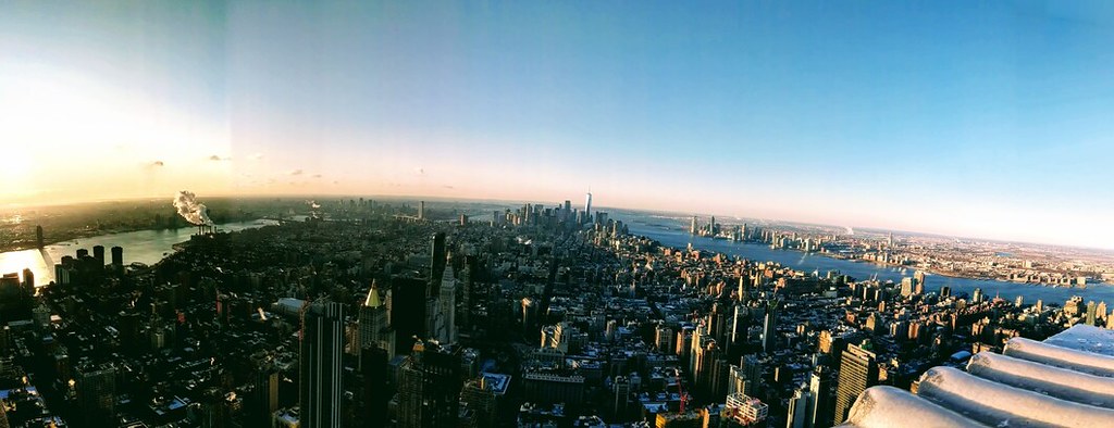
panorama-25 View of manhattan southern tip, from empire state building

Home: is it where I sleep each night, or where I dream of? Spectre of globalism, shadow of the coastal elite - I may be angemeldet in Berlin, but New York will always feel something like home. Inevitably, I’m in the city about once a year, frequent enough to keep up friendships, but infrequent enough to inspire nostalgia for the last visit. It’s a place perpetually in a simultaneous state of metamorphosis and stasis. Gotham, or Girls? Sex and the city Carrie voiceover: “I couldn’t help but wonder, where were all the NYC mappers?”

See full entry

Location: Manhattan Community Board 3, Manhattan, New York County, New York, United States
Posted by smootheFiets on 13 January 2020 in English.

I got myself a cheap “action cam” straight from China, for little more than 20 EUR. GoPros run easily ten times more than that. So, what can you expect from a budget cam? Turns out, it’s surprisingly useful for photo mapping, with a few gotchas.

Can do / can’t do

  • Photo quality, of course, is mediocre at best. You get what you pay for, no more, no less. Videos look useless (I’ll have to try on a bright, sunny day), sound clearly is useless. There’s a lot of good stuff you can do with daylight pics, however.

  • The cam can be mounted on the bike’s handlebar or carried on a neck strap. Both work. Pictures can be taken with gloves on. That’s surprisingly important in January :)

  • Motion blur is an issue. Shooting sideways on the bike, as good as it sounds for shop mapping and such, won’t work. Shooting forward is OK. Night-time shots are for better cameras; this one won’t cut it.

  • Text won’t be readable unless you’re really close-by. Gotta get a feeling for that.

  • Road geometry, lane number, presence/absence of sidewalks, traffic_calming are very easy to recognize. Extremely useful.

  • Cycleway signs (NL:G11, G12a, G13): easy

(this list to be continued)

Geo-tagging

Of course, the camera itself isn’t GPS aware like its more expensive brethren. It does have a clock, though. Not the most accurate one, but still. JOSM can correlate time to GPX tracks. This works.

EXIF

JOSM relies on time information from the EXIF header. Unfortunately, my particular camera model doesn’t create EXIF headers. Time information is recorded in file time stamps, only.

See full entry

2019 saw 760 new mappers in Washington State, again down slightly from previous years. Not a trend we want to see continue. This includes the late influx of Tesla’s mappers that are mapping parking lots so they can summons their Tesla. Don’t think badly of Tesla owners in Washington, it rains a lot. I only wish I could summons my old car.

Welcoming messages were set to 679 new mappers. The message remained the same even though I keep thinking of changing it. Guess there must be something to consistency or is that procrastination?

I was able to identify 7 of those new editors as paid mappers. It was fairly easy since they typically have thousands of edits each. Paid mappers are making significant contributions to OSM. Only Amazon has significant number of edits in Washington. From my experience they are making quality edits. I’ve caught a couple of errors, certainly less that what I’ve made. They are quick to respond and fix the problem.

For the number crunchers here are some of the stats:

  • 760 new users including SEO spammers
  • 679 welcoming messages set with 31 replies (4.6%)
  • 344 users were sent one or more changeset comments (50% of new users)
  • 62 new mappers responded to a changeset comment (18%) It should be noted that not all changeset comments expected a response. For example, if the changeset requested a review and that review was good, a response wouldn’t be required.
  • New mappers contributed over 40K edits since joining OSM. However, paid mappers contributed nearly 32K of those changesets.
  • Not counting paid mappers, new mappers edited a total of 1990 days

See full entry