 OpenStreetMap
Diary Entries in English
Recent diary entries


Putting on my hat as chairman of the board of the OSM Foundation, I have created a wiki page at osm.wiki/OSM_SWOT to collect the OSM community’s thoughts on OSM’s strengths and weaknesses, and opportunities and threats OSM faces. I respectfully ask that OSM community members share their perspectives on that wiki page.
Taking points of the map that are not open or not there anymore.
Hi, I recently suggested to another mapper that we delete all place=localities without a name. osm.org/changeset/79577457
WDYT?
- South Addition Alley paved/unpaved metadata


During the last months, DevSeed data team, as active members of the OSM community in Peru, along the support of other members of the community, imported around 7,933 health centers throughout Peru between health centers of different categories and from different operator institutions both public and private.
Once the importation was completed, about 6,200 new health centers were added to the map, and to those already existing on the map we added more details, such as; operator, telephone, address, category, among others. This was possible by the data found in the Peru’s National Open Data Portal, so, thanks to the open data, we were able to add new health centers to OSM and improve the map in Peru, especially in the rural areas where this type of information was poor and in many other areas they simply did not exist. But currently, after this importation, there are more than 8,600 health centers across Peru, in comparison to the 2,400 that were on the map.
Since returning to the United States from Turkmenistan last June, I have been plowing through the mass of information collected, but which I did not have time to study thoroughly. Yesterday, while (Turkmen-English dictionary in hand) I was deciphering Parliamentary Resolution No. 111-IV of 10 May 2010, I found reference to one of the six towns (‘‘şäherçeler’’ in Turkmen) not yet on the OSM map. That resolution ‘‘inter alia’’ renamed the village around the Danew rail station to Bahar (which means “spring” in Turkmen) and upgraded it to town status. Fortunately user jaimemd had mapped that rail station and its surrounding village five years earlier, so I was able to retag Bahar.
One town down, five more to go. The detective work continues. When done, all current “towns” in Turkmenistan will be on the map, along with all “cities” as defined under Turkmen law.

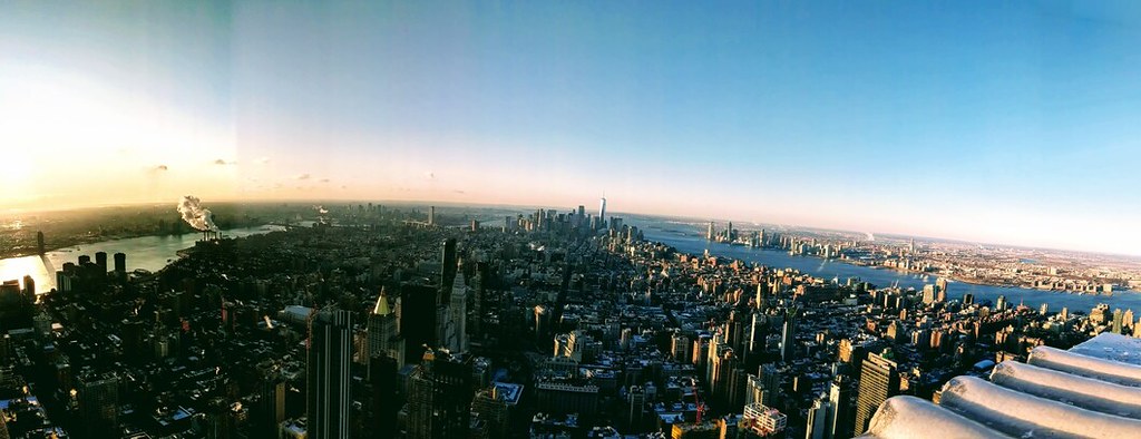 View of manhattan southern tip, from empire state building
Home: is it where I sleep each night, or where I dream of? Spectre of globalism, shadow of the coastal elite - I may be angemeldet in Berlin, but New York will always feel something like home. Inevitably, I’m in the city about once a year, frequent enough to keep up friendships, but infrequent enough to inspire nostalgia for the last visit. It’s a place perpetually in a simultaneous state of metamorphosis and stasis. Gotham, or Girls? Sex and the city Carrie voiceover: “I couldn’t help but wonder, where were all the NYC mappers?”
I got myself a cheap “action cam” straight from China, for little more than 20 EUR. GoPros run easily ten times more than that. So, what can you expect from a budget cam? Turns out, it’s surprisingly useful for photo mapping, with a few gotchas.
Can do / can’t do
-
Photo quality, of course, is mediocre at best. You get what you pay for, no more, no less. Videos look useless (I’ll have to try on a bright, sunny day), sound clearly is useless. There’s a lot of good stuff you can do with daylight pics, however.
-
The cam can be mounted on the bike’s handlebar or carried on a neck strap. Both work. Pictures can be taken with gloves on. That’s surprisingly important in January :)
-
Motion blur is an issue. Shooting sideways on the bike, as good as it sounds for shop mapping and such, won’t work. Shooting forward is OK. Night-time shots are for better cameras; this one won’t cut it.
-
Text won’t be readable unless you’re really close-by. Gotta get a feeling for that.
-
Road geometry, lane number, presence/absence of sidewalks, traffic_calming are very easy to recognize. Extremely useful.
-
Cycleway signs (NL:G11, G12a, G13): easy
(this list to be continued)
Geo-tagging
Of course, the camera itself isn’t GPS aware like its more expensive brethren. It does have a clock, though. Not the most accurate one, but still. JOSM can correlate time to GPX tracks. This works.
EXIF
JOSM relies on time information from the EXIF header. Unfortunately, my particular camera model doesn’t create EXIF headers. Time information is recorded in file time stamps, only.
Small town Michigan that’s located east of Lansing, Michigan.

I see no activity in the IRC
Worked for 1.5 hrs mapping buildings in Abobo, Abidjan, Cote d’Ivoire, Africa. Added new buildings and corrected errors to existing building outlines.

2019 saw 760 new mappers in Washington State, again down slightly from previous years. Not a trend we want to see continue. This includes the late influx of Tesla’s mappers that are mapping parking lots so they can summons their Tesla. Don’t think badly of Tesla owners in Washington, it rains a lot. I only wish I could summons my old car.
Welcoming messages were set to 679 new mappers. The message remained the same even though I keep thinking of changing it. Guess there must be something to consistency or is that procrastination?
I was able to identify 7 of those new editors as paid mappers. It was fairly easy since they typically have thousands of edits each. Paid mappers are making significant contributions to OSM. Only Amazon has significant number of edits in Washington. From my experience they are making quality edits. I’ve caught a couple of errors, certainly less that what I’ve made. They are quick to respond and fix the problem.
For the number crunchers here are some of the stats:
- 760 new users including SEO spammers
- 679 welcoming messages set with 31 replies (4.6%)
- 344 users were sent one or more changeset comments (50% of new users)
- 62 new mappers responded to a changeset comment (18%) It should be noted that not all changeset comments expected a response. For example, if the changeset requested a review and that review was good, a response wouldn’t be required.
- New mappers contributed over 40K edits since joining OSM. However, paid mappers contributed nearly 32K of those changesets.
- Not counting paid mappers, new mappers edited a total of 1990 days
small trails
ethnic restaurants
American restaurants
chain restaurants
parking lots
snowmachine trails (nancy lake region)
buildings
state and city offices
This is the script I came up with to make some stats on the huts and shelters of Sweden. The data was fetched via overpass-turbo.
download the geojson from Overpass Turbo -> export or save as from JOSM.
example query: access!=private and (tourism=alpine_hut or tourism=wilderness_hut or (amenity=shelter and shelter_type!=public_transport)) in sweden
you can run this query from inside JOSM - see the JOSM wiki.
The script is here: https://gist.github.com/pangoSE/5294e835c9bead773e8036603a90b898
This was the output for Sweden:
$ ./stats.sh vin-190110.geojson
Numbers of each type:
Shelters - total: 2629
Shelters - Lean to (sv. vindskydd): 793
Shelters - Basic hut (sv. stuga utan uppvärmning): 129
Shelters - Weather shelter (sv. väderskydd endast lämpad för kort uppehåll vid dåligt väder): 355
Shelters - Picnic shelter (sv. liten byggnad med tak, eldstad och skorsten i mitten): 251
Shelters - Unknown type: 1692
Wilderness huts: 43
Alpine huts: 82

Lean_to shelters details:
- has description tag: 29 - 3%
- has fireplace=yes: 305 - 38%
- has floor=wood: 7 - 0%
- has image: 18 - 2%
- has snowmobile=yes: 28 - 3%
- has water_source tag: 4 - 0%
- has wood_provided=yes: 3 - 0%

Basic huts details:
- has description tag: 16 - 12%
- has fireplace=yes: 52 - 40%
- has image: 1 - 0%
- has snowmobile=yes: 18 - 13%
- has water_source tag: 0 - 0%
- has wood_provided=yes: 0 - 0%

Wilderness huts details:
- has description tag: 18 - 41%
- has fireplace=yes: 41 - 95%
- has image: 5 - 11%
- has snowmobile=yes: 18 - 41%
- has water_source tag: 0 - 0%
- has wood_provided=yes: 0 - 0%

Alpine huts details:
- has description tag: 12 - 14%
- has fireplace=yes: 4 - 4%
- has image: 5 - 6%
- has snowmobile=yes: 19 - 23%
- has water_source tag: 2 - 2%
- has wood_provided=yes: 5 - 6%

Earlier this year, Facebook launched their new AI detected feature service MapWithAI along with their custom version of the iD editor, RapiD. Kaart quickly adopted RapiD into our road vectorization workflows and saw impressive efficiency and data accuracy increases for those projects by being able to focus on the quality of the edits with the time usually spent on vectorization. We recognized the potential impact on data coverage and editing efficiency but noticed a need for an integration with JOSM.
It’s a known problem that web based editors like RapiD are difficult to use where an internet connection is either unstable or is slow enough that it brings the editor to a halt. Incorporating the MapWithAI data into JOSM would facilitate use of the data in parts of the world where a network connection may be unstable.
In September, one of Kaart’s engineers, Taylor Smock, started working on a project to create a JOSM plugin that would utilize the MapWithAI service. With some technical support from the Maps team at Facebook, we have been able to create a plugin at feature parity with RapiD but with some JOSM-esque additions.
For those who aren’t aware, inside some OSM editors is something called the “Name Suggestion Index” or NSI, and this lets mappers use a consistent name / brand across the map, for places such as a McDonald’s, or a Supermarket.
Many people may have used the NSI (https://nsi.guide) without even realising it - if you added a node or way and started to type, for example “Burger King”, and had the editor suggest to you that you select “Burger King” with the official logo on screen, this was the NSI at work.
The NSI is maintained over on GitHub, and suggestible names don’t all exist on the list automatically, they have to be added to the index.
One such suggestion I have made to the group of maintainers is adding brand names for Supermarket Cafe’s within the UK, including Tesco, Asda, Sainsbury’s, M&S and Morrisons, as I believe many of the supermarkets include a cafe inside, and having them mapped as a node (amenity:cafe) within each store would be beneficial to OSM and OSM users. All these supermarkets have a separate NSI entry for their respective petrol stations, and I think the same should be true for their cafe’s
Not all stores have a cafe, and of those that do, not all of them follow the same opening hours as the main store, which is another reason I think adding them separately would be beneficial.
One question that has arisen is if this is a suitable addition to the NSI, and if the name tag should be that of the Supermarkets name, eg “Asda Cafe”, or if it should be something else, as the cafe itself is inside the Supermarket, and often physical signage within the store simply reads “cafe”, which, while might be the correct “name” to give, could be considered too generic, and actually flags an error within iD.
I’d be keen to hear anyone else’s views on whether Supermarket Cafe’s should exist individually within OSM, and if so, should they have the name that matches the supermarket itself, eg “Asda Cafe”, or be left blank, or as something else?

The Land of Hills and Ponds
As I mapped Turkmenistan a couple of years ago, I noted that two locations were marked as the town of Darganata. Only one could be correct, and in my explorations I determined which one was Darganata, then pursued the correct name of the other, which turned out to be a village named Çarwadar. I made the correction, but filed away a question in the back of my mind: why would a mapper insert such an obvious error in OSM?
The answer came to light yesterday as I examined a Soviet military map of the area. In Soviet times, Çarwadar was a state farm named Sovkhoz Dargan-Ata, or in Russian совхоз “Дарган-Ата”(the contraction “sovkhoz” means “state farm”). Not a town, not even a village in Soviet terms, but a state farm community named in honor of its big brother a few kilometers away. Mystery solved! Today Çarwadar is a full fledged village, not just a farm community, and enjoys its own name, which means “herdsman”. The old state farm focused on sheep raising, and presumably the residents of Çarwadar still do.