 OpenStreetMap

Im edit in file 901 edit so in happy in this work
Diary Entries in English
Recent diary entries
Posted by amapanda ᚛ᚐᚋᚐᚅᚇᚐ᚜ 🏳️⚧️ on 2 September 2019 in English.

I have made some LGBTQ/rainbow pride versions of the OSM Logo:
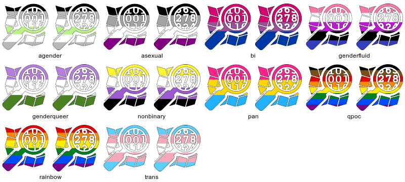 What I’ve done is CC BY-SA 4.0, but the OSMF Trademark Policy probably means that doesn’t apply. view all here
I have it all in a github repository, please feel free to download, share, remix, make suggestions, print yourself, etc.
I plan to print some of the these out as 5.2cm× 5.2cm stickers and bring them to State of the Map in Heidelberg. Would you like some? Would you like a specific one? I was only going to print one or two designs. Leave a comment here, or OSM message me, or email me to request a specific set, and how many.
My Editing 858

I’m primarily working on surveying Electric Vehicle charging stations to power https://gitlab.com/showmethechargers – I have got everything in the Kirkland Lake + New Liskeard area, everything near the highway through North Bay, and I’m about 6 away from getting all of Kitchener + Waterloo, which I will hopefully get soon.
I’ve planned a trip to survey Stratford. After that Cambridge will probably come in bits and pieces over time as I’m not there much.
My other main survey focuses (usually in areas I’m surveying anyway, or sometimes just while passing through) are: bicycle parking, mailboxes, and business opening hours.
My main tool of choice for survey right now is to take photos of any useful object or detail with my phone, with compass and location tagging turned on. This gives me a close (but not exact) geopoint which I can correct using memory + satellite imagery later when inputting with iD.
I would really like to fix the transit map for Kitchener/Waterloo (since it’s out of date after the new launch) but that’s not really doable in iD and I haven’t sat down to learn JOSM yet. I’m also not sure how much of that I can claim is from “local knowledge” without being poisoned by seeing the official maps and timetables. Ideally we could just use the Region’s Open Data but not sure on license compatibility.

Today I would like to share what I have learned about using external data in OSM but not in the classic import fashion.
I have gone over what I have learned about data importing in OSM after being involved in a few of them. But today I want to talk about how we’re using data from our local government as a reference but not using the usual import method and why.
So what is the definition of an import in regards to OSM? The Wiki defines it as “the process of uploading external data to OSM.“.
But uploading is not always the most effective way to use external data to improve OSM. What we are doing is showing external data as a layer over OSM and using that to edit OSM by hand.
But Why?..Wouldn’t it be better to direct upload the data?
Posted by Monica May on 31 August 2019 in English.
Last updated on 1 September 2019.


This post is an answer to Roland’s call for input on his planned SotM session on New processes to agree on tagging suggestions and their interaction with the editing software available on openstreetmap.org
I have no specific suggestion for an overall solution to the problem but a few observations on the matter that i would like to share on the level of problem analysis so to speak.

The last post introduced Wikidata, and covered how to extract basic information from wikidata dumps using a postgres database and regular SQL queries. This post explains some simple SPARQL queries and the Wikidata Query System and related API, and how they relate to the improvements desired in Nominatim. The following examples, along with a few other tools from the Wikidata ecosystem, are a good start for any OSM contributor that is Wikidata-curious. 
Explaining SPARQL
For a new user, probably the most foreign aspect of using Wikidata is the need to know something about SPARQL. So what is SPARQL?, and why do you need it?

August 29, 2019. Just registered and looking forward to starting with OpenStreetMap! Orientation meeting at my firm next week.

I added some road names and place names today in Beitbridge

Dear all,
Today, v4.22.0 of the OpenStreetMap Carto stylesheet (the default stylesheet on the OSM website) has been released. Once changes are deployed on the openstreetmap.org it will take couple of days before all tiles show the new rendering.
Changes include
-
Shop label fixes and use ST_PointOnSurface for building label placement
This fixes some bugs and makes building label placement consistent with shop label placement.
-
Use
cache-feature: trueto improve performance of layers with attachments -
Use retail colour fill on malls
-
Drop
highway=stepsfrom zoom 13This makes step rendering consistent with footways
-
Render
place=localityfrom zoom 16This fits current usage of the tag and what it is normally tagged on.
-
Render
natural=bayfrom linear ways -
Render administrative boundary labels from relations only
-
Stop rendering natural=marsh
It is recommended marshes are tagged with
natural=wetland+wetland=marsh -
Use a whitelist for barrier rendering, and render
historic=citywallslikebarrier=city_wall. -
Support new Tibetan font name
Noto has renamed Noto Sans Tibetan to Noto Serif Tibetan. The old name is still supported.
-
Code cleanups to increase reuse and improve consistency
Thanks to all the contributors for this release, including daveol and btwhite92, new contributors, and jeisenbe, a new maintainer.
For a full list of commits, see https://github.com/gravitystorm/openstreetmap-carto/compare/v4.21.0…v4.22.0
As always, we welcome any bug reports at https://github.com/gravitystorm/openstreetmap-carto/issues

A year I was just starting as a volunteer for the CWTS++ program, from answering a question to being accepted in the program. I did not even realize that there is something beyond this before I thought the benefit of it was just the technical of mapping. Surprisingly, I did not even expect what would be coming as I went through with it and imagine representing it to other people.
So I am one of those people that got lucky and been awarded a travel grant to “Pista ng Mapa” a national conference in Dumaguete, Negros. So everything is sponsored and I am thankful for that because I get to experience something new again, this includes air travel and no parental supervision outside of Manila.
One of the workshops that I went to is Data Storytelling with Open Contracting Data. I just had a feeling that’s why I choose this workshop and I can’t to the other workshop ‘cause I already have experience in OpenStreetMap and it was only the introduction of it. So I challenge myself by force and went to the Data Storytelling, even though I don’t have a clear idea of the whole workshop rather than creating a story with the given data. The speakers were journalists and data scientists which amused me about their topic and the talk itself, even though I can’t intake everything they’re talking about. I was grouped with other people which had a lot of experienced specially with politics, academe, and volunteering. They taught me how to filter a whole of data set which was around a thousand plus items, you have to sort it, tally it, analyze and make an interpretation out of all the gathered data to create your own story. Sadly the time was not enough to create the whole data story but it was fun learning at a different level.

I experimented with extracting the heights values from the drone imagery and add them to the building polygons traced in OpenStreetMap. Read along if you want to understand the process or just go here to see it in action here!
 3D buildings around Foundation University, Dumaguete
Day 3 of Pista ng Mapa last Aug 3, 2019 was a series of field mapping activities. A couple of people did on the ground survey with field papers and mapillary. Our resident drone Mapher Leigh deployed her DJI Phantom 4 to survey the event venue and its surrounding community. Leigh uploaded all the drone derived data into OpenAerialMap including the elevation models! Using QGIS 3.6, I decided to explore ways to extract the heights from the derived DSM/DTM and use it for visualizing building polygons from OpenSteetMap.
For this exploration I used QGIS 3.6 with the GRASS GIS, Profile tool and QGIS2threejs plugin.
Downloading the drone derived layers from OpenAerialMap
Posted by JasonManoloudis on 26 August 2019 in English.
Last updated on 13 November 2019.
Introduction
So, this is the final entry of a what has come to be a 6 entries series, regarding this year’s Google Summer of Code project and the work that has been done on the 3D Renderer OSM2World. This post will summarize the last 2 tasks that did not get their own separate entries as well as give an overview of the whole summer work, starting from the latest. The two tasks in question are those of Rendering Destination Signs and Guessing the positions of non-explicitly defined signs, as stated in the application document, which have proved to be particularly challenging to say the least; we will go through them later on this post.
So without further ado, let’s present what has been done so far in this Summer of Code, in a chronological order:
- Font rendering for signs with custom text: https://github.com/tordanik/OSM2World/pull/147
- Human readable traffic sign values: This particular task does not have a pull request of its own as its TODOs, mentioned in the application document, where gradually being implemented as parts of the other tasks (a good example of this can be found in this entry)
- SVG texture support: https://github.com/tordanik/OSM2World/pull/151
- Traffic sign catalogues: https://github.com/tordanik/OSM2World/pull/153
- Destination signs: https://github.com/tordanik/OSM2World/pull/154
- Guessing the positions of non-explicitly defined signs: https://github.com/tordanik/OSM2World/pull/155 (may be changed)
A summary is available for each of the first 4 tasks, in their corresponding diary entries, listed below in the same order:
- Font rendering for signs with custom text
- Human Readable traffic sign values
- SVG texture support
- Traffic sign catalogues
Let’s now see what the remaining 2 tasks are all about!
Rendering of Destination signs

I’m working on repairing the forest multipolygon in Hokkaido. They are deleted/modified/destroyed badly for several weeks ago.
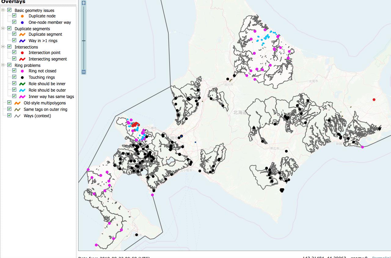
It is very hard to repair with revert or redrawing, because the damage is too serious and complex. So I would like to reuse the polygons from old planet files if possible.
But I’m facing versioning issues. Anyone has more easy solution?
- Extract multipolygon relation using
osmium: Like those command.
osmium getid -r ./hokkaido-190601.osm.pbf r1083877 -o r1083877.osm
- Merge: Merging those polygon and current osm.org data using JOSM
merge selection. - Upload: It causes numerous conflicts due to object version is smaller than https://www.openstreetmap.org’s current objects.
Should I tweak the xml file for versioning? (e.g. using sed or some other methods)
P.S. The vandal mapper is editing his edit ignoring my message/changeset comments. I already reported this with https://www.openstreetmap.org’s reporting feature.
The changeset #72729838 is primarily based on my survey of June 29, 2019, on foot. I also referred to my GPS tracks captured on May 11 and February 16.
Satellite Imagery Offset
- Bing (2019): -0.16; 1.55
Notes
- The road of way 139699909 needs to be confirmed. I guess it doesn’t exist as it looks a private property.
- I reversed the positions of some nodes (2744001342, 2744001328, and 2744001278) on Kumagaya-Gyoda city border (way 269108227) as it looks some mappers mistakenly dragged them with other map objects.
Posted by Carlos Brys on 25 August 2019 in English.

On May 24, 2019, the Ministry of Public Works and Communications (MOPC) of the Republic of Paraguay published Resolution No. 1090/19, which “Categorizes and Classifies National Routes”, whose last update was made in the year 1,962.
Within the framework of Law No. 5552/2016, 10 new national routes were created and the routes of historical routes were redefined as national routes No. 2 and No. 7, as well as the criteria for references as PYnn .
This decision led to the organization of a task with the OpenStreetMap Community of Paraguay, and on the OSM-Py Telegram channel the criteria for the designation and classification of existing roads that became part of the road network were discussed and agreed upon of national routes.
Based on the maps published by the MOPC (https://www.mopc.gov.py/mopcweb/index.php/download_file/view_inline/3198), during the months of July and August 2019, members of the communities of OSM Paraguay and OSM Argentina, intervened the map by editing and re-labeling the existing ways to adapt it to Resolution No. 1090/19.
Thanks to the work and dedication of a group of committed users, after an arduous task, the map of the Republic of Paraguay is displayed in OSM as established by the Law and the relevant Resolution.
“In the Eastern Region of the country, 3,494 km of national routes now have 5,502 km of paved routes, while the Paraguayan Chaco adds 4 more routes to its road heritage, totaling 3,554 km, which bet on the development of the entire Western Region. ”(https://www.mopc.gov.py/mopcweb/index.php/actualizacion-de-la-red-vial-de-rutas-nacionales-del-paraguay)
The new map of national routes of Paraguay can be seen here: http://u.osmfr.org/m/356487/ and the descriptive information, as well as all the relations are in the OSM wiki: osm.wiki/ES:Paraguay#.28Mapa_de_Reclasificaci.C3.B3n_2019.29
The changeset #72213609 is based on my survey of June 29, 2019, on foot.


Avoid the crowds and tripadvisor, a vacation is only an adventure if you find the escape velocity of your known universe and reach it, and you’ll find outside that, another version of yourself that just might follow you home.
We had seen the soaring ceilings of the Hagia Sofia, I was already used to the chingchonglinglongs from shopkeepers in the Grand Bazaar, we went to the Blue Mosque on a day it was closed to non-believers, we’d eaten homemade sigarabörek by her aunt for dinner, we’d taken the ferry to the tip of the Asian continent… It was day 3 of Istanbul, and my best friend had a family engagement that night. I wasn’t brave enough to venture back to the Asian side to visit a nightclub on my own, and had been advised against going out by myself anyway.
What else do you do in a big, unknown city on a Friday night?