 OpenStreetMap

Mapathon Training for Vulnerable communities coordinated by Mapathon coordinator Nigeria. University of Nigeria, Enugu Campus.
Diary Entries in English
Recent diary entries
Posted by JasonManoloudis on 1 August 2019 in English.

Introduction
The completion of the Traffic sign catalogues task brings a long-desirable feature in OSM2World: being able to define and configure materials solely through the configuration file, without the need for them to exist in Materials.java!
During this main feature’s implementation, the Human Readable Traffic sign Values task also came to a more complete state by adding lines of code related to it, while progressing, to cover needs that came up.
This entry will be split into 3 parts, separately covering Human Readable (H-R) values-related additions to avoid possible confusion. It is worth mentioning that there are of course more changes than the ones explained here but as changes are being constantly made it would be practically impossible to include every detail that has changed since the last diary entry. Plus, it would turn out to be boring for the readers.
That being said, sample sign images with the material definitions/configurations that create them included can be found by the end of this entry!
Let’s get started:
Human-Readable values related additions
I will try to keep things short and briefly present only the most important points as this is not the main focus of this entry:
- A clear distinction between H-R values and non H-R values is now taking place in TrafficSignModule.java. Its simple implementation may seem obvious at first but it had to be validated by looking through a lot of Overpass data with a query like
[out:csv(traffic_sign;false)];
nwr[“traffic_sign”][traffic_sign~”:”]({{bbox}});
out;
that looks for traffic sign values that include “ : “ in their name i.e. are country prefix - sign ID pairs like DE:267 . Using that, one can see that there were no cases where a sign contained both a country-prefixed value and a human-readable one together (e.g. v=’DE:254, maxheight’ ) so the code below was deemed to be the way to go:
HI DIARY,
This is our first entry. Actually, this is a joint account of me and Angelica. We are here at Foundation’s University attending the first ever Pista Ng Mapa. We’ve got a little problem, we are not officially signed up for this and we don’t know if we’re going to learn anything today. We are just here to eat. Hays.
Just kidding!
Yours truly, Raya

I updated the “Long Names Of OpenStreetMap”.
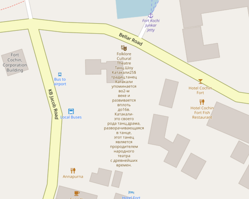
Now there are 722 long names, that is, objects with a name longer than 150 bytes.
I haven’t run a full update since October 2017. Back then there were 464 long names. So I guess we’re getting worse at keeping our names short.
It looks like bus routes with very long name values are becoming more widespread. For example here is the “391 “B”: Veresegyház, Misszió Egészségügyi Központ => Veresegyház, Dukát utca => Veresegyház, Cserje utca => Veresegyház, Eötvös utca => Veresegyház, Újiskola utca” bus route. Snappy name!
Maybe I should’ve limited by character count rather than bytes. Cyrillic scripts are at a unicodey disadvantage, not to mention chinese.
Not all of them cause wacky rendering like the theatre example in the screenshot above (node).
I do think they all have something in common though. Using the name tag for something which isn’t really a name.
Organized a training for youth mappers team Abia State University, Uturu (ABSU Mappers team). It was training to prepare local mappers for the an upcoming Mapathon for communities in Nigeria vulnerable to flood.
Had over 40 Local/Youth mappers in attendance.

The last post explained some of the background on the use of Wikipedia page links and other information in Nominatim. This post covers looking into Wikidata as another source of information that may be of use.  Wikidata is the knowledgebase of the Wikimedia foundation. It was founded in 2012 with the goal of collecting factual data used in Wikipedia across all languages. The project is maintained by over 20,000 active community contributors.
The Wikidata repository consists mainly of items, each one having a label, a description, and any number of aliases. Items are uniquely identified by a Q followed by a number, such as:
Statements describe detailed characteristics of an Item and consist of a property and a value. Properties in Wikidata have a P followed by a number, such as:
Properties can point to values, such as:
Or properties can point to values that represent other concepts, such as:

Please use this space to contribute feedback on the proposed path tagging schema.

If buildings are to be placed on a smaller scale maps, they must be prepared: simplified, then typified and finally aggregated/amalgamated.
Building simplification is not the same as line/polygon simplification (done with DP or VW algorithms). When simplifying building, you want characteristic details to remain: for example most buildings have square shapes, that must remain in simplified version.
Example of building simplification:

Here dashed polygon - original building, yellow one - simplified to specified amount.
As you can see square angles have been preserved as well as larger details while smaller details have been removed.
Thank God am now a member of unique mappers
I’ve been very stupid lol sorry for the mistakes I was just testing

Wijzigingenset: 72604895 #hotosm-project-5652, #TanzaniaDevelopmentTrust Same District missing buildings 4 days ago geleden gesloten door Alessandro Steinhart| Message send. Follow medio august 2019
New proposal for categorising paths: osm.wiki/Proposed_features/path_defined_by
I previously wrote about the challenges of categorising paths - and created a (failed) proposal for a tagging scheme.
As is the way with Openstreetmap the proposal I wrote then failed to catch anyone’s excitement/interest. But the mapping of paths continues to pose real issues. So I recently wrote another proposal - this time to try to define paths according to how they have arisen - whether they are constructed or simply worn lines on the ground, and whether they are defined by markers or arise perhaps from wear by animals (but are also used by people).
As I’ve said in the proposal: >”Paths vary hugely in character - but current mapping struggles to capture the differences. There have been various attempts to agree a simple method to categorise or rank paths and path status. … What people call a ‘path’ varies hugely. In theory it might be best to record path attributes and to categorise paths according to this data, but in practice this is entirely unrealisitic (at least in the short term). To classify a path adequately it is necessary to take into account at least path width, incline, tilt, variation in tilt/incline, degree of camber, edge quality and character, surface material, surface material grade, surface compactness, surface slipperyness, smoothness, and visibility. Partly issues also arise because paths are used by people with such different needs - whether for example on foot, in small motorised vehicles, on one of many very different bicycle designs, in one of many wheelchair designs, or pushing many different forms of wheeled equipment. This means that it becomes almost impossible to agree on simple definitions of some important characteristics (such as ‘smoothness’).”
I’d welcome comments - the proposal is here osm.wiki/Proposed_features/path_defined_by

tl;dr the release notes 📗
The latest version of MapRoulette, 3.3.3, was released today on maproulette.org. There have been a few notable new features and updates since I last wrote about MapRoulette in the 3.3 release post, so here’s a new diary entry to talk about what has happened since in MapRoulette land!
Virtual Projects
Challenges are organized in Projects. A Project lets you, or your organization, organize Challenges that belong together. You can create as many projects as you like, and move Challenges between them if you want. Each Project’s page lets you review progress metrics and comments for all challenges in a project, combined. This is pretty handy, but also a bit limited. That’s why we added Virtual Projects. Virtual Projects are different in a few ways:
- You can add any Challenge to a Virtual Project, not just your own.
- Challenges can belong to more than one Virtual Project.
Just like regular Project pages, your Virtual Project’s page has progress metrics and comments related to all challenges that are currently in your Virtual Project. You create a Virtual Project just like you would a regular Project.
Improved Mapillary integration
We introduced a Mapillary overlay in version 3.1.1, but it was not so great to use yet. We have improved it a lot, it now shows Mapillary image locations that are more relevant to the task location, and we use the native Mapillary viewer widgets, so you can zoom in and easily skip to the next or previous images in a Mapillary sequence.
I shot and added as an experiment the aerial sphere 360 panorama to the OpenStreetMap for the lake Lac de Tseuzier: https://www.openstreetmap.org/relation/1642268
The sphere panorama itself is located on the DJI’s website: https://www.skypixel.com/photo360s/spark-78d50747-504a-4a84-90c9-6a02357eb70e .
Here is the link to the same panorama on Google maps: https://goo.gl/maps/GZjbKr1J7hy3WgYU7 , and in the Street-View mode it is shown on the map as a small blue circle.
The area of this lake is about one square kilometer. The size of the panorama file is 1.8 MB. It is created with the Spark quad-copter, which weighs less that 500 grams. Spark creates and publishes the aerial sphere 360 panoramas to the Skypixel website automatically from the DJI Go 4 app.
I added it with the “image” tag. In my opinion, it is time to introduce a new OSM tag for the aerial sphere panoramas.

This is my first pin to easily locate my research area in Pune.

Dear OSM Community,
At Amazon we are coming across a situation where unmaintained track roads have no access tags. We would like to know your suggestions/feedback on how to tag these roads.
Track Roads:
By definition track roads implies traversal of motor vehicles and are mostly used for agricultural use. We have private GPS traces showing where delivery vehicles go, and when we match them against OSM data, we see they’re going along highway=track ways. We want to add appropriate access tags so that routers can route correctly along the data in the future.

The driver trace is on-the-ground evidence that the road can be used by motor vehicles for deliveries, but we have no evidence either way that the road can be used for general traffic.
There are four different ways we’ve come up to tag this information:
1. motor_vehicle = yes
Date: 22/07/2019
Today I mapped a village near the town of T’boli in Indonesia. I have made 63 changes in total. This includes adding a tributary and a confluence to the Allah river. I also mapped out several building and a few residential roads too.
We discussed and planned for the forthcoming mapathon challenge and the training for local youth mappers #ABSUMappersTeam #OSMNigeria
Had the first Validation training on the use of JOSM to validate edits. Emphasis was on the need to maintain standard, ensure accuracy and meet the need of the user. Timeliness of validators inputs was reemphasized and the need to encourage local mappers while correcting and advising them on the best mapping practice

So, I’ve not really gotten into Open Street Maps, but figured that I might delve into it a bit, as I’m not liking Google as much these days. - I use an Android phone, so any hints or tips would be welcomed. - I can be found on Mastodon as @randynose@fosstodon.org or on Twitter (not checked as often) as @RandyNose.
Randy 07-21-19