Diary Entries in English

Recent diary entries

Dear all,

Today, v4.21.0 of the OpenStreetMap Carto stylesheet (the default stylesheet on the OSM website) has been released. Once changes are deployed on the openstreetmap.org it will take couple of days before all tiles show the new rendering.

Changes include - Removed unused world_boundaries-spherical.tgz file from scripts

  • Switch to osmdata.openstreetmap.de for water & icesheet shapefiles

  • Started using ST_PointOnSurface for some label placements

  • Adjusted index for military areas

  • Adjusted starting zooms for labeling of administrative areas.

  • Revert rendering of healthcare key

  • Stop place some place labels when the objects become too big or at high zooms.

  • Only render capes as points and render them like other points.

  • Only render ferry lines from ways, not relations

  • Improved developer internal documentation

Thanks to all the contributors for this release including Nakaner, a new contributor.

For a full list of commits, see https://github.com/gravitystorm/openstreetmap-carto/compare/v4.20.0…v4.21.0

As always, we welcome any bug reports at https://github.com/gravitystorm/openstreetmap-carto/issues

Posted by gecho111 on 2 May 2019 in English.

I’ve been re-riding my city by bicycle this year. My goal was to visit more of the roads I typically ignore. My progress has been much faster than I expected due to extended cold weather keeping me in the city instead of riding out on the highway.

JOSM is great at displaying multiple GPS traces at once. I even managed to load up all 1,400 of mine though it took some time.

I saved a local copy of the road network in an .osm file and have been crossing off roads in JOSM as I visit them. I’ve come across a few unmapped roads and paths on my journeys while doing this. The first time I rode the city back in 2014 I found hundreds of unmapped service roads.

Using the pruned road network file I use mkgmap to create a map overlay for my Garmin that shows me roads I haven’t covered yet this year which I update after each ride. I also have a second overlay that shows me roads I’ve never been down of which there are about 25 km, mostly high speed roads with no shoulder.

See full entry

Location: Regina, Saskatchewan, Canada

So as you know from my first two posts I have Microsoft building foot prints and county address data, two good sources of data. Both worth a import on there own. However we want to make the most efficient use of our mapping time so Mike came up with a way to conflate the data sources. And save a lot of time! Importing data into OSM has a good bit of overhead (still worth it). As I’ve talked about before you have to go get the data, figure out how to process the data with a procedure for Tracking, coordinating, and QA. Then once you figured out all of that you have to have local community buy in and go through the mailing list where your proposal will be vetted in a public way. So where it makes sense, it is worth thinking about using your available data sources in conjunction with each other to minimize going through that over and over. Now it does come with some additional risk, your proposal will face more scrutiny the more complex it is. And simpler single imports might lend them self’s to more mappers helping you with it. That’s a judgment call you will have to make. Im going to stay fairly high level in this post if you want to know the nuts and bolts of everything there is great documentation that Mike wrote on the GitHub https://github.com/OpenStreetMapSC/MergeAddressesAndBuildings and osm.wiki/Spartanburg_County_Address_And_Building_Import

See full entry

Posted by itsamap! on 1 May 2019 in English.

Ok! I’m on board, let’s use some data for OSM!! Wooo Yeah!!! Where’s the data?…

I spent a little over a year trying to get access to data, once I decided that was what I wanted to do. I now have permission from the local county where I live, some other county’s and some state data. And WoW! We now have more data to work with than we have time and mappers to processes it. It’s a good problem to have. So how did this happen?

This was my struggle and why it was worth it.

See full entry

Posted by itsamap! on 1 May 2019 in English. Last updated on 2 May 2019.

In this blog I will talk about what data we are using, how we are processing the data, then importing it into OSM. Some things are not considered imports at all since they’re more of a stare and compare, but I will cover them as well since we are using data others collected and have made available to us for use in OSM. Even analyzing data that is already in OSM to improve data quality. All that and more! :-)

First off, I understand many people do not like using others’ data for OSM for a couple of different reasons.

  1. The data could be low quality. I once talked to a mapper when I saw that they removed an imported move theater from the middle of a corn field, due to someone blind importing. …Ouch!

  2. Imports require a lot of technical knowledge of OSM and that excludes a lot of mappers.

  3. Making sure the data is not copyrighted in a way that prevents it from being used in OSM. (I’ll touch on that in another post) There might be more, but these are the ones that I have heard so far.

In this blog I hope to address these concerns by demonstrating how we can set things up in a community-oriented way that streamlines the process and also keeps quality high. We have so many tools to at our disposal that I keep stumbling across them and finding new ways to use them for different projects! I hope to gain working knowledge and demonstrate how they can all work.

Also, I will be talking about how I got access to data for our local area and tips on how you might be able to do the same. That can be half the battle!

See full entry

Over the last couple of years, the Cullowhee valley region has changed drastically. The university is growing and expanding and changing each year. Within the next 2-3 years, two of the older dormitories on campus will be going offline in preparation for new residence halls. Hopefully, if they are completed while I am still attending the university, I plan to outline a lot of the details of the additions. If anyone is familiar with the area, I plan to start cataloging in the very near future fire hydrants, FDC’s, and water points all across the valley for local emergency personnel to hopefully view the data we collect.

Does anyone have any groups forming in the area for OSM? Or perhaps, does anyone have any advise in how to efficiently collect and record this data to put into OSM?

Thanks, Ivan

After a lot of breaks in between and a few months, I’ve finally finished mapping Emerson! It took quite some time, but it’s finally done. At first, I was working pretty slow, but I started making more progress towards the end of April.

Something I found pretty interesting about Emerson is the small amount of businesses there. I might go add names to all the businesses in Emerson because there’s such a small amount of them.

Anyway, the next place I’ll map is Teaneck. It’s quite large in area compared to many other places in Bergen County, and has the second highest population.

Click below to see Emerson!

Location: 40,978, -74,028
Posted by Sam Wilson on 1 May 2019 in English.

Gosh, the spammers are going for it at the moment on the OSM diaries. :-(

Thank you to everyone who’s handling the deleting of it!

Unfortunately, my feed reader sucks all the bogus entries in before they’re deleted, so I’ve got hundreds of Chinese spam posts (marked as Bengali for some reason), drowning out the interesting stuff. I’d switch to just the English feed, but am getting things via https://blogs.openstreetmap.org/atom.xml so there’s no option for that, and I don’t want to miss the other syndicated blog posts.

Maybe I should just head outside with a GPS… :-)

Posted by PeanutButterRemedy on 30 April 2019 in English. Last updated on 1 May 2019.

Background

There exists at least one company out there that sells a service of boosting client company’s ranking in Google search results. One of the tactics they employ to accomplish this is putting the company name and website in as many places as they can. One of those places is a node on OpenStreetMap. It should be pointed out that there is nothing inherently wrong about adding this information to OSM. In fact, it is encouraged. However, the methods by which this particular company accomplishes this go against many of the best practices and guidelines that the community has set forth. This has caused much frustration in the community having to chase down their edits and correct them. Many attempts have been made to contact this company to work with them to correct their behavior, but they have all fallen on deaf ears.

Bad Behavior

Some of the actions the SEO has engaged in include the following:

  • Creating throw-away OSM accounts for every single edit they make
  • Registering accounts with email addresses that are ignored
  • Using email addresses that purposefully hide the organization that created the accounts
  • Spoofing or masking their IP addresses

These are all tactics they are using to avoid user and IP level blocks so that they can continue to pump bad data into OSM without being blocked.

Bad Data

A sampling of their additions shows the following type of problems:

  • Street addresses that are abbreviated (Rd vs. Road, St vs. Street)
  • Unit/Suite information improperly added to addr:street
  • Freeform text in the opening_hours tag
  • Upper case characters in key names (Telephone vs. phone)
  • Made up tags instead of proper feature tags (category=Southwest Furniture vs. shop=furniture)
  • Lazy errors (amenity=place_of_worship for a fish restaurant)

See full entry

Posted by mvexel on 30 April 2019 in English.

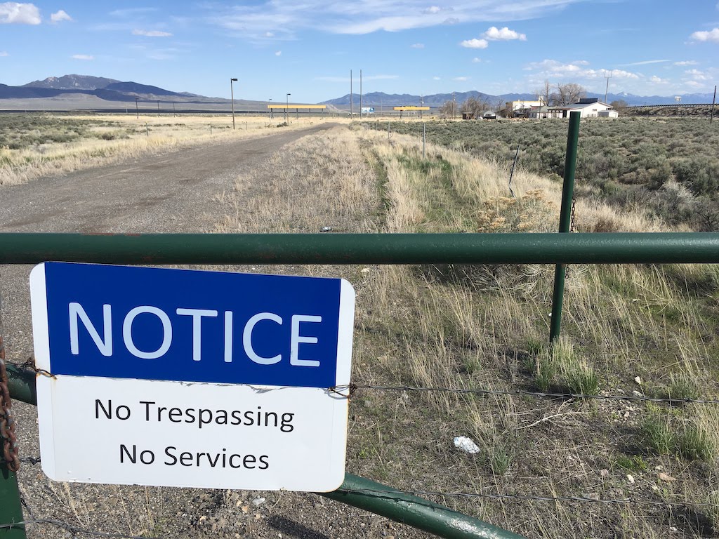
A hamlet in OpenStreetMap is, according to the wiki, “A smaller rural community, typically with fewer than 100-200 inhabitants, and little infrastructure.”. It is smaller than a village but larger than an isolated_dwelling. So, basically, it’s a very small rural town.

Oasis, Nevada. A hamlet in OSM.

According to OpenStreetMap, there are around 750 hamlets in Utah. I know we have a lot of small rural towns but I am not buying that it’s that many. Let’s have a look.

It turns out that all but 20 of the Utah ‘hamlets’ are the result of a poorly documented 2008 import of GNIS points. (There may be more changesets related to this import.) 500 of them have not been touched at all by human mappers since then.

See full entry

I am Ezugwu, Victor Chukwuma. victorchukwumaezugwu@gmail.com,

https://mobile.facebook.com/victorchukwumaezugwu?ref_component=mbasic_home_header&ref_page=%2Fwap%2Fhome.php&refid=8

I am a Nigerian and graduate of the University of Nigeria Nsukka where I read Geoinformatics and Surveying. The pioneer team leader Lionmappersteam Enugu Campus of the University of Nigeria (https://mobile.facebook.com/Lionmappersteam-enugu-Campus-361221567667528/?refid=46&xts%5B0%5D=12.%7B%22unit_id_click_type%22%3A%22graph_search_results_item_tapped%22%2C%22click_type%22%3A%22result%22%2C%22module_id%22%3A1%2C%22result_id%22%3A361221567667528%2C%22session_id%22%3A%22d0eabd601c2d9d12daa467ce69f0e8bc%22%2C%22module_role%22%3A%22ENTITY_PAGES%22%2C%22unit_id%22%3A%22browse_rl%3A11c8e1d6-a435-18b1-4414-6b29b6a91838%22%2C%22browse_result_type%22%3A%22browse_type_page%22%2C%22unit_id_result_id%22%3A361221567667528%2C%22module_result_position%22%3A0%7D).

I became a member of the OSM community in 2016. I was introduced to HOT and it’s activities the same year.

HOT is an international non govermental and humanitarian organization dedicated to reaching and assisting everyone in the globe despite their location through mapping and humanitarian activities. HOT ensures openness, transparency and discipline in carrying out it’s activities

HOT is also committed to making impact locally through local mapping of various communities by it’s members and as well as reaching out to places with disasters such as floods by creating tasks which the members of the community can map and such mapping sessions are well validated.

I appreciate the HOT management for the opportunity to be nominated as a voting member. I hope to grow the activities of HOT/OSM in my country and beyond if elected a voting member and as well participate more effectively in HOT activities.

Thanks to Pete Masters and HOT and it’s management for this opportunity to be nominated as a voting.

See full entry

Posted by lyodvick on 30 April 2019 in English.

My name is Victory Chukwuka, I was introduced to uniquemappersteam by my lecturerer Mr Victor Sunday and was grew up interest in joining the team, today 30th of April 2019, i did my 1st mapping and it was really interesting coupled with the fact i have to see the exact shape and structures of building of my house in Lagos and some important places i use to know it was all fun mapping them. definitely i ll have to come back soon to do more of the mapping and experience fun and also learn too, so friends i encourage you to join this team #uniquemappersteam.

Posted by HubMiner on 28 April 2019 in English.

Here is a OverPass query for finding hotels and similar establishments claiming that they have internet access. According to internet_access it should not really be tagged, although the same wiki mentions option of using “internet_access:fee=customers”.

( tourism~/(hotel|motel|chalet|guest_house|hostel|apartment|resort)/ ) && ( internet_access:fee=* || internet_access=* ) && internet_access:fee!=customers

http://overpass-turbo.eu/s/IjI