Diary Entries in English

Recent diary entries

Posted by apm-wa on 29 September 2018 in English.

Today I finished adding the M37 route relation to the entire M37 highway inside Turkmenistan, having started a few days ago at the Turkmenbashy International Seaport ferry terminal and ending today at the Farap border crossing with Uzbekistan. This is the definitive route designation according to the UN Asian Highway Network database. While at it I added some U-turns to the newer parts of the dual carriageway and tweaked the track of the highway based on updated sat imagery as well as my own Mapillary ground imagery.

I have now done this for most of the national highways in Turkmenistan. The P-8 is outstanding. I need to find someone here who can tell me which ways are part of the P-8 highway. Local knowledge is key in this country. If I can knock out the P-8 highway, I’ll have a pretty good fix on the national highway network of Turkmenistan and can move on to another systemic gap.

Location: Farap District, Lebap Region, Turkmenistan

For the first time I used the smoothness=* tag. A day trip to Sarahs took me via Tejen and the P-7 national highway–pretty good road–then I returned via the P-9 national “highway” via Hauz Han. Holy smoke! It took us 2-1/2 hours to cover about 90 kilometers, for an average ground speed of 36 kph. There were potholes the size of a truck with potholes inside them! We drove on the sand in a few places because it was faster and smoother than the P-9.

I think this is the first time I have felt compelled to use the smoothness=* tag, and after reading the wiki article, I assigned it “very bad”. It is driveable in a light-duty SUV and perhaps even a passenger car, if one drives gingerly, but going is slow. It is, I think, the worst road I have seen in this country.

Sarahs itself has some interesting things to see. Polish and Turkmen archeologists are excavating the site of Ancient Sarahs, a city with layers going as far back as 5,000 years ago. On a more mundane OSM-related note, we discovered two new gas stations and collected the station number of a third one on the P-7 highway.

Location: Garaman, Sarahs, Sarahs District, Ahal Region, Turkmenistan
Posted by Mapanauta on 28 September 2018 in English. Last updated on 29 September 2018.

[English] As many of you know today is my last day in Telenav, I already wrote a blogpost sharing with you this journey, please find it here. I also would like to share with you the latest city I helped to coordinate adding images in OpenStreetCam, the beautiful city of Guadalajara (also called the mexican Silicon Valley ;) ). There are more tan 7,500 kms full of images just for you! Please join the efforts adding POIs, Street names and more details to this wonderful city!

Happy mapping!

[Español] Como muchos de ustedes saben el día de hoy termino mi periodo laboral con Telenav, escribí un blog compartiendo esta etapa que podrán encontrar aquí. Me gustaría también compartir con ustedes más de 7,500kms de calles y carreteras llenas de imágenes de la hermosa ciudad de Guadalajara que encontrarán en OpenStreetCam. Imágenes que espero les sirvan para mejorar los datos abiertos de la ciudad. Pueden ayudar agregando POIs, nombres de calles y más detalles a esta increíble ciudad.

¡Feliz mapping!

See full entry

Posted by TomaszWójcik on 28 September 2018 in English.

Few days ago I started playing with OSM-Carto leisure=park colour in Photoshop, because I find it too “crappy” for modern design standards and too blueish. Then I changed @leirure-fill colour to lighter, matching future amenity-fill colour (see: https://github.com/gravitystorm/openstreetmap-carto/pull/3412). I think those are 3 (@amenity-fill, leisure=park, @leisure-fill) areas that should be made more prominent as they are almost always smaller and more interesting city part than eg. landuse=residential or landuse=industrial. I also added possible new colours for landuse=allotments (see: https://github.com/gravitystorm/openstreetmap-carto/issues/3411) and natural=scrub (see:https://github.com/gravitystorm/openstreetmap-carto/issues/2098)

There are many voices that current version of OSM-Carto is generally too pale, so making some elements brighter seems awaited. After changing colours of areas mentioned above, roads became less prominent. There was also some voices on Github, that we should make them brighter, so I tried also with it.

Colours used:

  • amenity-fill: ffffe5

  • park: 9df29d

  • leisure-fill: f2fff2
  • secondary road: f2e76d
  • primary road: f2c66d
  • trunk: f2996d
  • motorway: f2786d

Some before/ after screens (please notice that they are just Photoshop mock-ups to show the idea, so there are small errors like a little bit invalid outlines around footways in parks)

https://imgur.com/a/SiEw3KE Click to see full size!

See full entry

I’m happy to announce the RoboSat v1.1.0 release — our open source end-to-end pipeline for feature extraction from aerial and satellite imagery.

This release is powered by major community contributions from features like fine-tuning trained models, to training and prediction speedups, and bug fixes! Thank you to our contributors!

Here is an overview of what you will find in the v1.1.0 release

You can find automatically built Docker images at https://hub.docker.com/r/mapbox/robosat/


For our next release we already have a couple amazing community contributions

Here’s why you should be excited for the Lovasz loss: the following shows a preview

See full entry

I recently began contributing images via OSC. I’m using the app from Google Play updated on 21/8-18. Here is a sample of the direction being the same on all photos: http://openstreetcam.org/details/1292987/0/edit-osm (press iD to see the layer with directions shown).

The OSC plugin (v164) in JOSM (v14272) does not show direction, only blue dots.

Also my tracks have not yet been processed for signs or other data and no special layer with this information is avaliable to my knowledge.

Is Mapillary prefered over OSC because it includes directions of photos & this layer?

Posted by apm-wa on 25 September 2018 in English.

Monday my schedule was inexplicably scrapped. An all-day conference failed to materialize. We went for a drive, a day trip first to Nohur, where Alexander the Great left behind a garrison some thousands of years ago, and where some inhabitants to this day have green eyes bequeathed by their Greek ancestors, then onward, to the Sumbar River valley. I identified two mysterious villages that appear on imagery but till then in OSM had no names: Kürüždeý and Duzlydepe. We drove over dirt and gravel mountain roads, down steep valleys, and confirmed the tracks of some roads, including one that follows a riverbed for a little way (the water was not deep this time of year).

I also found that a road someone drew “speculatively” (his word) on the map about four years ago doesn’t really exist, at least not where it was drawn. Upon return I adjusted it to the GPS trace as far as we went, but deleted what I could not confirm. Locals said the road goes no farther any more due to mud- and rock slides, so that part of the OSM map is more accurate now.

Mapillary imagery is being uploaded as I type this. The scenery was nice, but in springtime it must be spectacular. I will have to go back when the grass is green and the flowers are blooming.

Location: Baherden District, Ahal Region, 745180, Turkmenistan
Posted by Harry Wood on 25 September 2018 in English. Last updated on 20 November 2018.

We’re coming to the end of the UK quarterly mapping project on footpaths.

The designation=public_footpath edit tracker

…is running for just 5 more days. So last chance to get on there UK folks! This is all about our UK system of legally designated “public rights of way”, so if you’re elsewhere in the world you may stop reading now.

You may notice that I only just became a new starter on there myself! This is partly because I found it a bit tricky to understand what we’re supposed to do, but I finally sat down and figured it out at the weekend. Sorry it took me so long, but better late than never, here’s a few quick pointers:

Use Rob Whitaker’s PRoW data comparison tool. There’s a list of regions where he’s managed to get PRoW data.

Drill down to regions -> districts -> borough. You might pick where you live, but not everywhere’s on there. Failing that, try to find somewhere you know. Failing that, I guess it doesn’t matter where you pick.

Now you’ll see a map with lines. Here’s a bit of Watford

See full entry

Posted by bryceco on 25 September 2018 in English.

Go Map!! is an OSM editor I maintain for use on iPhone and iPad, available from the App Store.

Version 1.6 was released last week, with the primary improvement being support for multipolygon relations, and much improved protection against accidental damage to relations of all types.

More importantly, I’ve published the source code on GitHub if you’d like to contribute or use the code in your own project: https://github.com/bryceco/GoMap Building the source requires a Mac and Xcode. Contributing code requires fluency in Objective-C. It is released under the ISC license, the same as iD.

If you are a frequent user of Go Map!! and wish to be a beta tester please send me an email using the app’s “Bug Reports and Suggestions” button.

Finally, here’s a short video showing basic use of the app: https://youtu.be/GUWg4d-jt5o

Posted by mighty_mochi on 24 September 2018 in English.

Yesterday 9/23/18 was the “Typhoon Ompong Mapathon” at Co. Lab Pasig which the goal is to map affected areas by the recent super typhoon Ompong, joining with me in this mapping session is Ron. Woke up that morning and went to the set meeting place that Ron and I talked about, although Ron lives at Pasig I was the one to arrive first at the meeting place and waited at a nearby mcdonalds which was around 30 mins., he arrived late because there was traffic at his place which was unusual since its a Sunday, we arrived 10:30 (set time was 9:00 AM) cause we got lost and with the google map we were following is slightly inaccurate but nonetheless we still got there sweating haha (hot day). I like the chill vibe that Co. Lab offers as a workplace which you can rent, kinda like what function rooms do. I was surprised that the people there got the invitation randomly which I thought it is composed of select students from other schools although there were some but it mostly composed of adults wanting to learn and contribute. I enjoyed it, talked to the people at our side of the table, one is also a freshmen and his course is related to geography and he is new to osm, Ron taught him some basic stuff and was good to go, while that was happening I got to map a lot of buildings (around 3000 plus nodes) given by the instruction of the hot tasking manager, moved up through the rankings in the leader board which I was very contended. We ended the session around 1:20 PM and took a group photo, bid farewell to some people and headed home.

Posted by apm-wa on 22 September 2018 in English.

Based on my meetings with the minister of motor roads and the head of the Turkmen Motor Roads State Concern “Türkmenawtoýollary” plus interviews of local drivers, hunters, fishermen, and others here, I have identified many of the segments of the national highway system in Turkmenistan and as of this evening have mapped all but one of them. The P-8 “highway”, really a dirt road, needs GPS traces to be collected before it can be properly identified, and that is problematic since it is in a border zone more or less off-limits to foreigners. I know people who have driven that route but they are unable to verify its route from satellite imagery.

We are still missing the route number for the highway from Kerki to Ymamnazar. It overlaps with the P-36 part of the way, but not all of the way.

There may be other “national highway” routes out there and I’ll continue to keep my eyes peeled for them.

Some local mappers have taken it upon themselves to add street names in some towns in Turkmenistan following my master classes and presentations on mapping. That is gratifying. New POIs are popping up, as well. If we could only find all the gas stations!

Posted by kocio on 21 September 2018 in English. Last updated on 6 October 2018.

Dear all,

Today, v4.15.0 of the OpenStreetMap Carto stylesheet (the default stylesheet on the OSM website) has been released. Once changes are deployed on the openstreetmap.org it will take couple of days before all tiles show the new rendering.

Changes include

  • Changing gastronomy objects color to orange (affects restaurant, fast_food, ice_cream, food_court, bar, cafe, nightclub, pub and biergarten)
  • Changing farmland and societal amenities (like school, hospital etc.) colors to fit better into the overall color systematic
  • Adding rendering for man_made=wastewater_plant and man_made=water_works
  • Adding icon for man_made=storage_tank and man_made=silo
  • Adding icon for amenity=bicycle_repair_station
  • Adding icon for leisure=amusement_arcade
  • Adding icon for shop=bookmaker
  • Adding icon for shop=trade and shop=wholesale
  • Adding rendering for attraction=water_slide
  • Rendering most of the road links thinner (affects trunk_link, primary_link, secondary_link)
  • Moving manors to z16+
  • Fixing missing country labels on z4 (affects Canada, Russia and Greenland)
  • Small code and icon fixes

Thanks to all the contributors for this release.

For a full list of commits, see https://github.com/gravitystorm/openstreetmap-carto/compare/v4.14.0…v4.15.0

As always, we welcome any bug reports at https://github.com/gravitystorm/openstreetmap-carto/issues

Posted by stephaniekylle on 21 September 2018 in English.

September 20, 2018. Another day for us mappers to help the world.

It’s our 8th session this time in PUP San Juan. From the beginning, we have accomplished so many things. But most of it was today, our chance to help in the Ompongph Mapping.

As we start today, we had a little problem with our equipment to be used. We finalized it first before we start. While waiting for the group assigned, our mentor which is Sir Erwin Olario, mentioned the Mapathon that will be held this coming Sunday. It will be about the mapping in some afffected areas made by the Typhoon Ompong in the Philippines. Some of us can be able to go but some are not.

Our objective for this session was to help in mapping the affected areas from the Typhoon Ompong. Little we know, it will be a “Typhoon Ompong PUPSJ Mini-mapathon” for today. So far, this is our first mini-mapathon because it is really urgent this time. We have 3 tasks to do from the HotOSM and we must all be able to map and validate some works. Our class was divided into two. The other half were the ones who needed to accomplish some missed tasks from the last session, while the other one were the ones who will help on the mapping from HotOSM. I was part of the second half who will just map on some affected areas in the Philippines.

As we work on HotOSM, I can see that Typhoon Ompong really hit a large area in the Northern part of the Philippines. There were large tasks to do and we needed them to split for other mappers can help us at the same time. I worked along Cagayan where buildings are needed. As a mapper this time, we used JOSM as our editor for this task. I’m not really used to JOSM but as needed, I explored it a lot this time to make my mapping session productive. I mapped some buildings on the selected task and I can really say that JOSM is more helpful and fast at the same time unlike any other editors we can use. The buildings I added were many but I didn’t accomplished the whole task because of the limited time we have.

See full entry

Posted by Adam Franco on 21 September 2018 in English.

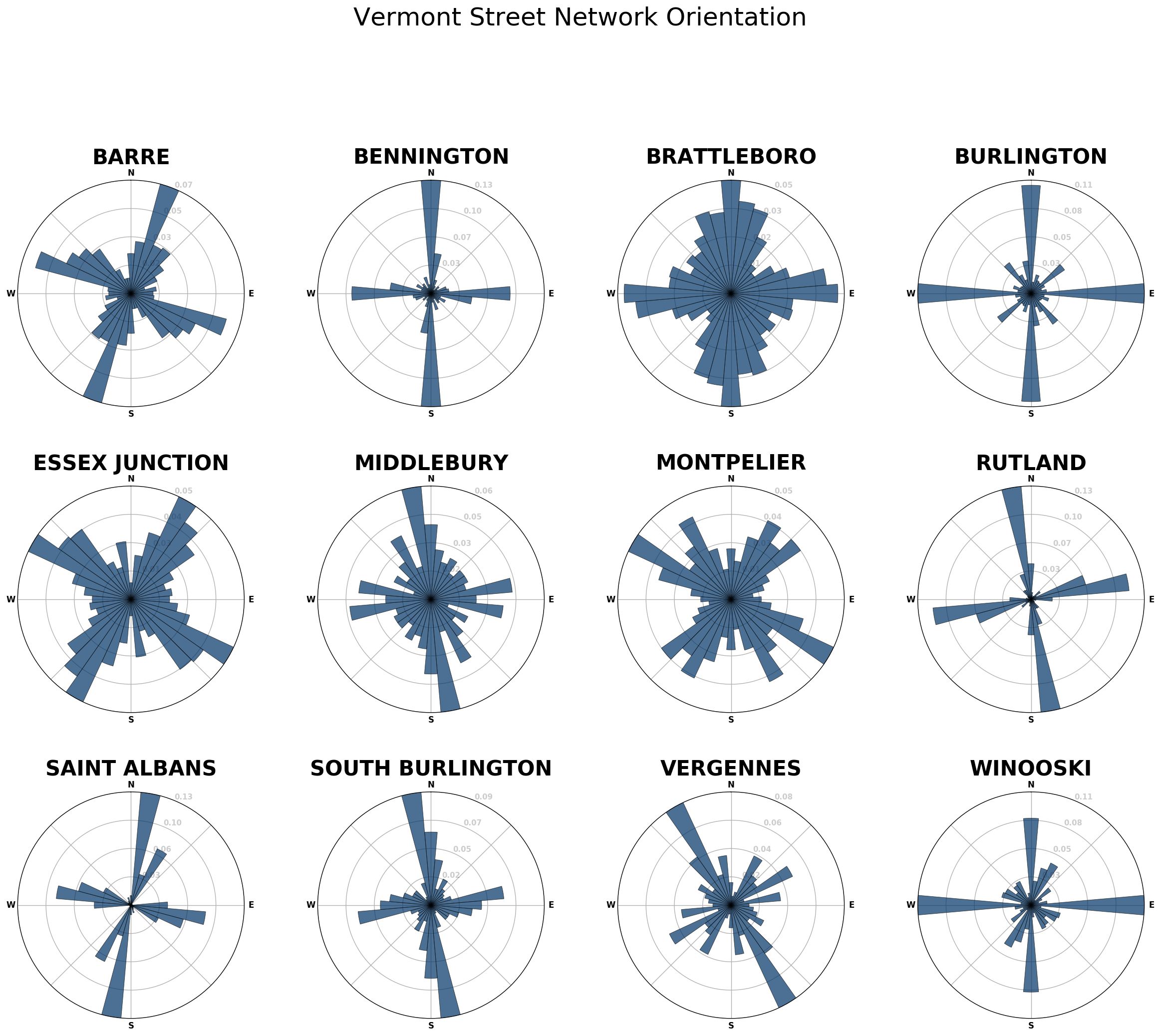
By now many folks have seen Geoff Boeing’s really neat charts of street orientation that highlight how “gridded” (or not) the layout of city streets are:

Since Geoff was kind enough to provide a full open-source tool-chain, I decided to tweak it to chart the orientations of the streets of some cities and villages in my home state of Vermont:

Street orientations of Vermont

Unfortunately, until I get around to importing Vermont town boundaries, not all towns will be super easy to include in this analysis.

Location: Middlebury Village Historic District, Middlebury, Addison County, Vermont, 05753, United States