 OpenStreetMap

Hmm, OSM Belgium published an interview with me about my mapping in Turkmenistan. You can read it here: https://openstreetmap.be/en/motm/2018/08/10/allan-mustard.html
Diary Entries in English
Recent diary entries

If M objects randomly change their characteristics every period (POIs open/close, buildings constructed/demolished, roads re-named/paved, etc.), while the OSM community checks and updates U randomly picked objects per period, then the accuracy of the map (the share of objects that are up-to-date) approaches 1/(1+M/U). Does anybody have guesstimates for the values of M and U?

We have various communication channels in OpenStreetMap being used for different needs in communication. The mailing lists and forum work reasonably well for free and open discourse of the community, changeset discussions allow communicating on specific edits in the map (and we have for example Pascal’s tool to look through these). We have the user diaries for people publishing their thoughts and experiences on the project and discussing them with others. And we have the OSM wiki which is used as a place to document things.
All of these have their issues and room for improvements but they are widely used and accepted as the platforms where communication happens. And they all have relatively low entry barriers as evidenced by the fact that quite a lot of people use them actively.
What we don’t have and where we have in OpenStreetmap a fairly obviously increasing need for is a means for project organization and related communication, task and issue tracking etc. There is a very old trac instance but this is hardly used any more and has a fairly awkward usability, in particular for non-programmers. Safe to say this is not an established communication platform any more.
Because of that people have started widely using external commercial platforms, in particular github, for this kind of work.
Specific examples:
- corporations doing organized edits have github repositories to track their work - like here, here, here and here
- import planning is frequently performed on github - like here and here
- there are attempts to move tagging discussion to github issue trackers here
- the OSMF and its working groups using github for issue tracking (both publicly and internally), public examples here and here
For OpenStreetMap this is not a good development for various reasons:
Posted by Emmanuel Chidera on 10 August 2018 in English.

Your SOTM US session was not accepted Hello!
Some time ago, you proposed a session for State Of The Map US 2018: “Extending Web Based Maps to University Campuses Using Openstreetmap”. Yours was among almost 100 high quality proposals competing for less than 50 spots. We had a pretty tough time narrowing down the list to create a great program for the conference. Unfortunately, your proposal was not among the ones accepted. Thank you for submitting a session proposal for State Of The Map US 2018! We hope you can still make it to State of the Map US 2018 in Detroit on October 5-7.
Your State of the Map US team
i feel very sad and heart broken. i believe i ill make it again.
All thanks to God Almighty who gave me the wisdom to design the UniqueMappersteam website. was not very easy because of other project i am currently running on, but i am so happy i have finally launched it live and t serves as my own contribution to the OSM COMMUNITY .
Posted by Emmanuel Chidera on 10 August 2018 in English.
my joy for the arrival of this devices cannot be over emphasized by just mere looking at my face. Thanks to HOT who assisted because it has being a great challenge to UniqueMappersTeam .this increased my mapping activities today, initially my record was very poor and now things are not the same as before.

On behalf of the organization where I work, World Resources Institute Mexico for the Latin America area, and also for my efforts as part of OpenStreetMap Mexico, I participated in the State of the Map 2018 in Milan. I got a scholarship from the organizers, for which I am very grateful. I presented a state of the art on public transport data standards such as can be used in countries not very advanced technologically speaking and with low technical capacities in governments to integrate data to urban planning, with the challenge then of promoting useful and timely information. I finally presented the interest for several global organizations, to allow improvements in this topic, to group and concentrate resources, approaches and debates: data repositories, technologies, data collection methodologies and also form a visible, accessible, friendly platform and perennial to link actors and share experiences.
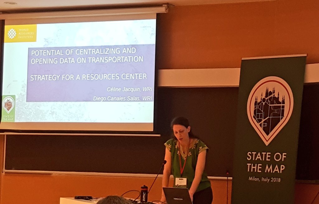 It can be viewed at minute 30:00 of the video of the event.

August 9,2018: We had a regular meeting in our CWTS++ program of MapAmore in Polytechnic University of the Philippines, San Juan branch which was headed by our director Mr. Erwin Olario. Our mapping program is more than a month now and we discussed the progress we had made in mapping specifically in the numbers of edits is around 6500 which includes 4199 buildings and covered 716 kilometers of roads. We validated almost all the missing roads in the Philippines and a few parts in Malaysia Laos, South Africa ,Russia, Canada and Cambodia. Even though the PUPSJ CWTS++ is just beginning its mapping program shows that its students/volunteers can contribute to the aspect of mapping whether in an emergency or not.
The first topic we had for today was about other Open Street Map Editors which was reported by our classmate Joshua Madridondo. The editors he shared was Potlatch 2, Merkaartor, Vespucci, StreetCompete, OsmAnd, Quantum GIS and ArcGIS. The editors stated has some pros and cons, like for Potlatch 2 it was easy to use which was good for beginners, displays the GPS traces in difference layers but requires a flash plug-in in the browser. While Merkaartor has unique features, intuitive user interface and binaries for Windows and other platforms. But it has a slow development and a small data base.
After that our director started to discuss the common issues and techniques about mapping.
•When you are in a task and the area you are mapping is not whole, then logically you would still map the entire area even though its other haft is in another task.
• In making roads you would like to copy the geometry of the road when you are mapping so that it would follow what it looks like, so creating addition nods are necessary. Additional you must connect roads in an entire area rather than creating a single line or incomplete ones. Indicate whether they are intersecting. Do not create another line on top of an existing road unless needed. Connect roads if necessary.

In Transfer files to/from Android 6 via USB under Devuan/Debian it was detailed how to setup both Devuan & the Android smartphone as to import/export files between the two devices. In this post, a script is given to quickly one-touch files from the phone to a designated directory in the desktop.
The script below will need saving into a file called ~/Personal/copyFromPhone. You will then need to:-
:~$ chmod +x ~/Personal/copyFromPhone
:~$ ls -al ~/Personal/copyFromPhone
-rwxr-xr-x 1 user user 1857 Aug  8 21:18 /home/user/Personal/copyFromPhone
The script is launched as :~$ Personal/copyFromPhone. The values $CAMERA, $FUSERMOUNT, … , $MOUNTPOINT will all need checking. $LOCAL + $MOUNTDIR are almost certainly wrong as provided for any specific user.
Problems:
The major problem I had was ‘device is busy’ reports on attempted unmount at end of script. Using the unmount command from terminal always worked (fusermount -u /media/user/disk), but I added the ‘lazy unmount’ option to try to get rid of that.
Posted by srikant123 on 8 August 2018 in English.
Last updated on 11 August 2018.

GSoC 2018 with OpenStreetMap comes to end and with it its the end of the most exciting summer I have ever had which have helped me grow and learn alot of awesome stuff from my mentors who guided me throughout my GSoC period.
Link to main github repository : gtfsintegrate.
Link to google docs where complete step by step documentation and implementation of application is described googledocs.
Feeds were downloaded from: TransitFeeds
The Three main views of the GTFS Integration application are: # 1. Feed entry Module In this view of the application user is presented with a form which consists of a feed URL field, name field and a frequency field(number of days after which the feed must be downloaded again). Celery tasks are defined which can run every few minutes checking all the feeds and downloading the feeds if the frequency exceeds when compared to current time-stamp. In the front-end part application shows whether the feed is present or whether the feed is updated to latest version in the Feed Download Status Block.

This is a mirror of a post on my blog.
After the birds of a feather session Richard Fairhurst lead at State of the Map, I was motivated to continue some work on bolder, a client-side style I’ve been working on.
While I was working at the Wikimedia Foundation, I developed brighmed, a CartoCSS style using vector tiles. Wikimedia decided not to flip the switch to deploy the style, but the style is open source, so I can use it elsewhere. Making this decision, I spent a day implementing most of it in Tangram.

What’s next?
I’ve got some missing features like service roads and some railway values to add, then I can look at new stuff like POIs. For that I’ll need to look at icons and where to fit them into colourspace.

Wrote this quick guide after realizing its not so easy to find how to do this.
Visible features
The easiest way to find more details about any feature that is visible on the map is to use the Query features tool. Use to to query the map features at any point to find the object you are looking for.
Alternatively, you can also use the search box and directly search by the name of the feature for matching results worldwide.

Deleted features
Deleted features that you know were visible in the past is slightly more tricky. You can use this Overpass Turbo Attic query to query all features in the map view at any given historic date to find the object you are looking for.
Tip:

This is a gist of all the work that was done during the summer of 2018 under Google Summer Of Code (GSOC) to further improve the PT Assistant plugin which assists mappers in mapping Public Transport systems.
Aim of the Project
To further improve the plugin in a way that it helps mappers in mapping public transport systems with ease. The assistant should become smarter by the end of GSOC and should act as a true assistant with smarter decision making capabilities.
Final Result
The plugin is now much more capable, processing the data in the background and presenting the result to enable the mappers to make decisions especially with new features like Routing helper, Double splitter, smarter Roundabout splitter etc. All the major achievements of this summer have been listed below :
Addition of Routing Helper button to the Relation Editor
A new button in the Relation Editor which aims to help mappers in fixing all the problems in a relation using options that the helper provides.
The Routing helper runs through the selected relation once the button in the relation editor is clicked. It searches for any kind of violation in the existing ways such as one way direction violation or overlapping of ways etc. Then it gives users options to remove those ways and suggests them some solutions in the form of options. The helper also checks if there is any gap present in the relation and thus it also tries to fix them by giving the suitable list of possible solutions as options which the mapper can select to make the relation correct. So the mapper now doesn’t need to care about the ways that are valid and that can be added as the helper already checks the validities and only then does it give any suggestion.
Posted by roadtrip-love on 7 August 2018 in English.
Last updated on 29 November 2018.
We’re currently enjoying life in
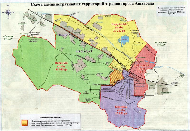
Today’s newspaper carried news and a map of an internal boundary shift of two of Ashgabat’s boroughs (“etraplar”). About 1,376 hectares of land has been shifted from Buzmeyin etrap to Bagtyyarlyk etrap. More map editing ahead.
The newspaper also said the mayor proposed annexing more territory into the city, which means it is highly likely the outer boundary of Ashgabat will change again in the foreseeable future. Even more map editing ahead!

It’s been a long time since our last post about OSMCha… In this period, we have implemented few features in the frontend, nevertheless we have done a lot of work on backend and prepared OSMCha to be compliant with the GDPR.
This backend work was necessary to avoid technical debt, make the system run faster and to have a good base to the future improvements. We updated the OSMCha backend to run with Django 2.0, Python 3 and Django Rest Framework 3.7.7. Other backend dependencies were updated as well.
GDPR Changes
It’s not on production yet, but we have already started testing a new version of OSMCha with the modifications required by the GDPR. The API and the frontend will show user metadata only to authenticated requests. It means that, if a request is unauthenticated, the fields 'user', 'uid' and 'check_user' will not be present. Furthermore it will not be possible to filter changesets by one of these three fields. The anonymous requests will not return an error, but the results won’t take in consideration these filter fields.
If you use the OSMCha API, our staging server is available to your tests, so you can verify the modifications needed by your software (Be aware that the staging server has only changesets older than 2017-09-26). To make authenticated requests, add to the header: Authorization: Token <your_token>. Your user token is available in the user page of the staging server (soon in the user page of the production too).
The saved filter (AoI) RSS feeds will have a different authentication method that we need to implement yet. The features API is yet exposing user metadata, but very soon we will do a big change to it. Instead of exposing a lot of information about the features, it will return just the id, type and suspicion_reasons of each feature.

This and future diary posts also appear on my blog.
After introducing MapRoulette 3, the micro-tasking tool for OpenStreetMap, I would like to follow up with a series of ‘Insider’ posts. Each of them will highlight an interesting feature or function of MapRoulette.
This week, we will look at Virtual Challenges.
Challenges in MapRoulette
MapRoulette consists of Challenges, which are groups of similar Tasks. An example is the Embassies missing representing countries Challenge by user johanemilsson. It asks you to add missing country=* tagging to specify which country the embassy, consulate or mission represents.

Posted by Chetan_Gowda on 6 August 2018 in English.
Last updated on 10 August 2018.

OpenStreetMap evolved since many years. Millions of contributors are helping this project to grow everyday. Inspired by some of my friends, Karnataka and Ireland evolution projects, I wanted to vizualize different parts of the world.
Sharing simple animated GIF that I created using Mapolution on Docker on my Mac showing different countries’ OSM edits over years. The snapshots are taken for every 30 days from the starting date.
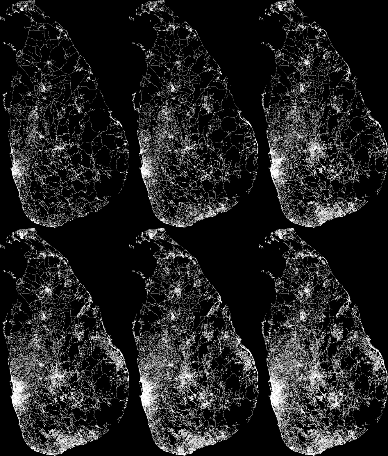 Sri Lanka (January 2015 - July 2018)
Posted by arnalielsewhere on 6 August 2018 in English.
Last updated on 7 August 2018.

August is the Philippines’ National Language Month. So I took the time to translate this diary in my local language, Filipino/Tagalog, which can be found here. _________________
Late last year I’ve been fascinated with the concept of and started advocating about “inclusive mobility.” For me, inclusive mobility refers to a state where everyone and everybody are free to move everywhere and have access to all modes of transit, and all roads and bridges are passable.
It was amazing to see and experience the streets of Milan. I believe they have reached the state of inclusive mobility where both automobiles and differently-abled pedestrians have been taken into consideration in the transport planning process.
Getting to SotM 2018 at Politecnico di Milano…
For this year, SotM was hosted at the Politecnico di Milano. There are a lots of ways to reach the venue. maps.me suggests either by car, walking, cycling (bike share programs are available in Milan but I wasn’t able to try it :( ) or train (but no tram?). In the first day of the conference, I traveled alone because I woke up late and I didn’t want my mates to wait. But they instructed me how to go there (thank you Geoffrey and Tima!). I opted to take the subway from Republicca to Milano Centrale to Piola. At Piola, I found myself walking towards the wrong pin location and walking around the area for 40 minutes under the heat of the sun! I was so lost that I decided to ask a stranger to point me in the right direction (thank you!).
So yeah, I missed 1/4 of SotM Day 1. But good thing there are recorded videos of the whole conference which can be found in Youtube.
Inclusivity, diversity and representation…
Before writing this diary, I watched the keynote address by Kate and Heather which I missed. Heather discussed the 5 components/values of being an “open” organization/community by OpenOrg. One (1) of it is inclusivity, which she stressed to be one of the hardest part.

In the last few days I’ve been working at adding schools in the Azores. The Azores islands have a lot of these, scattered along the villages and cities of all islands.
Work consisted of adding buildings, pitches, roofs, and creating amenity=school areas on school grounds of all schools managed by public entities. Additional information such as addresses and contacts were also introduced.
Here’s the changeset: osm.org/changeset/61385366
Emanuel