Diary Entries in English

Recent diary entries

Posted by alexkemp on 4 May 2017 in English. Last updated on 3 July 2022.

Wood Lane is possibly the original heart of Gedling Village (although after a talk & a meal with the elders of the local tribe last Wednesday, 3 May, I’m moving that node close to the 1,000-year-old All Hallows Church, near the area that the villagers themselves call “Gedling Village”). The average recent prices of houses in Wood Lane is ~£500,000 GBP (€590,000 EUR; $650,000 USD), which is 3 or 4 times a typical price for Nottingham. Much of the area is a Private Road (unadopted), but I’ve got to say that the folks there are most welcoming & not at all snooty (my grandkids & their mum visited me this last Bank Holiday and, after looking at some recent Diary postings, we all decided to take Buddy, their dog, in a walk through Gedling House Woods & Meadows, and had a fantastic time making friends with other, local dogs; Buddy enjoyed it as well).

I had a similar warm welcome & assistance from Dr Soar at Gedling Manor:–

Gedling Manor

See full entry

Location: Rivendell, Stoke Bardolph, Netherfield, Gedling, Nottinghamshire, East Midlands, England, NG14 5HH, United Kingdom
Posted by Dotevo on 4 May 2017 in English.

Regarding my previous Esperanto post I want to write something in English. I’ve created a map with names in specific language (a few here). And also I’m using a few not popular tags but I thing that should be important in future.

https://github.com/dotevo/esperantmapo/blob/master/gulp/el%C5%9Duti.js#L32

  • language:[LANG_CODE]=yes
  • books:language:[LANG_CODE]=yes

Why I think those tags are interesting and important? If you know place where a specific language is supported, you should add that information. It can be very helpful if you’re tourist (hotels) or you looking for something. Example in country X you are looking for book in language Y. What next? Movies?

BR, Adam

During recent months, we have seen a lot of new user activity and pokemon targeted feature mapping on OSM. This correlated with observed/assumed association of pokemon spawn points with OSM features by PokemonGo players.

From my observations on reviewing changesets, some features are mapped very specifically for specific pokemons. Some of these features are parks, meadows, waterbodies, gardens, protected area’s, village_green’s, natural reserves, golf courses, cemeteries and forests .

So I made these comparators in OSMCha that flag a new user’s(<=10 changesets) changeset if one of these features have been added brand new(Version 1).

1. Park features added by new users

  • This reason flags a changeset if there is a creation of these features in it
  • recreation_ground, village_green, park, nature_reserve, protected_area, national_park, garden

2. Waterbodies added by new users

  • This reason flags a changeset if there is a creation of these features in it
  • natural=water, water=, landuse = pond or reservoir, waterway=

3. Pokemon nest features added by new users

  • This reason flags a changeset if there is a creation of these features in it
  • recreation_ground, park, pitch, playground, golf_course, meadow, grass, cemetery, grass, forest

One can combine reasons in OSMCha and look at changesets now, add bboxes to specific areas and share permalinks. Ex: All pokemon based reasons in Germany.

From our experience validating, a lot of this mapping is really good and rarely do we find any suspicious edits. Let us know if you find these useful or if I need to tweak them based on changing Pokemon trend.

Screenshots of some really interesting mapping activity I have come across

See full entry

Last week I went twice to visit (and map!) the ruins of an old sawmill, called Älsebo såg in swedish. There were two POIs on openstreetmap, but I wanted to check it out to see if I could map some areas also, and perhaps roads as well.

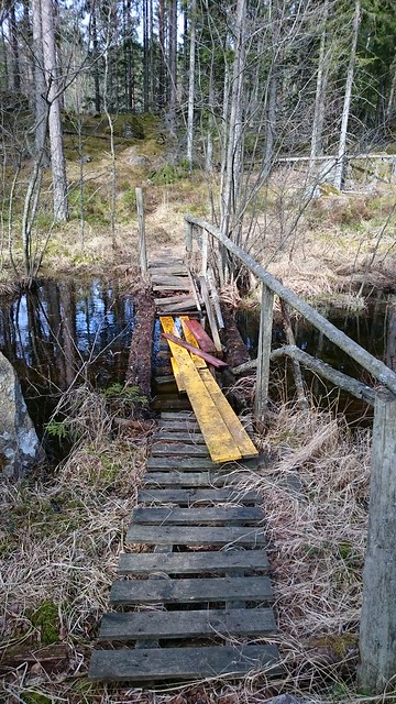
The first time I was out biking and mapping in the forest. I knew from studying an old map that there was supposed to be an old disused road in the forest. These are among my favourite things to map and so I was very happy to find the road in the forest. Unfortunately there was a stream crossing the trail, and the bridge was more or less nonexistent:

Not the best bridge I've crossed

It was possible to cross but very difficult to also get my bike across at the same time. I considered throwing the bike, but since it is only two months old I’d rather get wet instead. But I managed to get across.

See full entry

Location: Älsebo, Kvillinge församling, Norrköpings kommun, Östergötland County, Sweden
Posted by GOwin on 3 May 2017 in English. Last updated on 23 May 2017.

Ala eh OSM - the Basic Mapping Workshop

imgAOI Click the image to view the details via Overpass Turbo query.

Last week, a few OpenStreetMap advocates from Metro Manila made a trip to Batangas for a training engagement with the Bayanihan Mapping Workshop co-organized by MapPH and their partners. OSMph has had extensive engagements with some of MapPH efforts in the past years, and we continue to work with them in common spaces where we can collaborate.

The workshop was attended by over fifty enthusiastic participants, mostly from the respective Disaster Risk Reduction Management (DRRM) office, or the Planning and Development offices of the local government units within the Taal Volcano Protected Landscape (TVPL), about a third of the municipalities of Batangas province:

  • Agoncillo
  • Alitagtag
  • Balete
  • Cuenca
  • Laurel
  • Lemery
  • Malvar
  • Nasugbu
  • Taal
  • Talisay

See full entry

Location: Barangay 20, Poblacion, Batangas City, Batangas, Calabarzon, 4200, Philippines
Posted by dieterdreist on 3 May 2017 in English. Last updated on 5 May 2017.

I only recently discovered that Jochen Topf has published a command line tool based on his great Osmium library. The Osmium library is a C++ library optimized for working with OSM files in different formats like XML and PBF and is very fast. While the original library is geared towards developers (besides the c++ version there are also python and node bindings), the command line tool is great for normal users.

To give it a try, I decided to have a look at an Italy extract from Geofabrik I had downloaded in March and which was still lingering on my disk. Linux and Mac users know, the great potential of the shell lies in the ability to perform multiple commands in sequence by piping the output of one operation to the next tool in the chain.

Here is what I used to get a list with the last modifiers (mappers) of every object in the file, sorted by the number of contributions (only current version of undeleted objects have been counted here, but Osmium-tool also allows for analyzing full history files if I am not misguided):

osmium cat 20170302_italy.osm.pbf -f opl|cut -d' ' -f7|cut -c 2- \
         |sort|uniq -c|sort -nr|head -n 250 >italy-top250.txt

I’m not very good in using the shell, so maybe this command line can be improved, feel free to suggest improvements in the comments.

The binary extract I used is 1.2GB and was sitting on a network share and I was using a slow dual core MacMini (this is why there aren’t spaces around the  pipe symbol, the Mac shell doesn’t like them) so it took a while (maybe half an hour), also because the sort command in the shell takes some time, but IMHO this is totally acceptable for occasional use.

In case you are interested, this is the output (I have numbered the lines with cat -n. Unfortunately there seems to be a bug or a feature so that the markdown in this diary is removing the newlines). Needless to say, many of the higher ranks have been “cheating” by importing big amounts of data ;-)

See full entry

Location: Campitelli, Municipio Roma I, Rome, Roma Capitale, Lazio, Italy

Can you introduce yourself ?

The last years, my main occupation was OpenstreetMap. I was also one of the co-founders of OpenStreetMap Belgium. I am a self-employed and freelance software developer, usually related to routeplanning.

Furthermore, we love to travel, our daily amusement is often a visit to a pub with some friends or having a nice dinner at a restaurant.

Where and when did you learn about OpenStreetMap ?

I needed data about the road network for my job and soon you arrive at OpenStreetMap. This was in 2009 and it did not look realistic at that moment to use OpenStreetMap data, but I was intriged by the concept and in the following years, it proved to be the right choice.

##Do you use OpenStreetMap yourself ? I constantly use OpenStreetMap, both for my job and my private life. I never vist a place without an offline map of the region on my smartphone. I use OpenStreetMap daily for my job.

How do you map ?

The past few months I have not mapped a lot. I am more of an “armchairmapper”, but I strongly believe in the community, no OpenStreetMap without community. Only individual mappers behind a computer would never work well. From time to time I correct mistakes or small this that are missing that I notice by using the data, but usually I am too late. Occasionally I do some mapping for Missing Maps and Hot, mostly validating tiles.

What do you map ?

I do not really have a speciality, but when I have to pick one, it is everything related to road network and transportation. In my early days I also traced a lot of buildings and mapped quite some landuse.

What is your biggest achievement ?

That we created a real community in Belgium. At the first meetup we organised in Ghent, only one person showed up. Now, a few years later, we organised the State of the Map !

See full entry

The journey of OpenStreetMap community is a perfect example of community volunteerism approach. Despite any structural funding the community made it’s own mark in the global humanitarian arena. The continuous support from HOT, MissingMaps & recently Mapillary boosted the enthusiasm of the community and inspired them to go far beyond.

However, in recent times the necessity is felt to give the community a organizational structure. Keeping this on mind most recently a group of very active and experienced members of the OSMBD community has just formed an OSM based innovation lab BHOOT (Bangladesh Humanitarian OpenStreetMap Operations team).

The main objective is to make the OSMBD community more active & vibrant and lead the community towards sustainable future. It’s not yet been started as an registered organization but there are plannings on that. The team have been preparing the plans to conduct a full scale field mapping in a disaster pruned area of Bangladesh. The team has already initiated a project in Belkuchi area of Sirajganj district and planning for a street mapping project for the whole Dhaka Metropolitan.

The plans for both of the projects includes but not limited to creating a detailed base map of the areas, develop an data collection application tool for OSM field mapping, integrating Mapillary street level photos to the map and conducting some field level researches.

Dear All,

I have been in around 35 countries around the world and I noticed Belarus is the only country that appears on Openstreetmap in a different language than on-spot. To be more precise, all names appear in OSM in Russian (Островец, Осиновка, Ошмяны for example), but when you drive there, everything is written in Belarusian (Астравец, Асінаўка, Ашмяны for instance). I’ve got nothing against Russian language (which is definitely more spoken in Belarus than Belarusian). However, I think we should start ASAP to correct that mistake and make Belarusian village, town and city names the main ones. In some cases even street and public transport names (in Minsk these things appear in Belarusian). The purpose is simple: for instance when you use maps.me (a GPS app that uses OSM), if you drive to Asinaŭka. it appears “Asinaŭka” and, just below, the name in Russian (Оснивока). However, when you arrive to that village, you see “Асінаўка”. It is extremely confusing for travelers, especially if they don’t read cyrillic.

Another question: multilingual names in Europe. Numerous cities, towns, and villages appear with bilingual names on spot (but on OSM their main names appear only in one language). It would be good to make those names appear as they appear on spot.

How do you think?

Posted by 3ngineer on 29 April 2017 in English. Last updated on 22 May 2017.

Sometimes I wonder if the ability to define such specific details actually makes the map more confusing and inconsistent rather than informative. By no means am I an expert, but I have a feeling that there’s a lot of info that’s practically not needed. The ability to add it just makes people fight and unhappy with others’ judgement. Also, the map can become confusing when very similar types of things are drawn different ways; I think that contributes to OSM’s messiness. Nevertheless, if we take out too much info, we would just become Google maps XD so perhaps just ensuring similar things have similar styles is the best approach.

Today I was asked by another (very active) mapper via email these questions:

We are currently discussing best practices for landuse mapping in Belgium. Some of the problems:

  • do you use multipolygons to avoid overlapping landuse or do you split a residential landuse so you can have smaller landuses ? Or do you just overlay them ? A lot of landuse is already mapped in a rough way, so we typically have large areas of residential landuse.
  • Do you include streets in residential landuse or do you exclude them so one can later add area:highway or landuse=highway ?
  • I’m in favour of landcover to avoid “forests” in gardens. Which landcover proposal do you follow ? (I believe there are 2).
  • what about grass/bushes in towns near highways ?

I wrote some lines how I believe it should be done. Here’s a slightly modified version:

Residential landuse

Regarding the residential landuse, I am since almost 10 years advocating to not include roads but end the landuse at the property borders. Not only does it add more detail, because you can clearly distinguish (even without roads), parcelled land and common land, it will also be easier to add landuse=highway, i.e. the land that is legally a road. It just makes no sense from a legal point of view to add streets to the residential landuse (save maybe those areas where the streets are private). I do include driveways though, i.e. “roads” on the properties.

Clearly, public roads are road landuse, so they must not be included in residential, industrial, commercial, retail or other similar landuse.

why do people often use huge polygons including whole settlements in one landuse object?

IMHO the 3 reasons for people to include roads are

See full entry

Posted by jinalfoflia on 28 April 2017 in English.

OpenStreetMap is an integral part of Mapbox, I’m happy to share the announcement about our new logo with the community! 🎉

The logo is a helmet of an astronaut and my favorite part of this logo is that it reinstates Mapbox’s culture of curiosity and passion! It showcases the team’s vision and enthusiasm towards new opportunities. The star that you see in the astronaut’s helmet demonstrates our spirits to reach new heights! Know more details about the logo here.

33284852904_49008d0641_o

Though we have a new look and feel, we still continue to be the Mapbox that you all know. Our commitment towards improving OpenStreetMap data remains the same and so is our attribution around OpenStreetMap! ✨

Posted by mmahmud on 28 April 2017 in English.

28th April, 2017

Well, this was a personal goal of mine to Map in every single country in the World with OpenStreetMap. Well, mapping in every country is easy so I took it upon myself to make at least 1000 changes in every country. So, today finally that goal is achieved.

I mapped in all 197 countries in the World and made at least 1000 changes (Except in Vatican City because that place is too well mapped).

Country list: https://www.countries-ofthe-world.com/all-countries.html

https://www.state.gov/misc/list/

You can check it here: http://hdyc.neis-one.org/?mmahmud

Notes:

Palestine is shown as West Bank and Gaza Strip combined.

New Caledonia and Guadeloupe are states of France.

Western Sahara is part of Morocco.