Diary Entries in English

Recent diary entries

Posted by rphyrin on 17 August 2026 in English.

Several weeks ago, my bicycle finally got fixed, after being abandoned in a broken state for a long time.

Before that, I didn’t even know that my bicycle was actually broken.

All I knew was that this bicycle was really, really, really tiring to use. Even a short-distance trip was enough to tire me out for the whole day.

I didn’t know that this was caused by something being broken, which meant I had to put in (approximately) twice the effort to make it move (citation needed).

At that time, I simply blamed my own weak body. “Maybe I’m not strong enough to wield this bicycle,” I thought, dejected, considering giving up my whole cycling career prematurely.

Then, one random day, one of my family members used that bicycle, noticed something wrong with it, fixed it, and then it was finally ridable without needing much energy and force.

Alright. Now I can use my bicycle again, I guess.


For short trips, I usually prefer a bicycle to a motorcycle, for several reasons, you name it : hiking gas prices, the need to reduce our own carbon footprint to save the Earth (back then I took the mandatory environmental college course and thanks to that I’m still brainwashed so hard about the need to reduce my own carbon footprint), a nice opportunity to exercise my body, and the previous trauma of using a motorcycle and then suddenly having the engine not start so I had to walk the motorcycle to the nearest repair shop which turned out to be not near at all. Yeah, plenty of reasons.

So this afternoon, I decided to take a long trip to several places in my town, using my recently fixed bicycle.

I started around 4 PM and went home again around 6 PM.

Now it’s night, I’m sitting in front of my laptop, and getting curious : how many kilometers did I traverse this afternoon while cycling?


I didn’t bring a proper GPS device to record my trip this afternoon, but I remember each path that I took today. So, what should I do to calculate the distance?

At first, I tried BRouter.

See full entry

Using OpenStreetMap Data to Understand Digital Platform Locations

OpenStreetMap provides a collaborative source of geographic information created and maintained by contributors around the world. For developers and digital-project teams, mapping data can be useful when building location-aware websites and applications.

Why Mapping Data Matters

Location is an important part of many digital services. A platform may need to display cities, roads, landmarks, businesses, transportation routes, or other geographic information.

OpenStreetMap can help developers understand how geographic information can be represented and visualized.

Exploring a Location

When exploring an area with OpenStreetMap, users can examine different types of geographic features, including:

  • Roads and streets
  • Buildings
  • Places and landmarks
  • Public transportation
  • Shops and businesses
  • Parks and other geographic features

The information available depends on what contributors have mapped in that area.

Mapping and Digital Projects

Location data can be useful for many types of projects, such as:

  • Travel applications
  • Local discovery tools
  • Community mapping projects
  • Delivery and logistics systems
  • Emergency-response applications
  • Educational mapping projects
  • Location-based websites

Developers can combine mapping data with web technologies to create interactive experiences.

Data Quality and Verification

One of the important lessons from collaborative mapping is that geographic data should be checked carefully before being used for a specific purpose.

Road names, addresses, business information, and other map features can change over time. Contributors can improve the map by documenting real-world information and correcting inaccuracies.

A Practical Mapping Workflow

A simple workflow for a digital mapping project can be:

See full entry

Posted by CodentGIS on 17 August 2026 in English.

Oh, where do I start?

It was around October when I had recently imported the barangay boundaries of my hometown, Cauayan City. I had just asked the GIS team at the local Planning and Development Office to adjust the boundaries again, as many issues were identified in the dataset. A while later, I had an idea to try to help the GIS team adjust the boundaries, because I figured, “Why not?” and they’re probably doing a lot of work already, given so many developments in the area.

The current flawed official map

A little back and forth, but then they stopped responding. I mean, it is basically a 50/50 chance that they respond or not. A little later, I dove into further research and stuff, and I thought of asking an institution to collaborate with me on making a dataset for the PDO to use and merge with theirs, so it can be as accurate as possible (I like things accurate).

See full entry

Location: District I, Poblacion, Cauayan, Isabela, Cagayan Valley, 3305, Philippines
Posted by rphyrin on 16 August 2026 in English.

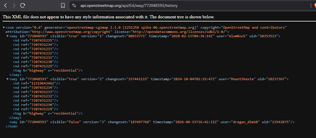
One thing that usually worries us as OpenStreetMap mappers is having our hard work deleted by someone else, either accidentally or intentionally.

Thankfully, our edits are still in the database.

The delete operation in OpenStreetMap is not really a delete operation. It simply flips the object’s visible flag from true to false, while retaining its entire history.

And you can resurrect them using JOSM’s “Undelete Object” feature, as long as you have the OSM object’s ID.

See full entry

Digital maps have become an important part of modern web applications. From finding businesses and transport routes to understanding geographic patterns, mapping technologies allow users to interact with information based on location.

OpenStreetMap is particularly interesting because its map data is created and maintained by a global community. The OpenStreetMap website also provides user diaries where contributors can share experiences, technical topics, mapping activities, and community projects.

Why Location Data Matters

Location can add useful context to many types of digital information.

A web application can associate information with:

Cities Regions Roads Buildings Sports venues Businesses Public facilities Transport networks

For example, a sports-information application could use geographic data to identify the locations of stadiums and other sporting facilities.

Mapping Sports Venues

Sports data and geographic data can be combined to create interesting applications.

A simple dataset might contain:

Field Description Venue Name of the sports venue City Location of the venue Country Country where it is located Latitude Geographic latitude Longitude Geographic longitude Sport Sport associated with the venue

This information could then be displayed on an interactive map.

OpenStreetMap Data

OpenStreetMap provides geographic data that can be used in many mapping applications, subject to its data licence and attribution requirements.

A developer can use map data to create applications for exploring roads, buildings, landmarks, transportation infrastructure, and other mapped features.

The OpenStreetMap ecosystem also provides tools and editors that allow contributors to improve geographic information.

A Simple Web Application Concept

A location-based sports application could follow this structure:

Sports Data ↓ Venue Database ↓ Geographic Coordinates ↓ Mapping API / Map Library ↓ Interactive Web Map

See full entry

Posted by HRZA on 15 August 2026 in English.

I’m undergoing the learning path “Open Mapping Essentials” on HOT´s learning centre. In the process I have contributed by mapping local businesses and housing buildings in Managua. I also added a few rural roads in the Esteli area. All my changes are based on local knowledge of the areas. I am looking forward to contributing to the OSM and HOT communities.

Location: Planes de Altamira 3, Los Robles, District I, Managua, 14042, Nicaragua
Posted by Loopslol7 on 14 August 2026 in English.

Hi guys.

I would like to emphasize the benefit that the micromapping of certain features can contribute to unhoused communities. Of course, there still needs to be more awareness of OSM within these communities, but the data being there is great for the future and making the map more useful.

Tagging if the seats on benches are separated or not allows people to know where they are able to lay down and thus sleep if they don’t have access to other places to sleep. The tag seats:separated=yes/no is used for this purpose. Ive been adding this to every bench I map. Tagging benches that are not separated is just as important as tagging benches that are.

Drinking water is needed for all humans to live. Knowing where the nearest water fountain is, or the nearest convenience store that will let you fill up a water bottle from their fountain drink dispensers, can be super useful and help when times are tough. Consider looking out for drinking fountains at parks and other public places.

Hope you got something from this, happy mapping and I hope you have a nice day.

mahakal book This diary entry explores how modern web technologies can create accessible and responsive digital sports experiences. It looks at user-friendly navigation, mobile-responsive layouts, organized sports information, interactive interface elements, and the role of technology in connecting online communities. The project focuses on design and digital experience while considering how clear and reliable information can improve the way users explore online platforms.