Posted by pedrito1414 on 6 May 2026 in English.
Hi all, if anyone is attending the World Urban Forum in Baku, Azerbaijan and wants to organise an OSM / open mappy meetup with me, please reach out or comment on this diary :)
Hi all, if anyone is attending the World Urban Forum in Baku, Azerbaijan and wants to organise an OSM / open mappy meetup with me, please reach out or comment on this diary :)
Hi everyone,
I’m currently using the Valhalla API for routing, and I recently started experiencing some issues (e.g., slow responses / failed requests / unexpected results).
The issue occurred on May 4th at around 5:15 PM (Egypt time, UTC+2).
I wanted to check if there is any ongoing outage or known issue with the service at that time.
If anyone else faced similar behavior or has any insights, I’d really appreciate your help.
Thanks in advance!

The original work Tout savoir sur la license ODbL : la licence d’OpenStreetMap pour cartographier en commun was written in French in 2024 and updated in 2026 by the Fédération des Pros d’OSM, a French organization that brings together various companies and professionals working with open data, OpenStreetMap, and related software. The authors of the original booklet are: François Lacombe (Datactivist), Florian Lainez (Jungle Bus), Antoine Riche (Carto’Cité) and Christophe Biez (Latitude-Cartagène Cartographies).
The English translation was prepared by Editora IVIDES and translated by Raquel Dezidério Souto (IVIDES DATA® and IVIDES.org®) and Modo Levo Engelbert Steve (OSM ENSTP and OSM Cameroun).
The work is licensed under the Creative Commons Attribution-ShareAlike 2.0 France (CC BY-SA 2.0 FR). Text of the license

Every three years introvert communities from three Baltic countries try to gather together in one city and discuss things they’ve been doing. It is called SotM Baltics, and this year the conference comes again to Riga, Latvia. It’s in less than a month: 4th of June!
We’ve got just one day, and not a weekend even. But there will be many GIS professionals in neighbouring rooms (with their own conference), and generally the event will definitely feel like an oasis of open mapping.
I would like to invite you — whether you live nearby, or can fly in for a couple days — to attend and maybe present at the conference. There will be video recordings, and more importantly, a free lunch for everyone. And both the city and the weather promise to be splendid.
See the website for info and forms: https://2026.sotm-baltics.org/
For the next day I’m thinking of organizing either a workshop or a bicycle ride, whichever looks more fun.
Hello
1999 and tomorrow it’s 2000, deus volente, and HAL goes off the year after.
Today I did mapping in Baucau. I added some new roads and buildings that are not in OpenStreetMap. I am happy to be able to help the community get a better map.
Hello,
Below I have compiled recent news related to the OSM Foundation (OSMF) board’s work. Most of these are or are going to be publicly documented on the OSMF website, so if you follow the Atom feed for the board meetings’ page, you can skip this.
It contains my personal selection and recollection of recent OSMF board-related updates.
It is not intended to include details or all OSMF board-related updates. For these, you can refer to the published board minutes. This entry has not been reviewed by the OSMF board.
Informing the OSMF members is important. The board minutes describe in detail what was discussed in public board meetings, but many people don’t have time or follow the Atom feed for the OSMF’s website recent changes. At some point, I was creating annual or more frequent updates for the whole Foundation, which was a lot of work during a short period, while other tasks were ongoing.
I’m posting this experimentally, and I’m going to see whether I can continue to do so semi-regularly.
The 2026 budget of the OSM Foundation is now published. You can find previous budgets here. Please note that the board may revise the budget throughout the year.
The board had a meeting on Thursday, 30 April 2026.
You can read the Secretary’s report by Dani Waltersdorfer and the Treasurer’s report by Roland Olbricht.
Craig Allan (Chair) committed to informing the community about the status of the OSMF’s move to the EU, after a comment by Simon Poole (former OSMF and LWG chair) during the April board meeting.
OSM US Inc: The OSM US and OSMF Boards had a closed, introductory meeting on 2026-04-09. The OSMF board, after a comment by imagico (guest) during the April board meeting, said that it is open to meeting with other OSM Local Chapters, if they are interested.
TomTom Mapping Project Progress
🖋 Project Status: Active (Working on TomTom Map Tasks)
🏆 Achievements:
🧭 Completed approx 60%
💪 Strong position on the Leaderboard
🔐 Key Focus Areas:
🗺 Map Editing
📋 Note Resolution
✅️ Data Accuracy
🎬 Future Action Items:
🤝 Join the next OSM Virtual Meetup via laptop for better participation.
👥 Discuss technical hurdles and mapping issues with the community.
Arbuckle is a small community of about 3500 people in southern Colusa County. My husband and I stop through there a few times a year as we head north. It has gas stations and a fantastic Mexican restaurant on 5th street.
So it seemed like a good place to focus on mapping. I have about 100 homes left on the north west corner of the community. I started the project in January on business trip to Chico.
While browsing Taginfo I got curious how many elements have at least one key described on the Wiki and how big share of all keys the described ones make up. Therefore, I decided to check it out.
The analysis consisted of the following parts:
CREATE TABLE elements AS SELECT kind, id, tags FROM ST_READOSM('planet-latest.osm.pbf');;CREATE TABLE elements_keys AS SELECT kind, id, UNNEST(map_keys(tags)) FROM elements;;These are queries I provided to DuckDB:
| Result | Query |
|---|---|
| number of all elements | SELECT COUNT(*) FROM elements; |
| number of tagged elements | SELECT COUNT(*) FROM elements WHERE tags IS NOT NULL; |
| number of elements with key(s) described on the Wiki | SELECT COUNT(*) FROM (SELECT DISTINCT kind, id FROM elements_keys WHERE "key" IN (SELECT "key" FROM 'keys_wiki.csv' WHERE in_wiki)); |
| number of all keys | SELECT COUNT(*) FROM (SELECT DISTINCT "key" FROM elements_keys); |
| number of keys described on the Wiki | SELECT COUNT(*) from (SELECT DISTINCT "key" FROM elements_keys WHERE "key" IN (SELECT "key" FROM 'keys_wiki.csv' WHERE in_wiki)); |
I got the following results:
Teaser/screenshot from UrbanEye3D development version. Sport grounds with markings.
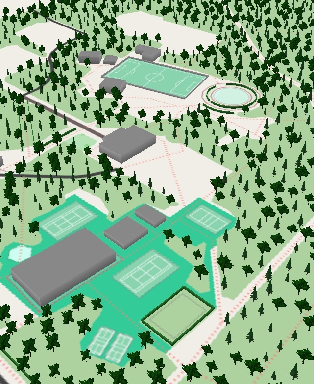
Can you identify the sports? ;)
Resolution could be higher, of course.
I often need to create a single GPX file from multiple related but different GPX files from Garmin and Wikiloc. My use case is finding route recommendations for running based on GPX files. I try to get a single GPX file so I do not have to juggle multiple files during the run. Original GPX files are also noisy, so the added advantage is having a precise path to navigate instead of dealing with GPX noise.
I start by putting all downloaded GPX files into a single directory and plotting them on the map. This step allows me to see them in relation to each other and spot any outliers early. I then simplify each GPX file to reduce the number of points and match them to OSM ways. I filter the points to make them evenly spaced. Finally, I use the OSRM trip service to create a single combined GPX file, or fall back to the minimal number of split files if they cannot be merged into a single file. I plot the resulting GPX files and simplify them to reduce the point count. Now I can sync them to Garmin and use them as a kind of basemap on a device that does not support basemaps.
Of course, this only works when I know the area in advance, can find enough existing route recommendations, and there is a reasonably complete OSM map. The current pipeline is error-prone and I find myself tweaking it to make it work with any specific set of GPX files. You can try it yourself and view the complete code on GitHub: https://github.com/evgeniyarbatov/gpx-courses
Short version:
Recently, I wrote a script that could help with OSM DB data replication using osm2pgsql by filtering .osc files with a specific .poly. It doesn’t limit to a specific continent or country, it can be used with any custom PBF (e.g. a specific city), so it doesn’t need to use .fr replication, it uses planet.osm.org directly (which also could be changed).
It’s inspired by the trim_osc.py script by Zverik, but rewritten from scratch with tests, because the script unfortunately didn’t work for me (maybe I did something wrong).
It’s not a very typical thing, so I’m not sure if it will be useful for anyone, but if someone would like try to self-host a regional OSM DB with replication, I recommend to at least checking it.
More details in the repo: osm-replication-osc-poly-filter
Longer version:
A few months ago, I was looking for an alternative for public Overpass instances (due to overloaded servers) for my projects.
I read SomeoneElse’s diary about self-hosting Overpass instance. But it seems over-complicated to me. I also read many times that there are random issues with reliability and it’s time-consuming to maintain it (not sure how true it is).
I decided that I want to switch to something else for my projects. Something more low-level with greater control of data and more likely self-hosted to avoid such problems. Instead of OverpassQL. I switched to SQL with a PostGIS DB. There are no a lot of choices here, so I chose osm2pgsql.
Osm2pgsql is quite advanced tool, which I really recommend at least reading about it – it may require some time to learn it, but it’s worth to seeing some features like --output=flex, which allows
to defining custom table schemas in Lua scripts with tags/geometry columns which works when importing and appending (replicating) data. It can be adjusted and optimized per project.
SORTA operates MetroNow, a microtransit service covering four zones in Hamilton County: Blue Ash/Montgomery, Springdale/Sharonville, Northgate/Mt. Healthy, and Forest Park/Pleasant Run. The service is powered by Via Transportation, whose routing engine consumes OpenStreetMap as its base map layer.
I am a daily MetroNow rider. A persistent routing failure at my address led me to inspect the OSM data that Via’s routing engine depends on. What I found on one street turned into a zone-wide audit. The results are significant enough that I want to share them with the local OSM community and ask for help.
A residential street in the Blue Ash zone carries two defects from the TIGER/Line 2008 Census import. Both carry tiger:reviewed=no. No human has verified this data since import.
False oneway=yes tag on a two-way residential dead-end street. The false one-way tag makes the routing engine calculate entry with no legal exit. The engine marks the street as unreachable. Drivers get redirected to a neighboring street. Riders get circuitous routes that bypass the correct address entirely.
Disconnected node gap at a cross-street intersection. Two ways representing the same street do not share a node. The routing graph treats the street as two separate, disconnected segments.
For a transit-dependent rider with mobility limitations, a routing failure is not an inconvenience. It is a service denial.
I ran the following Overpass query across the Blue Ash/Montgomery zone:
[out:json][timeout:90];
way["highway"]["tiger:reviewed"="no"]
  (39.16,-84.44,39.24,-84.33);
out tags;
Results:
After I got some experience with hosting OpenStreetMap tiles during the revival of Openptmap, I wanted to dig deeper into the topic in order to firstly migrate Openptmap to the new flex output so that it can receive incremental updates, and secondly to be able to host some additional overlays.
I found that the only widely used way to host tiles is overv/openstreetmap-tile-server. On the first look, it is really easy to use. It takes care of importing and updating the OSM database and of rendering and serving the tiles. On the second look however, there are some major challenges and problems with it:
I was looking for a house and decided to use OSM to help me find the optimal location. I had several fixed conditions: I knew my office location and I was looking for a condo close to a primary school. I used OSM to extract all schools and residential buildings. As there were many residential buildings, I used DBSCAN to find clusters and pick one representative building per cluster. To reduce the number of routes to compute, I used the OSRM table service to filter schools and houses within 5 km of each other. Then I ran the OSRM route service on triplets of (home, school, office). I saved the route polylines and locations into a CSV file, then created a KML file based on it and imported it into Google My Maps for visualizing the results. The resulting map is useful for getting a first impression of possible places to live. I am getting quite a few schools and houses to choose from, but I still find it valuable to have a view of the entire city that does not depend on what I happened to find first.
I’d like to announce the release of a new Docker container instance for Overpass.
I’ve been running Overpass locally for a couple of years and have dealt with some reliability issues by improving the shell scripts that drive database updates.
I’ve been sharing those shell scripts with people but I wanted a better way to distribute them. So, I put some effort into cleaning up the scripts (with some significant improvements – see below!) and packaged them in a container build.
There’s already the excellent wiktorn/overpass-api which does a great job of setting up a local Overpass instance. If that looks good to you, you should definitely use it!
For my own use, I wanted something with all the improvements to stability and reliability that I had rolled into the shell scripts, but that would stay true to the original Overpass source code and that would expose all the same configuration options as if it were running on bare metal. I also wanted all the operational support that I already had locally, like configurable area generation intervals and periodic database backups.
Then, given the issues with the performance of public Overpass servers, and the efforts to limit large-scale usage, it seems that having more Overpass servers can only help the community.
First, the database update process is much more robust. When things go wrong during Overpass database updates, the database files can be corrupted. And when that happens you have to start over with a fresh database, either from a backup or from a fresh download. That can mean many hours of downtime.
The shell scripts for database updates have been improved to shut down as gracefully under controlled circumstances and to handle uncontrolled shutdowns as safely as possible.
The Virtual Institute for Sustainable Development – IVIDES.org® and the company IVIDES DATA® are offering a partnership opportunity to update and translate the content of their complete course into English (can be US-EN OR UK-EN) and Spanish (ES).
Conditions:
Both individuals and organisations are eligible to apply. However, organisations must be duly registered in their country in order to receive the funds;
Expected duration of the work: two months (June and July 2026);
Applicants must be citizens from an English- or Spanish-speaking country.
In return, the company offers:
Permanent promotion of the partner’s brand (and/or the name of the person responsible for the translation) on the course page and in all related materials, such as advertisements and others.
The full translation into each language will be rewarded with US$ 200. Complete PDF file: Raquel Dezidério Souto. (2025). Curso de capacitação em mapeamento com OpenStreetMap - Curso completo. Rio de Janeiro: IVIDES DATA, 2025. https://doi.org/10.5281/zenodo.17428748
If you’re interested in taking part, please send an email to:
ivides [at] ivides.org
with the details below. The deadline for registration is 8th May 2026. Let’s go!
Your CV (and/or a letter of intent);
Proof of identity (or national organisation registration document) AND
Your OSM username (full URL).
IVIDES DATA® is a small IT consultancy firm based in Rio de Janeiro (Brazil). We are fully registered in Brazil (CNPJ 56.127.866/0001-12) and can negotiate/operate worldwide.


