Diary Entries in English

Recent diary entries

Posted by Omnific on 9 April 2017 in English.

It’s odd that this hasn’t generated any discussion: http://www.weeklyosm.eu/leaked-news-big-osmf-deal

If OSMF is truly planning to implement such a deal wherein Google gets to copy useful data in exchange for funds, I would certainly stop contributing. The price tag is almost certainly a pittance (a few million per year, probably) compared to the value of all that local data, and given that Google spends billions on map data per year. This is counter to the entire reason I contribute to OSM. If this goes through, I might as well contribute directly to Google’s commercial maps. And the stipend idea is hilarious and almost an insult, as it will likely be pennies per hour.

Thoughts?

In 2016, San Francisco city Government published LiDAR-derived building footprints that include both geometry and height information. One of the main goals of the San Francisco OpenStreetMap community was to import this height data to the existing buildings in OpenStreetMap. The project was initiated by SF community in November 2016, recently Brandon and Daniel lead a great Mapathon at Mapbox SF office.

sf_illustration

Together with the community, Mapbox data team remotely joined and imported nearly 140,000 building heights to OpenStreetMap. Now we can get a real world like experience using popular 3D renderers like OSM Buildings and Mapbox GL JS or create realistic city using Blender or style buildings using Unity. Cheers to the all of them who made this project successful!

See full entry

It is always interesting to review the latest map edits in your local area. It can be fun to send a welcome message to a new contributor or track changes to a neighbourhood that a fellow mapper has surveyed. It’s an opportunity to both learn from an experienced contributor as well as teach someone new a helpful tip to make mapping more engaging. In a more rare case, these tools can help investigate some missing data or suspicous mapping activity.

The OSM Changeset Analyzer (OSMCHA) tool by Wille Marcel has a powerful interface to filter changesets in your area and flag any suspiscous changesets for further action.

Here’s how you can start using OSMCha in your area:

Step 1 : Understanding and using Filters in OSMCha

OSMCha

image

Currently available filters in OSMCha

Introduction to filters

See full entry

Just created a couple of mapping challenges for the Wikidata enthusiasts:

There are over 8,000 important places on the map with neither a Wikipedia or Wikidata tag. These challenges are a great way for mappers interested in Wikidata as well as Wikidata contributors to get started with OSM. Do spread the word in your local communities and share your feedback on how to improve the challenge.

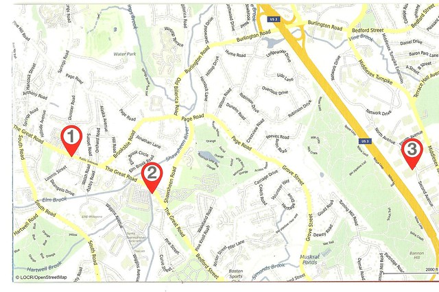
I recently received a brochure from my on-line bank showing the location of their no-fee ATMs near my home. The attribution in the bottom left corner reads “LOCR/OpenStreetMap”

I found more information at [Locr selects OSM] (http://maps.locr.com/en/blog/blog-post/locr-selects-osm.html)

I was impressed.

Location: Bedford, Middlesex County, Massachusetts, 01730, United States

During our recent trip to Florence, a notoriously car-unfriendly city, I found this car park. I forgot to take a picture, but it obviously once was a paid car park that has been abandoned since. (By the authorities that is, not so much by the drivers.) The small building at the northern end looks like it might have served for the personnel and at the entrance and exit there are what looks like remains of lift gates that have been broken or sawn off. There are no blue signs with white “P” on them but there are no parking restrictions either. Many of the cars there were covered with a thick layer of dust, some had long (as in months) overdue parking tickets behind their wipers, others looked quite ordinary and came and went during our stay.
I asked some passers-by and all of them confirmed that it was ok to park there and that the locals regularly do so, only that we shouldn’t leave anything of value in the car. I left the car there and it was still there the next day, quite happy and unharmed.
Of course, I mapped the whole thing and proudly added a “fee=no”. The trouble is, technically it’s not an “amenity=parking” at all because it’s not designated as such on-site. “disused:amenity=parking” comes to mind but it’s not disused either, as people keep using it. “access=permissive” and possibly “access=discouraged” come close but not quite. So I added “informal=yes” like some footpaths have, although the car park certainly was “intentionally established” and didn’t just “evolve”, as the Wiki defines it. Actually, I’m pretty sure I know at least a few car parks where “informal=yes” would fit perfectly, but this isn’t one of them.
So, do we have a better way of dealing with this?

Location: 43.760, 11.272
Posted by PlaneMad on 5 April 2017 in English.

While reviewing edits in my neighbourhood, stumbled on a lot of edits by a new editor called StreetComplete. Streetcomplete seems like an open source map editor on Android to quickly add missing metadata to OSM around your location like streetnames, road surface opening hours etc. using a simple form based UI.

Github: https://github.com/westnordost/StreetComplete

Curious, I listed all the changesets from StreetComplete using osmcha and was surprised to find over 30,000 changesets since the first one in Nov 30 last year. Just yesterday, there was 2,700 changesets uploaded, so there seems to be a sudden surge in editing activity.

The edits in my city were mostly adding the road surface and looked quite good, and its exciting to see such well designed tools driving new contributors to the map. If you are curious use osmcha bbox filter to review edits from StreetComplete in your area and share any observations on the editing activity.

Posted by alexkemp on 4 April 2017 in English. Last updated on 4 July 2022.

Buildings in Gedling worth a second look:–
(see also Key:heritage + Key:listed_status + Key:HE_ref)

Gedling Borough Council claim 200 buildings to have been listed by Historic England within the area that they control, and offer a PDF to download with all such buildings listed by district (the PDF is based on information from a very old listing and not updated). There are just 7 listed for Gedling Village itself. Here are six that I mapped recently + an unlisted extra:–

Hardstaff Almshouses, Gedling

heritage=2
heritage:operator=he (“Historic England”)
listed_status=Grade II
HE_ref=1268312 (listing)
start_date=1935
name=The Mary Elizabeth Hardstaff Homes
wikipedia=en:Mary Hardstaff Homes
One of the ladies living here gave me the 3rd Degree interrogation, and with good reason. Many folks photograph these Almshouses on Arnold Lane due to their Grade II listing. The lady did not mind that, but she did mind folks that saw the photos then came round & nicked stuff from the gardens (there are many fine displays of gnomes & such-like in front of the homes). I was sorely tempted to picture some of them, but promised her that, on this occasion, I was photographing only the building:–

See full entry

Location: Gedling, Carlton, Gedling, Nottinghamshire, East Midlands, England, NG4 4BH, United Kingdom

The Open Source Routing Machine supports bearing constraints for quite a while now. In the following I want to highlight their use-cases and effects on routing.

Suppose you are driving north and make a routing request. An instruction to take a U-turn — since the routing engine does not know your heading — would be undesirable. This is the primary use-case for setting bearing constraints.

Setting a constraint of bearings=0,90 tells the routing engine you are heading north and you want to allow for a variation of +-90 degree around true north. The format is value, range with

  • value in 0, 360 degree for the direction; 0 degree represents true north, 90 represents east and so on
  • range in 0, 180 degree for the allowed variation around the value; a variation of 90 degree allows for +- 90 degree

The bearings=0,90 constraint therefore allows the route to start off towards north +- 90 degree. But not in the opposite direction you are currently heading. Sweet!

Another interesting use-case I came across at FOSSGIS is fire truck routing where your vehicles have to arrive at the right side of the street. Using bearing constraints not only for the route’s start but its end location we can let the routing engine generate optimal routes which guide vehicles to the right side of the street.

Here are two routes from a fire department in Berlin to an arbitrarily chosen location:

  • In orange with a bearing constraint of 0,90 guiding the fire trucks to the location from the northern direction (raw request)
  • In green with a bearing constraint of 180,90 guiding the fire trucks to the location from the southern direction (raw request)

See full entry

Posted by SimonPoole on 4 April 2017 in English.

Now despite the difficulties of garnering attention when your app doesn’t break things, Vespucci development has carried on and I’m pleased to announce that the first “official” beta release of 0.9.9 is available from googles play store and from our [github repository] (https://github.com/MarcusWolschon/osmeditor4android/releases).

While there are quite a few user visible changes, most of the work since the release of 0.9.8 has been under the hood, improving the maintainability, testing, documentation and code quality throughout the app, making it much easier to contribute to its development.

It should however be noted that Vespucci has a relatively large code base and contributing to the code (but not to the documentation, presets and other aspects of the app) remains fairly complex. See vespucci on OpenHub for more on that.

The release notes give an overview of what has changed, here just some highlights:

See full entry

Posted by PlaneMad on 3 April 2017 in English.

On an average, there are atleast 40 data reverts per day. Most changesets comments are non descriptive like revert previous change making it very hard for the community to track the action and any previous changeset or discussion.

It would be really useful if OSM implemented a changeset mention feature like GitHub, where if I fixed a changeset with a comment Remove duplicate features added in #47398827, it would automatically add a comment to the original changeset and notify the original mapper and anyone in the community know what action was taken. This would greatly improve the social aspect of mapping and link discussions over multiple changesets.

Any other cases where this could be useful?

Posted by apm-wa on 2 April 2017 in English.

I traveled with the rest of the diplomatic corps to the new potash mine and processing plant near Garlyk, Lebap welayat. Used the Garmin GPS to collect railroad GPS traces to the last station, then Pocket Earth on my iPhone to collect GPS traces of the new road paved from there to the plant. Uploaded all traces yesterday and corrected the rail route, then added a new section of road. The GPS function on the iPhone drains the battery quickly so I used a backup battery nearly the entire trip. The rail car had a 220-volt outlet so I could keep the Garmin GPS charged. The traces are public so anybody can see/use them.

Location: Köýtendag District, Lebap Region, Turkmenistan