Adana 2024 To do:
- Fix some old blocks. – Done
- Update South Mahfesığmaz – Done
- Map Huzurevleri (Done), Yüzüncüyıl – PARTIAL
- Add buildings for Toros, Mahfesığmaz and Yurt
- Improve highways
I know that Nodes means something else in OSM but still trying to come up with a better term for what I have started considering nodes - namely areas that are a bit ambiguous in terms of what street they are ‘on’ because they are large enough to envelop or border a few different ones, and / or just very large parks, complexes, etc. that deserve their own dedicated exploration. One of these such not-nodes that we mapped today was St Luke’s Hospital / medical complex. We mainly walked around the outside and a few of the front entryways, mapping items like benches, trash cans, bicycle parking, art / memorial plaques, cameras, two mail drop boxes, one bus stop, and the chapel.
I was particularly interested to find a small sitting area with sculptures and memorial plaques which I hadn’t expected to see. I do have one annoyance with OSM, which I hope I can discover how to improve at some point: when I add a memorial plaque, I get a “fixme” telling me that it should be merged with a nearby building. Worse, some of the plaques that happened to be close enough to the building automatically merged with it. The problem is, these plaques were actually attached to freestanding sculptures in a courtyard / outdoor seating area and were not mounted on the building at all. One was free-standing next to a memorial tree that had been planted. I am not sure if there is a way to merge them with a sculpture, and for the ones that auto-attached to the building I could not figure out how to un-attach them.
Another node-like object that we looked at was a small cul-de-sac called Pearl street, that runs north-south for just a few blocks perpendicular to 43rd, near Sway coffee. We took the opportunity to return to Sway, this time driving instead of walking, and realized the parking (other than 5-minute spaces for folks getting takeout) was very limited. Pearl was mostly residential but had one church.
Dear OSM Bangladesh Voting Members,
The elected Election Commission has announced the exciting news about the upcoming OSM Bangladesh Election 2024! Since the formalization of our official structure in February 2023, we’ve witnessed incredible growth and collaboration within our community.
Nomination Submission Period: Jan 05-12, 2024
Nomination Verification: January13-14, 2024
Nomination Announcement: January 15, 2024
Nomination Withdraw Final Date: January 17, 2024
Candidate Campaign: January 18-25, 2024
Manifesto Presentation and Q&A Session: January 20, 2024
Election Day: January 26, 2024
Results Announcement: January 26, 2024
The nomination period is now open! We invite dedicated individuals and passionate voting members about contributing to the OpenStreetMap Bangladesh community to submit their nominations.
Engage in community meetings and campaigns where voting members discuss and deliberate on candidates’ contributions, visions, and goals.
Cast your votes on the specified date to elect the representatives who will shape the future of OpenStreetMap Bangladesh.
Here is the Election RULES & REGULATIONS
Fill out the nomination form with your details. Share your vision for OpenStreetMap Bangladesh.
Submit your nomination through NOMINATION SUBMIT FORM
Participate actively in the upcoming election process to help shape the future of our community. Your involvement is crucial in building a stronger, more vibrant OpenStreetMap Bangladesh.
Let’s make this election a testament to the collaborative spirit and dedication within our community. Together, we can continue to map a better future for OpenStreetMap Bangladesh.
If you have any queries, reach the Chair of EC +8801713120157 (Whats app text only) azizulalamtoton@gmail.com (Email)
Well this is interesting. I’m curious..
Sometime ago in 2019, out of curiosity I asked a friend who was a community engagement person to explain her job to me. What exactly is the role of a “community engagement person?”. Could it be just another title for a social media manager, or content creator?
Well, my friend loved her job and her explanation was plenty, but let me break it down and explain the role of community engagement.
I have come to the conclusion that some job titles can be used interchangeably, like Software Developer and Software Engineer. Whichever title you choose to have on your profile, the responsibility is the same. I feel, most companies use either for what suits their brand archetype.
The Municipality of Crowsnest Pass is bounded on the west by the BC/AB boarder and on the east by the municipal district of Pincher Creek.
Alberta Highway 3 passes through this municipality.
My edits in Changeset: 145865015 are as follows.
highway=trunk to highway=primary
From the Canada Tagging Guidelines for Primary Roads primary roads are typically 2-lane, undivided, provincial highways. This description is accurate for Highway 3 through the Crowsnest Pass.
See also the Alberta Highway Classification Guidelines
highway=trunk, however, is suggested for “the national highway system”.
Contrary to my change, the National Highway System page on Wikipedia lists Highway 3 as a core road in the national highway system. This may need reversion.
name=20 Avenue and nat_name:en=Crowsnest Highway
Within the Municipality of the Crowsnest Pass, Highway 3 is labelled on street signs as 20 Avenue. This is similar to how Highway 1 is also 16 Avenue through the City of Calgary.
The Canada Tagging Guidelines for Named Major Highways explains that when a named highway also has a street name, tag:name should be used for the street name and tag:nat_name should be used for the highway name.
maxspeed
I have personally surveyed the speed zone changes.
The Municipality of Crowsnest Pass also posted a map of speed zone changes that took place in 2019
I’ve created a changeset which fixes 117 links to Wikipedia disambiguation pages on segments of I-15 in Utah as identified by https://matkoniecz.github.io/OSM-wikipedia-tag-validator-reports/Utah,%20USA.html
In a nutshell, this change updates the wikipedia tag value, changing it from a disambiguation page to a specific article:
Old Link: https://en.wikipedia.org/wiki/Veterans_Memorial_Highway
New Link: https://en.wikipedia.org/wiki/en:Interstate%2015%20in%20Utah
This work is part of a larger MapRoulette challenge, https://maproulette.org/browse/challenges/40609, created by osm.org/user/Mateusz%20Konieczny to address problems with Wikipedia links in OSM data.
Rather than completing 117 separate MapRoulette tasks I downloaded JSOM data using the following Overpass API query and performed a bulk edit.
[out:xml][timeout:90][bbox:{{bbox}}];
(
way["wikipedia"="en:Veterans Memorial Highway"];
);
(._;>;);
out meta;
As this is my first large-scale edit I have tagged the change as needing a review –I will also ping matkoniecz so that the validator report summary page can be updated.
Welcome to the summary of work done in the fourth year of Divide and map. Now. – the damn project that helps mappers by dividing a big area into smaller squares that people can map together.
Four years ago, the damn project was developed to constructively criticize the HOT Tasking Manager. (HOT stands for the Humanitarian OpenStreetMap Team.) I see that the limitations of the HOT Tasking Manager persist, that it is not getting better, and that the developers of the HOT Tasking Manager can still benefit from constructive criticism.
In this diary, I will first recap the functionality and scope of the damn project. Then I will write about the work in 2023 and the work for 2024.
To understand the damn project, let us break it down into four main components, each of which has its own repository: the server, the web clients, the JOSM damn plugin, and the deployment guide. The deployment (for sysadmins) brings up the damn project. The damn server (for backend developers) contains the core service – JSON API to the PostGIS database. The JOSM damn plugin connects to the damn server so that mappers do not have to open the web browser to contribute to OpenStreetMap when using the damn project. Finally, the web clients repository (for frontend developers) contains the code base for multiple web clients.
The features available to mappers are divided into the JOSM damn plugin and the web clients, as the damn project serves multiple groups of mappers and recognizes these groups.
I have the suspicion that my phone is tagging the GPS location for some photos rather wrongly (timed offset is my guess). Found this out when comparing the locations against those indicated on JOSM photo overlay.
This despite the phone getting both L1 and L5 signals, and running with no sim card which should reduce cpu load further since there’s not much background processes that need to be handled.
To say I’m pissed is rather an understatement. Moving on, I will try leaving the phone to only record gps track and then matching photos from my cameras to that. No electronic shutter so extra wear and tear on that mechanical one! Shoulda bought that oly em10 back then.
I completed my first 100+ physical addressing on Magnolia Ave., Birch Run Ave., Redwood Rd., Hickory Rd., Elder Pl., Hemlock Dr., and Beech Pl. The project took about 3+ hours to complete. I’m new but will soon get into other tasks. ChangesetID: osm.org/changeset/145716852
addr:city=Denville
addr:postcode=07834
addr:state=New Jersey
addr:street=
addr:housenumber=
I got my husband to join me and help me with mapping today. We went from approx. State Line Road in KC on 43rd St (we think of it as 43rd though there is a stretch that’s Westport Rd) and down to the west end of it just beyond Mission.
We went to Sway Coffee Roasters and had a nice cup of coffee/tea, and got to say hello to some sweet dogs that another customer brought with them. The dogs visited everyone within leash distance and everyone seemed happy to see them. Little random encounters are what make me love the city so much.
My plan next is to visit the stretch of 43rd east of Gillham Park, and to touch some of the “nodes” I skipped over when going along the length of it, like St Luke’s and various parks etc.
QPFF+F9R, QPFF+CFR, Grand Trunk Rd, Wah, Cantt, Rawalpindi, Punjab 4700, Pakistan
Satellite Town is the Controlled Area near by GT road and Basti Lalarukh wah cantt. A ghost Town in triangle shape with the flavor of dead end.
It was fun editing Leboya bay, it was missing some information and buildings. We went for three days camping and I had fun surveying the area and discovering what the camping site had to offer.
Based on a coincidence, I used Overpass in my area to try to identify objects marked for removal that are older than period X. Unfortunately, I didn’t manage it so easily and at the same time had the idea whether it wouldn’t be better to check this on site via street complete. In the course of the GitHub issue, however, it turned out that it doesn’t really fit the core of Street Complete.
So back to Overpass and the good old query in advance to be able to check it later on site. With the help of other OSM users on Telegram, the following query was created, which can be easily customized:
https://overpass-turbo.eu/s/1Fml
To be on the safe side, the overpass query is shown here as code:
//Check for Stages of decay
//based on the idea of:
//https://github.com/streetcomplete/StreetComplete/issues/5402
[out:json][bbox:{{bbox}}][timeout:800];
//gather informations about non-excisiting objects
//and store the data as "gone"
(
nw[~"^demolished:.*$"~"."];
nw[~"^razed:.*$"~"."];
nw[~"^removed:.*$"~"."];
nw[~"^destroyed:.*$"~"."];
)->.gone;
//substract any gone-object, that was last modified
//within the last X years
(.gone; - nwr.gone(newer:"{{date:1year}}"););
out geom;
Start time: 6:42pm End time: 7:49pm

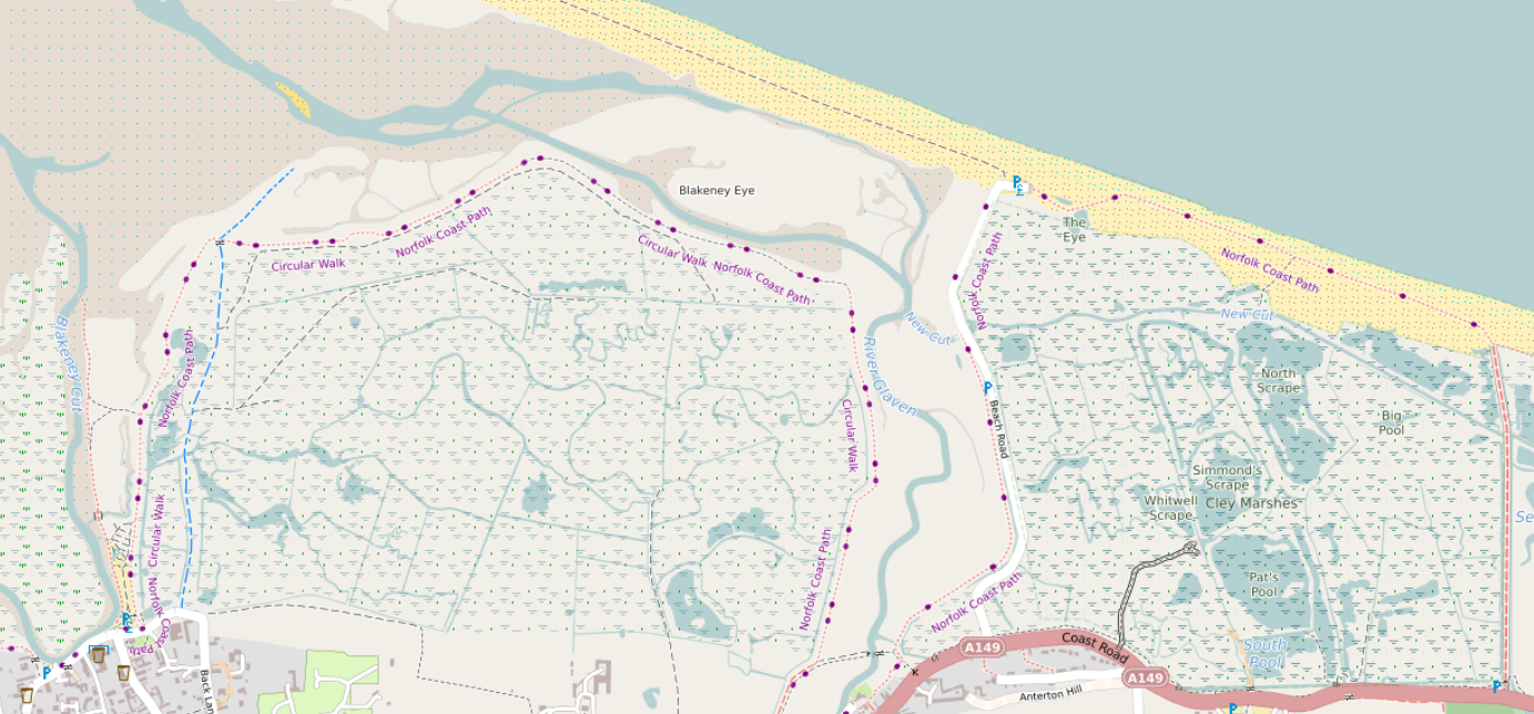
A major rewrite here takes into account tags such as natural, reef, wetland, surface and tidal before deciding how to show wetland areas. See the picture above, which is here, and here in OSM.
The beach between high and low tide can be clearly seen here (in OSM, here). There are blue dots in the sand rather than black. A deliberate decision was taken to show more detail for areas above low tide. See e.g. here between Wales and the Wirral (see here in OSM).
Over the last few days I have been chipping away at validating tasks for the #osmIRL_buildings project.
I have now just finished validating all of Howth. There is still a good bit left in the rest of the county, some of it will definitely be quick due to some areas being rather rural.