Diary Entries in English

Recent diary entries

Posted by b-unicycling on 18 June 2023 in English.

This weekend, I attended the 2023 OHNI Conference, OHNI standing for Oral History Network Ireland. The overall topic was “Power & Resistance”. I had heard about them at a training seminar for Heritage Week where I went in preparation for my events about milk churn stands. I had 4 days before the deadline to hand in an abstract, but I went for it! I was granted a slot in the “moments” section where people get 10 mins to present their project.

My reasoning for participating was to spread the word about OpenStreetMap which seems to be very little known in academia and maybe especially the humanities, as well as local authorities. I did not know how well attended this conference would be, but every little helps.

I decided to talk about the possibility of mapping place names like field names, because that could be considered oral history and because I expected most attendees to be Irish and to know about field names. I was trying to make OSM as relatable as possible.

See full entry

Posted by NorthCrab on 18 June 2023 in English. Last updated on 11 August 2023.

Greetings OpenStreetMap community,

Following the release of osm-revert, I’m here to share details about my new project, OSM Relatify. This tool is designed to simplify the process of editing public transport relations within OpenStreetMap (OSM).

Application preview

OSM Relatify is built with the goal of making public transport mapping more accessible and efficient. While it currently focuses on bus relations, the vision for OSM Relatify is to encompass a broader range of public transport mapping tasks.

One of the key features of OSM Relatify is its smart routing logic. It automatically constructs bus routes from given bus stops and ways, taking into account factors like one-way streets and roundabouts. This significantly reduces the time and complexity involved in managing bus relations, making the tool a valuable asset for both new mappers and seasoned contributors.

See full entry

Posted by Longhorn256 on 15 June 2023 in English.

Along Pennsylvania’s freeways, there are emergency detour routes that allows travelers to bypass traffic accidents, inclement weather, and other road closures. Colors commonly used are black, blue, green, orange, and red. The detours are perhaps one of the least mapped features across Pennsylvania.

The best sources to consult are street-level photos from Mapillary and Bing Maps to establish which highways the particular route follows. I also recommend having a map nearby and to use colored pencils to mark the detour on the map.

Tagging the colored detours is quite easy using iD. Simply create a new Relation -> Route Features -> Detour Route.

Under Name, type in the name to be used, for example Orange Detour (I 79 Exits 121-130). Colors are used multiple times, so it is necessary to differentiate between them by including the ref for the highway being detoured and also the exit numbers that are being bypassed.

The Route Number in this case is Orange.

Because these detours are bidirectional, the from and to tags aren’t necessary.

The Colour tag would be orange.

Since I-79 is being detoured in this example, the Detour tag would be I 79.

Don’t forget to tag the directional role of the relation if the road being tagged is one way.

To make tagging easier, consult the OSM Wiki under the Detour page.

I have also published a YouTube video showing the best way of how to tag the relation.

I hope y’all find the resources helpful for adding the emergency detour routes across Pennsylvania.

Cross-posting from HOTOSM blog.

As we dive into the second half of 2023, we are thrilled to share the progress made by HOT and the Community Team in leveraging OSM data for informed decision making.

Hello! I’m Rubén Martín, HOT’s Community Strategist and Research Lead, and in this post, I aim to highlight our recent achievements and extend an invitation to OSM communities, contributors, organizations, and individuals interested in OSM data to collaborate with us on analysis and research endeavors.

Focusing on Actionable Insights: A Data-Driven Approach

At HOT, our data approach goes beyond satisfying curiosity; we strive to generate actionable insights that enable us to better support the communities utilizing Open Mapping to address local needs. Over the past months we have, together with our dedicated Data and Analysis Intern, Caleb Fagunloye (along with support from Benni Herfort at HeiGIT) made significant progress in two key areas outlined below:

  • Better understand OSM Contributor Data and validate assumptions around contributors decline.

  • Explore and experiment how to make OSM Data more accessible to non-technical people.

OSM Contributions Decline

See full entry

Making plans, so checking on the many sources for good hikes in an area. First, because it’s Six Rivers National Forest (mainly), I glance over the Forest Service topographic maps. There’s not a lot of trails showing on there in the area, but there’s three heading up to a selection of lookouts. There’s also a bunch of quarter mile spurs. Why? What sense do these make?

I check the USGS, but these are generally older and the information was supplied by the Forest Service anyway.

For the basic well known things, check AllTrails. It says you can cross country up Black Lassic. (I knew that already.) A community content tab appeared a few years back and you can find some good things here sometimes, but it’s always buried in a load of strange. There’s a bunch of strange in this area. Strange strange. Usually there’s a lot of long bike rides, but not here. Someone has apparently hiked the river underneath the reservoir. That’s fancy.

Hiking Project will often have a different set of trails. Actually, I find this a much more useable app for finding trails. Some of that is because even the free version will let you easily have the whole state downloaded. (It’s funding by outdoor venders and if they encourage you to wear out your gear, you’ll buy more gear.) Unfortunately it only has the nearby National Recreation Trail I already know about.

See full entry

Location: Trinity County, California, United States

A virtual discussion on the subject “Structure and Governance of a Local OSM Community” held on March 23, 2023 was the third of the Humanitarian OpenStreetMap Team (HOT) Community Working Group Peer-to-Peer Learning Series aimed at supporting the new OSM chapters in Saint Lucia and Dominica. This session was attended by 18 members of the OSM Community from across the globe. The session was guided by some key questions on the subject; below are the major take-aways from this discussion.

What are the different roles that people can play in a local OpenStreetMap community?

The roles and responsibilities were discussed as a precursor to the discussion on the structure. It is important to identify what the community should consist of ahead of assessing how it is organized. The most common roles highlighted were mapper and trainer. However, roles such as sponsor, social media marketer, community coordinator, communications and project manager. Communications include posting on social media, blogs and even responding to questions on the forum.

See full entry

Last week, the climate officer from my local county council reached out to me to see whether “we” (i.e. OSM) had locations for drinking_water:refill mapped. (She used to be the heritage officer, so she knows well what I do).

After some confusion about what she meant (I thought holy wells…), I found that there was one mapped as amenity=drinking_water, but without the drinking_water:refill tag.

I presume the reason she is asking is that the council wants to install more, but doesn’t know where there are already some.

Some more research revealed that there are at least two providers in Ireland, both use GoogleMaps, one not very successfully: EcoFil. In agreement with the OpenStreetMap Ireland board, I sent emails to both companies to ask whether they could make their datasets open giving the county council analysis as one example for the usefulness of #OpenData in this case, pointing out that they could also benefit from a complete dataset.

(overpass-turbo for Republic of Ireland)

Refill Ireland sticker

See full entry

Posted by krschap on 8 June 2023 in English. Last updated on 15 June 2023.

Introduction

The purpose of this document is to explore the possibilities of the Segment Anything Model (SAM) Segment Anything developed by Meta in OpenStreetMap mapping. SAM is a promising model in the field of image segmentation, and its potential application to fAIr could enable the tracing of various features on maps. This document provides an overview of SAM’s working mechanism, test cases conducted with SAM, and two potential integration ideas for utilizing SAM

SAM Working Mechanism

SAM operates directly on images and generates individual masks based on the training datasets used during model training. Unlike object detection models, SAM focuses on segmenting all elements present in an image, regardless of their nature, based on texture, color, and points of difference from the background and several others can be found on their research doc SAM Working Mechanism

Advantages of SAM for fAIr and OSM Mapping

See full entry

Thanks to planetiler, it is possible to run your own OpenMapTiles vector tile server on Amazon Web Services (AWS) for less than $20 per month. This guide describes the process that I used to stand up tile.ourmap.us for the OSM Americana project, and it does require some knowledge of AWS. However, I taught myself how to use AWS, and I’ve tried to include enough details here to assist someone trying to stand up their own tileserver.

There are many different ways to do this, including different storage, hosting, and tileserver setups. This is just one option that worked for me for what I was trying to do.

The architecture

This setup in this guide assumes that infrequent planet updates is acceptable for your use case. So, we will spin up a powerful server to update the map only when needed, and use a low-powered server to run the HTTPS tile server on an ongoing basis. If you require more frequent map updates, this is probably not a good solution and you should consider dedicated hardware. The main advantage of AWS in this use case is the ability to rent a high-performance computer for a short period of time.

Additionally, this setup assumes that you already own a domain name that you can use to point to the tile server. If you don’t have one, you can purchase one on Google Domains for $12 per year.

In our setup, we will render a planet to a large file in .mbtiles format, and use tileserver-gl to serve that .mbtiles as an HTTPS server.

Another advantage of using AWS is that they host a locally-mirrored copy of the planet file. Therefore, it is posible to download the planet in a few minutes, which reduces the amount of time that we have to rent that high-powered server to render the planet.

When we say “render the planet,” it means the following operation:

See full entry

Posted by tregeagle on 7 June 2023 in English.

The startling regularity of these posts amazes even me. Today I went for a bit of a walk with my brother Joe’s dog, Pumpkin. It’s an embarrassing name. Joe and his kids seem to shorten it to Pumpki. My mouth and memory struggle with that so I have been trying Pumki, Pumpi and Punki. Pumpkin does not respond to anything I say so I have tended toward Dog or Hey You. I resorted to buying a packet of dog treats in a mildly successful effort to be noticed.

OSMAnd has been very handy as usual to find my way. I found a broken bit on the map and tried to fix it but I don’t really know what I’m doing. I did record my track, hopefully that’ll help someone.

Location: Wylam Wood, Wylam, Northumberland, North East, England, NE41 8HX, United Kingdom

For some months now, Champs-Libres has been working for the NMBS/SNCB, the national railway company of Belgium, for reusing OSM data of Belgian stations. The NMBS/SNCB has an interest in OSM data for improving some services to travelers regarding accessibility data, especially for bicycles. Have a look at the wiki page for more insights!

The first diary entry was about the basic data on the Belgian stations and platforms. In this second diary post, we’ll show how to map access to the railway platforms.

What is the access to a railway platform?

A traveler, with or without a bike, can walk to/leave a platform by several means of access. We’ll call these “access objects”, which can all be mapped in OSM. Here is how to map these access objects and how they are mapped in the Belgian train stations. We hereby focus on travelers walking through stations with their bikes.

Elevators

Elevators are represented in OSM with a single node (most of the time) and the tag highway=elevator. The following overpass query https://overpass-turbo.eu/s/1pm1 gives 90 elevators that are strictly to and from the platforms. They are mostly found in the larger train stations. However, we noticed that some elevators were not identified by this query because they were slightly outside of the platform area. This should be corrected in most cases.

See full entry

Location: 50.469, 4.862
Posted by Qwajo OSM on 6 June 2023 in English. Last updated on 20 June 2023.

As it stands, I believe the need to rekindle the interest in volunteerism among members of the open mapping community is a necessary evil. This belief results from personal experience as well as other colleagues’ experiences. I joined the open mapping community through Youthmappers in 2016 and have been actively involved since then. Mapping has been fun and competitive since I joined the community. Thus, at the local chapter level, national and international levels, I have enjoyed a series of mapathons that were fun and competitive. A major event I can recall is the Malaria mapping challenge, where mappers from the University of Cape Coast were rewarded with some GPS devices at the end of the challenge to boost their mapping activities. Memories from the challenge put smiles on my face to this day. I can recall that some members of UCC Youthmappers were happy to answer a midnight call, trade sleep, and map to contribute to the malaria challenge and help the chapter compete as well.

I take a closer look at some of the local chapters in my home country these days and that zeal and interest seems to be dying off. That is a worry that needs attention, especially from the Gurus in the community. We have to encourage old members to share the positive impacts and personal experiences they have had so far with members who are losing interest to revitalize their interests.

Also, competitions should be enrolled more often and at all levels to be sure no one is left out. Finally, all members contributing every bit of data should be given some recognition so everyone feels involved. Let us keep the community running and keep the volunteering spirit moving!

Location: Community 18, Sakumono, Tema West Municipal District, Greater Accra Region, Ghana
Posted by spughetti on 6 June 2023 in English. Last updated on 7 September 2023.

Introduction

About 2 weeks ago I found San Francisco’s open data website, on it was this dataset containing 70 murals along with information about their artist and Cultural District. I used SF Mural Arts as a source for the names of some of the murals.

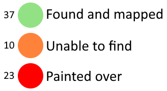
I’ve uploaded all the files I used for this project here. I used a spreadsheet to track my progress, the file is called “StreetSmArts_Murals_progress.ods”. You can find way IDs in column Q and notes in column S. This legend explains what each colour used in the spreadsheet means and how many murals belong in each category. Legend to explain each of the colours used in the spreadsheet along with how many murals belong to each category. Green (37 murals) means found and mapped, orange (10 murals) means unable to find and red (23 murals) means the mural was painted over. If you are unable to see this legend you may be looking at an archive of this diary entry, please go to https://ia902608.us.archive.org/24/items/Importing-StreetSmArts-Murals-in-San-Francisco/legend.png to find the image.

Tagging Schemes

There weren’t any tags for some of the information in this dataset so I came up with some new tags in the process.

Cultural Districts

Some of these murals are within certain Cultural Districts, which from what I’ve read on their websites are basically just a fancier version of neighborhoods that organize events to celebrate the culture of those within the district.

See full entry

Location: Civic Center, Tenderloin, Mission, San Francisco, California, 94102, United States

Hello!

I’ll be working on developing Python bindings for the OSRM project for GSoC this year.

I’m pretty excited to say the least, as mapping/navigational data is something that I find genuinely fascinating and important, but also because I’ll be able to learn about working on a project via hands-on experience - with guidance from some really nice mentors.

A little bit about me - I’m most comfortable writing C++ code, as it’s the language I have used the most by far. That said, I’m also interested in all things development related, so it’ll be a good opportunity for me to learn more about bindings and the Python side of things.

Posted by JM-Lemmi on 5 June 2023 in English.

Mapping the Weinsberger Berge

Inspired by Tom7 to go outside more, I set myself the goal of biking every Forestpath between Weinsberg and Heilbronn, before I will be moving avay in the Summer.

In the process I stumbled across many Tracks that need updating. Many have overgrown to the point of unusability, others are not mapped yet. One of the biggest challenges for the Forest in my opinion is deciding which Harvester Tracks should be mapped and which not. On a normal Field you wouldnt map every Tracktor Track, but in the Forest these Paths sometimes turn into paths used by the public. They are pretty volatile though. In the tree felling season they look like high traffic Tracks, very compacted, traversible by normal Trucks. But they are also not maintained, so quick to overgrow and turn very muddy to barely passable with a bike after a few days of rain.

This weekend I was able to complete the 4th of my areas and I wanted to take stock. I have driven every Path between Donnbronner Landstraße, Heilbronn and L1111. This includes the Schweinsberg, the vineyards, Köpfertal and Büchelberg. I also drove every path in Weinsberger Tal and the Waldheide between Donnbronner Landstraße, A81 and the Verwaltungsgrenze Weinsberg in the South.

See full entry

Location: Kernstadt, Heilbronn, Baden-Württemberg, Germany