Diary Entries in English

Recent diary entries

In this blog post, I am highlighting the significant contributions of the local chapters of YouthMappers in the OSM-Philippines community in 2022 and sharing a short reflection about the impacts of YouthMappers in a local context.

I want to start with this statement from Dr. Patricia Solis: “OpenStreetMap (OSM) community is a community of communities.” It captures the fact that OSM is more than just an online community; some diverse mappers contribute to the growth of the community. Some humanitarian mappers contribute data from a humanitarian perspective, helping minimize the impacts of disasters. Some hobbyists have been contributing particular knowledge all over the world for years. And now, corporate actors like Meta/Mapillary, Apple Maps, and Grab are contributing data concerning their corporate interests and for different use cases. Plus, there are local communities all around the world and also the local chapters of YouthMappers. It’s really impressive how OSM is a representation of different communities on the map. 🗺️

YouthMappers is one community that supports and makes up the OSM community. YouthMappers is an international consortium of university-level student mapping clubs with local chapters in universities of various countries. We leverage open data and open mapping such as OpenStreetMap to solve the development needs of the communities.

As young mappers, our goal is not just to build maps but to build mappers. We strongly believe that building the capacity of our mappers could forge collaboration among the communities and encourage the creation of more maps that could benefit the community. 💪

Based on the statistics last August 2022 provided by Jennings Anderson and Dr. Patricia Solis at State of the Map in Florence, Italy, YouthMappers has 324 university chapters on different campuses in 67 countries, and we are proud to say that most of our members are 45% women. 👏


See full entry

Posted by Filip009 on 24 December 2022 in English.

Why are we using duplicates in name tag?

(Maybe because it is hard to see difference between more similar relation at one place. So when you see relations in editors, you mostly see name tag or ref tag when there is no name)

  • route=railway

osm.wiki/Tag:route%3Drailway

(mandatory)

In this relation name tag should consist of:

“operator” “ref” “from” - “to”

  • route=train

osm.wiki/Tag:route%3Dtrain

(recommended)

In this relation name tag should consist of:

“vehicle type” “ref”: “from” => “to”

  • route=hiking/cycling

osm.org/relation/6177257

In this relation name tag consist of:

European long distance path “ref” - “description/note”

##

Mar 28, 2020 at 1:18 PM Richard Fairhurst

Let’s use the name= tag in route relations for route names. Let’s use the ref= tag for route numbers. If it doesn’t have a name, it shouldn’t have a name= tag.

osm.wiki/Talk:Tag:route%3Drailway

https://www.mail-archive.com/tagging@openstreetmap.org/msg51508.html

A month ago, Pista ng Mapa (PnM) and State of the Map Asia 2022 (SotMA) was held in Legazpi City, Albay. It was the first time we organized a face-to-face conference since the pandemic. For the past two years, we have been conducting Pista ng Mapa online since it was impossible to arrange an in-person conference given the risks of the pandemic.

PnM x SotMA 2022 Main Image

It is with no doubt that the participants had loads of fun, and the memories still linger on. But what are the secrets behind the success of Pista ng Mapa and State of the Map Asia 2022?

Joining the core organizing team - why and how?

See full entry

Posted by InfosReseaux on 23 December 2022 in English.

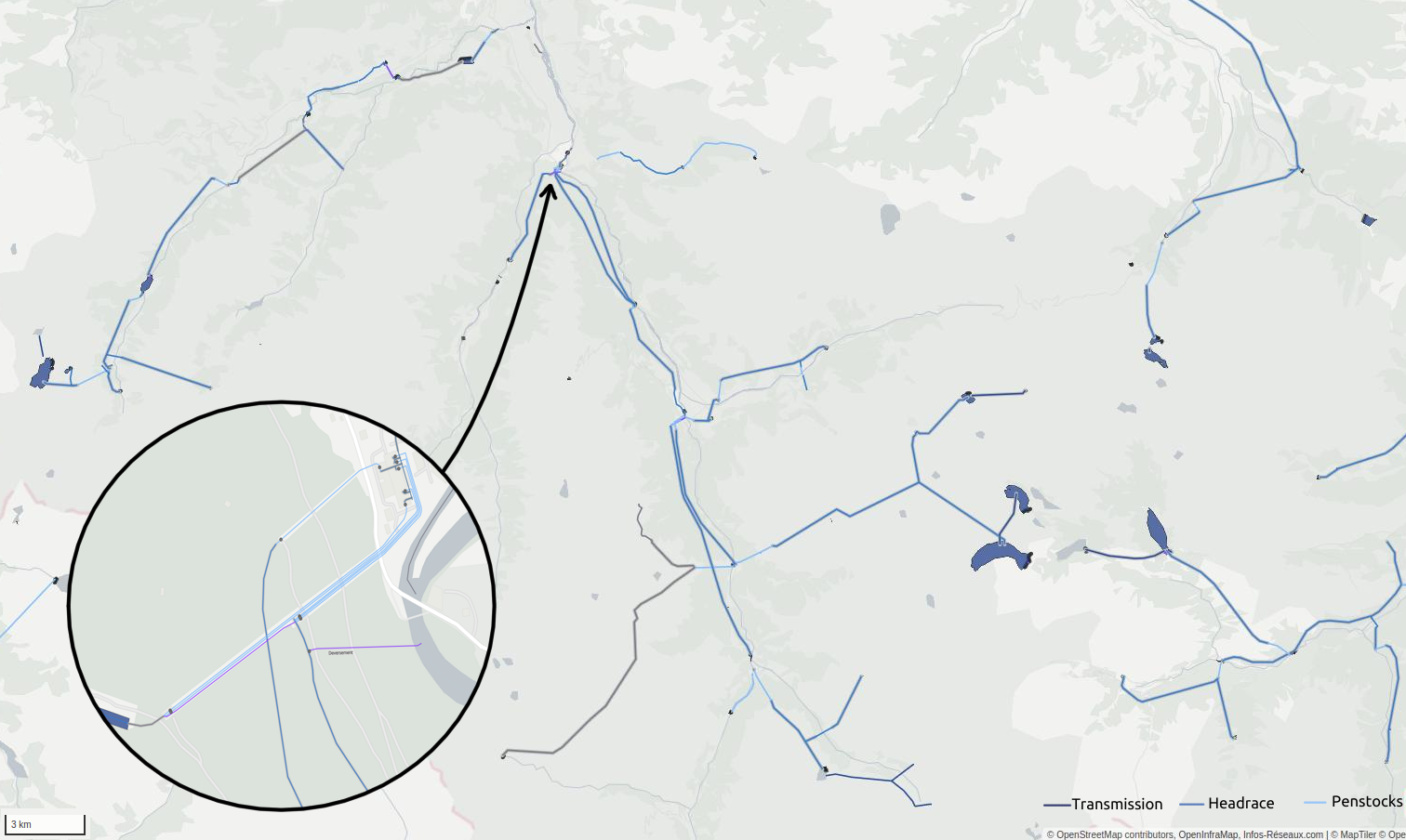
Hydropower mapping and render in French Pyrénées mountains

Water management and power infrastructure had made me busy here for years. Hydropower infrastructure intersects them both.

A new wikipage has been published about that (and waits to be improved) : osm.wiki/Power_generation/Hydropower

It’s not only about dams, power houses but about waterways as well, and OSM tagging model has been continuously developing to describe this. Water management will be more and more important in coming years to tackle droughts and fair water access challenges. Constantly seeking new ways to produce power and store water require accurate data and objectivity.

As hydro mapping and tagging improves on every continent, a more robust documentation on that particular topic may now be useful.

You will probably read it as a complement of existing waterways and water management pages.

See full entry

Years ago, in 2018 specifically, I was introduced to Open Street Map. As a then-Human Resource Assistant, I was in-charge in monitoring the locations of our sales personnel working on the field through the GPS application installed in their mobile phones. But at that time, I had no clue what this is, so, dare I say, I hated using OSM. So, I then ask the developer if I can use Google Maps/Satellite instead. And my wish was granted.

Then in 2020, I joined my current organization where I was introduced to GIS and QGIS. I forgot if it was during my first introduction to GIS or another occasion that reintroduced me to OSM. And my reaction was “Eeek, no.” Thus, the tale of “I Hate OSM” continues since I’ve barely used OSM whenever I create a map.

I never thought about that until now. Until the very second, I decide on this diary’s story of how life is a funny yet wise entity. How it gave me the understanding I lacked 4 years ago and offered me an opportunity to explore more about OSM. And this enlightenment would never have happened if it wasn’t for my GIS sensei, Ferdinand Dailisan, and the Pista ng Mapa X State of the Map 2022 organizers. You see without Sir Ferdinand informing me about PNMxSOTMA2022 and the organizer’s generosity to grant me as one of their travel fund grantees, I would not be here. I won’t be at the conference where my metamorphosis began.

During my whole PNMxSOTMA2022 experience, I got three E’s: experience, enjoyment, and enlightenment.

See full entry

Location: Em's Barrio East, Legazpi, Albay, Bicol Region, 4500, Philippines
Posted by b-unicycling on 21 December 2022 in English.

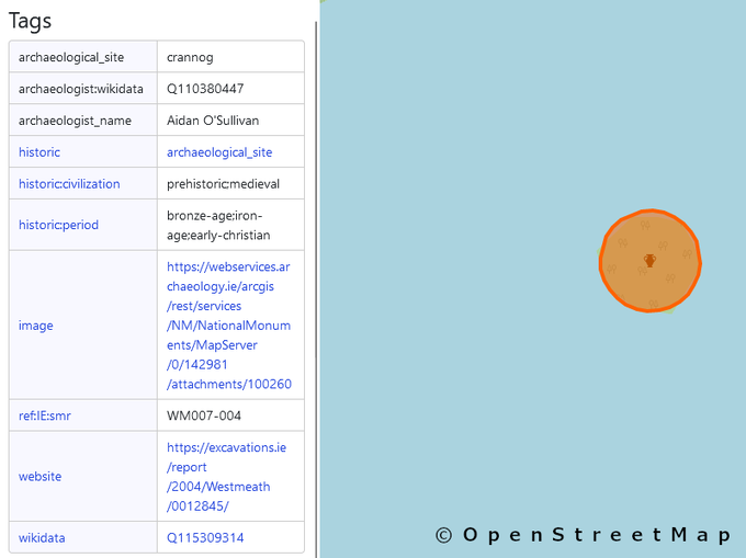
What do people think about adding archaeologist_name and archaeologist:wikidata to archaeological sites that have been excavated? It is very niche, I know, but it would help find literature about the excavation, once you have the name of the site director and the location, it should be possible to find literature associated.

It would be very similar to what we do with artwork and associating the artist with it.

I’ve started doing it, but only for two sites so far (1 and 2), because I happened to know who excavated there and because they have wikidata entries.

It would be a great job for all the Time Team fans out there! #justsaying

And I’m not trying to make OSM into a history map, in my defence; I still map a lot of contemporary things.

Location: Coolure ED, The Municipal District of Mullingar — Kinnegad, County Westmeath, Leinster, Ireland
Posted by frozenrabi on 21 December 2022 in English. Last updated on 13 January 2023.

It all started with a dream. A dreamer from Nepal once dreamt of visiting some foreign country and attending an international conference. After years of his contribution and devotion to open data and mapping, he finally gets the call for State of the Map, Italy but unfortunately, he couldn’t make his way to Firenze, Italy because he only received partial funding. He consoled himself that his time will come-may be not today but someday. Eventually, there was a call for sponsorship by Open Mapping Hub, Asia Pacific(OMHAP). The dreamer then waives new dream of fitting himself in for the STATE OF THE MAP 2022 Conference happening in Legazpi, Philippines.

“If you want something you never had, you must be willing to do something you’ve never done.” As the statement says, the boy was totally indulged in finding ways to attend the conference and was ready to give everything this time. He chose to digitize the projects launched by OMHAP. And he was willing to do something he had never done before. He usually mapped 2,000 buildings in a day when he wants to map more. But this time he mapped more than 8,000 buildings in a day which he had never done before. While looking back, he still doesn’t believe he had mapped 8k+ buildings but the stats do not lie. A week later, he received a confirmation that he is going to attend STATE OF THE MAP ASIA 2022 Conference. And also his two presentations were selected to present in the conference. He couldn’t believe this. His happiness knew no bounds and he can’t wait to share this with his family. And this happy, indefatigable guy was none other than Mr. Rabi Shrestha- sorry @frozenrabi- this is how OSM community knows me.

See full entry

Location: Yapatar, Paunauti-04, Paunauti, Kavrepalanchok, Bagamati Province, 45209, Nepal
Posted by Legitimater on 21 December 2022 in English. Last updated on 23 December 2022.

I’ve been mapping OpenStreetMap for approximately 9 months now, and for the 128 edits I’ve done (which 50% of it is mapping trees and farmland), I’m proud to introduce to you all my new operation.

The “Operation Green”. Which involve of me mapping farmland, trees, to make the map look more “greener” (more info here)

Changelogs:

  1. Mapping trees/farmlands, and other related nature features (Natural wood, etc.) will be now separated from other changesets
  2. A hashtag #OperationGreen will be now displayed on the comments in each changesets.

If someone see this diary entry, and you decide to do it also to make the map more greener as well, feel free! (P.S., Put the hashtag #OperationGreen on the changesets so I can know it came from me.

Thanks!

Posted by Letwin on 21 December 2022 in English.

2022 PART 01

#Welcome to OpenStreetMap Community

It was just 3 students, ambitious about a pathway they were not even so sure about. They accepted the challenge and got ready to roll.

So, we started our YouthMappers Chapter just as a Students OSM Community at our University. We didn’t know much but we were willing to take the risk. So, one thing we knew and we did was hold Africa Monthly Mapathons.

File:Launch3

This we knew and actually followed and for a time it was the only activity we knew. Fortunately for us, we had the unwavering support of our mentor Dr Prestige T Makanga and Dr Charles Paradzayi and of course Geoffrey Kateregga (our Mr OSM)! Later on, light came, and thanks to Regional Ambassador Laura Mugeha; we registered our small community as a YouthMappers Chapter and things started getting better and brighter. On this day, we launched our Chapter with an introduction to OpenStreetMap and YouthMappers.

See full entry

Posted by tffmh on 20 December 2022 in English.

Overview

Over the last year in context of Code for Niederrhein (CFN), especially the weekly online meetings, we have added the origin of the names of the streets in Moers to OSM. We added description, wikipedia- and wikidatalinks.

More than 1000 streets were processed.

The book “Moeser Straßen - Geschichte und Deutung - zum 700-jährigen Stadtjubiläum” (Moeser streets - history and interpretation - on the occasion of the 700th anniversary of the town) by Peter Hostermann, published by the town of Moers and made available online, was our main source. In addition to a comprehensive ethymological study, the book also contains the dates when the streets were named, in many cases the date of the town council decision that led to the naming. The book also lists renamings, so that we were able to include these for Moers if the course of the street remained identical or if an exact description of the old course of the street is documented.

In addition, the street index has been entered for many streets; here the work is not yet complete and will be pursued further.

Tags used:

  • name:etymology:wikidata
  • name:etymology:wikipedia
  • name:etymology:description
  • name:start_date (yyyy-mm-dd)
  • old_name: VON-BIS (yyyy)
  • de:strassenschluessel

Crew

  • black_bike
  • tffmh
  • Nastja G
  • noninc

Web

You can see the results at the following link (might take some more days until all data is up to date): https://etymology.dsantini.it/?lang=en-EN#6.633,51.46,13.3,type

“Moeser Straßen - Geschichte und Deutung - zum 700-jährigen Stadtjubiläum”: https://www.moers.de/system/files/2022-07/moerser_strassen.pdf

Code for Niederrhein: https://www.codeforniederrhein.de

OSM Project page: osm.wiki/Moers/Projekte/Stra%C3%9Fennamen

Findings

Some interesting take-aways from our work, with no claim to completeness, historical or other relevance.

General

A cadastral map existed from 1831, this being the first source of street names.

See full entry

Location: Moers-Mitte, Moers, Kreis Wesel, North Rhine-Westphalia, Germany

So, there’s this gem:

BLM track crossing Warren H. Brock Reservoir

This is the Warren H. Brock Reservoir overlayed with the BLM 356 track from the latest BLM GTLF data set. Construction started on the reservoir in 2008, so the BLM GTLF data in this area is at least that old.

Sometimes dealing with external data sources requires a little creative interpretation. Aerial imagery shows a track that goes around the reservoir, so that’s the new alignment for BLM 356.

Location: Imperial County, California, United States
First confession: I was supposed to write this weeks ago.

I had the perfect writing set-up on my rented Airbnb apartment: a cozy roof deck where I could be alone with my thoughts for hours and with an astonishing view of the world’s most perfect cone-shaped volcano: Mt. Mayon. And then, as with all other things, life happened and I am just publishing this one now. Even so, I believe that my attendance during the State of the Map Asia x Pista ng Mapa 2022 held last November 21-25, 2022 at Bicol University East Campus (fondly called by the locals as Buceng) in the lovely city of Legazpi, Albay still bears lessons and experiences worth sharing up until now.

Second confession: My knees were shaking the whole time I delivered my lightning talk.

My presentation on Mapping for Cultural Sustainability, a project I am pursuing with another She Leads and She Inspires (SLSI)^ champion from Nepal, was selected as one of the lightning talks for Day 1 of Pista ng Mapa. No matter how much I looked forward to all the things the conference was about to offer, the first day was nerve-wracking for a person like me who wasn’t that used to speaking in public, more so in front of 300 people who all have left their marks in the mapping community. There I was, a lone participant from Davao City (at least, that’s what I first thought) and a neophyte in the OSM community about to deliver her first public speech in years. Nevertheless, the purpose of my attendance pushed me to brave the stage and share my SLSI experience and the community project, a product of our six months of SLSI training, that I am working on.

See full entry

Posted by Anil Basnet on 19 December 2022 in English.

A ‘polling station’ or ‘voting center’ is a place where people vote, i.e. where ballots are cast. It can be a room in a building where voter registrations are checked, ballot papers are provided, and ballot box are available to put the ballot papers.

In Nepal, generally some rooms or blocks of schools and community buildings are used as the voting centers or polling stations for the purpose of voting in the election. While mapping a polling station in OpenStreetMap, we will add a node for a voting center and tag it.

Tagging Instructions:

Required Tags:

  • amenity=polling_station
  • polling_station=ballot_box

Naming Tags:

  • name=* (commonly used name of the voting center in native (Nepali) language)
  • name:ne=* (name of the voting center in Nepali language)
  • name:en=* (name of the voting center in English language)

Introduction

In the third week of October 2022, unfortunately, there was a big flooding event in Jembrana District Bali that caused several damages and casualties.

The Support

Right after the flood happened, Bali Disasater Management Agency (BPBD) contacted Open Mapping Hub Asia-Pacific (OMH AP) team to give some mapping support in some of the affected areas. Before OMH AP launched the tasking manager mapping to respond to the request, we conducted rapid data gap assessment through disaster ninja to see whether we still need remote mapping support or we can directly support them in the data utilization to create a flood impact map on that area. After we found that there were OSM data gaps on the affected areas, OMH AP created the Tasking Manager Project to support that event.

See full entry

Location: Mendoyo Dangin Tukad, Mendoyo, Jembrana, Bali, Lesser Sunda Islands, 82261, Indonesia

I’ve written a long blog post on sealed and unsealed roads in NSW. OpenStreetMap now has comprehensive coverage of road surface tags in NSW and the post provides lots of maps and tables to illustrate the patterns. Hope you enjoy it.

https://little-maps.com/2022/12/16/openstreetmap-now-has-comprehensive-data-on-sealed-and-unsealed-roads-across-new-south-wales-australia/

Posted by Kai Johnson on 15 December 2022 in English.

While I’ve been working on BLM Ground Transportation Linear Features (i.e. highways) in Imperial County, I took a small diversion to put in the BLM Off-Highway Vehicle Areas in California. Four of the major BLM OHV areas are in Imperial County, so it was relevant. These boundaries are important because many of the OHV areas are “open,” allowing cross-country travel off of designated roads and trails.

I’ve been working with the BLM CA Off Highway Vehicle Designations data set, which has 31 OHV areas in California and one OHV area from Nevada that slipped in because it’s managed by a BLM field office in California.

As I started adding the OHV areas, I noticed that almost all of these areas have never been mapped. Some of these areas are notable institutions in the off-road community, like Imperial Dunes (aka Glamis) and Johnson Valley (home of King of the Hammers). So adding these areas is a significant contribution to the map.

Tagging these areas is a little bit of a challenge. After some discussion with Minh Nguyen, I settled on landuse=recreation_ground and leisure=offroad_driving to tag all the OHV areas. The recreation_ground tag is a slightly odd fit but it seems close enough to be appropriate. And some renderers have an idea what to do with it.

Some of the OHV areas only permit vehicles on designated routes. That’s no problem because the access tags go on highway features and the OHV area doesn’t need any additional tagging. But many OHV areas permit open cross-country riding, so tagging vehicle access is an issue for these areas. I settled on adding motor_vehicle and ohv access tags directly to the areas, with values like yes for unrestricted access, permit where vehicles must have a pass, and permissive for the shared-use area of Johnson Valley which is periodically closed for military use (but not on a predetermined schedule).

See full entry

Location: Imperial County, California, United States

A few days ago I wrote about extracting GPX location data from the raw videos coming out of my A129 dashcam, and uploading to Mapillary. I was doing this one video at a time. A typical drive yields a lot of short videos, each 1, 5 or 10 minutes long depending on the settings. Some automation would be nice!

Mapper n76 suggested in the comments to my previous post to concatenate the short videos first and then process the resulting single video. I tried this following the instructions on the ffmpeg website, but I could not get exiftool to extract location data from the resulting longer video. So what I did instead was write a simple bash script that just loops over all MP4 files in the directory and does the GPX extraction and Mapillary processing / uploading for each file. Here’s the full script I used, which has the gpx.fmt file you need for exiftool baked in for convenience, but the loop itself is simply:

for f in *.MP4; do
    exiftool -m -p gpx.fmt -ee -ext mp4 -w %f.gpx $f
    mapillary_tools video_process_and_upload $f --geotag_source gpx --geotag_source_path ${f%%.*}.gpx --skip_process_errors
done

I found that I need --skip_process_errors because there’s usually one image extracted from the start or end of each video file that cannot be matched with a timestamp from the GPX file. I don’t care enough about one single image out of an entire sequence to try and figure out why, but I’m sure someone more determined than I could fix it :)

Location: East Liberty Park, Salt Lake City, Salt Lake County, Utah, 84105, United States