Diary Entries in English

Recent diary entries

Posted by Kento Kei on 5 March 2022 in English.

So currently I’ve been taking some time off from mapping due to the upcoming midterm assignments coming from school, so as the end of the 3rd quarter nears, I do have plans for what I will be doing next.

  1. Try to map buildings in areas with worse quality imagery, thus so when I get to better quality areas, progress would beable to be sped up.

  2. Map out the urban areas of the Metro East. By doing this It will give more incentive for me to 1. map, and 2. work in those regions more often

  3. Finally, I plan on beginning work on Alton hopefully by the end of the month, and if not then definitely before the summer.

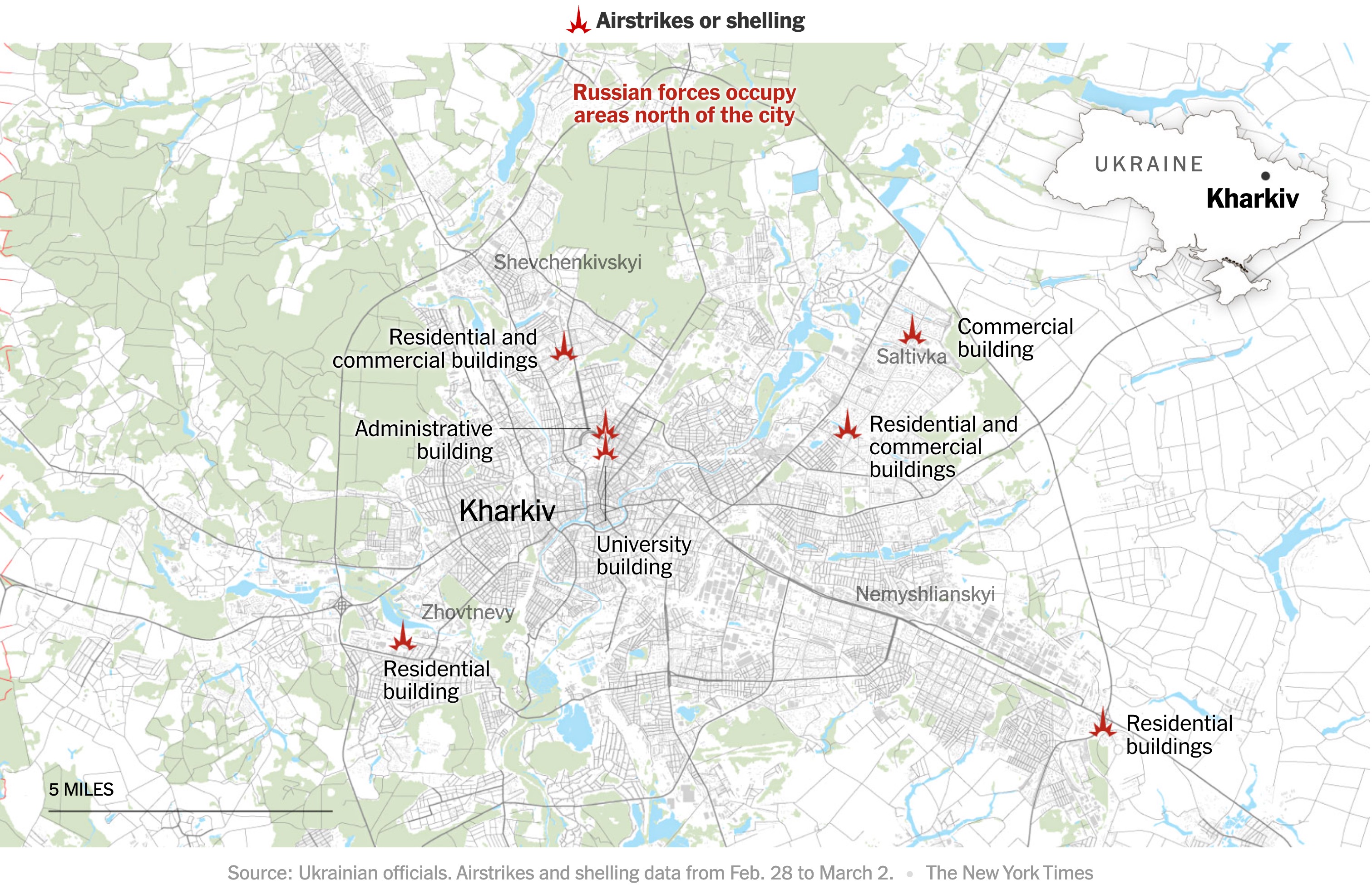
The New York Times has maps tracking the Russian invasion of Ukraine. I wondered what the data source of the first one was: were they maybe using OSM?

New York Times map of attacks on Kharkiv

Mappers on the #openstreetmap IRC channel quickly found some differences. Just to be absolutely sure, I used the QuickOSM plugin for QGIS to download OSM data for the area from overpass. I then quickly styled the map, using the colour picker to copy the Times map. In half an hour, I had my own map of Kharkiv.

See full entry

Location: Новобаварський район, Kharkiv, Kharkiv Urban Hromada, Kharkiv Raion, Kharkiv Oblast, Ukraine
Posted by KingVik on 1 March 2022 in English. Last updated on 2 May 2022.

UMN Nigeria Carried out online Webinar Training which last 3 times a week on how to use JOSM

JOSM is a free software desktop editing tool for OpenStreetMap geodata created in Java, The editing tool contains advanced features that are not present in OSM’s default online editor, iD. we train UMN Nigeria Members how to Use JOSM Ranging from how to Download it, Map using JOSM on Task Manager, Shortcuts, upload after digitizing, etc

Posted by bo_hot on 1 March 2022 in English.

Well, what a start to the year it’s been! Like mentioned previously, new directions, new collaborations and, I’m excited to announce, new team members!

While you can read the official bios for each new member linked by their name, I would like to take this opportunity to introduce them unofficially to everyone. Please see their unofficial bios and a quick insight into why I’m really glad to have them joining our team.

Leen D’hondt - Senior Product Development Manager

Leen’s unofficial intro
Leen is passionate about maps and how maps are used to create a ‘better’ world. She will co-drive the product strategy of the HOT Tech products so as to build tech products for the use cases our stakeholders care about most. 

 Leen is not only passionate about mapping and usage of maps. One of the things she loves is to spend time outdoors, especially in the mountains or at the beach. As a mother of two boys, she probably needs to start playing football ;-).

Bo’s intro
Leen is a perfect combination of strategy and action. On her first day, she was immediately asking the big questions of why are we doing this and then jumping straight into what we are doing and how. Pretty much the best first impression a PDM can make.

I am excited to have Leen on board, as she is an open minded active listener, which makes her perfect for this role. Not only does Leen have a wealth of experience in the OSM world (joining us from TomTom), but her commitment to understanding what is best for the team, while at the same time understanding how we serve the ‘greater good’ is something we will all benefit from personally and professionally.

Petya Kangalova - tech_collective facilitator

Petya’s unofficial intro
“I joined the HOT tech team in February 2022 as Tech Collective Facilitator, currently based in Bristol, UK. I am really passionate about the impact of open mapping and using technology as the enabler for people in supporting their communities.

See full entry

Location: Quartier Saint-Merri, 4th Arrondissement, Paris, Ile-de-France, Metropolitan France, 75004, France

I’m really bored. Sorry if I’m starting a post this way, but a lot of inexperienced people are working in the very crowded are of Mogadishu with the result to get an horrific outcome.

We worked for maybe a couple of months to draw roads, communication towers and buildings (sometimes counting their floors, when the satellite images allow us to do it).

They are (trying to) mapping buildings, for some HOT projects #mogadishu-swm where it’s supposed to be an urban project related to the waste collection. But, inexperienced users, not used to interpretate satellite images nor having some common sense (if you see a large road going straight, why make two 90° bends to put a totally displaced building?), are severely degraded the previous efforts to have a decently accurate map.

I don’t share any picture, but as just a few examples I’ll give you the coordinates.

These are buildings shifted many meters from the existing ones, with the roads deformed: 2.0441091, 45.3154313 2.03717, 45.3523181

Here you can see the masterpiece: 2.0439412, 45.35413 osm.org/go/yAR0QC5~F?m=

Here another very personal interpretation of wrecked buses mapped as buildings 2.0447408, 45.3558223

I was wondering: if someone have (and is still doing) to map buildings, it means someone else are going to use these data. Don’t they realize those contributions are horribles?

I’m not going to waste my time trying to fix that disaster, I’m now busy to fix a lot of landuse relation in DR Congo and Central African Republic damaged or erased by other HOT projects.

Alessandro a.k.a. UNGSC-DTLM-Ale_Zena a.k.a. Ale_Zena_IT

Location: Hawle Wadag District, Banaadir, Somalia

Today was all about Java Open Street Map (JOSM) training, i learnt on how to map tasks with JOSM for the first time and it was lit. I will like to appreciate Miss Chisom Okwuchi, Mr Daniel Kingsley and lastly our National Coordinator Mr Victor Sunday, for this interactive session. i will admit that mapping is fun, mapping is real, non fiction etc…

Location: Municipal Area Council, Federal Capital Territory, Nigeria
Posted by Heather Leson on 27 February 2022 in English. Last updated on 2 March 2022.

Like many open projects/communities/organizations, we are asking questions about how we better organize and engage. We are asking how to get more people involved in our efforts. This post is about seeking help from the community as we shift governance models in Humanitarian OpenStreetMap Team (HOT). (There is also an update about the Etiquette/Moderation guidelines (see below).)

The “Call to Action” in December 2021 noted the need across OSM’s communities to 1. shift etiquette/moderation (codes of conduct) and 2. adjust governance. In 2021, I participated in a effort to update etiquette and moderation in OSM/OSMF. This year I am leading efforts, as chair of the HOT’s Governance Working Group, to focus on revising HOT governance. As much as I have questions about OSMF and OSM organizational and membership work, this post and my diary entries on governance (going forward) will focus on HOT’s governance.

Both HOT and OMSF have board of directors. There are contributors, supporters, members, partners, and allies across both organizations and the wider community of communities. Humanitarian OpenStreetMap Team (HOT) has a Board of Directors and a Governance Working Group. Overall, getting involved as a volunteer in the organization change and leadership can be daunting. We want to open up and help be more diverse, equitable and inclusive in our governance - the people, the models and the overall way we work.

How you can help

The HOT Governance Working Group (GWG) is exploring how we can be more open, what changes do we need to our governance models and membership engagement. Our goal is to help more people shape our future and potentially be board members or take up other governance roles in the future. For example, the HOT GWG used to be a membership only group. We changed that. The HOT community and allies are most welcome to join us. This year we have some goals:

See full entry

Location: Cité, Geneva, 1204, Switzerland
Posted by Teeman on 26 February 2022 in English. Last updated on 27 February 2022.

I participated in this training and was able to knowledge on introduction HOT Tasking Manager and Open Street Map (OSM). I will like to appreciate my national coordinator in person of Victor Sunday for his time and generosity. I mapped a quet number of buildings and roads.

Location: Municipal Area Council, Federal Capital Territory, Nigeria
Posted by unen on 26 February 2022 in English. Last updated on 13 March 2022.

Hello OSM World,

I have written to my diary once before, complaining to you about the new geospatial data law passed in Turkey in early 2020, which had potential effects and implications regarding OpenStreetMap as well. We are still uncertain on how the law will affect open geospatial mapping in Turkey since it is still not in full effect after two years with numerous uncertainties in practice. Anyway, the reason why I’m taking on writing is different and is both in a personal and an international level.

It’s exciting times for me in my OpenStreetMap journey. An interest next to my academic research, and a side quest compared to my day job in 2012 has slowly and steadily became the centerpiece of my life and I’m transitioning into a working setting where I’ll be able to dedicate my time entirely on OpenStreetMap development. And I am very lucky now to be a part of one of the most active and enthusiastic teams, Open Mapping Hub Asia-Pacific, supported by the Humanitarian OpenStreetMap Team as the OpenStreetMap Trainer for the region.

Kicking off this week following 2022’s first Map and Chat Hour, on February 28, Monday 09:00 UTC and on March 2, Wednesday 06:00 UTC I am starting conducting the Asia-Pacific OSM Help Desk on a weekly basis. At the Help Desk sessions, we invite OSM contributors to have more targeted discussions about their OSM learning journeys and to provide a discussion space to tackle more specific issues they cannot ask during other events or group training sessions they had attended.

Unless explicitly specified, I will be online at the designated time slots to:

  • Troubleshoot any issues the contributors might have following mapathons & trainings,
  • Suggest a learning path of tools & resources to ones who are interested in particular aspects of the OSM/open mapping ecosystem,
  • Identify the needs of individuals and communities for upcoming focused trainings and workshops (TBA).

See full entry

For the past days I have been working on a large shopping center in France. Indoor mapping, 3D mapping, micro-mapping… Lots of big improvements were made and now, the area is nearly perfect!

Overall view of the area on OSM. You can see the detailed greenery and parking aisle numbers even when zooming out. I believe this could be really useful for visitors who parked their car to go shopping, but then forgot where they parked: If they remember the alley number, a quick look at OSM will help!

See full entry

Location: Noyelles-Godault, Lens, Pas-de-Calais, Hauts-de-France, Metropolitan France, 62950, France
Posted by Fizzie-DWG on 25 February 2022 in English. Last updated on 28 March 2022.

Late January 2022, I noticed this article in the weekly OSM News: https://www-openstreetmap-org.translate.goog/user/AngocA/diary/398423?_x_tr_sl=auto&_x_tr_tl=EN&_x_tr_hl=en-GB, concerning the efforts the local community had made in cleaning up open OSM Notes in Colombia

By strange co-incidence, I’d started cleaning up the Notes in my local area a week or so prior to reading this!, but thought that would be a great thing to do, so, on 26 Jan, I mentioned the idea of cleaning up all the Australian Notes. on the AU mailing list.

https://lists.openstreetmap.org/pipermail/talk-au/2022-January/015573.html

At that stage, there were ~4500 of them, putting Oz in 22nd place for number of open Notes. That’s not too bad in any sense of the word, but some of them dated way back to 2013!, which certainly isn’t good :-(

So, several of us started working on them, pretty effectively I must say! :-)

On 10 Feb, I was able to post that the count was down to 3543, with ~30 still outstanding from 2017, all of which had had questions asked regarding them. This tally also dropped us down to #33 on the list.

Further update on 21 Feb had us down to 2460 open, with 26 prior to 2019, & also pushing us down to #44.

https://lists.openstreetmap.org/pipermail/talk-au/2022-February/015751.html

(Edit to add links to AU posts)

Oh, & the Notes page, showing the graph :-) https://resultmaps.neis-one.org/osm-notes-country?c=Australia


Update from Sunday 6 Mar 22: We made the Weekly Newsletter! :-) (& we were at 1092!) ________________________

8 Mar 22 - 999!!! :-) Amazing work everybody! ________________________

28 Mar 22 - I’m calling that pretty well done! 338 open Notes remaining, virtually all of which have either had questions asked to get further info, need on-the-ground checking, are brand new, or need further action by the OP. & once again - check that graph! :-)

https://resultmaps.neis-one.org/osm-notes-country?c=Australia

Location: Miami, Gold Coast, Queensland, 4220, Australia

In my little OpenStreetMap-editor translations are provided by contributors on hosted weblate, where thousands of text snippets have been translated already in the past year - which is awesome. Thank you translators!

However, the language picker was a bit dry: it used to have codes for every langauge, e.g. nl, en, ja, ‘pt_BR’, ‘zh_Hant’… Quite boring and not really user-friendly - but easy to implement.

Today, I decided to give these an overhaul. I wanted to show proper language names in them. But: in which language should we show the language overview?

Should we show the language option in the language itself? Or should the languages be shown in the current language? Showing in the current language also means that the name of every language should be translated too - a huge task… Also, translating every language has the drawback that, if a user accidentally selects a language in a foreign writing system, they’ll won’t be able to find their language in all the “gibberish”.

Best of both worlds

I decided to offer the best of both worlds: in the menu, first language name is shown as the native speaker speaks it, followed by the language name in the current language (except if both are the same)

This means that, in all circumstances, everyone can find their language.

But, where to fetch every language name in every language?

Wikidata to the rescue

Of course, the internet must have a list of languages translated in every language. But where to find it or compile it?

I decided to have a look at one of the biggest repositories of knowledge: Wikidata. They do have an entry for every language (e.g. Dutch). To fetch every modern language, we turn to the SPARQL-endpoint with the following query:

sparql SELECT ?lang ?label ?code WHERE { ?lang wdt:P31 wd:Q1288568. ?lang rdfs:label ?label. ?lang wdt:P424 ?code }

See full entry

Location: 0.000, 0.000
Posted by hmaharoof on 23 February 2022 in English.

While editing a local park I noticed how the meanders of a creek differed from the meanders from the satellite view. I assume it was mapped long ago when the satellite view was different. Here’s what it looks like. It would be cool to see when the map and satellite views were created to find out how long it took for the changes in the stream’s course to be made.

Let me know if you find any other examples of this interesting anomaly.

Location: 39.279, -76.751
Posted by b-unicycling on 23 February 2022 in English. Last updated on 6 March 2022.

As part of my video tutorial series about the Derrynaflan Trail in Co. Tipperary, Ireland (playlist), I had made some videos about 3D mapping and the feedback was quite good. One non-mapper asked me what the use of 3D mapping was. So I decided to try and use it for a practical reason. (There will be a video about this as well in a couple of days.)

I have a blind friend who was very excited about a bronze model of Waterford a few years back, so I thought that I would do something like that, but on a smaller scale. I have some experience with 3D modelling and printing from years ago, but I’m in no way an expert.

I chose the churchyard in Magorban for this, because a man who, according to his gravestone, was a “friend of the blind” - Thomas Armitage (Wikipedia) - is buried there. There is a video about mapping his grave as well. I decided to recreate the graveyard and the church which happens to be a church of the Board of First Fruits (Wikipedia) tradition, and I thought that would add educational value.

The problem was that it can be quite expensive to get a model of that size printed and I thought I would have to get a sponsor or start a GoFundMe, and I thought that that was maybe a bit too much effort for just one video. Luckily, I had heard that our local library has a 3D printer, and I was flabbergasted to learn that it was free to print there! So, I met the guy in charge and looked at the printer etc etc. Him and his colleagues were quite excited, because they don’t get to print projects like that very often.

See full entry

Location: Magorban, Ardsallagh, The Municipal District of Carrick-on-Suir, County Tipperary, Munster, Ireland

Hello! The humanitarian open mapping community WG held a skillshare session on writing your OSM Diary and editing the OSM Wiki: recordings are uploaded in Youtube :)

Invitation to the skillshare with details

Did you know… you can leave “Location” blank and you can only delete a published diary with the help of a moderator? Moderators can also hide diaries and diary comments (thanks, mmd from the comments!). :)

=Arnalie

Posted by richlv on 22 February 2022 in English. Last updated on 23 February 2022.

Sometimes one might want to clean up some features in OSM - for example, untagged ways that are not members of any relations. Such ways sometimes are left behind by wide-sweeping but perhaps less careful changes to forests and other areas. If such ways are short, it’s easy - but if they are very large, downloading a huge area in JOSM is not the best approach.

As I tend to forget the process to do this, documenting it here.

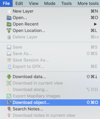
Knowing the object (way) ID, we can use the “File -> Download object…” functionality (Ctrl/Cmd+shift+o):

See full entry

Posted by BudgieInWA on 20 February 2022 in English.

A couple of weeks ago a small group of local Perth mappers came together in Claremont to meet with the local OSM community, learn a little more about contributing to OSM, and do some on the ground data gathering. Here, I will ~~ramble about~~ reflect on the experience and the planning of the event.

Although the turnout was small - just 6 of us - the event met its goal and I am considering it a success! I am Hoping that the humble little gathering will be the beginning of an ongoing community building activity.

See full entry

Location: Claremont, Town of Claremont, Western Australia, 6010, Australia