 OpenStreetMap

new arabic font on the map is awesome …
Diary Entries in English
Recent diary entries

Dear all,
Today, v2.44.1 of the openstreetmap-carto stylesheet (the default stylesheet on openstreetmap.org) has been released. Also, v2.44.0 was released last month without an email, so this email includes changes in both.
v2.44.0 has been rolled out to the openstreetmap.org servers, but v2.44.1 has not yet.
Major changes are
- Rendering of restricted access roads and paths significantly changed
- Changed to use Noto fonts for all languages
Other changes in both versions include
- A code of conduct adopted, based on the Go code of conduct
- Adjustments to city wall rendering
- Revised low zoom place rendering
- Render both house name and number if address has both
Thanks to all the contributors for this release, in particular Lukas Sommer, Hsiao-Ting Yu and vholten for work in debugging complex font issues with the Noto CJK fonts.
For a full list of commits from both releases, see https://github.com/gravitystorm/openstreetmap-carto/compare/v2.43.0…v2.44.1
As always, we welcome any bug reports at https://github.com/gravitystorm/openstreetmap-carto/issues

Many mappers agree that simple and accessible editors are hazardous: the simpler editor is, the easier it is for a horde of newbies to submit wrong data. This was a main argument against Potlatch, and then iD. Now MAPS.ME built-in editor allows for changing tags and adding nodes with just a few clicks for any of our tens of millions of users. Which of course has led to a number of questionable edits.
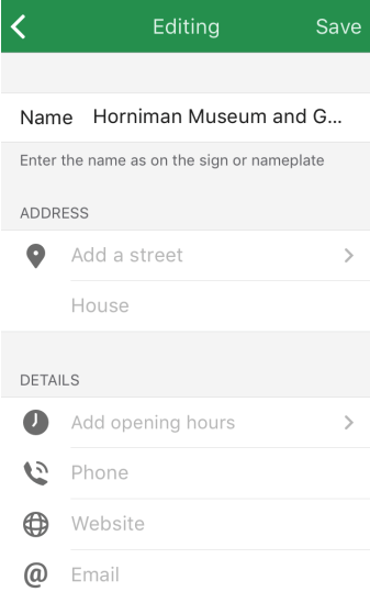
The first field in any place card is name. When we released the editor in April, it was a single field for editing the “name” tag. You changed a name — the new tag value was uploaded to the map.
Complaints started coming almost immediately. Turns out, some tourists were renaming attractions to their language for easier navigation. If you look at the Questionable Edits wiki page at the time, you’ll see that names in wrong languages are the most worrying kind of edits.

Population numbers turn out to be pretty important for rendering places at the correct zoom level. Since ‘town’ or ‘city’ is the highest possible qualification for any large urban centre (whether a sleepy 100 000 population suburb or a 10 million population metropolis) there may be many of these places very near each other. On lower zoom level, the renderer has to make a choice on which cities to show. Without any population numbers, no decision can be made, thus no names are rendered.
The default Carto layer does take population into account, and it can be seen that it is a major factor in deciding which place is shown at lower zoom levels.

In green are cities I’ve recently added population number to (number is brackets is the urban population). These are all rendered as long as the labels fit nicely without overlapping. It is not strange that the desert town of Hami is labeled at this zoom level. It should be, because it is a major stop along this transport corridor.

Update: Thanks Operations for blazing quick response, new FreeType is on the server and rendering should back to normal after cache invalidated.
:D
After the Noto CJK finally landed in the Standard layer, Boldness issue became a major problem for them.

Investigation by ` vholten` proved it was caused by the old FreeType version (2.6.1) in the rendering server, but it seems there is no easy or safe way to fix the issue.
- Converting to (Cubic) OTF to (Quadratic) TTF will take very long time and the result may not be loseless.
- Upgrade newer FreeType via third-party PPA, or patch and build old FreeType from
apt-get sourcewill work, but dangerous and will become a maintenance hell.
Maybe we should give up on fixing it until we can get newer Linux distro?

My father loved a good natter and I was born & grew up in Hull (a major sea-port in the East of England); these are two of my excuses for being able to talk the hind legs off a donkey. I do find it, however, to be a major asset whilst mapping as long as it is married with active listening (as we shall see shortly).
It was perfectly normal in my youth to strike up a conversation with a perfect stranger at a bus-stop. Or rather, normal for Hull. Indeed, on one of my first visits to London as a teenager (late 1960s) I was blanked by someone when I asked for directions, and was so upset by their ignorance that I chased after them & said in a loud voice “EXCUSE ME ..!”. I quickly learnt that such stand-offish behaviour was normal for London.
Nottingham is halfway between Hull & London and is capable of displaying either kind of reaction (warm or cold, with Hull as a warm place & London as most cold) (which makes Nottingham a bit tepid, of course). Nottingham folks have proven to respond very readily to my questions about their neighbourhood and have indulged my nosiness (another vital personal asset) without a qualm once they have settled themselves to my reasons. Intelligence supplied from householders is the very best asset for every mapper.
Today’s small snippet of such intelligence concerns a rockery protected by CC&R (a small bet: that this is the only one like this on the UK map).
CC&R:
Declaration of Covenants, Conditions, and Restrictions (CC&Rs) … the rules of your neighbourhood (as found within House Deeds)
I was paying a second visit to a service road at the bottom of Anne’s Close, Porchester Gardens. The householder from the end-of-terrace house was busy with a couple of others hauling wheelbarrows along a footpath that I’d mapped on my first visit. The state of that walk at the back of the houses had to be seen to be believed:

I live in Tarrant, Alabama, not Birmingham. Fix your errors or be sued!!!
Since I do a bit of university mapping, I thought I might note a few reasons why you should map your local university, especially since universities provide their own maps.
Support disabled students.
OSM includes tags that help blind and wheelchair bound students get around. Most proprietary maps ignore these users. Institutions that ignore OSM disabled tags or fail to help disabled users through another mapping solution are effectively discriminating against their disabled students through inaction.
Synergize with the community.
Often Universities and the town or cities that surround them have completely different cultures. By improving OSM on campus, outsiders not using a university’s official app can still navigate effectively.
Encourage Student Creativity
Unlike proprietary maps, OpenStreetMap is free for anyone to use. Students may use OpenStreetMap data legally in their projects through the ODbL. Encouraging the use of proprietary maps on campus locks students out of that data, stunting their creativity.
Commitment to Transparency
Any university that wants to commit to open technologies should at least have a well mapped campus on OSM. Having a well mapped campus in Openstreetmap is like having a well written Wikipedia article. An easily accessible and honest source of information for the community can boost a university’s reputation in the free and open source software communities, and elsewhere.

At Open Labs Hackerspace ( https://openlabs.cc/ ) we want to have a more active community for OSM so we will have an activity ( https://openlabs.cc/map-thon-nr-5-permiresojme-te-dhenat-e-openstreetmap/ ) and event in facebook ( https://www.facebook.com/event/183834142053445/ ). Join us.

My job requires me to travel a lot in villages around my place of posting. I have added many GPS traces of tertiary roads that are unmapped on OSM. I have some internet access issues and time restraints. If there are any good people wanting to contribute, please check my traces around the location given below and map the roads.
(The traces are almost always travelled by a car).

Dropping off a letter in the mailbox at the end of the street, I noticed this sticker was attached:
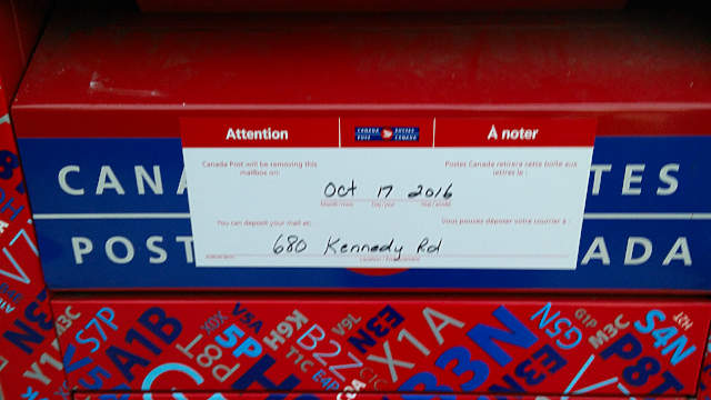 So that means by the middle of the month my leisurely 400 metre round trip to post letters is going to be over a kilometre, either to Mailbox: Node 705233932 or to the suggested Mailbox: Node 4433576259.
I looked around on the map for more amenity=post_box nodes around me, and found coverage was patchy. Local mapper andrewpmk has done some sterling work adding mailboxes, but there are some neighbourhoods even he can’t find time to go into. But there has to be a definitive list of mailbox locations in Canada, somewhere, right?
Wrong: Canada Post does not publish mailbox locations. There’s no way of finding a list or map on their website, and Canada Post confirmed to me that “we do not have a map for street letter boxes”. So it looks like we’re the only people mapping them, unless there’s a list I can get via an Access to Information (Freedom of Information) request.
Most spam gets quickly dealt with, but these three got through:
(later spam added Saturday + Sunday 8,9 Oct):
- spammy-link from Italian Wine Online (now gone)
- Inflatable bag Lamzac from “Junkstore” (Ukrainian spam; finally removed 29 Oct)
- Papier by yourfoto (now gone)

Recently the OpenStreetMap Foundation issued the OpenStreetMap Awards.
The whole thing was primarily organized by Ilya Zverev who deserves thanks for doing this and for the courage to try something new.
When this was first suggested it seemed like a good idea to me but during the process i already had some critical thoughts on the way it turned out. I did not want to speak up while the votes were still running not to influence the procedure but now i think it is time to bring this up.
First of all the whole process was quite biased towards English language activities. There were non-native English speakers among nominees and winners but almost everyone on the list was nominated for activities in English language. Since the whole process was done in English only it was not possible for someone who does not understand English to competently participate in nomination and voting and assessing someone nominated for activities in a language you don’t understand is not really possible either - the few suggestions in the first nomination round that were formulated in languages other than English never stood a chance. This is a hard problem. But still i think this can be done better with not too much additional effort.
The three stage process - open nomination, preselection by committee and final open vote again - does not really work in reality. It gives an impression of manipulation since it appears the preselection is used to eliminate undesirable nominees and the final vote therefore appears staged. In the future i would probably either skip the committee selection (making it a fully open process) or eliminate the final open vote making the final choice by the committee - which would of course require this committee to be selected in an open process somehow.

OpenStreetMap has a few assumptions about road surfaces, based on the fact most western cities have paved roads.
From osm.wiki/Key:surface
For roads for motor vehicles there there is normally an assumption that the surface is surface=paved unless otherwise stated. Paved in OpenStreetMap is non-specific and may cover sealed, tarmac, asphalt, bitumen. surface=unpaved is treated as the opposite of paved. More specific tags can used used for surfaces which are normally classified into paved or unpaved for routing purposes. Navigation software should assume that roads-that-are-not-paved will have slower driving speed (and therefore longer driving time) and may be impassable in some weather conditions.
In South America (Rural), Rural Australia, Africa, Haiti and more this is not the default. During activities like a HOT activation, quite a lot of road data gets added without specific surface tags.
In places like South America, Strava route building a big thing - but knowing if you can go on a road bike or a mountain bike is not something routing engines can answer with much certainty.
Alternatively, knowing if you are likely to need a 4WD vehicle in disaster relief is another use case which can’t be easily answered by a routing engine.
In an idea world, it’d be great if:
- ID had some notion of ‘rural’ vs ‘metropolitan’ mapping profiles; and allowed you to create a number of roads with the same surface properties as the last few you’ve traced.
- QA tools (maproulette? similar?) existed that looked at specific countries, finding highway=unclassified and highway=residential without explicit surface tags; plus a relationship to any bounding residential landuse to suggest a value (Big city? Its more likely to be paved residential roads)
- Something like DeepOSM that could guess the difference between “light, sandy coloured road” and “Dark, asphalt road” to suggest an appropriate classification.

All the houses on that side of the street are even-numbers, but Number 45, Moore Road is different from the others in more than one way. The most obvious thing is that, apart from a garden shed, there arn’t any buildings on the plot at all. The space bounded by hedges is identical to all neighbouring plots (check the map). The photograph above lets you see in a glance all that was at one time available to the folks of Nottingham town:— a plot of land for them to grow stuff on.
Nottingham was a highly dangerous town on 26 March 1887 when Porchester Gardens began. The reason that the town was dangerous was because of water-born disease (dysentry, etc.). Far too many folks were crammed into far too small a space, whilst their medical men were ignorant of the basic facts of their own trade. A garden like the one above was an opportunity to grow fresh food & enjoy fresh air & water. [I published a more complete story of Porchester Gardens here in June]
It’s a house at the Porchester Road end of Moore Road in Porchester Gardens, Nottingham. Now, I have to warn you in advance: Moore Road is a rich vein for English oddness. My last post was based on the smallest road in Porchester Gardens and, naturally enough, it is also off Moore Road (although at the other end, near Westdale Road West).
Anyway, you have your warning. I’ve just started putting Moore Road houses up on the map, and there are lots of odd things that I can choose to show. The first (strictly the second) is the very first house on the corner of Porchester Road and Moore Road. It looks fairly normal from Porchester Road, but round the corner on Moore Road it has an abutment and the abutment is castellated (for lovers of brick porn notice the Tamworth Blue Brick used both as a damp-proof course and also as decoration; very nice - the road is falling away from Porchester Road down the hill, so that damp-proof level is rather high at this point):—

(excellent!)

background:
Robot Mappers , machine-learning and artificial intelligence (“robot”) techniques ; http://mike.teczno.com/notes/openstreetmap-at-a-crossroads.html
Maybe, in the future we need some ethical suggestions, like
- “Robot mappers must be designed to assist humanity” meaning human autonomy needs to be respected.
- “Robot mappers must be transparent” meaning that humans should know and be able to understand how they work.
- “Robot mappers must maximize efficiencies without destroying the dignity of people”.
- “Robot mappers must be designed for intelligent privacy” meaning that it earns trust through guarding their information.
- “Robot mappers must have algorithmic accountability so that humans can undo unintended harm”.
- “Robot mappers must guard against bias” so that they must not discriminate people.
based on Satya Nadella’s A.I. laws
ps. I added this to the [OSM Wiki:Talk:Automated Edits code of conduct] (osm.wiki/Talk:Automated_Edits_code_of_conduct#Rules_for_Robot.2FA.I._Mappers)
Posted by OscarBrownbread on 6 October 2016 in English.

I wanted to name a road. At one place, the road was split into 3 small straight segments and I was annoyed because I didn’t want to name each one and there would be a small tag for each segment. “Ahhhh, I wiill just combine them” I said to myself! “Some idiot has left these segments alone” I thought again. Will ID let me combine these segments?….. yes! good. I was happy and my road was named.
I had a bad feeling, there was just this instant feeling of ohh, something is not right. Then it hit me ….town-land boundaries, ….. you know those annoying blue lines that are everywhere in Ireland….. the ones that I have turned off under Map Data-> Map Features-> Others. The ones I try to forget about. I turned them on and yea, I had combined the boundary relations when I had combined my road. Damn, what a mess. It was too late to fix late at night so I waited until morning. So after a bit of local history in town-land names, I undid my mistake.
My message is to be careful when combining ways and naming roads. On one hand, I want to name every segment so every house has a matching street name, on the other hand, i wish i didn’t have to name every little segment (this is especially true in housing estates with their little branch roads, all with the same street name).
I dunno, naming roads is funny, there are old road names, and official road names and there are the proper postal address names for the streets. Then there are the locals that have their own names for that part of town and if they are giving you directions, you better know them!! I prefer to keep the local names as long if they are well established. OSM is all about what is there right now, it can track the dynamic changing of a street name over time…. in theory….i think. What do you think local street names or strictly official street names??
I should probably go read the wiki and find out that it is all ruled out for me somewhere. I just started and I’m learning as I go and I am enjoying it, :)
…is called Ward Avenue and it is now back on the map. Here is the view from Moore Road, looking up the Avenue:

Those gates on the right are for a house on Moore Road and the fence straight ahead is the end of the road, which may help to show just how short this road is (there is only one house on the road; you can just see the left-hand front of the house tucked around the end on the right). On the other side of the fence on the left is Westmoore Close, and the reason that Ward Avenue has only just been re-instated onto the map is that a couple of years ago the straight bit of Westmoore was mistakenly renamed to Ward Avenue. Whoops.
I worked for a year as a volunteer at Goose Lake Prairie State Park near Morris, IL. I also live nearby, and am intimately familiar with the state parks up and down the Illinois River.
I notice that on OSM, especially at Goose Lake Prairie State Park that many paths are listed on the map, yet these are not shown as official trails on the park maps available at the visitor center. Since these are not trails that the park wants people hiking on is it proper to delete these from the map?