Diary Entries in English

Recent diary entries

Hello, everyone!

It’s my first OSM Diary post; please allow me to introduce myself. My name is Jikka and I just joined the mapping community some time during the second half of 2020 through Humanitarian OpenStreetMap Team - Philippines. I’ve long wanted to write an OSM diary entry (I’d already thought about writing something regarding AWS and PhilAWARE) but I wasn’t so sure if my thoughts (a newbie’s!) would be welcome. But, seeing the push for openness and inclusivity made me feel more confident in expressing myself. I’m sure there are people who share this sentiment. 🤗

Anyway, I am writing this just in case any newbie here reads the OSM diary entries. That’s what I did when I joined, and I learned so much from just being a #lurker lol. I’m sharing three trips for any newbie who wishes to contribute:

  1. If you are a newbie (welcome!), please add the hashtag #newbie when making changes and explicitly state in your comments that you are a newbie so that other mappers can guide you. (I’d like to thank arnalielsewhere for this tip!)

  2. That being said, please don’t be discouraged when other mappers add comments or send you direct messages to ask about your recent edits. Whenever they ask questions (usually about data that you ~unknowingly~ changed), just be honest and say you’re learning.

  3. Please join mapathons. It’s always good to have someone answer your questions real time. Lessens the chances of us newbies uploading changes that don’t necessarily improve the map.

The reason why I’m posting this is because we can’t really claim to be making OSM a free and inclusive community when we’re being discouraging to new mappers. Likewise, for newbies, we can’t cement ourselves in the discussion and the movement in general if we’re always discouraged by comments or if we’re intimidated by the system we want to improve.

See full entry

Posted by nickjohnston on 27 December 2020 in English. Last updated on 14 February 2024.

For months I’ve been mapping addresses in Cheltenham, England. I recently discovered the JOSM “Coloured Streets” style. It has improved my address mapping and might help you too.

The style shows streets and all the buildings and address nodes “on” them in the same colour. This makes it easy to spot buildings tagged with the wrong addr:street at a glance. It also clearly shows buildings with addr:housenumber or addr:housename (you must enable the latter in the settings) but no addr:street. (The JOSM validator checks for this too, but with Coloured Streets you can see the problem immediately.)

In this example, Ashcombe House, Outwoods, and Beechwood are in pink and therefore have an addr:street of Stanley Road, when they should be on Ashley Road. The mistake would not be obvious otherwise.

Screenshot of JOSM with the coloured streets style

If you look near the bottom right of this screenshot, you can see Windsor Street shown in orange:

See full entry

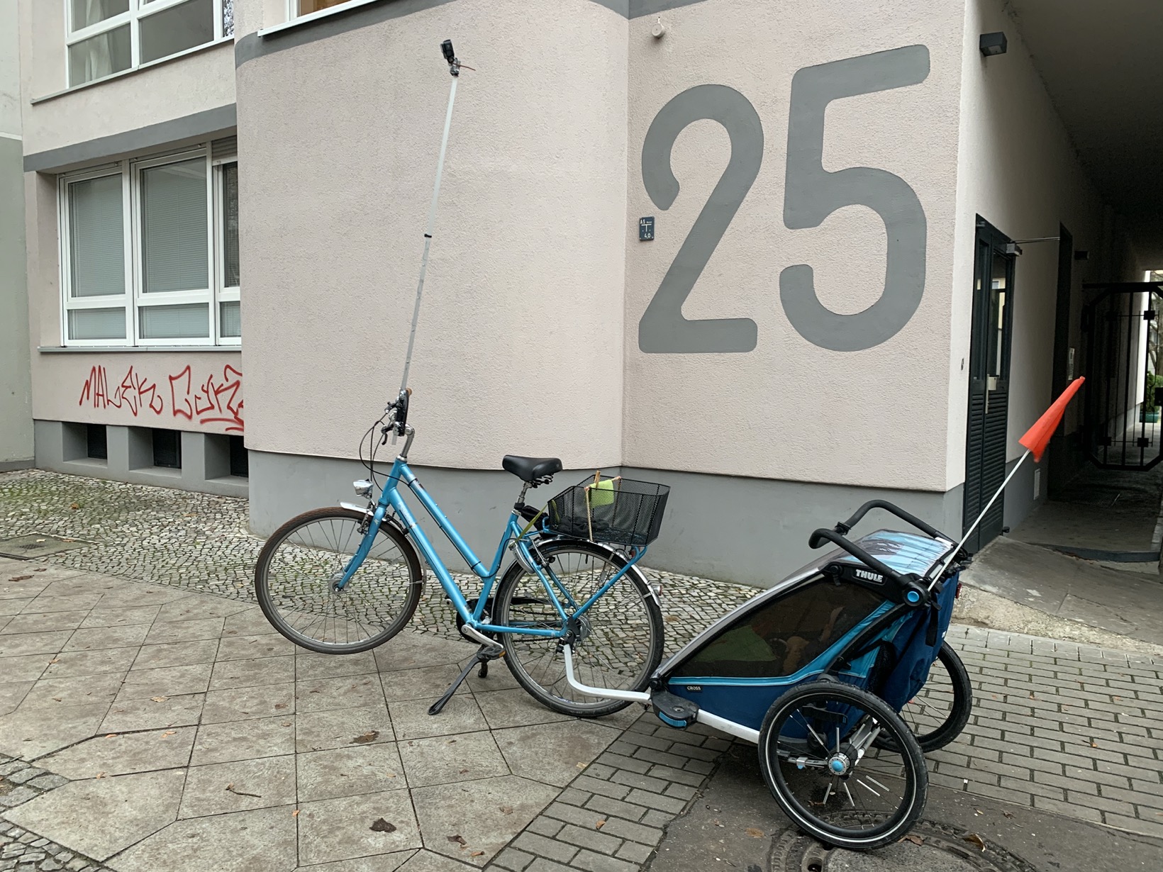
A year ago I started doing a lot of walking and cycling with my stroller. Naturally, I had to look for new ways to contribute to OSM. More on the go mapping – thank you GoMap! – and more passive contributions by providing street level images.

With this post, I want to share my prototype of a bike tripod to take great Mapillary images.

It looks like this:

Picture

Goals of my tripod prototype:

Goal 1: Elevation – Take pictures from as high up as possible

My goal is to create images that allow to map bicycle and pedestrian infrastructure. For Berlin, this requires the pictures to be taken either on the sidewalk itself or from high above on the lane. Otherwise, all you see are parked cars.

Goal 2: Field of view – Look ahead with privacy in mind

No 360°

See full entry

Location: Neukölln, Berlin, Germany
Posted by bo_hot on 26 December 2020 in English.

share

everyone you will ever meet knows someting that you don’t - Bill Nye

So given that it’s Friday and a cultural holiday for many, it seems only fitting that today is share day.

So, I thought that I should take a few minutes out to share a bit about this part of our RaDs.

This day is all about bringing together everything we heard through our conversations. We want to uncover the…
‘the things we don’t know,
the things know that just aint so that just gotta go.

What we do know know is confirmation bias exists so we want to use this as an opportunity not to solve but to surprise.

As we go through our share day we will be undertaking an exercise similar to a Johari Window.

See full entry

Location: Naz, Esserts-Salève, Monnetier-Mornex, Saint-Julien-en-Genevois, Upper Savoy, Auvergne-Rhône-Alpes, Metropolitan France, 74560, France
Posted by bo_hot on 24 December 2020 in English.

enagage

we need to turn up the volume in the silent spaces - Lily Cheng

One thing we really want to focus on during these engage days is to find out a whole lot of things. Summed up by meyrecent foray into poetry.

Hello, I’m Bo,
I know what I know,
But not what I don’t know,
But it’s what I know that just ain’t so,
That’s gotta go.

This is what excites me about engaging and exploring. To question everything I know and be surprised. I want my assumptions to be challenged and my beliefs to disrupted.

So come and make hot_tech question itself, by signing up here.

Location: Naz, Esserts-Salève, Monnetier-Mornex, Saint-Julien-en-Genevois, Upper Savoy, Auvergne-Rhône-Alpes, Metropolitan France, 74560, France
Posted by Kateregga1 on 23 December 2020 in English. Last updated on 31 December 2020.

This year, the Humanitarian OpenStreetMap Team (HOT) community received funding from The Audacious Project. Over the next five years, this funding will enable us to scale up its support for local mapping communities with the aim of mapping an area home to one billion people, adding places at high risk of natural disaster or experiencing poverty.

Over five years, HOT plan to:

  • Set up a network of regional hubs in South Asia, East Africa, West Africa, and Latin America and the Caribbean, which will engage with local mapping communities, facilitate knowledge exchanges, distribute funding, and provide training and support in order to massively scale local edits to OpenStreetMap in 94 countries
  • Invest in technologies that enhance mapping contributions on mobile to enable scaling of local contributions to OpenStreetMap
  • Invest in map data quality and ethical collection and use of map data
  • Work with humanitarian organizations, governments, and other actors to help them use OpenStreetMap to deliver more effective and efficient aid
  • Work more closely with the OSM community/OpenStreetMap Foundation (OSMF), supporting the community and core systems and software

See full entry

Posted by bo_hot on 23 December 2020 in English.

enagage

every good conversation starts with good listening - unknown

And that’s exactly what we plan to do.

The format will be mostly similar, however, less connecting as a team and more connecting with others connect with from day 2. While we are on the hunt for answers, we will actually be capturing a whole lot more questions in the form of HMWs, or How Might We…

The way these conversations work will be pretty straight forward. We will use our conversation starters based on our open queries and assumptions that are linked to our big question from day 1. We will open up any range of conversation paths and let those like you guide the conversation where is most important for you to take it.

As we go through this process, the team will be listening and everytime we hear something of interest it will be captured as either a note, or a ‘How might we…‘ Let me give you an example.

See full entry

Location: Naz, Esserts-Salève, Monnetier-Mornex, Saint-Julien-en-Genevois, Upper Savoy, Auvergne-Rhône-Alpes, Metropolitan France, 74560, France
Posted by bo_hot on 22 December 2020 in English.

connect

great conversations begin with great connections - Oprah (kind of)

So at the end of RaDs day one (start) we have three takeaways:
_ A big question
_ A list of open queries
_ A list of assumptions

Great, easy, now we just need to some answers. Actually we have some more questions.
_ Who will be best placed to answer our big question?
_ Who can close our open queries?
_ Who will be able to validate our assumptions?

It’s time to connect

Following the same format as w1_monday, we will aim to do two main things here.
1. Connect people to the big question, our assumptions and our open queries.
2. Literally connect with the people we would like to have conversations with.

Would you like us to connect with you? Do you have something to tell us? If so, please fill out this form >

See full entry

Location: Naz, Esserts-Salève, Monnetier-Mornex, Saint-Julien-en-Genevois, Upper Savoy, Auvergne-Rhône-Alpes, Metropolitan France, 74560, France
Posted by bo_hot on 21 December 2020 in English.

start

Start where you are, with what you have, do what you can - Arthur Ashe

If you want to be involved, please join in by completing this form

To start we need to begin with a single step, a single idea, a single question.

The play by play for each day will look somewhat similar. It will be a mix of individual, group, sync and async work. This is to accomodate multiple timezones, multiple technologies, multiple working styles and most importantly, multiple people :)

Below is a quick snapshot of what each day’s sessions will look like and also shows what the activities we will be undertaking on w1_monday.

See full entry

Location: Naz, Esserts-Salève, Monnetier-Mornex, Saint-Julien-en-Genevois, Upper Savoy, Auvergne-Rhône-Alpes, Metropolitan France, 74560, France

Context on why this post-question:

Two days ago there was an incident in my area where a truck went through the city center even though it shouldn’t, and damaged a street sign while trying to turn. According to the article of a local blog, the truck driver said he was confused by the GPS and went the wrong way. No mention on which GPS he was using, but regardless that made me wondering of how I would tag to make such trucks go the proper way.
At the point where the driver took the wrong turn, there’s a visible traffic sign (the one shown below). Personally, that raises the question on why he followed his GPS routing instead of the traffic sign, assuming he saw it beforehand, but that’s not the point of this post anyway. Traffic sign, heavy trucks, turn left, if above 10 tons (photo is mine)

The traffic sign, which is not listed in the Greek Highway Code, means that if the heavy truck is above 10 tons, then turn left.

See full entry

Location: Community of Argos, Municipal Unit of Argos, Municipality of Argos and Mykines, Argolis Regional Unit, Peloponnese Region, Peloponnese, Western Greece and the Ionian, Greece
Posted by TheDutchMan13 on 21 December 2020 in English.

As of today, I am ending my contributions to opensteetmap. I have come a long way in OSM from the day I first started editing the map in my local area of Glendale, Arizona. To see the influence of corporation’s & the impact of corporate editing on OSM since then has made me realize that I no longer feel the excitement I use to have for editing maps. I have enjoyed the time I have put into OSM, but today is the end of my contributions. Thank you to everyone who has helped me along the way with suggestions and guidance. I appreciate all the help that was given.

Name - (Hans De Kryger) Username - (TheDutchMan13) Start & End Date Of Edits (April 05, 2013 - December 20, 2020)

Location: Roles Inn of America, Glendale, Maricopa County, Arizona, 85301, United States

The best journeys answer questions that at the beginning you didn’t even think to ask - Yvon Chouinard

For the next two weeks, I’m going to be posting (short) diaries about some design thinking that hot_tech is going to be undertaking to kic-off 2021. After such a bumper year and the welcoming of some fantastic new members, we thought now would be the perfect time to get to know you and what you need from us. To do this, we will be undertaking a series of two week sprints, that are a combination of a rapid assessment & design sprints.

So what are RaDs?

The goal of RaDs is to better understand what people need (or don’t need) from the OSM and [humanitarian]OSM - [h]OSM - universe. We want to know why people come to [h]OSM and what matters most to them when they are here. Most importantly, we just want to get to know more about groups of OSM users to learn more about your common goals, interests, values and purposes. We want to know what makes you feel whole and included.

If you don’t know what a Rapid assessment or a Design sprint is, great! Follow along for the next two weeks and each day I’m going post an overview of what the day will entail once the sprints are underway.

If you’re still not hooked, here’s a quick visual to give you an idea of what we will be doing.

See full entry

Location: Naz, Esserts-Salève, Monnetier-Mornex, Saint-Julien-en-Genevois, Upper Savoy, Auvergne-Rhône-Alpes, Metropolitan France, 74560, France
Posted by SimonPoole on 18 December 2020 in English.

Vespucci 15.1 has been available for a couple of days now from googles play store marking the third larger release (14.1, 15.0 and 15.1) this year and our traditional release for the holiday season.

Details on what has changed can be found further down, but first let me point out a few important points from the past year and things to be aware about that will be happening in 2021.

The OSMF and iD

2020 marked the OSMF becoming a participant in the OSM editor market place, you might say what does that concern me? Well, even if not all the developers are competing for funding (like iD, Rapid, StreetComplete and many others), all are competing for relevance. Or put differently: mapper market share. How exactly this will play out going forward isn’t clear yet, but it already has consequences in development, for example I’ve put all tablet related improvements on hold. The required effort just doesn’t makes sense with the OSMF expanding iDs use outside of the classic desktop on to tablets..

More https/SSL woes

A couple of weeks back Let’s Encrypt dropped a bomb. Let’s Encrypt is by far the most popular provider of free encryption keys for https use, and are widely used throughout open source and data, and the OpenStreetMap ecosystems. For example Let’s Encrypt certificates are used on all OSM infrastructure that has so fully migrated to https that use without is no longer possible.

Android 7.1 as the oldest version that will no longer work with Let’s Encyrpt is fairly young, and lots of users are “still”* using it. An estimated 33% of the 2.5 billion Android devices will be effected. So we can’t simply ignore this happening.

See full entry

OSMCha helps analyze, inspect, and verify changes in OpenStreetMap as they happen. The entire team building OSMCha has been proud to see its wide adoption by individual contributors and companies in the OpenStreetMap community. I continue working on OSMCha through support from Mapbox, who have been using and helping develop and host OSMCha for years. The Mapbox Data RAVE team uses OSMCha everyday as part of their work validating changes in OpenStreetMap.

That’s why it’s essential that OSMCha is operationally excellent, with dependable uptime and a team on hand to handle issues and deployments. Since the beginning of the year, I worked closely with the “RAVE tooling” team to improve the infrastructure setup for OSMCha for better performance, instituted on call support, and moved the service to the osmcha.org domain. I continue to work hard to maintain the OSMCha open source code base and community and develop new features. There’s many useful new features and more to come.

Improved Visualization

See full entry

Posted by bo_hot on 16 December 2020 in English.

Welcome to hot_tech…Hya, Diana, Lily, Rob

So as everyone is well aware, it’s time to scale up time over here and hot_tech is no exception. We have been afforded an ‘Audacious’ (https://www.hotosm.org/projects/audacious/) opportunity to welcome some impressive new talent into the fold. I was once told never to assume you’re the smartest in the room and with the addition of these four new team members, I know for sure that I am not.

So, let me be the first to share with you a quick intro to each of the new team members, why they decided to join us and why we wanted them to be a part of the team. I have just done a short bio here for each, but you can read the full post over here » hot_tech blog

Hya Umaran
Hya Umaran

See full entry

Location: Naz, Esserts-Salève, Monnetier-Mornex, Saint-Julien-en-Genevois, Upper Savoy, Auvergne-Rhône-Alpes, Metropolitan France, 74560, France
Posted by thomersch on 16 December 2020 in English.

OpenStreetMap Calendar is here for over a year and now we’re ready to make the next step: Let’s unify forces and put osmcal onto the wiki’s main page. Thanks to the microgrant, I was able to dedicate a good amount of time to extend the software ecosystem and make osmcal ready for everyone.

The OSM Wiki now has an osmcal extension, which makes integrating a calendar into any wiki page as simple as typing <osmcal />. It even supports filtered calendars, e.g. the United States wiki page contains all upcoming events just in the US.

The logical next step is to deduplicate the work needed to publish an event, so we’re aiming to switch the calendar template inside the wiki towards the end of 2020, so for 2021 events you only need to put events into osmcal and they’ll be available anywhere.

There are some cool external integrations which reach even more people:

See full entry

Location: 50.937, 6.960
Posted by se_mower on 14 December 2020 in English.

Hello OSM.

Shamed to think that after almost 4 years of contributing (under various usernames) that I’ve never properly indulged in writing my experiences in an OSM diary. Today this changes. Hilariously, the first post feels like the hardest to write (in fact, it’s been on my ‘to do’ list for about 3 months).

There are many things that I want to write about: reflections on recent events, inspiring statements and stimulating conversations around hOSM community, joining LCCWG, my admiration for the speed and vitality of the development of the “Call to Take Action and Confront Systemic Offensive Behaviour in the OSM Community”, and even my frustration in differentiating between flat number and house number tags (more of that exciting topic to come in future posts!).

But for now, I’ll start with introducing myself:

Hello, I’m Sophie. Contributor to Maps.me since 2016. Missing Maps volunteer since 2017, MM facilitator since 2018 (corporate mapathons), HOT employee since April 2020. Lives in Cambridge, UK.

Nice to meet you!

Location: Petersfield, Cambridge, Cambridgeshire, Cambridgeshire and Peterborough, England, CB1 2EE, United Kingdom
Posted by BikeForestExplorer on 13 December 2020 in English.

Suddenly I discovered that everyone’s favorite Strava, Komut, as well as bike navigators are using OSM as work maps. And all these paths in the forest that appear out of nowhere on the route (there weren’t any on the map!), You can add yourself. Which I did, importing tracks from Strava and looking for unmapped places where I drove. I feel like a cartographer of Mars