Diary Entries in English

Recent diary entries

Posted by Mahede Hasan on 15 September 2020 in English.

It’s very silly question but I like to describe my opinion. Once upon a time I could’t know how to use map let alone edit. When I stated my journey with OSM tried to add my own locality’s data first as a beginner mapper all of us do it like me. There are lots of mapping organization in the whole world but openStreetMap is totally different from them.

We can’t edit all the mapping sites but osm gives us this opportunity to edit in here. The community is always being ahead for humanitarian works instead of business purpose use. May some guys are using for business purpose but humanitarian action is first priority.

I would like describe myself an OSM Mapper. Happy Mapping.

Posted by Foomandoonian on 14 September 2020 in English. Last updated on 16 September 2020.

What are these diaries for I wonder?

Today was my first proper contribution to OSM. I made over 100 edits using the StreetComplete Android app plus a couple of manual edits using the website. For a while at least, this is going to be a fun excuse to get some exercise.

My plan, I think, is to…

  • Learn more about the philosophy behind OSM (I’m interested in the cycle, transport and humanitarian maps)
  • Get a bit more familiar with the tools and mapping
  • Maybe try to come up with some specific ways to contribute that interest me. I’d like to add more of the BTN BikeShare hubs for starters.

My goal outside OSM is to learn QGIS and more generally how to make maps, for Wikipedia but also for my own personal interest.

We’ll see.

Location: Aldrington, Portslade by Sea, Hove, Brighton and Hove, England, BN3 5HJ, United Kingdom
Posted by amapanda ᚛ᚐᚋᚐᚅᚇᚐ᚜ 🏳️‍⚧️ on 13 September 2020 in English. Last updated on 14 October 2020.

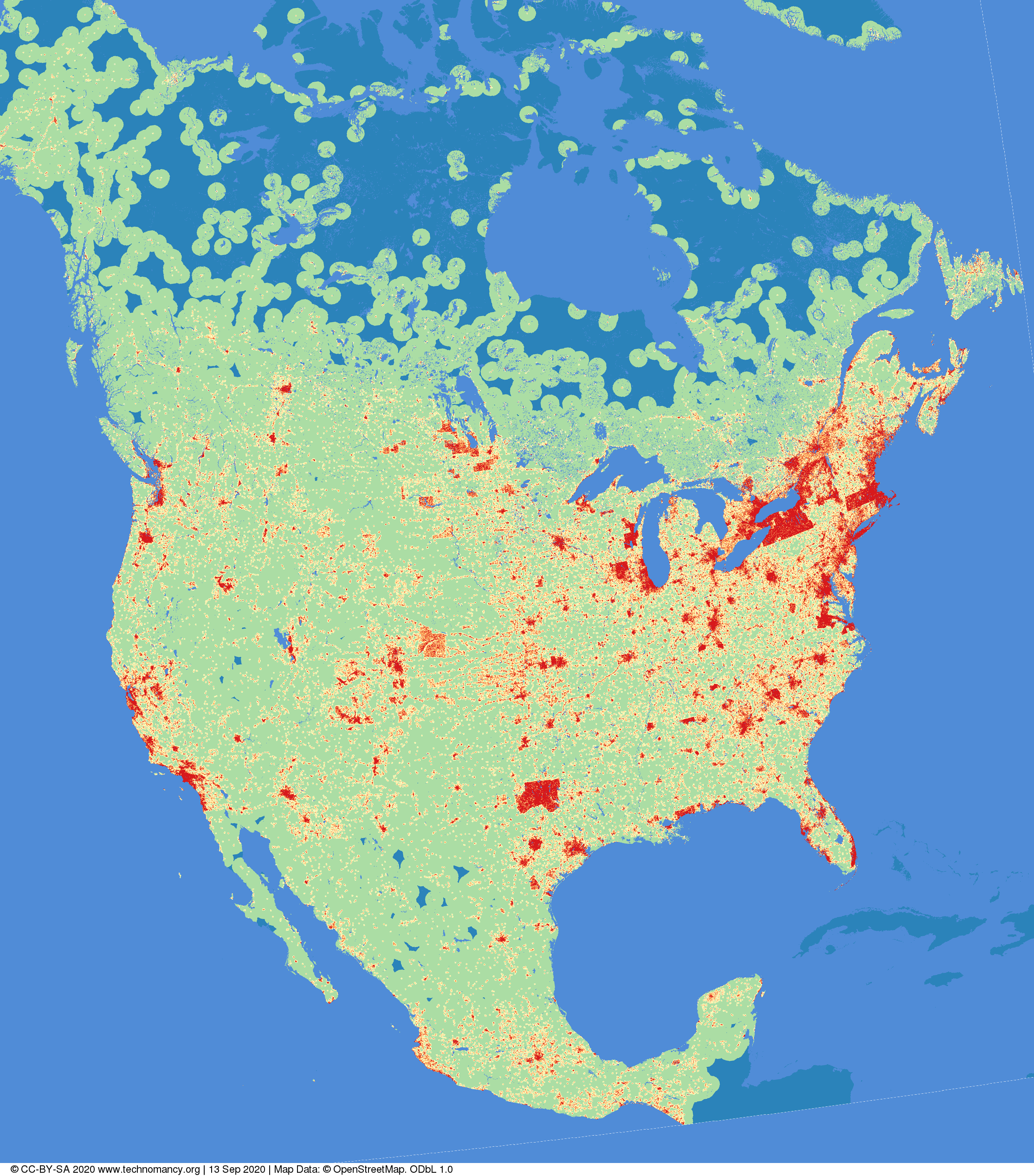
Have you ever thought “Gee I wonder if you took #OpenStreetMap data for North America, and coloured the image based on the distance to the nearest building?”

No? What kind of person are you?

(red=<1km, orange=1→2km, yellow=2→5km,green=5→50km, blue=>50km Image © CC-BY-SA 4.0 technomancy.org, Map Data © ODbL OpenStreetMap Contributors) Canonical Web Page: “Distance to nearest building in North America” on Technomancy.org map of north america

A few days ago I wrote about my plans to map the Mountains-to-Sea Trail, putting each segment into its own relation (and then putting all relations into the main MtS Trail relation). This has now been completed!

There are a few more things that need to happen to complete this trail.

  • Alternate routes need to be added.
  • Drinking water, toilets, and other points of interest need to be mapped along the trail.
  • Roadways need to be aligned (trails look pretty good, I think).

It will definitely take a while to complete these tasks but perhaps if done by section it will make it a slightly easier to keep track of the tasks.

Posted by MichaelRaj on 12 September 2020 in English.

Is it better to tag the complete fuel station area as amenity=fuel or is it better to tag only the roof with building=roof along with amenity=fuel.

Also, will it create any data duplication if I use amenity=fuel tag to the service road after adding the same tag to the area around fuel station?

Location: Melapalayam, Palayamkottai, Tirunelveli, Tamil Nadu, 627005, India
Posted by BaddDadd on 11 September 2020 in English. Last updated on 15 September 2020.

This is the code referred to in my previous entry. This is written for Matlab. It should work in Octave as well, but I haven’t tested it.

Edit: Updated the code to return arc segments split into two or four pieces, depending on deviation from a straight line. Also, code now supports many bearing delimiters for degrees, minutes, and seconds.

See full entry

Posted by BaddDadd on 11 September 2020 in English. Last updated on 15 September 2020.

Well, really just metes

Anyway, I had a description of the property, which can be hard to follow for most of us. Here’s an example description of part of Buttonbush Nature Area:

Commencing at the South ¼ corner of Section 10, T2S, R6E, City of Ann
Arbor, Washtenaw County, Michigan; thence N01°57’53”W 60.00 feet
along the North-South ¼ line of said Section 10 and along the East line of
Foxfire Condominium, Washtenaw County Condominium Subdivision Plan
No. 136 for a PLACE OF BEGINNING; thence continuing N01°57’53”W
2208.89 feet along said North-South ¼ line and along the East line of
Foxfire Condominium, Washtenaw County Condominium Subdivision Plan
No. 136 and along the East line of Fox Ridge Commons Condominium,
Washtenaw County Condominium Subdivision Plan No. 176; thence 96.56
feet along the arc of a 7442.41 foot radius circular curve to the right, chord
bearing N81°07’45”E 96.56 feet along the South right-of-way line of US-23
(variable width); thence S07°00’18”E 195.59 feet; thence S48°50’07”E
5.51 feet; thence S01°57’53”E 2022.40 feet; thence S88°16’54”W 117.07
feet along the proposed north right of way line of Dhu Varren Road (60
feet proposed half width) to the Place of Beginning, being a part of the
Southeast ¼ of said Section 10 and containing 5.90 acres of land, more or
less.

My eyes glazed over the first time I read that. But after looking at it for a while, I realized that i only needed a little bit of that to figure out the boundary. Most of it was just prose.

To get the data I needed, the first step was to eliminate all the prose, and put it in a standard form that could be more easily read in. I copied the text and just started deleting the extra words. This became:

See full entry

I have finally bitten the bullet and acquired a GoPro Hero 5 Black as well as a windshield mount for it, and tomorrow will test it out for collection of Mapillary imagery. Until now I have used smartphones and the Mapillary app exclusively, but that only works if someone else is driving and I can restart the video when the app invariably either crashes or locks up at some point. Since retiring from the ambassadorship, I am now my own chauffeur and no longer enjoy the luxury of being a passenger who can serve as the photographer. Mrs. Mustard kindly granted permission to splurge on a dedicated camera for collecting ground-level imagery.

The OSMF Board decided in August to bite another bullet and resolved to finance a full-time developer of iD, the OSM default editor, plus a full-time system reliability engineer position to ensure maximum reliability of the hardware. The Potlatch maintainer also received a grant for porting Potlatch, since Flash is soon to be deprecated, and some mappers are still using Potlatch very heavily. The Board expressed a strong desire to maintain diversity in the editor ecosystem despite the dominance of JOSM and iD. JOSM maintainers were pinged but indicated that financial support for JOSM is not needed. These decisions were not taken lightly, were discussed with the community, debated within the Board itself, and in the end adopted unanimously because maintenance and support of core infrastructure are crucial to the OSM project, and demands on that infrastructure are only growing.

The North Carolina Mountains-to-Sea Trail extends from, as you might guess, the mountains of North Carolina to the ocean. The last time I had looked at the MtS website I noted that the trail hadn’t been fully fleshed out yet. There were many partial sections but they weren’t all linked up. Now everything is linked up with a few proposed changes coming over the next few years.

Because OSM data reflected the partial trail, I’m working on verifying the data that is currently there as well as adding the missing data. I’m also breaking up the overall relations into segments, as per the MtS website. I’ve currently mapped (or confirmed the existing data) for Sections 15-18 (516 km!). I hope to have all of this finished within the next week or so.

Location: Stacy, Carteret County, North Carolina, 28581, United States

I worked for some time to create Mapnik-based tileserver where names are internationalized. I managed to do it by pulling data from names from Wikidata and Wikipedia. Project is released at: https://gitlab.com/stalker314314/osm-wikinames

You can see showcases at: https://gitlab.com/stalker314314/osm-wikinames/-/blob/master/showcase.md

Idea is to create new columns in PostGIS which get populated from wikidata/wikipedia and then, use those columns in renderer.

Do check it out if you find this useful and submit issues if you see any bugs, or this doesn’t completely do the job for your case!

Recently it came to my knowledge that it’s preferably to upload almost every change you do, instead of doing several changes and then uploading them, because this raises your amount of changesets, which is what other are looking into others. They don’t look how many changes you do in OpenStreetMap, but rather how many changesets you have.

What I was doing till 2 days ago was pretty much 1 changeset = ~80-100 changes, mostly because the iD was going red after 100 changes. So, even though I’ve done a lot of changes, for example in my area, to another person it may not look enough to be considered.

Now I do 1 changeset = ~10 changes.

The reason I was doing that previously is because of my way of thinking for Wikimedia-related edits. Few and massive edits rather than several and changes of like a sentence at a time.

Posted by Conor Ryan on 9 September 2020 in English.

This is my first diary entry here on OSM. It’s a way for me to keep track of my own work here, but comments from others are welcome. I’ve been an OSM member for seven years plus but still consider myself a novice user. The number of edits I’ve made is fairly minuscule in comparison to some, although I have used OSM data to create maps in QGIS. My background is in geography and rural development and that is the focus of my interest in OSM. Urban areas seems to be pretty well mapped here but once you head outside the cities and towns there is a lot of blank space on the map. I’m aiming to map rural areas Ireland in as much detail and as systematically as I can. I’m particularly interested in things that are challenging to map, like smaller rivers and streams, small areas of woodland, farms, and old ruins and monuments. I also have an interest in placenames that are known and used locally but are not officially recorded. I’ve already mapped the extent of what I know from my own local knowledge of where I live (near Youghal, Co, Cork, Ireland) and where I’m from (Drom & Inch, Co. Tipperary, Ireland). So now I want to move on to systematic surveying of other rural areas through a combination of on the ground fieldwork and using aerial imagery. I’m also trying to switch from the in-browser editors to JOSM. Along the way I’ll update with challenges and problems as they arise. Tips from other users and invitations to collaborate are welcome.

Posted by smootheFiets on 8 September 2020 in English. Last updated on 11 December 2020.

This is probably not useful to anyone but myself.

Construction

List of buildings that are listed in the BAG as “bouwvergunning verleend” and that I’ve requested to be imported as building=construction. Check in due course whether construction is finished and update!

Ruins

Buildings that I’ve marked as ruins:building=*. Check in due course if they can be deleted or if anything is rebuilt!

Areas that need attention

  • Noordhorn, Moeshorn 15a and surroundings; Langestraat 18c (new?) + 2*18d
  • Leek, North of ‘de Wiecken’