Diary Entries in English

Recent diary entries

Posted by Tomasz Chodorowski on 29 June 2020 in English.

Why is there no OSM Sandbox for map editing? People should practice map editing on a empty map with satellite images so they can actually build the world, learn how to actually edit, etc.

Why has this not been implemented yet? Are you people crazy? What if editors make some nonsensical edits on the map so they can learn how to edit? This has to be added to OSM for both guests and users.

Posted by joost schouppe on 28 June 2020 in English.

Some time back, I wrote about my hopes and wishes for last year’s Board election. The reality has far surpassed my expectations. I’m impressed with how much has changed with the new set-up.

Even though ideologically, we remain just as diverse, this board is getting into much less conflict. Of course, we don’t agree on everything. But we seem to be much more capable to reach a common ground on things. This has made this Board, in my experience, much more productive than the previous one. What used to be an insurmountable hurdle, something small like switching from audio to video conferencing, was now quick, easy and straightforward.

Big part of that increased productivity, is that we have a new Chair (Allan Mustard), who takes the role much more as an active leadership role than the previous one. That is only possible because he happens to be recently retired, and willing and able to invest much more time in the role than any of the other Board members can.

We also have a new Treasurer - Guillaume was the only one to offer himself for the role, though he probably didn’t expect there to be no one else to volunteer. As he was starting the role, there was a crisis straight away: our bank kicked us out. The amount of time he has needed to invest in resolving this (and all the technical consequences of that) has been enormous, and beyond what can be expected of a volunteer. Thankfully, his free lancing was a little slow because of the corona crisis.

See full entry

Location: Fournol, Saint-Julien-de-Jordanne, Mandailles-Saint-Julien, Aurillac, Cantal, Auvergne-Rhône-Alpes, Metropolitan France, 15590, France

I try to capture Mapillary imagery where I can, mostly from my bike, sometimes 360 imagery sometimes forward facing only.

I started in 2017 basically just to give it a go, I bought a 360 camera, the LG 360 CAM. Even that was a struggle, they didn’t sell them locally here so I needed to buy from random sellers on ebay. LG don’t make these anymore, but I’ve stockpiled 3 which is good if one breaks or for swapping them when the battery runs out. Overall I’m happy with the camera, it’s not top of the line, but for the price I paid about $100USD each they have satisfactory image quality, battery life and capture rate.

While I can’t usually use my 360 imagery to read off the smaller road signs (only larger destination signs) I find the it’s much easier to do mapping later from 360 images.

After a capture, I’ll usually go through and use it to add in as much detail to OSM as I can from my imagery, and then upload it to Mapillary.

While I’d get value even without uploading to Mapillary I feel this is important to be able to provide some kind of verification to my edits. It also proves very useful later on when reviewing others edits, I can take a quick look of what was on the ground before from Mapillary and just check that new edits look right.

I’ve been very supprised how much I’ve ended up re-checking my captures in Mapillary. Many times reviewing edits in OSMCha I’d be surprised that I actually had coverage for that area.

At the start, mapping out a whole city might seem like too big a task, but just like OSM, chipping away one bit at a time, progress slowly is revealed year after year.

Anyway, back to the point of this diary entry. I recently upgraded to a new phone and found that the LG360 app no longer worked. It would connect to the camera (to see the camera stats) but wouldn’t let me start the capture.

See full entry

8925 COVID-19 - YELIMANE CERCLE 3 - KAYES REGION, MALI

HOT has been requested by OpenStreetMap Mali and the Mali Red Cross to map areas in Mali susceptible to, or identified as impacted, by the COVID-19 outbreak. Please join our global effort to help control this disease by mapping on this project.

Globally HOT is committed to fighting COVID-19 by providing 3 critical services:

Helping government agencies and responders with basic data needs: we’re providing this through the UN’s Humanitarian Data Exchange, among other ways. Helping to Identify populations living in places most at risk: prioritizing our existing queue of mapping projects to get volunteers immediately mapping areas with high proportions of COVID-19 cases, or of greater vulnerability. Creating new mapping projects in highest risk places; which is what this project does. Every feature you map will help in this objective! The goal of this project is to digitize the buildings using MAXAR Premium Imagery.

Spent 1 hour mapping buildings and roads.

Posted by katpatuka on 26 June 2020 in English.

I think I was really 6 months busy in Sichuan adding missing towns, townships and subdistricts with their English name and wikipedia/wikidata tags. Not only on osm but also on zhwiki and wikidata I added lots of stuff…

China’s administrative infrastructure is crazy! In urban regions a lot changed in December 2019: townships were upgraded to towns and towns in subdistricts. Some counties became districts or county-level cities. Sometimes places get a new name even. And that wasn’t necessarily immediately reflected in zhwiki because zhwiki is still blocked in China! So you are always playing catch-up…

China is developing very fast and the biggest problem for us mappers is: missing up-to-date imagery ! Sometimes I had to use 10 year old imagery from one provider because imagery from other providers were cloud covered. No usable GPS traces - only maybe for main trunk or primary roads. At least there are more Chinese users now editing on OSM…

I stopped checking Chengdu urban centre - too tiring - and I hate big cities ;)

Location: Kuailong, Dachuan, Lushan County, Ya'an, Sichuan, China

Greetings!

Please, find a link to an archive with my code, inputs and resulting “open_in_JOSM_and_upload.osm”-file below: https://drive.google.com/file/d/14ECmeyQN8HMrITfcsa3Nw3BfAv8Fi687/view?usp=sharing

Despite the name of the resulting file – “open_in_JOSM_and_upload.osm” – this file has attribute [upload=’never’] which should prevent accidental upload of it. But, just in case, let me make it explicit: THE FILE “open_in_JOSM_and_upload.osm” IS PRODUCED ONLY FOR REVIEW BY OSM COMMUNITY, IT MAY CONTAIN SERIOUS ERRORS, PLEASE, DO NOT UPLOAD IT!

The archive also includes a README .pdf-file that describes in simple language my approach to matching address points with OSM buildings.

The script file, “import_sf_addresses.py”, should run in a standalone mode (like “python3 import_sf_addresses.py”) if you have all required libraries installed, but I ran it step-by-step.

Should you have any questions, I’d be happy to reply. Looking forward to receiving your feedback!

With kind regards, Yury Yatsynovich

Phew, I think I’ve finally finished off the highways and significant residential areas this subdivision of East Timor. It’s really taken some time, partly because I’ve had time away from mapping, and partly because it was a massive job. It would look better with more forests, mountain peaks, rivers and other geographic features marked as much of it is quite high inaccessible land, and that would make it clearer (as always). Still, this is counter mapping for me, missing maps, putting people who aren’t on any map, never mind digital maps onto an open source one that they have even the possibility of adding to or correcting.

Location: Tukarocoiloeo, Hatu-Builico, Ainaro, East Timor

The category “Construction” under Infrastructure has been split into three sub categories:

  • Construction sites: landuse=construction, highway=construction, building=construction, railway=construction and all items with a tag prefixed with ‘construction:’.
  • Proposals: landuse=proposed, highway=proposed, building=proposed, railway=proposed and all items with a tag prefixed with ‘proposed:’.
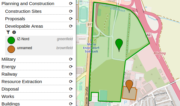
  • Developable areas: landuse=greenfield and landuse=brownfield.

Further updates:

Example of the “Developable Areas” category: Image showing a screenshot of OpenStreetBrowser with a greenfield and a brownfield highlighted

Posted by GoodClover on 23 June 2020 in English. Last updated on 4 July 2021.

The school near me was rebuilt a few years ago, and it was bugging me how it shows on maps as the old one, or both overlapped. I’ve now fully updated it on OSM :)

Update: Seems this got me into OSM! I’ve micromapped the school now, and am glad that I decided to start mapping.

Location: Willerby, East Riding of Yorkshire, Hull and East Yorkshire, England, United Kingdom

Note: this is an English version of my article in French here.

I’m a long time contributor of Mapillary and probably one of the top contributors in Wallonia. I have uploaded 59,7 k images to Mapillary, covering +1000 km. I have contributed of course with road imagery taken from my car, but also on the train and on several hundreds km of tracks and paths. While Mapillary has a good coverage in cities, it is usually poor in rural areas and I was happy to contribute on hiking trails, where I thought it has some potential for tourism applications. Beside Mapillary, I’m actively promoting OpenStreetMap as a hobby but also with my company as a GIS professional. With my colleagues or as OSM contributor, I made several trainings on OpenStreetMap to various publics: tourism agencies, urban planners, students, environmental agencies. At almost every OSM training / mapping parties, I also advocated for Mapillary, as an alternative to Google Street View, just as OSM is an alternative to Google maps. Two years ago, my colleague and I were invited as “open-source geo experts” to a meeting at the Walloon road administration to speak about the potential use of OSM and Mapillary for monitoring the 10k’s of signposts in the Walloon region (17,000 km²). So I was a also a advocate of Mapillary just like I’m a strong advocate of OSM, both in my local mapping community and professionally.

Was. Then I saw this news: Facebook acquired Mapillary. I had first mixed feelings. I took some days to think if I should stop contribute to Mapillary or not. I even still uploaded some guidepost images taken this weekend. But finally I took the decision to download all my images and delete my Mapillary account. Why?

See full entry

map note and comments June 20 2020:

Resolved note #2189641 Description

Il sentiero finisce li, per piacere rimuovete le segnaletiche e sulla mappa please. è molto pericoloso…. Created by Enzo Trekking guide about 1 month ago Resolved by jaimemd less than a minute ago

Report this note

See full entry

Location: Sanza, Salerno, Campania, Italy

8921 | Médecins Sans Frontières (MSF)

MISSING MAPS: NIZI REGION, DEMOCRATIC REPUBLIC OF CONGO

MSF is assisting in an Indoor Residual Spraying (IRS) campaign in the Nizi region in Ituri in the Democratic Republic of Congo. During this campaign insecticides will be applied on the inside of dwellings where malaria infected mosquitos rest. As a result the number of mosquitos will go down, which prevents the transition of Malaria.

Spent 1 hours mapping buildings, road and paths.

Posted by Joe Bucket on 21 June 2020 in English.

so my Grandad was born in Den Amstel and it’s where his remains are now but uppon looking there’s nothing there! in fact there’s not at all in Guyana and even less of has been mapped

So I took it upon myself to start mapping as many villages as possible along the river starting with Den Amstel due to the link with my Grandad