 OpenStreetMap

i really had fun doing this because never did i lose my interest in the past 4 weeks. the instructor was very kind and considerate and he was one of the reasons why Mapa Time is enjoyable and memorable. he was also approachable which is good since all of us were ignorant and it was our first time to encounter this session. i was eager every Thursday morning to wake up this early just to attend every session in Mapa Time.
Diary Entries in English
Recent diary entries
Posted by rachelgreen on 3 October 2019 in English.
It was a foreign experience for me for I have zero interest for geography. I honestly have no idea what the purpose of this thing was at first, I thought it was just something to kill our time with and stress us out with the early mornings instead of going to school at 1pm but honestly, I have come to the realization that this program is beneficial to the community for it focuses on locating and improving the map of remote areas in the Philippines which is closely related to CWTS. Our time was well spent, I can say with all certainty, the program is full of productivity and no time was wasted. I have learned that it is beneficial for both privileged Filipinos and the masses, the privileged can use this for their grab rides if they have a field work on remote areas for their convenience on the other hand, the masses can use this as means of knowing more about the places in the Philippines or if they are living in these remote ares, they can be certain that they are not forgotten, they are one of us and they are still in the map of the Philippines.
i found my expirience here in MAPA TIME was so interesting and fascinating. This sessions was so productive because we learned a lot here,the things I learned here are , how to draw some lines that symbolize roads , and area which is buildings. I think it is usefull for my everyday life, and maybe sometimes when I have freetime , I can share it to my friends and family. My favorite activities here is addings roads, because I found it easy and I think Im having fun with it. I can’t volunteer here because, being a BSA student was such a hard task,I spend my time studying our lessons. Its perfect , though there are some hard parts, it doesn’t need improvements in my own perceptions only.
Today I wanted to to learn how JOSM - Java OpenStreetMap Editor - differed in its features from the iD Editor available online. Its main advantages over the fantastic online editor are being able to use it offline, and its advanced features which I have yet to explore. As I become a more experienced mapper I imagine I will find good use cases for the JOSM editor.

This year I was privileged to attend my first SOTM global in Heidelberg Germany. I was granted a scholarship to attend the conference that helped me to be able to travel from Madagascar to Germany.
Before, I had attended State of the Map Africa in Kampala Uganda in 2017. It was the first international conference I have assisted. SOTM Africa had allowed me to meet new people and create a network. So I was very excited to attend SOTM 2019.
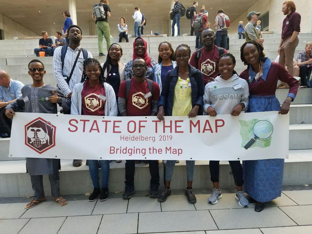
OSMF Support
I would like to say thanks to all SOTM organizers for their work. Then Dorothea Kazazi for her accompaniment during the travel preparation. She did awesome work for all of us to make sure that we got visas, the accommodation, the flights and the train tickets.
The travel guide was so helpful to travel from Frankfurt to Heidelberg.
New knowledge acquired
This year, I was invited to visit the State of the Map conference in Heidelberg as a scholar. Obviously, I would like to thank the OSM Foundation for sponsoring me. In addition to being a frequent mapper, I am also a maintainer of openstreetmap-carto (the default stylesheet on openstreetmap.org), and this role was the main reason I was visiting the conference. At the conference, I met with Paul, Christoph (who I had never met before in real life) and Andy. We had some discussions on the future of the stylesheet, including a public ‘bird of a feather session’, in which we met with other community members.
One of the things that has been on the horizon for quite a while is vector tile rendering. During the conference, we drafted an action plan for getting a vector rendering ready. Some choices need to be made: do we start from scratch, or do we continue with the current map design? Do we render the vector tiles on the client side, or do we translate vector tiles to raster tiles on the server? Which software will we use to generate the vector tiles? On the stylesheet side, some technical changes need to be made, fortunately most of which are relatively simple. Unfortunately, even with these changes made it seems that performance remains a significant limitation. By now, the first steps on the action plan already have been completed. There is still a lot of work to do (including technical challenges to solve), but we have been making progress in this area for sure.
Posted by jenjereren on 30 September 2019 in English.

Beautiful Heidelberg
I guess it’s OpenStreetMap’s way of congratulating me on my 5th year as an active contributor when my scholarship application to the HOT Summit and State of the Map both held in Heidelberg, Germany this year was accepted.
I totally over-packed (17 kgs check-in baggage for a week) in anticipation of the cold weather (8 to 18°C) because I’m a tropical girl all the way. But Heidelberg wasn’t cold at all. It was sunny, bright, and the right amount of chill in the morning. The views were gorgeous, too.

My experience at State of the Map 2019 started long before the conference itself. As promised in my post after State of the Map 2018 in Milan, I decided to get involved in the OSMF State of the Map Organizing Committee, with the main task to re-propose an Academic Track after the success of the 2018 edition.
This has meant embarking in an exciting but challenging journey started at the end of 2018, where I had again - after Milan’s experience - the pleasure to work with the other members of the Organizing Committee (Christine, Michael, Gregory and Mikel) as well as with the great Local Team from Heidelberg lead by Martin. And, above all, this has meant working with the other members of the Academic Track Scientific Committee: Yair, Peter, Levente and Godwin. We were able to attract a lot of submissions, to edit the publication of the SotM 2019 conference proceedings, to put together a high-quality academic program and to run it successfully in Heidelberg. Thanks again guys, and thanks to all the authors who made the program great with their talks and posters!
The changeset #73549546 is based on my survey of July 7, 2019, on foot.

I think the greatest opportunity you can give a mapper is put her/him in an environment of mappers. It is with great pleasure and honor to share my experience of sotm2019 in Heidelberg, Germany as a scholar. I will start by thanking the open street map foundation for giving me the opportunity to attend sotm2019 and Hot summit and also visit Germany for the first time. I will also like to thank Dorothea Kazazi for being there for us from the beginning to the end.
I promise the story start now! :)
It took me about 17hours from Banjul international Airport(Gambia) to Frankfurt airport (Germany). My journey started 2am Gambian time to 6:40pm German time. I flew from Banjul to Casablanca to Barcelona to Frankfurt. After the long flight I thought everything was over and all I needed was to lie down and rest. Suddenly! I realize I have two trains and two bus to board alone before I get to lie down, fortunately I was able to navigate and got to the hostel at one piece alone! Yay! This is the best experience ever. :).
I met and interact with lots of lovely people. I was so happy when I saw the youthmappers organization team Marcela, Patricia and Chad. I was thrilled to saw Geoffrey from Hot and Claire after exchanging calls and emails for long time. The best part was meeting Marco after silently stalking him online for his incredible job he does.
Everything was perfect and everybody was nice. I had the best roommates and Jo who took us around and translate for us. I learn so much from my fellow youthmappers and for that I am grateful.
Thank you!
Best,
Jaria
Posted by Valor Naram on 30 September 2019 in English.
Last updated on 18 January 2020.

One has an idea and finds others to step in. Together they make the world a better place. That’s Community Spirit!
What I notice when interacting with our OSM Community that we all work together on one mission: To create a sustainable highly detailed world wide map free for everyone to use and to work with, to merge with other data and to do something disruptive. Our community is very large and active around the globe. Despite our ethical, cultural and social differences we share one mission.
What I understand under the term “Community Spirit”: Working together on one mission to make the earth a better place for (almost) everyone, to change environment on a large, middle or lower scale. Community Spirit is the positive site of acting together to do something great and sustainable.
But why do we live the Community Spirit inside from the OSM Community? Because we can, because we believe in a future. Because we know our effort is important to mankind and soon awareness about our great mission will rise.
We all do great things. Humanitarian OpenStreetMap helps organisations like doctors without borders to offer medical help to people in low developed regions around the world where maps are highly outdated and not accurate enough. Mappers who don’t know each other meet in mapathons (mapping parties). Mappers in cities begin to connect to each other through chat groups, mailing list and of course local groups and they begin to fight, to fight for their interests and values. JOSM- and iD developers both are doing a great job in programming mapping tools which make mapping easier, less complicated and less frustrating, allowing not-so-computer-skilled folks to join in and participate. They all play a role in burning down barriers. The weeklyOSM Team, a bunch of great people, are bringing together information from almost all OSM societies.

Team leaders across NIGERIA had meeting organised by Mr Victor N Ndubuisi (UNIQUEMAPPER LEADER AND DIRECTOR) We discussed many issues burdening the team, result so far and way forward.
Join Zoom Meeting https://zoom.us/j/755993243
Meeting ID: 755 993 243
One tap mobile +16468769923,,755993243# US (New York) +16699006833,,755993243# US (San Jose)
Dial by your location +1 646 876 9923 US (New York) +1 669 900 6833 US (San Jose) Meeting ID: 755 993 243 Find your local number: https://zoom.us/u/abVo9w5AA
The meeting End about 12 am with satisfied Resolution .
CHUKWU Kingsley Chika KingVik Team leader LionMappersTeam Enugu Campus
The changeset #73223141 is based on my survey of June 30, 2019, on foot.
Satellite Imagery Offset
- Bing (2019): -0.16; 1.55
Posted by Reinhart Previano on 30 September 2019 in English.

Months after I announced this upgrade project I’d like to announce that Transjakarta Corridor 9 has finally become the second (and currently longest) fully-validated route (next after MRT Jakarta in Jakarta, according to Geofabrik OSM Inspector Tools.
And that also means I’m closing https://gitlab.com/reinhart1010/osm-transjakarta-v2/issues/9 as fixed.

Similar to the MRT, Corridor 9 routes have been split into two separate relations (to comply with PTV2 schema): Transjakarta Corridor 9: Pinang Ranti → Pluit (6198079) as well as Transjakarta Corridor 9: Pluit → Pinang Ranti (10042521).
If you would like to contribute in upgrading process, use the above conventions for route names:
Transjakarta Corridor <X>: <Start> → <End>
Corridor 9A
Posted by Sawan Shariar on 28 September 2019 in English.
Last updated on 29 September 2019.

It is really a challenging part to work with female for all boys institute. And our society has conservative outlook of treating gender equally.But I believe in gender equality and it is the main key of every successful achievement. Nothing can exist without mutual participation of both boys and girls. And I am decided to do that for the sustainable community. So that we regularly collaboratively works with other educational institutes and local community in our country to increase engaging new mappers, especially girls.
Challenges: we have faced
To engage female mappers always we have faced many challenges. First of all it was the primary challenge to engaging female for all boy’s institute. But we are relentlessly working to increase engaging girls beside boys.
-
Ensure a safe environment
In an under developing country it is a very crucial part is that every woman is concerned about the safe environment for her. So we have to ensure them that the mapping platform is a safe environment to the female.
I just want to get a map that show me where I am (thinking an emergency). How do that? Thank you. JMRuas

Geomatics Engineer and OSM volunteer from Nepal. Reach out to me on Twitter if you have any queries or issues with me.

On the 23rd September 2019, OSM Ireland formally signed the agreement with the OSM Foundation and official became an official chapter. You can read more about the event here
I’d like to thank all the people who have worked so hard over the past few years in putting together the necessary paperwork and jumping the many hurdles in setting up the OSM Ireland local chapter. I wish it all the best in the future and hope I can contribute in making it a roaring success!
Since 2010, the OSM contributors and developpers, we succeeded to make OpenStreetMap the De-facto Map for humanitarian responses and develop collaborations with UN agencies and NGO, and innovate to use various tools for the response, and even work with epidemiologists in difficult contexts like the Ebola outbreak in West Africa or doctors walking in remote villages of Nepal after the major earthquake in 2015.
The major OSM Responses I coordinated from 2012 offered me the opportunity to travel from Canada to various Conferences and present our results. But like many other volunteers, I have less opportunity to travel and participate to conferences from abroad. The SOTM-2019 in Heidelberg was my first participation to the international SOTM and I am very gratefull to the OSM Foundation which selected me for a scholarship.

Last September 21-23, the international conference State of the Map was held in the city of Heidelberg, in the southwest of Germany. This annual OpenStreetMap gathering attracted nearly 600 participants from around the world.
I want to start by thanking the OpenStreetMap Foundation for their support to attend the event. Their scholar program allowed many OSM collaborators to come from several continents, including me.