 OpenStreetMap

I have been asked to be the banquet speaker at the NACIS 2019 conference in Tacoma, Washington, on October 18th. The topic will be “Open Source Mapping in a Closed Society”, i.e., the cartographic work in Turkmenistan between 2015 and 2019. It is an honor to be asked to speak at the banquet, but I feel compelled to ask fellow mappers who followed my work in Turkmenistan: what points do YOU think I should be sure to cover in my presentation?
Diary Entries in English
Recent diary entries

So out of things I did not expect I’d ever do on OSM, here’s one of them.
I’ve been using OsmAnd to cache OSM data to have with me as a reference while hiking in Bosnia a couple of weeks ago. I noticed that one of the trails in the app goes through what on a paper map I had with me was marked as a suspected minefield - a remnant of the 90s war. I checked with the local mountain rescue service, and indeed they confirmed that there is a danger area there.
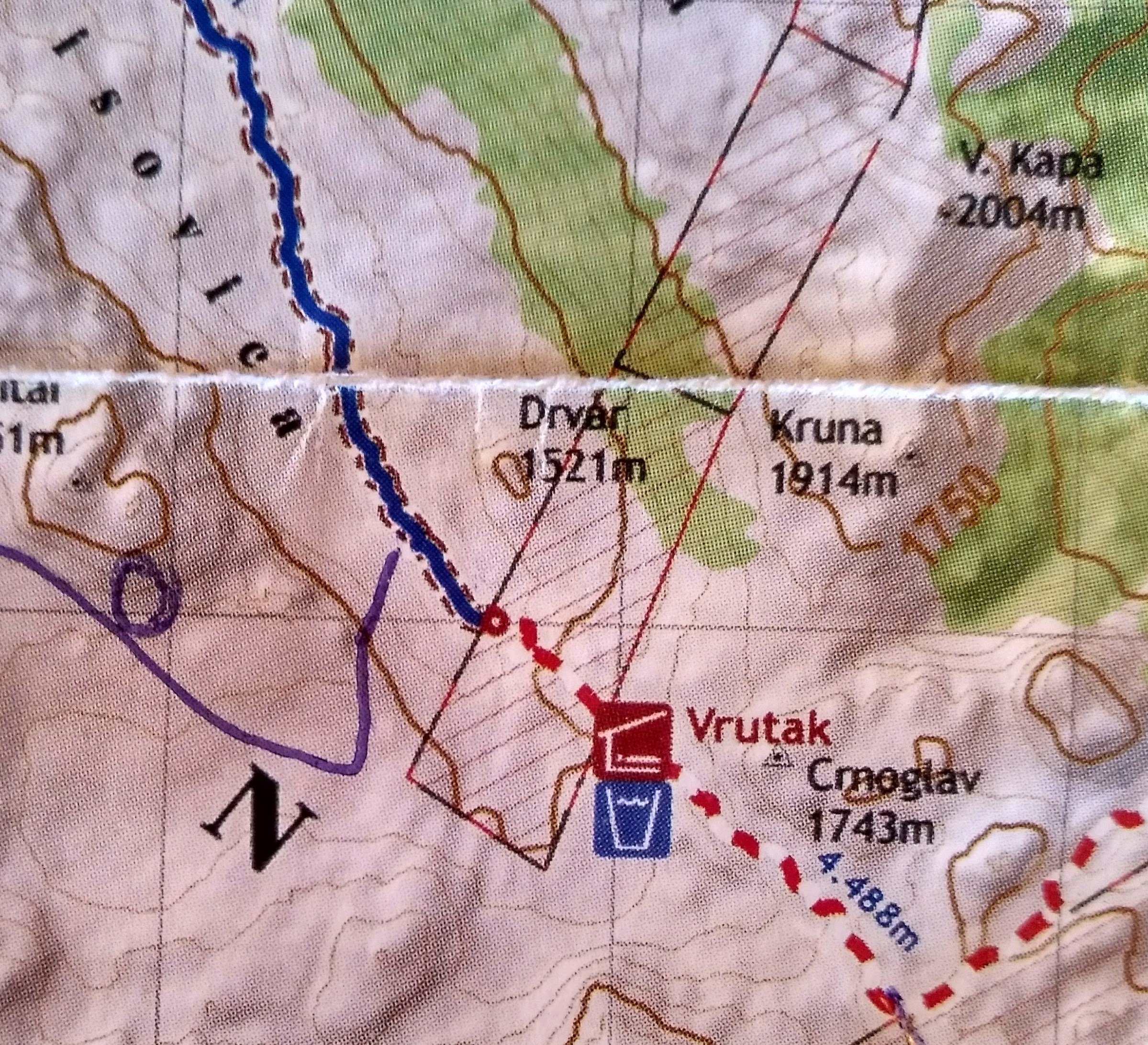
So while I do not have enough data to map out the actual extent of the suspected minefields in these mountains, and I do not want to digitize it from the paper map I have, what I can do is to correct the path that the previous hiker took - and thankfully lived long enough to map - and snap it to my own GPS trace. I followed the hiking trail markers, which I was told was the proper thing to do in the area.
I prefer to not have OSM explicitly or implicitly suggest dangerous behaviour!

Added routes in Horrues and Soignies
Added routes in Arquennes and Seneffe.
Long time since I made a diary post but today I feel like it.
Some time ago the Swedish post company did a reorganisation, where most postboxes got their collection times changed. I have been retagging some of these over time, but two days ago when I realized not all postboxes in my home town are mapped (found this one), and the next day I realized two postboxes in my area were tagged wrong (one hasn’t existed since I moved here many years ago and one has been moved changeset) I figured I’d do something about this.
Yesterday I compared the postboxes existing in OSM with the ones on Postnord’s website, and made a list
I took a class and lab at Portland State University dealing with ArcGIS. I did really well in the class and never got to do more mapping after that. I hope I can get some new skills here and meet other mappers.

Me and my Team organised a Mapping Competition which held on 9th August 2019 at University of Nigeria Enugu Campus At A109 Geoinformatics and Surveying from 12: 37pm to 4; 15pm with the total number of 14 Mappers, . the mapping competition was to map;
https://tasks.hotosm.org/project/6358#bottom #6358 - Mapathon Battle for Vulnerable Oil Spill Disaster Communities in Niger Delta Region,Nigeria-Tai LGA
Ogoniland is a major oil spill disaster vulnerable area of Nigeria,being the host communities of crude oil exploitation in the Niger Region of Nigeria.Ogoniland land consist of four local government which includes Khana Local Governemnt Area of Rivers State. Following hazardous impact and damage of ogoniland by oil Spill disaster, UNEP assessed that the environmental restoration of Ogoniland would require coordinated efforts on the part of government agencies at all levels, industry operators and communities. UNEP also presented its recommendations as a major opportunity to bring new investment, employment opportunities and a culture of cooperation to Ogoniland in addition to driving improvements in the environmental and health situation on the ground.To effectively implement the UNEP recommendations for restoration of ogoniland,there is a need for a geographic data that provides critical building footprint in the area,especially,to identify and access the vulnerable oil spill communities. Maps produced would be used by government agencies and other stakeholders working to implement UNEP report on Ogoniland restorartion.
Created by: vicksun Changeset Comment #hotosm-project-6358 #osmnigeria #uniquemappersnetwork #VictorNSunday #NGDisasterRiskReduction #ogonilandoilspill
the competition was a successful one.
Chukwu Kingsley Chika
Team leam of LionMappersTeam Enugu Campus 10/08/2019
I organised MAPATHON TRAINING WITH MY TEAM
The LionMappersTeam(LMT)Enugu Campus is an affiliate of YouthMappers Network, with the sole aim of providing members the opportunity to learn and improve their skills in the field of Geoinformatics and to create open geographic data and analysis that addresses locally defined challenges globally. It is a team of volunteers for Crowdsourced Mapping and Geographic Information provision using Openstreetmap, Citizen Science and other Geospatial Technology for research, training and response to resilient.
THE EVENT FEATURE THE FOLLOWING ACTIVITIES
-
MAPPERS WANTED CAMPAIGN RALLY
-
MAPATHON TRAINING
-
MAPATHON FOR UNIVERSITY OF NIGERIA ENUGU CAMPUS AND ITS ENVIRONS
-
FREE GIS SOFTWARE INSTALLATION
-
MOBILE MAPPING APP INSTALLATION
-
MAPPING COMPETITION
-
OSMfight.
The training held on Friday 2nd August 2019 @ A109 Surveying Class By 10am _ 4:30 Pm
Training registration link : https://docs.google.com/forms/d/e/1FAIpQLSeOQ69-_qfokQ5kMb6kl8E1e8DckbQaz8Iiw3FzcIv2HqAPjA/viewform?usp=sf_link
We map, we train Mapper We solve problems. #####TOTAL OF 42 MEMBERS WERE PRESENT
Guest:Mr Victor N Sunday
Team Mentor- LoinMappersTeam Enugu Campus
Chukwu, Kingsley Chika
*KingVik Planet
Team leader of LionMappersTeam Enugu Campus

Note: phone number, my deadname, and e-mail address have been removed by me.
Hi [removed],
The City of Philadelphia provides the GBFS information for this very purpose–to see it integrated into various useful resources for the public. The City of Philadelphia has no objections to the use of geodata derived from publicly available sources such as the GBFS feeds provided and managed by Bicycle Transit Systems, the City’s contractor in the operation of Indego.
Aaron Ritz City of Philadelphia Office of Transportation, Infrastructure, and Sustainability p. [removed] e. [removed]

Today was not fun because am actually trying to cope with the everybody buy your data scheme and guess what we are all students and there no work that pays that one is actually engaged in but lets just see how our luck will shine
It was cool mapping but network made it difficult…Thank God finally i was able to map…if no one congratulates me…i will congratulate myself…so congrats baby
Mapathon Competition still on… So many learnt.

On the eve of OpenStreetMap 15th anniversary on 9th August 2019, we organized a geo teaching session in Tagores Home Secondary School for children.

We covered topics like Geography of India, Mountains, Solar system, Rivers and Neighbourhood drawing activity. Children were amazingly active and quick to understand whatever was taught. We also came to know from their teachers that these topics are part of their academics in the next quarter and glad that this session helped them as a mock program.
my name is Esther kaakpo, i just started training on mapping with openstreetmap and so far it rocks. Go openstreetmap! I hope to learn more and improve myself. its really nice that females are part of this adventure #letgirlsmap

Last Thursday, on the first day of August, the inaugural Pista ng Mapa conference officially welcomed participants to the wide and green spaces of Foundation University in Dumaguete, Philippines. It was two-and-a-half days of mappiness for the 166 participants who gathered to celebrate Open data (especially, geodata) and Free software with local mapping communities in the Visayas region.
It was awesome to see the enthusiastic number we’re able to gather, but it was more pleasing to note their diversity. We didn’t ask for our participants’ gender in our registration, but this group photo shows that no particular gender group eclipsed the other.
 2019 Pista ng Mapa group photo. © 2019. Neyzielle Ronnicque Cadiz.
If you’ve ever been to a Filipino festival, then you may have some idea how it’s like: noisy, tummy-filling, plenty of good stuff to be had, and a great time to party with old and new friends.
Added junctions and relations around Braine-le-Comte and Steenkerque.
Today I’ve added a few Vhello relations in the area of Braine-le-Comte, Ronquières and Ecaussinnes. I’ve also tidied up the Vhello relation memberships.
Hi, my name is IB_HENSHAW. i just got started on this platform and i believe i am going to have fun mapping the Ogoni community of the Niger Delta environment. #6359
Posted by Kelechi Emele on 7 August 2019 in English.

I finally learnt how to map. GO MAPPERS!!!!!!

The OSMF board is making another survey of the OSM community and like with the last one i though i’d publish my answers. I think stating my opinion in public and this way inviting a public discussion of these matters is ultimately better than just having an asymmetric communication with the board through a survey.
How can we share your answers?
Does not really apply since i already publish the answers here.
But since i do not endorse collection of exclusive knowledge for the ruling class so to speak i chose the first option.
Are you answering as a group?
No
What is happening in your local community?
I am not really the right person to answer this on any level of locality.
What about your local community should be more widely known? What can other communities learn from yours?
One thing mapper communities in other parts of the world can see observing the German community is an example how and under what circumstances a hobby mapper community can grow organically.
Another thing is the professional OSM data user community in Germany being much more dominated by small and medium enterprises than in other parts of the world (in particular outside Europe) and how this supports technological and cartographic innovation.
Do you meet other mappers in person? Is there a local community beyond mapping?
Yes and yes.
(Note: If you want answers other than yes/no then don’t ask a yes/no question)
Are you engaged in the “global community”. If you aren’t, why not?
That’s a highly ambiguous question - both regarding what it means to be engaged and what “global community” means. There are no significant spatial limitations in my communication with others in relation to OSM. The most serious overall limitation is language which limits my active verbal communication to German and English. But i try to passively listen also to communication in other languages, in particular French, Russian and Spanish.