OpenStreetMap
richlv's Comments
| Changeset | When | Comment |
|---|---|---|
| 45555398 | is this really a park, or is it more like a grass area ? |
|
| 45552415 | hi there and thank you for your interest in openstreetmap. the footway, added in this changeset, as a bit suspect and i have removed it. sat imagery seems to show other ways between the buildings here that might be more appropriate to draw - if you have the time for this, please do improve the area, and provide mapillary.com photos so that it would be easy to verify :) |
|
| 45548308 | hi there. thank you for your interest in openstreetmap.
if it does exist, could you please install the mapillary.com application and take some photos of it ? thanks :) |
|
| 45468417 | Hi there. Thank you for the interest in OSM :)
|
|
| 45223198 | the added ATMs are unlikely to exist. please note that your edits go to a public, worldwide map dataset that is meant only for mapping real, visible things.
|
|
| 45035278 | this changeset adds a disconnected footway way/464790888 - all ways should be connected in ways entities could traverse them (cars could drive, pedestrians could walk etc) - that helps to make the map routable :) could you please check where the footway should be properly connected - and maybe also verify that all other added ways are connected properly ? thank you for all the map improvements and good luck with mapping. |
|
| 44988737 | hi there - and thank you for the map improvements :) here, and overlapping landuse was added. as it did not seem verifiable and no source was mentioned, i converted it to a simple housenumber node. please let me know if there is a source for mapping areas. |
|
| 44726872 | ...and there does not seem to be a carwash here either : node/4577009395 |
|
| 44726872 | mapillary imagery shows no buildings here node/4577009396 - is there really a cafe ? |
|
| 44603651 | hey, these footways do not seem to match the sat imagery much, and it's lightly doubtful that they are 2 metres wide... could you please take mapillary imagery of all the affected area ?
|
|
| 44702018 | thanks a lot for the map improvements - unfortunately, this footway currently overlaps two segments of the street and a building.
if there's any uncertainty on anything regarding this topic, do not hesitate to message me with any questions :) |
|
| 44632316 | highway=pedestrian already implies primary/only pedestrian usage as per highway=pedestrian - could you please clarify on this change ? |
|
| 44621485 | hey, a question on these recreational grounds - are there really areas like that ?
given that this mapping seemed to include much more than necessary (a few buildings etc), i have reverted this changeset for now. please let me know if that was wrong. |
|
| 44619025 | this bench seems a bit suspect - where is it located ? |
|
| 44552424 | hey, is operator "igors" correct here ? is that a detail static enough to be added to the public map dataset ? |
|
| 44540929 | hey, this did not look like a real camp site, so i have removed it - please let me know if that was wrong :) please note that the edits in maps.me application go in a public, worldwide database - such edits should only be used to update things that exist in the real world. if you would like to add your personal waypoints, use the "bookmarks" feature. please see http://maps.me/en/help#bookmarks for more detail. |
|
| 43960002 | there doesn't seem to be a building here - is this supposed to be the parking entrance ? in any case, the name is wrong. also, any url for "pizza daugava" ? |
|
| 29768341 | hey, what's this "Deep Tunnel" here ? |
|
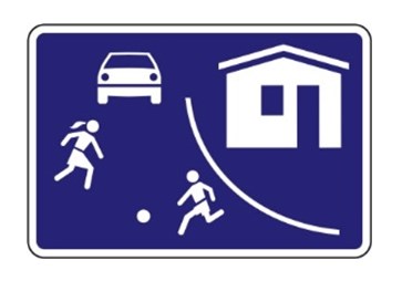
| 43315281 | thanks for the response. if it's a normal , smaller street, it's residential. if it's in an area, marked by signs like http://www.iauto.lv/_mm/i/20160106/20795_4849c138b57.jpg , it's living street.
|
|
| 43315281 | thanks a lot for the improvement - should it be marked as a "living street" ? |