OpenStreetMap
LucGommans's Comments
| Changeset | When | Comment |
|---|---|---|
| 151688518 | forgot to mention that the path I disconnected (at node/11926393518) was not there (surveyed two days ago). Did not have an opportunity to check the other end, so it might have to be pruned back further, I don't know |
|
| 151206913 | Query used:
Has false positives in terms of streets that branch off near where a street lamp was identified but that do not have street lamps mapped along them, so it needs quite a bit of manual checking |
|
| 135169248 | I just noticed you undid my change and re-tagged the whole square as a parking area again, but this is not correct. Please be aware when playing maproulette that the aerial view is not always up-to-date. I would especially ask to double check when the object you're changing comes from a recent changeset tagged as source=survey --- Mij viel net op dat je mijn wijziging ongedaan gemaakt hebt en het hele plein als parkeervak aangemerkt hebt, wat niet klopt. Let s.v.p. bij het spelen van maproulette op dat de luchtfoto's niet altijd up-to-date zijn. Ik zou vooral willen vragen om te dubbel-checken wanneer je een object wijzigt dat van een recente changeset komt die met source=survey getagged is |
|
| 150730395 | Hi, thanks for adding the path! (way/1278644243) Are you sure this is a highway=track though? That tag is meant for "minor land-access roads that are not considered part of the general-purpose road network" (see the wiki: highway=track). This path looks like it runs past buildings, so something like highway=residential might be more appropriate maybe? |
|
| 150638519 | Kein Thema, my profile says I understand German and, after all, in this international project it doesn't really matter what language is used so long as the reader(s) understand :) I've updated it (changeset/150728290) to use the meadow=pasture tag because the wiki suggests that as the most common tagging scheme these days. Thanks for raising it! |
|
| 150638519 | Ah yes, it looks like I've used the wrong tag there and it should be something like landuse=meadow + meadow=pasture? That doesn't label the use for horses, though, but indeed an equestrian area is usually round or rectangular and not this odd shape. I don't think it would be too small (~20m diameter on the semi-round west side), just the shape is odd. Does pasture meadow seem correct to you then or should it be something else? |
|
| 149706102 | Ah yes, I forget that access=x is not just about *who* is allowed to use a feature (like, the general public or customers or is it private property) but also the mother of all vehicle modes. Trying to look up what tag I should be using, it sounds like this is a common mistake (wiki page "Key:access"): "In practice, this combination is often used by mappers to modify (rather than enlarge) default values: for example, access=permissive with highway=steps is very unlikely to be traversable by a truck, whatever the tags may say." It mentions no solution other than to *not use* the access=* tag. I've removed the access=yes tag in favor of foot=yes in changeset changeset/149726215
|
|
| 146613156 | Mij valt net op dat je het huisnummer ook verwijderd hebt. Waarom niet aangeven welk huisnummer bij dit restaurant hoort? |
|
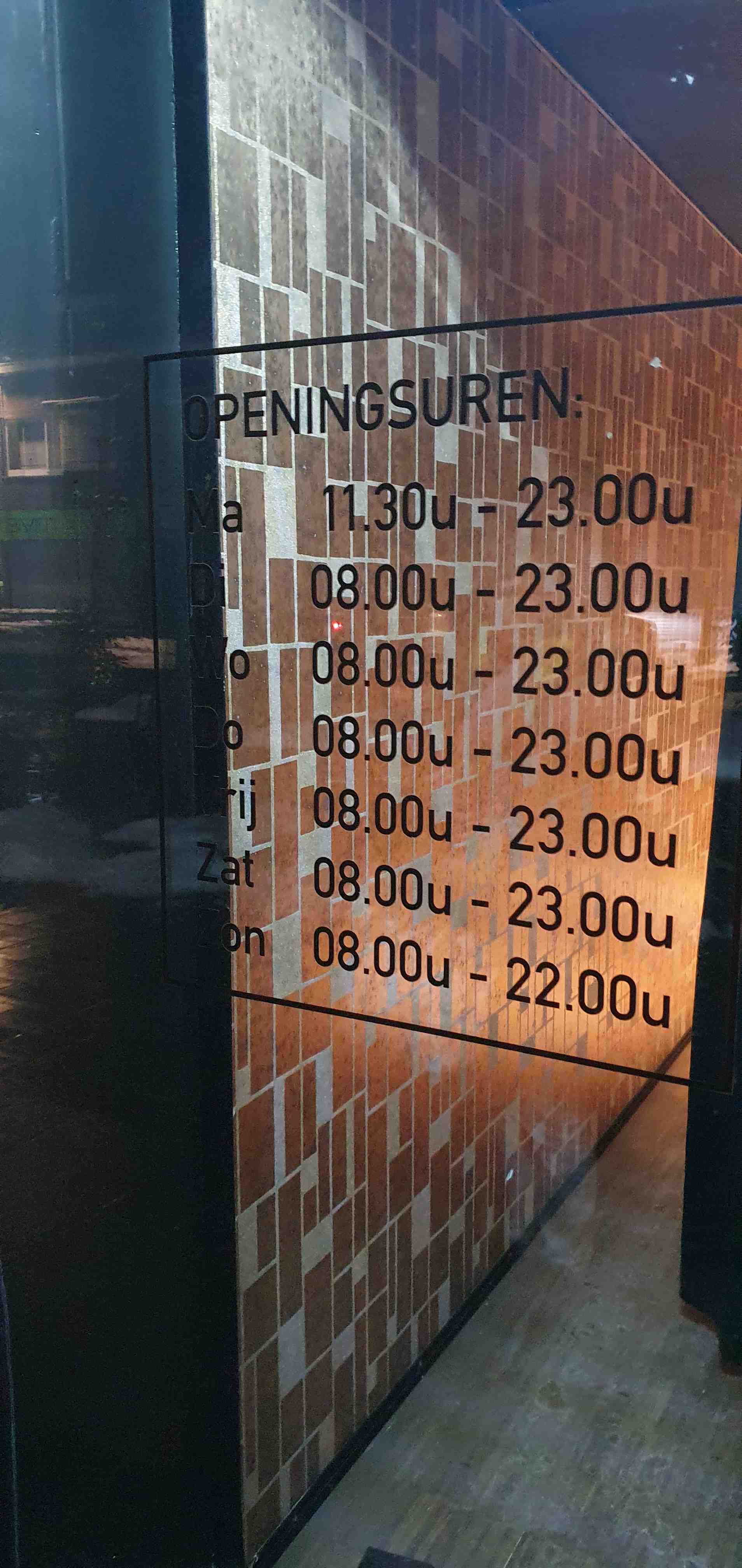
| 146613156 | Ben enkele dagen geleden ter plaatse geweest, was inderdaad erg verward dat het aan de verkeerde kant van de straat lag! Haha. Heb toen een medewerker gevraagd of ze wel nog ijscoups doen en dat bevestigde ze. Vandaar mijn tagging als ijssalon, dat is hoe we het kenden (en wat bevestigd werd) en met de ongemakkelijk hoge stoelen en kleine tafels had ik geen aanleiding te vermoeden dat het uitgegroeid was tot restaurant waar je meer dan een ijsje en een drankje nuttigt. Dat ze nu ook echt eten hebben (lunch/diner) wist ik dus niet! Die menukaart hebben we niet gekregen maar 't was ook al laat dus de keuken zal gesloten geweest zijn. Thanks voor de correctie en het toevoegen van de website, dat is altijd handig om erbij te hebben inderdaad. De openingstijden"correctie" komt overigens niet overeen met wat er ter plaatse wordt aangegeven: https://lucgommans.nl/tmp/20240119_230823-puccini.jpg
|
|
| 145031806 | Dus het wegje is er nog? Dan moet het niet verwijderd worden. Als het privé is, volstaat bijvoorbeeld access=no toevoegen aan de weg en/of de barrières/poorten |
|
| 117827256 | Hi! You added access=permit to this node node/4904045471 which has Kundenparkplatz in the name. Should this not be access=customer, or do you need to request a permit ahead of your arrival to be able to drive in? Thanks!
|
|
| 141521969 | Oh! Just checked how come I missed it, turns out it's there on osmand but only with some extreme zoom https://snipboard.io/HIWyAa.jpg :D Thanks for the hint! I have removed my duplicate |
|
| 44478795 | Hallo Thorag, I realise it has been over six years, but do you remember if the ice-age settlement next to the nature reserve "Im Korkus" was visible at the time? As in, any kind of excavation or artifacts at the site. When I was there, I only saw farmland. (Auf mein bestes Deutsch:)
Vielen Dank! |
|
| 135265538 | Sorry voor de late reactie, dingen zijn wat hektisch momenteel en ik had verwacht idd achter JOSM te moeten kruipen en me erin verdiepen om hieraan verder te werken. Maar ik zie dat je het al had opgelost! Dank :) |
|
| 136130461 | Oh, right! Thanks for noticing and fixing it! |
|
| 125898411 | Implemented in changeset/126031248 Thanks! |
|
| 110725614 | Hi Bestof, thanks for contributing to openstreetmap! I noticed that there is a sign on the sidewalk of Aachener Straße saying that the sidewalk may be used by cyclists. You tagged the road as cycleway=no (makes sense: there are no visual markings on the road), but it seems like the correct tagging for this situation would actually be cycleway=track. Cyclists can use a separated track (the sidewalk) for cycling along the Aachener Straße right after the traffic light. The tag cycleway:segregated=no can also be added to indicate that the space is shared with pedestrians (this sign is present: osm.wiki/File%3AZeichen_240_-_Gemeinsamer_Fu%C3%9F-_und_Radweg%2C_StVO_1992.svg ). Also on the L223 (way/319476907), there is a cycleway separate from the road (namely this one: way/131331611). For that, StreetComplete has a button to indicate that there is a cycleway that is separately drawn ("separat auf Karte eingezeichnet"). Hope this helps! Luc |
|
| 112826508 | Oh, sorry Andy it was indeed introduced in the version before your change. My bad! |
|
| 112826508 | Hi Andy, thanks for contributing to openstreetmap! I noticed that there is a sign on the sidewalk of Aachener Straße saying that the sidewalk may be used by cyclists. You tagged the road as cycleway=no (makes sense: there are no visual markings on the road), but it seems like the correct tagging for this situation would actually be cycleway=track. Cyclists can use a separated track (the sidewalk) for cycling along this road. The tag cycleway:segregated=no can also be added to indicate that the space is shared with pedestrians (this sign is present: osm.wiki/File%3AZeichen_240_-_Gemeinsamer_Fu%C3%9F-_und_Radweg%2C_StVO_1992.svg ). Hope this helps! Luc |
|
| 118990389 | Einige Bilder der Jetzige Situation: https://lucgommans.nl/tmp/osmpath
Also ich sehe keine Pflanzen auf dem Pfad, oder nun ja, nur was von sich selbst wächst, nicht etwas das angepflanzt aussieht für mich. Auch gibt es kein Schild das andeutet, dass man hier nicht laufen soll. Vielleicht war das Pfad geschlossen wegen die Bauarbeiten der neue Brücke. Jedoch stimme ich dir zu, dass die Wanderrouten besser auf das obere Pfad umgeleitet werden sollen. Es ist deutlich neuer und netter. Das meiste soll jetzt aktuell sein, außer den Relations: changeset/122587129 Ein zweites paar Augen, wenn du mal drüber gucken möchtest, schädet natürlich nie :) |