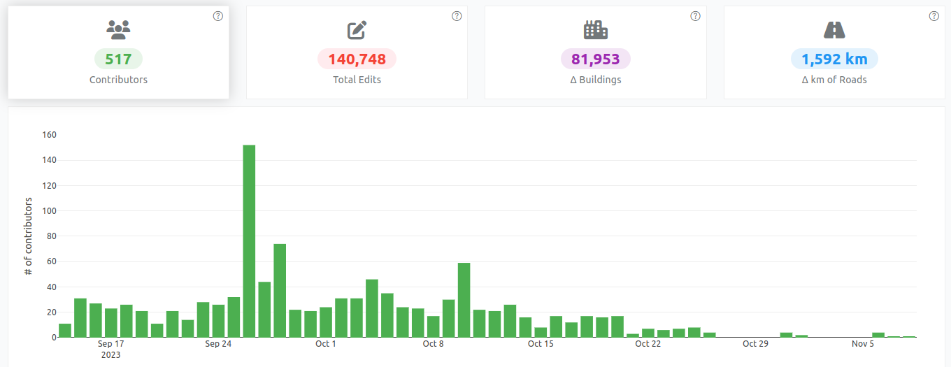
OpenStreetMap logo OpenStreetMap

Users' Diaries

Recent diary entries

workshop on how to map in the ID editor with theoretical and practical classes for beginners promoted by UMBRAOSM

See full entry

Posted by okadatsuneo on 8 December 2023 in Japanese (日本語). Last updated on 9 January 2024.

今年の話題と言えば、chatGPTですね。

日常生活では使おうと思うことはほとんどないですが、overpass-turboのクエリを作るのに使ってみたというどなたかの投稿を見て、「なるほどそういうところでも使えるのね」と思い使ってみることにしました。以来いろいろ使っていますので、簡単な紹介を。

overpass-turboのクエリを作る

簡単なものであれば、ウィザードなどを使えばすぐにできますが、ちょっと凝ったことをしようと思うと、よくわからなくなったりして。 chatGPTはoverpass-turboのクエリについても教えてくれました。

例えば、「値が日本語になっているタグを検索するにはどうしたら良いか?」 一回で望むような回答にならなくても、何回か聞き方を変えるなどして答えがわかりました。

例えば、’cuisine’の場合は nwr["cuisine"~"[ぁ-んァ-ン一-龯]"] と書きます。このカッコ内の文字の範囲が日本語の範囲だそうです。

これで値が日本語になっているオブジェクトを検索できました。 これで検索して、”cuisine:ja”に変更したり、”cuisine”の方は英字の値に書き換えたりしてみました。(とりあえず西日本のみ)

プログラムを書く

GTFSやGBFSのファイルをOSMにインポートするために、適切なデータ形式に変換する必要があるのですが、手作業ではとてもじゃないけど無理ですね。

普段はプログラミングに縁がなく素人の自分は、昨年まではネットをいろいろ検索してpythonやGoogle Colaboratoryの使い方を調べながらなんとか少しずつ書いていたのですが、今年からはだいぶん楽になりました。

「こういうデータでこういう処理をしたい」とchatGPTに聞けば、すぐにコードを提示してくれます。 途中までコードを書いてこの先の処理を作りたい時は、途中までのコードとそこから先にやりたいことを書けば、教えてくれます。 自分のデータに合わせてコードを提示してくれるので、非常にわかりやすいですね。

一通り動くコードができあがったら、コード全体をコピペして、「改善すべき箇所があれば教えて下さい」と問えば、より適切なモジュールを使った形や汎用的な書き方を教えてくれます。

これで、素人でも比較的簡単にコードを書くことができるようになりました。

英文作成

インポートの手順の中でwikiページを作成したり、import-MLやコミュニティフォーラムでアナウンスする必要があるので、どうしても英語がついて回ります。

今まではGoogle翻訳などで、日本文を英文に翻訳したりしてなんとか凌いできましたが、英文としてはどうしてもブツ切りで稚拙な感じがするけど仕方ないなと思っていました。

chatGPTを使えば、英文が一通りできた時にそれをコピペして「直すべきところがあれば教えて」と問えば、より自然で文法的にも修正された英文を提示してくれます。

もちろん全部を鵜呑みにすることはできなくて、ちょっと言い回しがおかしいなと思うところは採用しなかったりしますが、これで英文の作成もより良いものになります。

以上、簡単な使用例でした。

Posted by ovruni on 8 December 2023 in Spanish (Español).

Han pasado 15 años desde que comencé a aportar en este proyecto (comencé en el 2008), en un inicio el mapa en Perú solamente tenía unas cuantas calles de la capital. Durante estos años he conocido a algunos mapeadores que posteriormente dejaron de tener actividad.

Durante estos años también he aportado en la organización de jornadas de mapeo, organización de eventos locales y latinoamericanos como el SotM LatAm 2017, evento sobre Gestión popular de riesgos de desastres y OpenStreetMap LATAM 2022, eventos organizados por el gobierno peruano como el Mapatón 2023 del CONIDA. Además de hacer traducciones de la web de OSM y el software JOSM (yo soy el que traducía los mensajes que salen al abrir JOSM), también de la documentación en la wiki de OSM.

Además como parte de la organización del grupo de usuarios en Perú también estuve viendo la gestión de la web, grupo de telegram, sala de matrix, gestor de tareas, lista de correos, etc.

Desde unos años atrás también he estado revisando y corrigiendo de manera diaria las ediciones realizadas en Perú y revirtiendo vandalismo que se realizaba en Perú o en áreas mas grandes que involucraban a Perú (como el vandalismo a nombres en ruso que hicieron en Latinoamérica hace unos meses). Sin embargo desde hace unos meses atrás estas actividades de vez en cuando me hacían cuestionarme si estaba dedicando demasiada parte de mi tiempo al proyecto. Pero no fue hasta hace un mes en que esta idea tomo mas fuerza luego de obtener una respuesta de parte de un miembro del DWG a un ultimo reporte, en el que se menciona que no se puede revisar los enlaces de mi reporte por ser demasiados (a mi también me tomó demasiado tiempo tener que hacer esa revisión para generar el reporte) y que finalmente todo el reporte quede aparentemente en la nada y el usuario reportado siguió como si nada.

See full entry

Posted by spwoodcock on 7 December 2023 in English. Last updated on 21 February 2024.

To GDAL or not to GDAL

GDAL is an incredible geospatial library and underpins so much of what we do, including our databases (PostGIS).

However, sometimes it might be a bit heavyweight for what we are trying to achieve.

Installing it as a base system dependency inevitably installs everything - there are no options.

image

Install size is especially important when building container images, that we want to be as small as possible for distribution.

GDAL in PostGIS

PostGIS uses GDAL for most of it’s geospatial processing, including reading and writing various geospatial file formats.

FMTM is starting to use FlatGeobuf format for various purposes (OSM data extracts, storing submissions).

It also uses a PostGIS database as part of the software stack.

So today I thought: why not just use the geospatial processing built into PostGIS for reading and writing flatgeobuf data?

The solution was surprisingly painless!

Database Access

First we need a way to access the database.

See full entry

Location: Kuala Lumpur City Centre (KLCC), Bukit Bintang, Kuala Lumpur, Malaysia

Seit Samstag können die stimmberechtigten Mitglieder der OpenStreetMap Foundation über drei der sieben Vorstandsposten entscheiden. Informationen zu den Kandidaten findet ihr im OSM-Wiki.

Wahlverfahren

Gewählt wird nach dem Single-Transferable-Vote-Verfahren. Das heißt, die Wähler ordnen die Kandidaten nach ihrer persönlichen Präferenz. In jeder Auszählungsrunde wird geprüft, welcher Kandidat schon mehr Stimmen hat, als anhand des Quorums erforderlich wären. Falls es einen gibt, gilt er direkt als gewählt. Falls kein Kandidat genügend Stimmen hat, wird der Kandidat mit den wenigsten Stimmen gestrichen und die Stimmen seiner Wähler auf die Zweitstimmen verteilt. Es lohnt sich nicht entgegen der persönlichen Präferenz abzustimmen, weil der Vorzugskandidat geringe Chancen hat, wie es etwa beim Mehrheitswahlrecht oder einem Verhältniswahlrecht mit Fünf-Prozent-Hürde der Fall wäre. Es hat auch keinen Nutzen, die euch unliebsten Kandidaten gar nicht auf dem Stimmzettel einzutragen.

Bei der OSMF wählen die Mitglieder keine Personen in bestimmte Ämter (Vorsitzender, Stellvertreter, Finanzvorstand, Schriftführer, Beisitzer), sondern nur Personen in das “Board”. Die Zuständigkeiten werden in der ersten Sitzung festgelegt.

Der Vorstand ist kein Parlament, auch wenn mittlerweile viele Entscheidungen nur mehrheitlich, nicht einstimmig getroffen werden. Die Vorstände sind aufgrund des britischen Companies Act nicht ihrem Gewissen oder ihrem Wählerklientel verpflichtet, sondern dem Wohle des “Unternehmens”. In der Praxis müssen die Personen zusammenarbeiten können. Einzelne Vorstände, deren Interessensgebiete wenig mit den tatsächlichen Bedürfnissen und Nöten der OSMF zu tun haben, behindern die produktive Arbeit. Zudem müssen sie müssen dazu fähig sein, ehrenamtlich ein nicht geringes Zeitbudget auf die Vorstandsarbeit zu verwenden.

Meiner Meinung nach sind folgende Themen in den kommenden Jahren für die OSMF von Bedeutung (unsortierte Liste):

See full entry

Posted by jcr83 on 5 December 2023 in English. Last updated on 7 January 2024.

Version française

Introduction

Many paths, tracks and even small streets are missing from OSM. And yet, these paths are often used by Strava users, who upload their traces there. So I thought it would be interesting to use these data to improve OSM.

That’s why I wrote a Python program which, by analyzing Strava data, is able to detect missing paths in OSM, then generate files to create MapRoulette challenges so that each missing path can be added to OSM.

What is Strava?

According to Wikipedia, Strava is a website and mobile application used to record sports activities via GPS. Its members use devices such as a GPS watch or smartphone to record their running activities, and send these to Strava. Currently (2023), there are over 100 million members.

Strava heat maps

On its website, Strava publishes a heat map showing the aggregation of all its users’ tracks.

Example: Strava heatmap example

The more a route is ridden, the brighter its track appears on the heatmap.

See full entry

Posted by Eden Oluigbo on 5 December 2023 in English. Last updated on 10 December 2023.

👋🏼 Hello and welcome to my blog space where I share everything about my journey with Outreachy, HOTOSM and more. Thank you for joining me on this exciting journey! I am very excited to be part of the Outreachy program and If you’re interested in knowing the rest of my story, which I am willing to share it all :), please subscribe to my posts, so you get notified every time I publish a blog on my journey. Just like everything that ever existed, there’s always a beginning. So let’s zoom🔍 out a little bit to where it all began 😊.

image that says "the journey is on"

Introduction

My name is Eden Oluigbo. I am a full-stack developer, artist and creator living in Abuja, Nigeria. I'm an open-source advocate and love contributing to the improvement of open source software. I started an active contribution to open-source projects in 2022. I joined different communities, made contributions and got PR merges (that excitement of having your PR merged never gets old haha😁).

Why Outreachy?

See full entry

Posted by nukeador on 5 December 2023 in English. Last updated on 6 December 2023.

This is a cross post from the HOTOSM blog.

As Community Strategist and Research Lead at HOT, I would like to take a closer look with you all at the evolving landscape of OpenStreetMap (OSM) contributors, especially in the context of local knowledge and its crucial role in our mapping efforts.

Summary

Our recent study reveals a trend in local knowledge contributions in OpenStreetMap: a small but dedicated number of local mappers, making up just about 3% of contributors who are in the area mapping, is responsible for approximately 75% of the detailed mapping contributions.

This significant finding underscores the vital role of local knowledge and expertise in creating comprehensive and accurate maps, especially in humanitarian and unmapped/under-mapped regions. Despite a general decline in new OSM contributors, the impact of this core group of local mappers remains profound and indispensable for the future of the project.

We would like to engage researchers and mapping communities to unveil what are the implications of these numbers and the opportunities to use them to better support mappers.

The Spark of Inquiry: Simon Poole’s Analysis

Our journey began with Simon Poole’s important observation: a 20% drop in new OSM contributors. This sparked intense discussions within our team and motivated us to investigate further, particularly focusing on regions where HOT is actively involved.

See full entry

Posted by joyceeemaeee on 4 December 2023 in English.

Another year, another Pista ng Mapa 2023 in Tacloban City!

Hosted by UP Visayas Tacloban YouthMappers, it’s a gathering celebrating open mapping, data, and an unforgettable journey. I am grateful to the organizing team for the scholarship grant and the chance to present. Thank you, UP Tacloban Youthmappers, for the warm welcome and for keeping our surroundings pristine.

The conference was a three-day journey packed with eye-opening lightning talks. From Leanne Caye D. Obispo’s “Data: A Story to Tell” to Sir Denrazir Atara’s spatial analysis of tree species, each session was a revelation. Erika Del Rosario Pauline Jen Madrona’s drone training and Oriel Jay Ibañez’s insights on community development through drone imaging were inspiring. Sir Ben Hur Pintor’s discourse on data management and Ms. Dinnah Feye Andal’s introduction to Mapillary were eye-openers. And oh, the endless field trip—such a blast! where I can say I shall return to Tacloban

Meeting old friends, making new ones on social nights, connecting with mentors again like Sir Mikko Tamura, Ms. Feye Andal, Leigh Lunas, Sir Ben Hur, and Sir Aimon, and connecting with the local YouthMappers chapters were a highlight! This was my 2nd Pista ng Mapa 2023, a great adventure with a small team with Dora (Me), yet the knowledge gained, networks built, and friendships forged were beyond measure. Here’s to hoping next year brings even more from our chapter.

I look forward to creating new memories and deepening my mapping passion at the next Pista ng Mapa (also SotM, manifesting!). Huge thanks to everyone who made this event an unforgettable experience!

Location: Brgy. 2, Downtown, Tacloban, Eastern Visayas, 6500, Philippines
Posted by KAWAMALA on 4 December 2023 in English. Last updated on 23 January 2024.

Thank you

GISDAY2023

Asante sana

Your participation in 2023 GIS Day Conference was hugely appreciated

"Geospatial technology stands as a cornerstone for fostering a robust digital economy in Tanzania,serving as a catalyst for achieving sustainable development that will secure a prosperous future for forthcoming"

Dr. Moses Nkundwe Mwasaga, DG ICT Commission

Throughout the conference, we witnessed over 200+ participants gathered at the Tanzania Commission for Science and Technology (COSTECH) in Dar es Salaam to exchange knowledge and participate in dialogue on utilising geospatial technology for sustainable development in Tanzania.

The conference brought together geospatial enthusiasts, leaders, and practitioners across industries, the private and public sector, academia, and civil society organizations to promote changes that can be made at the community, producer, and government levels for sustainable development.

Engaged participants included:

See full entry

Location: University Residential Houses, Kijitonyama, Kinondoni Municipal, Dar es-Salaam, Coastal Zone, 25195, Tanzania

Где находится: г. Владимир, на расстоянии 300 м к западу от пересечения ул. Мира и Октябрьского пр-та, 50 м к югу от ул. Мира.

Описание: Объект природы “Источник” – стабильный и концентрированный сброс подземных вод. Относится к группе вод нисходящего типа. Примерный расход равен 0,2 л/сек. Недавно источник был благоустроен. В процессе облагораживания было установлено в качестве каптажной камеры железобетонное кольцо. Оно выделяется на 0,8 м над поверхностью и защищено железной крышкой. Для защиты воды от загрязнений была установлена металлическая труба. Для стекания воды был поставлен на высоте 20 см от трубы специальный резервуар, под которым выложен на деревянный пол. Возле источника установлены 2 беседки – одна с четырехскатной крышей, покрытой металлочерепицей, вторая - с двускатной крышей и удобной скамьей для комфортного отдыха. Вода из источника образует небольшой ручей, который спускается вниз по склону. Доступы к источнику оборудованы широкой бетонной лестницей с улицы Мира, имеется грунтовая тропа, с последующим прохождением по деревянным мосткам. Для местных жителей прилегающих районов Владимира это место является источником питьевой воды.

Основной целью обустройство природного памятника является сохранение уникального гидрогеологического объекта, являющимся источником питьевой воды для горожан. Еще одним приоритетом проекта считается поддержание гидрологического режима территории.

Факторы, представляющие угрозу для родника на улице Мира

See full entry

Location: Ленинский район, Владимир, городской округ Владимир, Владимирская область, Центральный федеральный округ, 600000, Россия
Posted by Thelone1986 on 3 December 2023 in French (Français).

Une semaine calme sur OSM avec seulement quelques petits updates de micromapping vraiment. C’est toujours un objectif actuel, en tout cas pour certains coins de Seraing, mais le temps libre m’a fait un peu défaut et donc c’est tout ce que j’ai fait.

Au niveau des vidéos, j’ai également été un peu plus lent avec seulement deux nouvelles cette semaine :

Ce randonneur se balade sur le tracé du tram vicinal 713 à Seraing et part sur une tangente - Deuxième partie de la randonnée du 19 novembre où je me balade sur un ancien tracé de tram vicinal… et m’énerve un peu à cause d’un trio de motards que je rencontre par trois fois ce jour-là

Ce cycliste part sur les traces de l’ancien tram vicinal 456 à Seraing (et Neupré un tout petit peu) - Une “vieille” vidéo ici (elle date d’avril 2023) où je prends le même tracé en VTT (et en entier) jusqu’au “finish” devant une barrière à Neupré. Je mentionne cette vidéo ici vu que ça a aussi un rapport avec la dernière qui est…

Ce mappeur OpenStreetMap fait un débriefing de sa dernière vidéo et explique sa logique pour mapper - Le contenu est dans le titre, mais j’explique pourquoi j’ai mappé une partie du vicinal 713 d’une certaine manière sur OSM, ce que je ferais si je me décidais à faire le Bois de la Neuville un jour, et aussi pourquoi j’ai mappé un chemin à Rotheux différemment que le tronçon du 713 malgré une situation similaire. Je m’attends à quelques critiques ici pour être honnête, mais je voulais un peu exposer ma logique dans cette vidéo

Une semaine un peu plus light donc. Il reste deux vidéos “live” de cette randonnée qui devraient être plus simples à éditer, et la semaine qui vient semble plus calme donc je devrais reprendre un peu plus mon micromapping sur OSM.

A+

Location: La Boverie, Seraing, Liège, Wallonie, 4100, Belgique