I am Bayazid Ahmed. I am from Bangladesh. I am studying at the Eastern University of Bangladesh. I am a joint secretary of our chapter, YouthMappers at Eastern University.
Users' Diaries
Recent diary entries
A Step Forward in Mapping Together
Hello, OpenStreetMap Community!
We at Mapilio are thrilled to announce a significant update that’s been in the works for some time now — the integration of our imagery layers into OpenStreetMap, available through the iD editor. This collaboration represents a milestone in our ongoing commitment to enhancing the mapping experience for everyone in the OSM community.
 ## Why This Matters
The power of OpenStreetMap lies in its community and the collective effort to create the most detailed, open-source map of the world. By integrating our high-quality imagery layers from Mapilio, we aim to empower mappers with even more tools to enhance accuracy and detail in their mapping endeavors.
Collaboration at Its Best
♪♫ When Girls Just Want To Have Fun ♫♪
On March 23, 2024, as part of the Women’s Month celebration, the Viscan YouthMappers organization conducted a mapping activity titled “MapaBabae: When Girls Just Wanna Have Fun Mapping the Streets Using Mapillary.” This initiative aimed to pave the way for women’s empowerment through mapping, celebrate the contributions of women in the field of mapping, and inspire each other.

It started with an introduction of mine about what the Mapillary is all about which will be used by us by updating the streets of our University Campus that hasn’t been captured last mapillary event. Sharing that Mapillary is a collaborative street-level imagery platform wherein participants in MapaBabae are able to document their journeys and highlight points of interest, and share their stories regarding about this acivity. At its core, MapaBabae is about more than just mapping streets; it’s about creating a community where women feel seen, heard, and valued.
Posted by SeverinGeo on 28 March 2024 in English.
English below / Português abaixo
Il y a presque cinq ans, lors du SotM 2019 de Heidelberg, j’avais présenté une analyse critique du concept de mapathon sous le titre de « Mapathon Mapathon Mapathon ». L’historique du concept rappelait combien il s’agissait au début de projets menés sur plusieurs jours, pour devenir ensuite ce que j’ai appelé le mapathon 2.0, une action de cartographie collaborative sur imagerie dans une durée qui s’étend rarement au-delà de deux ou trois heures, avec des objectifs variables, au-delà de la donnée produite : promotion du projet OSM, engagement ou renforcement communautaire. communication sur un projet ou la structure organisatrice de l’événement…
Je ne pense pas que ce format 2.0 ait évolué depuis, mais il y a un aspect que j’avais identifié à l’époque sans pour autant le développer : le mapathon 2.0 en tant que forme privilégiée pour former de nouveaux contributeurs et contributrices OSM.
On pourrait penser qu’il ne s’agit pas d’une rupture avec le passé, mais plutôt d’une suite assez logique de la manière de former de nouvelles personnes à OSM avant l’avènement des smartphones, qui dans mon souvenir se sont démocratisés au Sud à partir de 2015 environ (voir ce graphique de l’International Telecommunication Union). Toute contribution dans OSM se faisait alors forcément en salle, vu que les moyens de collecte sur le terrain (terminaux GNSS classiques type Garmin Etrex ou cartes imprimées de type Walking Papers ou Field Papers) nécessitaient une reprise des données brutes du terrain sur ordinateur avec son éditeur préféré.
The Magdalen Islands (Îles-de-la-Madeleine) are an archipelago located in the center of the Gulf of Saint Lawrence (Eastern Canada). The heart of the archipelago is made up of seven rocky islands connected by long sand barriers, sand spits, dunes, and salt marshes. Including internal lagoons, the islands cover about 330 square km. The archipelago is sparsely populated and counts about 12K permanent inhabitants.
In June 2023, OSM describes the islands’ coastline, road network, some trails as well as some human and natural features. Overall, the islands were mapped using about 56K nodes, 5K ways, and 116 relations (Figure 1).
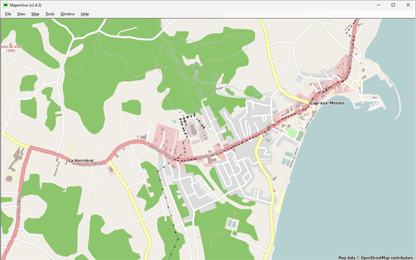 Figure 1: Cap-aux-Meules, before starting the project—Historical OSM data as of June 30, 2023, on Maperitive.
Posted by Supaplex on 28 March 2024 in Chinese (Taiwan) (中文(台灣)).
藉由 TomTom 台灣辦公室牽線,由他們成大測量系系友去洽談,再加上 OpenStreetMap Taiwan 申請社群的 Tasking Manager 管理權限,能夠新增適合本地進行的專案,才有此次的機會前往成大進行 OpenStreetMap 圖客工作坊,並且用 Tasking Manager 來分配繪製台灣本地圖資。
- 專案連結:https://tasks.hotosm.org/projects/16316
- 簡報連結:https://hackmd.io/@osm-tw/HJJqv7HC6#
- OSMCha 連結:學生的編輯監控
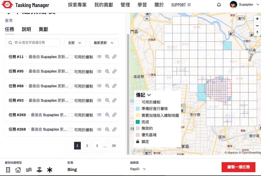 ▲ Tasking Manager 的專案,本次要繪製的範圍台南學甲區
本次成大圖客松截至 3/26 共計 107 個編輯變動,29 個工作人員的編輯變動,3個社群朋友的編輯變動,22 位學生投入編輯總共有 75 個編輯變動,設定繪製目標的建築,總共畫出 369 棟。
學生實際動手之後,投入狀況還不錯,先介紹他們 OpenStreetMap 的基礎知識,再來知道資料怎麼產生,最後自己動手來做。由於整體時間只有一個半小時,並不太夠,除非選到比較郊區的任務,不然連一塊當中的建築都畫不完。
這次邀請方是成大測量系,與老師聊天時,他們蠻常運用 OpenStreetMap 資料,然後社群部分跟早年的 OpenStreetMap 台灣社群活躍者 Dongpo 比較熟,與 OpenStreetMap 相關認識是從 Dongpo 來的,也蠻合理的,因為 Dongpo 是相同空間資訊學科背景的。
not been lazy but busy with so many other things, but got suddenly a new JOSM install fit for use an got catched for a few hours by now: I read some old wiki docs from 2008/09 i. e. the pilot work for Karlsruhe house number tagging schema in our town, added a few obviously missing objects, peeked into current issues nearby on Osmose did some corrections - all that feels good, this might even start a new series of contributions. :-)
Overpass Turbo Query
10 examples of overpass queries to be used in Openstreetmap

Exemplos OVERPASS
• PTo query objects in another municipality, use this part of the query in red to change the name of the Municipality and state and you will have a search for objects in your location. • for a search by neighborhood, enter the name of the neighborhood and the city of the search
“Exemplo”
[out:json][timeout:25]; // fetch area “Terceira” to search in {{geocodeArea:campos dos goytacazes,rj}}->.searchArea; // gather results
Consulta de Ilha
[out:json][timeout:180]; area [‘ISO3166-2’ = ‘BR-PA’][admin_level=4] (area.a) -> .uf; nwr [place~”islet|island|archipelago”][name] (area.uf); out geom;
Consulta de Escolas em Município
Posted by German C on 26 March 2024 in Spanish (Español).

En su pueblo tal vez ya tenga:
[deleted]
What is this why is there a diary
Hi again,
It’s just 2 days before this diary post was published, and I’m very happy to announce that I will start proposing tags again. I already have exciting ideas and hopefully the community approves them.
EDIT: Next proposal will hopefully come tomorrow or this week, stay tuned!
Ewrt1
Posted by EkMapa on 24 March 2024 in Spanish (Español).

-
Cullera:
· Crear áreas de casas en la urbanización Cullera Park. (+58 edificios) · Crear áreas de casas en la urbanización Bonavista. (+132 edificios) · Crear áreas de edificios en parte Noroeste de la ciudad. (+88 edificios) · Crear áreas de edificios en Cullera centro. (+123 edificios) -
Bilbao:
 · En el parque de Amezola (+ 1 camino)
 · En el parque de Amezola (+ 6 áreas verdes)
Posted by yvonnepaje on 24 March 2024 in English.
Shape my future with OSM Mapping and Youthmappers: Post Graduation Blog
A few months after my graduation, I find myself questioning how prepared I am to face the real world. Will the knowledge I acquired in school, particularly regarding organizational management, truly benefit me? Or could OSM mapping play a pivotal role in shaping my career path?
But how exactly do OSM mapping and YouthMappers influence career decisions?
Through mapping activities, I've gained critical thinking, problem-solving, and collaborative skills—qualities highly sought after in today's job market. Little did I anticipate that within these communities, I would uncover aspects of myself previously concealed. Leadership, once abstract, found a nurturing environment within the supportive ecosystem of YouthMappers. It was here that I discovered my capacity to lead, inspire, and effect change.
YouthMappers became my haven for personal development more than merely a platform. With every mapping project, my confidence increased. Although it was scary at first, public speaking became a skill I developed whenever I got the chance. Our community's response to our influence extended well beyond the boundaries of our maps, creating a lasting impression on people's emotions.
These days, certificates appear on my résumé as credentials as well as proof of my experience. They talk about the hours spent creating, learning, and working together. With the support of mentors and the friendship of other mappers, I learned things that went beyond what was found in textbooks.
Today, I stand not just as a graduate, but as a leader forged in the crucible of YouthMappers. I have the privilege to educate others on utilizing OSM mapping for change. Once reticent, my voice now brims with the fervor of someone who has experienced the potency of unity in action.

Welcome to my second OpenStreetMap NextGen development diary. I am ready to highlight this week’s progress — and there was a lot 👷!
You can subscribe to my diary updates on RSS here:
osm.org/user/NorthCrab/diary/rss
Finished Settings Page
Last week I showcased initial progress on the new settings page for OpenStreetMap. This week, I’ve finished it. Here’s what’s new. Keep in mind that if you believe some features should be done differently, there will be a period of public testing where I’ll collect this kind of feedback 😉.
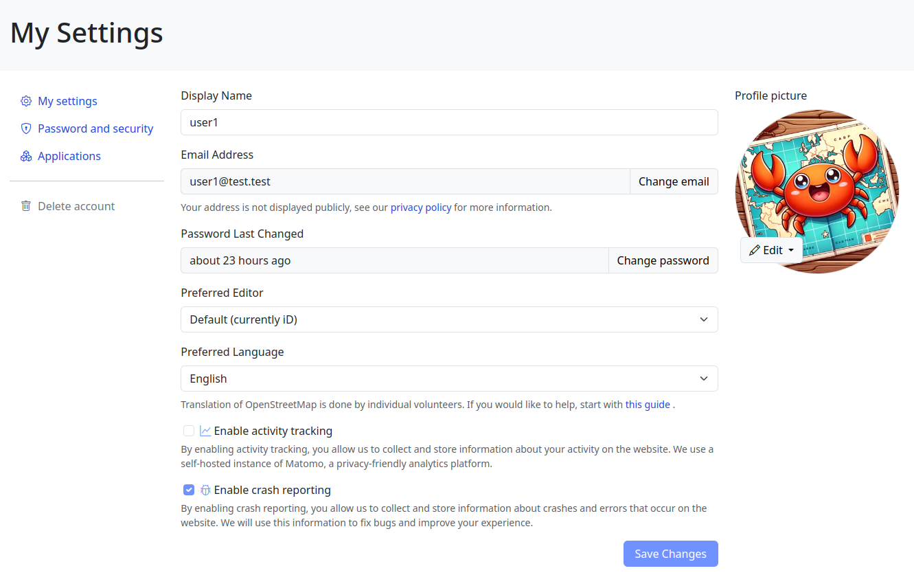
Click here to view it in full screen.
Aside from the improved layout, I’ve introduced two notable changes. First, the application language selection has been redesigned; it’s now a simple dropdown selector. I believe the current system (where you input locale names by hand) is difficult for less technical people to understand, and I want to make the website more accessible to everyone!
Posted by Kanoxitu_zh on 22 March 2024 in Chinese (China) (中文(中国大陆)).
求助,今天补充地图的时候网络卡了,结果回来的时候就变成这样了,右键显示的都是[missing “en.javascripts什么的,重启清理数据也没用,只能换其他游览器,有没有什么别的处理方法。 图:https://ibb.co/S0KVzp8
Posted by sannoization on 22 March 2024 in Russian (Русский).
Last updated on 14 August 2024.
Всем привет, занимаюсь маппингом с февраля, а все началось с поста Андрея Ситника в Мастодоне
Поставил себе streetComplete и понеслась
Что нужно чтобы вкатиться в маппинг с 0
Карты и редактирование
- StreetComplete — Приложение с квестами для OSM. Самый простой способ редактировать данные, пока гуляешь до магазина / работы / парикмахерской, едешь на другой конец города. Также можно записывать GPS-треки. Пока есть только версия для Android, но разработчики уже занимаются версией для iOS
- EveryDoor — альтернатива StreetComplete для iOS и Android. Без квестов, я бы назвал это облегченным вариантом Vespucci, однако его удобно использовать для доработки объектов, добавленных в StreetComplete (т.к. он содержит все теги и значения с OSM) и для проверки уже замапленных объектов.
- OpenStop — приложение для редактирования информации об остановках
- Organic Maps — оффлайн карты от создателей maps.me с возможностью редактирования, в последнем релизе (неделя с 18 по 24 марта 2024 года) в android-версии вернули авторизацию через OSM-аккаунт. В нём можно смотреть отрисовку крыш зданий.
- сам этот сайт, на котором я пишу эту запись в дневнике — редактор iD, ля некоторой advanced-доработки объектов
- OsmAnd — чтобы смотреть разные наложения карт. В нём тоже можно редактировать объекты, но не так удобно, как в StreetComplete.
- OSMTracker — чтобы писать GPS-треки для дальнейшего маппинга дорожек. Пока пишешь трек, можно добавить текстовые заметки, голосовые заметки, фотографии и объекты.
Треки с зеркалами
- Mapilio (для тех кто в РФ) — чтобы создавать зеркала, которые интегрируются с OSM. В РФ очень мало пользователей, в Нижнем Новгороде кроме меня никто треков с зеркалами не писал, в Москве навскидку треков <50. Проект существует недавно, развивается, планируют добавить поддержку панорам с дронов.
- Mapillary, KartaView (для тех кто не в рф) — тоже чтобы создавать зеркала, интегрируются в OSM, из этих сервисов треков с зеркалами больше всего.
Advanced

Participants shaded by umbrellas, to protect them from the sun, while collecting fresh geodata with FieldPapers. UP Mindanao Campus, Davao City. Photo shared by UPMinYouthMappers in their SNS post.
While visiting the family down south, I had a chance to join UP Mindanao’s own chapter, UPMin YouthMappers while their College (of Science & Maths) was celebrating Pi Day. The coordinator asked if I have any preference for the name of the activity we had in mind, and I suggested Map-Pi Day.
Posted by ZekOwney on 21 March 2024 in French (Français).
Last updated on 16 February 2026.

Mars 2024.
Bientôt un an (11 mois) que j’use ma souris sur OSM… Et déformation professionnelle oblige, je reportais déjà quelques stations d’épuration suite aux études réalisées au boulot. Puis j’ai commencé à corriger/compléter via Osmose.
Voyant le Calvados (14) quasiment vide de corrections, j’ai cru que quelqu’un avait déjà fait le taf…
Et bien oui ! Mais très peu d’installations dessinées, juste des emprises. Du coup consultation du jeu de données Sandre pour les installations de traitement des eaux usées.
Il existe un bon millier d’installations normandes sur les 22000 au national. Et la plupart n’existent tout simplement pas dans OSM. Bref, je me lance dans un défi qui va me prendre entre 6 mois et un an (plutôt deux en fait…) d’ajout/habillage/actualisation/complétion sur la seule région Normande.
Mais quelle idée…
Sono Squarcia Claudio, socio CAI della sezione di Ascoli Piceno, Mi occupo di sentieristica