OpenStreetMap logo OpenStreetMap

Sawan Shariar's Diary

Recent diary entries

Greetings!

We are thrilled to share some exciting news from OpenStreetMap Bangladesh (OSMBD). For the first time ever, the OSM Bangladesh community has successfully formed an elected Executive Committee, consisting of a team of dedicated individuals who will guide our community’s activities and initiatives.

We are proud to introduce the newly elected Executive Committee:

President: S M Sawan Shariar

Vice-President: Atikur Rahman

Secretary: Samsul Arafin

Treasurer: Nahid Ferdous

Member-at-large: Mehedi Hasan Ovi

Member-at-large: Afia Tahmin Jahin

Member-at-large: Laila Sharmin Nova

Alt text

The committee is committed to upholding OSMBD’s core values of collaboration, community-driven initiatives, openness, and accessibility. Our focus is on promoting the use and development of OpenStreetMap in Bangladesh, building and maintaining a comprehensive map of Bangladesh that is freely accessible, and supporting OSM groups and initiatives through training, events, and more.

We would be delighted to collaborate with you on OSM-related projects in Bangladesh. If you need any assistance or guidance, or if you would like to collaborate on OSM-integrated activities, please do not hesitate to reach out to us at our central email communication address: info.osmbd@gmail.com

For ongoing updates and discussions, we invite you to subscribe to our Talk BD channel through the following link: https://lists.openstreetmap.org/listinfo/talk-bd

We appreciate your support and collaboration in advancing the use of OpenStreetMap in Bangladesh and look forward to working with you to achieve our shared goals.

Thank you for standing with the OpenStreetMap Bangladesh community.

Cheers!

Sawan Shariar

President (Elected), OpenStreetMap Bangladesh

Location: Monipuri Para, Tejgaon, Dhaka, Dhaka Metropolitan, Dhaka District, Dhaka Division, 1215, Bangladesh

Dear OSM Bangladesh Voting Members,

The elected Election Commission has announced the exciting news about the upcoming OSM Bangladesh Election 2024! Since the formalization of our official structure in February 2023, we’ve witnessed incredible growth and collaboration within our community.

🔔 Important Dates:

Nomination Submission Period: Jan 05-12, 2024

Nomination Verification: January13-14, 2024

Nomination Announcement: January 15, 2024

Nomination Withdraw Final Date: January 17, 2024

Candidate Campaign: January 18-25, 2024

Manifesto Presentation and Q&A Session: January 20, 2024

Election Day: January 26, 2024

Results Announcement: January 26, 2024

🌐 Election Process Overview:

The nomination period is now open! We invite dedicated individuals and passionate voting members about contributing to the OpenStreetMap Bangladesh community to submit their nominations.

Engage in community meetings and campaigns where voting members discuss and deliberate on candidates’ contributions, visions, and goals.

Cast your votes on the specified date to elect the representatives who will shape the future of OpenStreetMap Bangladesh.

Here is the Election RULES & REGULATIONS

📝 How to Nominate:

Fill out the nomination form with your details. Share your vision for OpenStreetMap Bangladesh.

Submit your nomination through NOMINATION SUBMIT FORM

🤝 Get Involved:

Participate actively in the upcoming election process to help shape the future of our community. Your involvement is crucial in building a stronger, more vibrant OpenStreetMap Bangladesh.

Let’s make this election a testament to the collaborative spirit and dedication within our community. Together, we can continue to map a better future for OpenStreetMap Bangladesh.

If you have any queries, reach the Chair of EC +8801713120157 (Whats app text only) azizulalamtoton@gmail.com (Email)

A joyful journey with HOT

Posted by Sawan Shariar on 9 May 2020 in English.

Humanitarian OpenStreetMap Team (HOT) is the dedicated team to take humanitarian action and develop the community through Open Mapping. It is the active team of OpenStreetMap data for disasters and preparedness mapping. I really appreciate the value of open data and the way that HOT has created for the people around the world to contribute in a meaningful way.

I am S M Sawan Shariar, deputy volunteer coordinators for OpenStreetMap Bangladesh Foundation (OSMBDF), as well as deputy coordinators & validation lead of Bangladesh Humanitarian OpenStreetMap Operational Team; known to all as BHOOT. Recently chosen as Data Quality Intern for HOT. Currently supervising the Map Your City project commenced by team BHOOT to bring the whole Bangladesh into the map. It is noteworthy to mention that, I am listed as the top contributor on MissingMaps Global Leaderboard.

I have been involved with HOT activities over 5 years, which starts with the Data4Action project initiated by American Red Cross in 2015. Since then I have been an active contributor to OpenStreetMap, HOT & MissingMaps mapping activities through remote tracing, field mapping & validation both in Bangladesh & other parts of the world.

I have also been involved with YouthMappers network since 2016 and was the founder president of YouthMappers Dhaka College Chapter, one of the vibrant chapters in the global YouthMappers network. Currently advising and providing support to the beloved Dhaka College chapter and as well as all the local chapters in Bangladesh.

I have joined all HOT initiatives, campaigns, and activations and spread HOT motives and code of conduct by arranging seminars, parties, training, and open discussion in the local community.

Back in 2017, I was involved deeply with the HOT activation to provide quick response to the devastating flood happened in the south Asian region of the world “South Asian Flood” as a deputy volunteer coordinator and helped in the identification of affected areas by creating projects in HOT Tasking Manager, as well as remote tracing & validating other’s tasks.

I worked as a deputy volunteer coordinator and validation lead for the refugee crisis (Rohingya Crisis) in Bangladesh where the team BHOOT helped the Government, NGOs and UN agencies by creating projects and drawing features in OSM. Additionally, I also provided support for the ASWA II (project for ensuring WASH facilities in most underdeveloped areas of Bangladesh) project initiated by UNICEF with creating projects in the teachosm platform and drawing features for 52 unions in Bangladesh.

I was also involved with the HOT campaigns through the HOT Malaria Elimination Program, Tanzania Development Trust, Women Connect, etc. For the Malaria Elimination Program, I involved my YouthMappers Chapter and we achieved 3rd position. I am one of the winners of the “2019 Global YouthMappers Challenge’’ in partnership with the Humanitarian Openstreetmap Team (HOT). I was the country representative speaker for SotM Asia 2018 in Bangalore, also one of the scholars in HOT Summit & SotM 2019 in Heidelberg, and carried out the responsibility of Administrative Assistant for SotM Asia 2019 at Dhaka.

Since the very early stage, I have been involved in strengthening local capacity and supporting mapping initiatives. In the journey with OSM, I have contributed to several local and international mapping projects and have developed expertise in community engagement, team coordination, project management, remote sensing, field data collection, and local volunteer organization. I have conducted more than 30 OSM training and facilitated youth engagement in several educational institutes, local communities, NGOs, and The Bangladesh Red Crescent Society.

The work undertaken by HOT has always been interesting to me, pleased and inspired me, and the culture of support the organization has created is one that I would love to be a part of. I would appreciate the opportunity to work with the HOT Team, how my experience would be of benefit to the organization and the local community in the advertised role.

I believe local community engagement is the greatest challenge. I am especially interested to increase more local community engagement at the root level for prompt sustainable effort. I believe the local OSM groups have the capacity to catalyze the development and growth of OSM around the world. I will give my best effort in future to contribute during HOT initiative, campaigns and activations will continue to spread HOT motives, code of conduct, promote open data movement and mapping technologies.

Location: Monipuri Para, Tejgaon, Dhaka, Dhaka Metropolitan, Dhaka District, Dhaka Division, 1215, Bangladesh

State of The Map Asia 2019: Scholars Diary

Posted by Sawan Shariar on 12 November 2019 in English. Last updated on 19 November 2019.

Posts by SotM Asia 2019 scholars: Please note that scholars are required to share something about their time at State of the Map Asia.. If what is shared is a post, its content, language and length is up to each scholar.

  1. State of the Map Asia 2019 in Dhaka, Bangladesh by Monica May from Philipines

  2. Attending My Very First State of the Map Asia by Tri Selasa from Indonesia

  3. State of the Map Asia 2019 - Dhaka, Bangladesh by Yeni Primasari from Indonesia

  4. SotM Asia 2019 Bangladeshは凄かったぜ by Kouki Takesue from Japan

  5. My First Experience in State of The Map Asia by Silvia Dwi Wardhani from Indonesia

  6. My Experience at SOTM ASIA’2019 - Dhaka, Bangladesh by Neena from India

  7. State of the Map (SotM) Asia 2019 at Dhaka, Bangladesh: A Travel through Time! by Sidhant Bansal from India

  8. SOTM Asia 2019 Conference by Suthakaran from Sri Lanka

  9. State of the Map Asia 2019: My First International Conference by Rabin Ojha from Nepal

  10. My Diary: SotM Asia 2019 by Aman KC from Nepal

  11. Experience at SotM Asia 2019 by Anirban Roy from India

  12. First International Trip! SotM Asia 2019 at Dhaka by Asish Abraham Joseph from India

  13. SOTM Asia 2019- Dhaka,Bangladesh by Rashmita Patro from India

Bridging the Map: A tale of Diversity

Posted by Sawan Shariar on 15 October 2019 in English. Last updated on 4 November 2019.

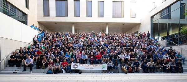
State of the Map (SotM) is an annual meeting of mappers from around the world with discussions and workshops all around the free and open map of the world. The conference is hosted by the OpenStreetMap Foundation, an international not-for-profit organization that is dedicated to encouraging the growth, development and distribution of free geospatial data and providing geospatial data for anyone to use and share.

The 2019 State of the Map event happened on September 21-23, 2019. This year SotM 2019 was held in partnership with the Institute of Geography of Heidelberg University in Germany. The event was themed Bridging the Map and invited people coming from different regions who in one way or another used OpenStreetMap in their works or fields share their knowledge, expertise and experience at the Neuenheimer Feld campus.

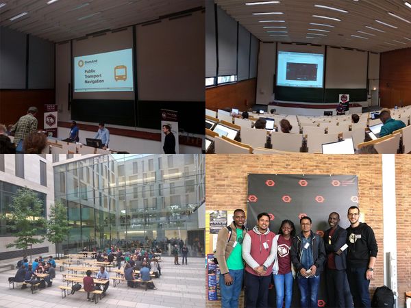
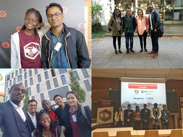
As YouthMappers selected as the Global Challenge winners coming from different chapters in different countries; Michael Kaluba of the Goodmappers from Uganda, Confidence Kpodo of the UCCYouthMappers from Ghana, Sawan Shariar from Dhaka College YouthMappers in Bangladesh, Aman KC from Geomatics Engineering Students Association of Nepal, Erneste Ntakobangize from Rwanda YouthMappers, and Diana Carolina Ortega Espinosa of the GeoLAB UdeA from Colombia, this was an opportunity for us to understand the extent to which our activities as YouthMappers could go in addressing issues or sectors we may not have thought of before.

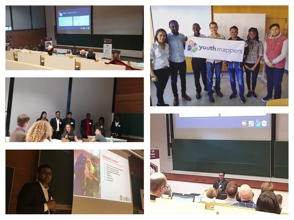
Our session, The Next Generation of Mappers: Learning from YouthMappers involved us giving lightning talks about the successful achievements in engaging youth on the platform and our unique challenges along with the proper solutions. In this session, we shared our chapters’ activities, dedication and contribution to engage youth as well as it’s challenges and some solutions put in place to address the challenges. The session was covered by each YouthMapper speaking on how their chapter engaged the youth through mapping with OSM and why there is a need to engage Youth.

Michael Kaluba from Uganda highlighted “How mapping on OpenStreetMap has provided opportunities to engage youths in ongoing community service projects and service learning (academia)engagements because youth have a unique perspective”

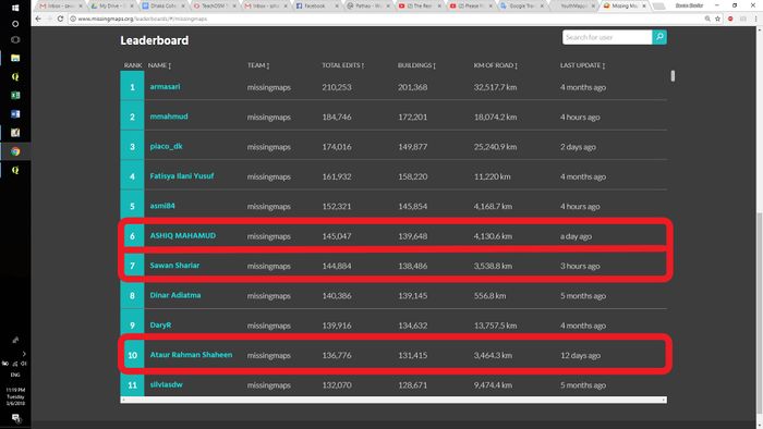
Sawan from Bangladesh also spoke in detail about the importance of engaging youth in mapping. He said “Youth are proactive and their prompt involvement towards a humanitarian cause is fast and well coordinated. They can introduce new knowledge, faster results, eliminate barriers and self sustainability of the community”

Confidence from Ghana described the advantages of engaging the Youth/YouthMappers stating “As a voluntary group, they come at a cheaper cost and provide you with the opportunity to work with local persons”

Carolina from Colombia spoke on the activities of YouthMappers using OSM by highlighting some of the mapping her chapter had carried out such as “Mapping the coastal wetlands of the Urabá Gulf for planners and the local fishing community to respond to flooding hazards in the area”

Aman from Nepal spoke about how institutions can engage the Youth by “Inspiring the youths working on projects, where they are contributing for the betterment of society”

Erneste from Rwanda spoke about the core attributes of a youth that makes them the best candidates to be engaged namely,”To do what the Youth can do, you need to fulfill the following criteria: Passion, Commitment, Humanity, Self motivation and solution-orientedness”

Traveling to Germany was a first time experience for all of us as we had never been to Europe. The entire experience of having to navigate our way through the Frankfurt Hauptbhanof to the Heidelberg Hauptbhanof without any prior knowledge of German was a memorable and learning experience.

With this situation, it required us having to rely on maps and gestures to get to our destinations.

Representing our YouthMappers chapters gave us the opportunity to share our chapters’ activities at the SotM global platform. Meeting other YouthMappers from different chapters all over the world was an opportunity to work together as a community, learn new things and create networks and friendships that are etched in the YouthMappers network. We also had the privilege to meet and network with YouthMappers partner organizations and students.

Learning should be about using knowledge gained in solving problems and making the community sustainable and happier. Being present at the Conference gave us the memorable experience of being able to share our work as YouthMappers and how OSM is used in our activities through our talks and interactions during and after the conferences through the social events organized. These events were grounds for us to network and learn in the vast world of OSM.

State of the Map enabled us to gain new knowledge and this new knowledge to be implemented in our local chapters and communities. We are already sharing my experience and knowledge with our existing community and newcomers face to face to motivate and inspire them more in doing this humanitarian activities and volunteering.

Through the conference we got the chance of meeting people from the OSM community from all around the world which was quite an insightful opportunity as we got to learn how OSM is being used in different contexts and continents.

For most of us, this was the biggest platform we had ever received and it definitely fell in line with our goals to do something different than we were used to. To be able to speak on such an international platform was a first for most of us and the feeling after was such a fulfilling one. We all returned home with different knowledge acquired but one thing is synonymous with us all, we’ve realized that the issues we face are not unsolvable and with strong community links in OSM we can make it.

We are proud to say that SotM 2019 has been an eye opening experience to see that through OSM the global map is being bridged and that as YouthMappers, we can contribute to it. We extend our heartfelt appreciation to Dr. Patricia Solis, Chad Blevins, Marcela Zeballos, Jessica Bergmann and the many people who guided us before, during and after the conference. You made it a memorable learning experience for us all. Danke!

Confidence Kdopo is part of the UCC YouthMappers chapter at the University of Cape Coast in Cape Coast, Ghana.

Michael Kaluba is part of the GoodMappers chapter at Busitema University in Tororo, Uganda.

S M Sawan Shariar is part of the YouthMappers chapter at Dhaka College in Dhaka, Bangladesh.

The blog is published on the YouthMappers blog site.

Please visit to read the blog https://www.youthmappers.org/single-post/2019/10/15/Bridging-the-Map-A-tale-of-Diversity

Bridging the Map: My Experiences

Posted by Sawan Shariar on 8 October 2019 in English. Last updated on 18 November 2019.

The State of the Map 2019 event happened on September 21-23, 2019. This year SotM 2019 was held in partnership with the Institute of Geography of Heidelberg University in Germany. The event was themed on Bridging the Map, people coming from different regions who in one way or another used OpenStreetMap in their works or fields shared their knowledge, expertise and experience at the Neuenheimer Feld campus.

Alt text

It’s an incredible experience. I still can’t believe that I have been to State of the Map 2019 in Heidelberg, Germany. First of all, I would like to thank the host “OpenStreetMap Foundation” of the State of the Map for inviting me as a scholar and Humanitarian OpenStreetMap Team (HOT) to extend this invitation to the HOT summit. And special thanks to Dorothea Kazzazi for guiding me from the beginning up until the conference concludes. She did awesome work for all of us to make sure that we got visas, accommodation, flights and train tickets. And the travel guide was very helpful to travel from Frankfurt Airport to Heidelberg.

Alt text

It’s a great networking opportunity. During the conference I have met many new people as well as some friends whom I had been communicating with online and that I now meet in real life. I can’t forget to mention some name, with whom I have talked about different topics during the conference and pleasure of meeting in person Patricia Solis, Rebecca, Marcela, Jessica, Ralph, Dorothea and Geofrey.

Alt text

A diverse program resulted in the challenge of choosing which presentations to attend and then quickly moving to the next presentation room. I have learned about OpenStreetMap activity around the world during the “Lightning Talks”. A few topics attract my attention and I have learned so many things from the sessions. There are some sessions that I have attended and I would like to share:

  1. What’s behind JOSM?
  2. Human Mapping with Machine Data
  3. SolidaryCityMap
  4. Imagery Solutions in OpenStreetMap
  5. Meet an OpenStreetMapper.

Alt text

During the conference I have got the opportunity to present my country in the lightning talks sessions. There I gave talks about the milestone achievement to contribute OpenStreetMap with engaging youth and specially female.

Alt text

Learning thing should be about solving problems and making the community sustainable and happier. State of the Map enabled me to gain new knowledge and this new knowledge to be implemented in Bangladesh OpenStreetMap community. I am already sharing my experience and knowledge with our existing community and newcomers face to face to motivate and inspire them more in doing this humanitarian activities and volunteering. The experience will be able to solve an issue within my community and it will help us to make a more sustainable community. And the experience will be able to help and organize properly SotM Asia 2019 in Dhaka, Bangladesh and already using that.

Alt text

End of the day, the experience exceeded all expectations and I hope to be able to participate in other State of the Map in the future. And many thanks again to the OpenStreetMap Foundation that made my trip to Germany for the first time in my life as well as the europe and participation in the event possible.

S M Sawan Shariar

Dhaka College, Dhaka, Bangladesh Photo

Sawan Shariar is an enthusiastic person for the mapping community in Bangladesh. He is coming from Economics background of Dhaka College in Bangladesh. He is an adviser and former President (founder) of YouthMappers Dhaka College Chapter. He is an associate member of OpenStreetMap Foundation and a core contributor & trainer of the local OpenStreetMap community. He is one of the core organizers of the Team BHOOT (Bangladesh Humanitarian OpenStreetMap Operational Team) which is an operational wing of OpenStreetMap Bangladesh Foundation (OSMBDF) and involved in local capacity building and supporting mapping initiatives. He is a “2019 Global YouthMappers Challenge Winners”. He has been involved with OSM & Geospatial platforms from 2015. In his journey with OSM he has contributed to several local and international mapping projects and has developed expertise in team coordination, leadership, remote sensing, field data collection and local volunteer organizer. He was the country representative speaker at State of the Map Asia 2018. He has provided training and facilitating to several educational institutes, local communities, NGOs and The Red Cross in Bangladesh. Currently he is leading the Map Your City project by Team BHOOT to cover the whole Bangladesh in map. He has an interest in leadership and elevating youth voices, Sawan is working and volunteered with Team BHOOT and The Red Cross where he has been able to support work that is mainly focused on these topics. He is one of the top contributor in Bangladesh and currently ranked #1 in the Missing Maps global leaderboard. He loves to travel to new places, learn the local culture and taste the local food.

Follow twitter, Instagram & LinkdIn

#LetGirlsMap for all boys YouthMappers chapter in Bangladesh

Posted by Sawan Shariar on 28 September 2019 in English. Last updated on 29 September 2019.

It is really a challenging part to work with female for all boys institute. And our society has conservative outlook of treating gender equally.But I believe in gender equality and it is the main key of every successful achievement. Nothing can exist without mutual participation of both boys and girls. And I am decided to do that for the sustainable community. So that we regularly collaboratively works with other educational institutes and local community in our country to increase engaging new mappers, especially girls.

Challenges: we have faced

To engage female mappers always we have faced many challenges. First of all it was the primary challenge to engaging female for all boy’s institute. But we are relentlessly working to increase engaging girls beside boys.

  • Ensure a safe environment

    In an under developing country it is a very crucial part is that every woman is concerned about the safe environment for her. So we have to ensure them that the mapping platform is a safe environment to the female.

Photo

  • Conservative society

    It is the general issue for the under developing country specially in the muslim society. Our society has conservative outlook of treating gender equally.

  • Women are not exposed to these technologies in other fields of study

    In our country it is another problem that woman is continuing her studies in any university they are not exposed to these technology is other fields of study.

Solutions: what we do

Engaging female mappers we have organized open training, workshops and seminar in various institutes collaborating with OpenStreetMap Bangladesh Foundation, Bangladesh Humanitarian OpenStreetMap Operational Team, Local Community and other educational Institutes in our country.

  • Clear vision of benefits of participation

    First of all it is a solution that motivate the female to the participation in OpenStreetMap. If she has a clear vision of the benefits of participation then she motive herself to work with OpenStreetMap.

Photo

  • Ensure a safe environment

    Ensuring a safe environment for the female we have to collaborate with local community, society club or educational institutes. As well as teachers, parents and POC of society.

  • All voices should be heard

    In the conservative society has conservative outlook of treating gender equally. They always dominate female and never took any decision from them. But we believe in gender equality and it is the main key of every successful achievement.

  • Sustainable and effective plan

    To make your sustainability efforts more efficient and effective. A plan is important because it focuses on the set of steps you will need to go through to achieve your ultimate goal, in this case an initiative with lasting impact. A planned effort will almost always be superior to an unplanned, disorganized attempt.

  • Passion and Dedication

    The passion and dedication is one of the most dominant and persistent characteristics of human nature to achieve any untouchable goal. It is the main key to any success.

  • Collaboration with local communities

    Collaboration is the main key to sustain a group or chapter. We can find all the energetic person from the local communities. They are reliable for the local entity. If we don’t collaborate with Local communities we can’t get any resource persons for the team and we can’t exist in the community.

We have done this difficult job with our passion and dedication as well as collaboration and contribution. We have made a positive wave to everyone’s heart and motive them to collaborate this platform. As a result we have got more than 100 female mappers in our community in the last few years with some top contributors they are ranked (5th, 11th and 49th) on the MissingMaps global leaderboard. We have planned to engage more female participants with our next footprints.

S M Sawan Shariar

Dhaka College, Dhaka, Bangladesh Photo

Sawan Shariar is an enthusiastic person for the mapping community in Bangladesh. He is coming from Economics background of Dhaka College in Bangladesh. He is an adviser and former President (founder) of YouthMappers Dhaka College Chapter. He is an associate member of OpenStreetMap Foundation and a core contributor & trainer of the local OpenStreetMap community. He is one of the core organizers of the Team BHOOT (Bangladesh Humanitarian OpenStreetMap Operational Team) which is an operational wing of OpenStreetMap Bangladesh Foundation (OSMBDF) and involved in local capacity building and supporting mapping initiatives. He is a “2019 Global YouthMappers Challenge Winners”. He has been involved with OSM & Geospatial platforms from 2015. In his journey with OSM he has contributed to several local and international mapping projects and has developed expertise in team coordination, leadership, remote sensing, field data collection and local volunteer organizer. He was the country representative speaker at State of the Map Asia 2018. He has provided training and facilitating to several educational institutes, local communities, NGOs and The Red Cross in Bangladesh. Currently he is leading the Map Your City project by Team BHOOT to cover the whole Bangladesh in map. He has an interest in leadership and elevating youth voices, Sawan is working and volunteered with Team BHOOT and The Red Cross where he has been able to support work that is mainly focused on these topics. He is one of the top contributor in Bangladesh and currently ranked #1 in the Missing Maps global leaderboard. He loves to travel to new places, learn the local culture and taste the local food.

Follow twitter

“I will do it. I want to do. I wish I will do it one day…” those sentences are not for this team. There is no place for a single performer. It’s a team. Here is not any places for the word ‘I’ without the word ‘We’. They are loves to say “We did it. We had done it.” The team is know that The word ‘We’ is more stronger than ‘I’. But here is a problem is that we don’t want to show the team’s work more than they talks. But by this blog we are wanting to inspire others for a competition of humanitarian work. We are a ultimate ghost. No one know us but feels so much by our works.

Missingmaps Leaderboard:

See the top 10 mappers of the missingmaps leaderboard. Here staying the three mappers (red marked).And if you see top 50 you will find more mappers of the team. missingmaps leaderboard

YouthMappersBD@Mapillary:

The team is contributed more than 50% mapillary photos. YouthMappersBD

Not only the statistics are the main issue. We have done all the works with maintaining quality of map data. We are already contributed more than 1.5 million buildings with around 55k km highways. All the contributions are maintaining quality.

We are ready to work for humanity. We was in action on Malaria Elimination, Nepal Earthquake, Tanznia Project, South Asian Flood or Rohinga Crisis. We achieved Chapter Partnership Award 2017 and took 3rd place on the YouthMappers ‘Mapping to End Malaria’ Challenge: Round-03 2017

It is realy true that all the great achievement was came by the teamwork. So that every team is always need to works together to achieve the big things. Best wishes to all chapters. See you all in the field of winners.

Location: 23.735, 90.383

OpenStreetMap(OSM) is the greatest invention of modern mapping system in this digitalized world. It is a great source of open data. It is more helpful and informative from any other online Map. In this MAP we get specific data. It is very helpful for peoples. By this map anyone can get information about his queries. Anyone can upload data and also can use data in their necessity. It is also helpful for the organizations that help vulnerable peoples. In this map we get the information about vulnerable area, way of passing, important point, water point etc. that is necessary for any kind of search and rescue operation in disaster. In this map data is free, so it is granted by everyone. It is easy to upload information in this map so anyone can contribute with the information from anywhere, anytime. OSM data is helpful for Vulnerable Capacity Assessment (VCA). By using this data different NGO, Government and International organizations can continue their relief operation. It is also helpful for research work. After all we can say, OSM data is very helpful for people for society as well as country. OSM data is very helpful for disaster risk management. In this map we get the data about identification of vulnerable places, way of passing, important key indicator as building condition, material, and structure by research this information govt. or relevant authority will identify the vulnerable places and take necessary steps to reduce the vulnerability, to reduce the damage of any kind of disaster. By using this data Bangladesh Red Crescent Society or this type of voluntary organization or Government organization like fire service, civil defense can plan their search & rescue operation.

I am Sawan Shariar from Bangladesh. I am an OpenStreetMap mapper and working since 14th May, 2015. I have done field level Mapping using GPS device, FieldPaper, OSMAnd, OpenMapKit, OSMTracker, Mapillary, MapSwipe and OSM Contributor. I upload data by using ID Editor, JOSM Editor and Potlatch 2. My complete mapper profile can be found at Sawan Shariar. I have done mapping for “Data for Action Project” and assisted in various OSM training with Bangladesh Red Crescent Society and continuing as a Super Mapper. I successfully completed The “Training for Trainer: OpenStreetMap” Training from Bangladesh Red Crescent Society supported by American Red Cross.

I am a volunteer of Bangladesh Red Crescent Society. And now I am working as Youth Chief of Red Crescent Youth, Dhaka College Unit (RCY,DCU). After successfully completed the Training for Training: OpenStreetMap I realize that, this training will be very useful for the volunteers of RCY,DCU. So I tried to understood my teachers and principal, how it’s effective and importance. And I successfully done that.

Red Crescent Youth, Dhaka College Unit is a voluntary organization, it started its journey in 2 may, 2004. It’s motto is serve the people. In its long journey it conducted many search & Rescue operation in different disaster. When the authority learn about the necessity and importance of OSM in disaster. They decided to arrange Training for the volunteers. In 22-24 August 2016, OpenStreetMap (OSM) training was conducted at Training room, Red Crescent Youth, Dhaka College Unit. This training was started sharp at 09.00am and it solely attended by the 26 volunteers of Red Crescent Youth, Dhaka College Unit.

Opening session was presided by Sheikh Sabbir Ahmed, Associate Professor of Dhaka College and Teacher In Charge of Red Crescent Youth ,Dhaka college Unit. As Chief guest there was present the pioneer of OpenStreetMap in Bangladesh [Ahasanul Haque] (https://www.openstreetmap.org/user/aHaSaN), Geospatial Data Management Consultant in World Bank Bangladesh. He gave his pleasant speech about OSM that inspires the Participants. Then the training Session started. The Training was conducted by Sawan Shariar, [Atikur Rahman atik] (https://www.openstreetmap.org/user/Atikur%20Rahman%20atik) and Manjurul Islam and assisted by Diluar Jahan & Atikul Islam.
On the first day training session was divided into 4 sessions, which were

  1. Introduction of OpenStreetMap

  2. Introduction and use of ID Editor in OSM

  3. Introduction and How to prepare Field Paper.

  4. Field work: Collect data using field papers

The practical session started with opening an account in ID editor, a web-based mapping tool and it always needed to be connected to the internet. Then all the students made their own OSM account using ID editor before the training session. The participants were learned how to configure the background layer and how to do basic edit with ID editor along with knowing additional information and custom tags. Data that used in editing in this session was specially the home address of the individual participants.

After the lunch break, the participants were introduced to the Field Papers website. The participants were taught how to create a printable map Atlas for anywhere in the world. They were learned how to print and add notes to the field papers. At last participants were paired into 13 team and sent to field for data collection. The first day of the training session was ended with the horizontal development with the shores of knowledge as well as the fervent smiling faces of the participants.

Second Day the training started with its full swing at the same place at the same time like the day before. The Second day of the training, the practical session divided into 5 sessions, which were-

  1. Review on previous day.

  2. Edit Upload data of previous day’s field work.

  3. Field work: Collect data using field papers

  4. Introduction and the Use of JOSM in OSM

  5. Upload collected data using JOSM Editor by participants.

The Sessions started with review on previous day works and upload data of previous day’s field works. After that, participants went outside again to collect data by using field paper. After the lunch break, the participants were introduced with JAVA Open Street Mapping (JOSM). They learned about interface of JOSM, activate imagery providers and upload data. After that they learned how to use JOSM offline by saving the important files for editing. And finally the second day’s training session ended up with uploading their collected data by using JOSM Editor.

Third Day the training started with its full swing at the same place at the same time like the first day. The Third day of the training sessions divided into 6 sessions, which were-

  1. Review on previous day.

  2. Field work: Collect data using field papers

  3. Edit & Upload their collected data

  4. Introduction in HOT &Teach Tasking Manager.

  5. OSM android apps & how to collect data by using it?

  6. Feedback & closing ceremony.

This day’s session started with Review on previous day works and upload data of previous day’s field works. After that participants sent outside to collect data by using field paper and after lunch participant edit & upload their collected data.

In the second session , the participants have instituted by the Humanitarian OSM Team collaborative mapping tool which is known as Humanitarian OpenStreetMap Team (HOT) Tasking Manager and Teach Tasking Manager. Participants also taught how to edit the maps both in teach and hot tasking manager not only editing by ID editor but also editing by JOSM. After that participants were introduced by many maps editing Mobile apps. The mobile apps are Mapswipe, OSM Tracker for Android, Map ME, Vespucci, Mapillary and OSMand.

The training was successful. The credit goes to The Honorable Principal Professor MD. Muazzom Hossain Mollah of Dhaka College. I am grateful to Sheikh Sabbir Ahmed & Farjana Islam, Associate Professor of Dhaka College and Teacher-in-charge of Red Crescent Youth, Dhaka College Unit. I am also grateful to [Ahasanul Haque] (https://www.openstreetmap.org/user/aHaSaN), The Pioneer of OpenStreetMap in Bangladesh and Geospatial Data Management Consultant in World Bank Bangladesh.

Some Important Questions for YouthMappers Trainer (From my Experienced)

Posted by Sawan Shariar on 14 August 2016 in English. Last updated on 27 October 2016.

If you are a Trainer of OSM or YouthMappers Platform you may have to face some common but very important questions. I want to try to find out this kinds of questions and give its suitable answer.

01. What is Map?

—–> Answer: A map is a symbolic depiction highlighting relationships between elements of some space, such as objects, regions, and themes.

02. What is OpenStreetMap?

—–> Answer: OpenStreetMap is a free, editable map of the whole world that is being built by volunteers largely from scratch and released with an open-content license. OpenStreetMap is, as the name suggests, an open source map of the world (www.openstreetmap.org). It has been built up in a concept similar to Wikipedia. It is called the free wiki world map, a collaborative project to create a free editable map of the world. A digital map is always handy for various purposes. It can be used in navigation, in research, in development of location based applications. When the map is free, its usability is guaranteed for everyone. And as OpenStreetMap is open source, its development is rapid and dynamic.

03. Why OpenStreetMap?

—-> Answer: OpenStreetMap is a free, editable map of the whole world that is being built by volunteers largely from scratch and released with an open-content license.

04. Why don’t you just use Google Maps/whoever for your data?

—-> Answer: Because that data is copyrighted and owned by multiple organisations like the Ordnance Survey. Google/whoever just licenses it. If we were to use it, we’d have to pay for it.

05. Who owns OpenStreetMap?

—-> Answer: You do. The data and software is owned by you, the contributors. There is an organisation called the OpenStreetMap Foundation which exists to protect, promote, and support the project, but does not own the data.

06. Why would you use OpenStreetMap if there is Google Maps?

—-> Answer: There is no ultimate answer as to which one is better. These two have as many similarities as differences. They are based on different fundamentals, but they solve the same basic human need to know “WHERE”. The key difference between these two mapping environments is a philosophic “Open” vs. “Closed” approach with how the data is collected and distributed. The main difference between these two services is that every edit you make to OSM is owned by you and the community, while every change you make to Google Maps… will be owned by Google. The OSM community is what makes the project so special. Thousands of volunteers from all around the globe are updating the map as their world changes around them. Every update is immediately visible to all other users and is version controlled. There are no corporate map cycle releases, approvals and KPIs that are typical to large organizations. This community is also what ensures the high quality and granularity of OSM maps. Although Google spends quite a lot of time and resources on keeping maps up-to-date, its data quality is not necessarily better than OSM. In many, especially less developed areas, the OSM community has managed to gain even higher data granularity than any other map source. Commercial map data suppliers usually focus on updating map features which are most profitable to sell. Since the OSM community does not have to worry about selling maps, it allows the community to be creative and make maps focused on hikers, cyclists, physically challenged, sailors and practically any interest group. You can map crops, the number of windows on Empire State Building or even the age of a particular tree. Even when it comes to routing and navigation, OSM doesn’t stay behind. Telenav has started using OpenStreetMap data in their Skobbler navigation app.

07. Advantages of OpenStreetMap

—-> Answer: Free:- UOpenStreetMap® is open data, licensed under the Open Data Commons Open Database License (ODbL) by the OpenStreetMap Foundation (OSMF). You are free to copy, distribute, transmit and adapt our data, as long as you credit OpenStreetMap and its contributors. If you alter or build upon our data, you may distribute the result only under the same licence. The full legal code explains your rights and responsibilities. The cartography in our map tiles, and our documentation, are licensed under the Creative Commons Attribution-ShareAlike 2.0 license (CC BY-SA). Full:- Actually no mapping service has 100% of the planet’s geographic information. However, OSM is constantly updated through collaboration of companies, government institutions and the wider community that often send information of new locations or corrections of the existing ones. This allows the service to have more precise information of places that are poorly known. Unlike Google Maps that focuses on detailing the information of the major cities. Without restrictions:- In services like Google Maps you must pay to use the service when the access traffic is high, while in OSM access is provided free and without any restrictions. Standard: OSM uses the standard EPSG: 4326, one of the most currently used in cartography. Customizable:- OSM is a service, and as such, it may be used by third party applications for customization. Currently there are APIs like Openlayers (Implemented in JavaScript) that allows you to create web applications using the OSM service, providing a rich set of functionality (set markers on the map, labels, overlapping layers, widgets, popups, among many other elements that can be seen on the website of examples). Fast:- Even sometimes it gives the impression that its loading is faster than Google Maps. Stable: Backed by the University College London (UCL) and Imperial College London (ILC) where the main servers stay. They also have distributed servers around the world to meet demand of users in a reliable and robust way. Effective:- The group of developers are constantly working on adding new features to the service.

08. Disadvantages of OpenStreetMap

—-> Answer: Documentation:- The official documentation is not complete and not very clear. Many times we must search in forums and blogs to understand some functionality. Incompatibility:- Some users have reported OSM erroneous behavior when it is used in conjunction with other tools. For example: Maps are displayed distorted when OSM is used with Twitter Bootstrap. However, this bug is easy to fix (we will share the solution in another article later).

I’m not saying that OpenStreetMap is perfect. No map is. But when you consider all pros and cons, maybe Google Maps is not the best solution for all use cases. There are many applications where the map should be treated as an important public good, rather than a commodity controlled by large organizations. At the end, why would you rely on a global corporation to tell you what is the name of a street in your own neighborhood? So don’t be afraid and try it out here http://learnosm.org/en

Location: Nilkhet, Azimpur, Dhaka, Dhaka Metropolitan, Dhaka District, Dhaka Division, 1209, Bangladesh

The key highway=* is the main key used for identifying any kind of road, street or path. The value of the key helps indicate the importance of the highway within the road network as a whole. See the table below for an ordered list from most important (motorway) to least important (service).

“Highway tagging samples”

Roads: motorway, trunk, primary, secondary, tertiary, unclassified, residential, service

Link Roads: motorway_link, trunk_link, primary_link, secondary_link, motorway_junction

Special: living street, pedestrian, bicycle road, track, bus guideway, raceway, road, construction, escape

Paths: footway, cycleway, path, bridleway, steps, escalator

Sidewalks : sidewalk, cycleway lane, cycleway tracks, bus and cyclists, lanes:psv, busway

Lanes: number of lanes, direction instructions (“turn lanes”), signposts

Data Source: https://wiki.openstreetmap.org/wiki/Key:highway https://wiki.openstreetmap.org/wiki/WikiProject_Bangladesh#To_Know_more_about_Bangladesh

Location: Katabon, Shahbag, Dhaka, Dhaka Metropolitan, Dhaka District, Dhaka Division, 1205, Bangladesh